英语考试作文-9分雅思图表写作范文全集之地图篇 滨海村庄
雅思地图题范文
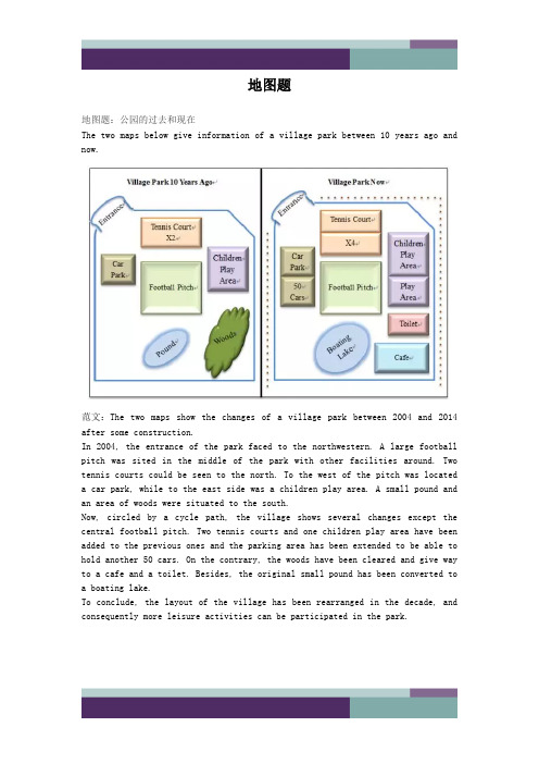
地图题地图题:公园的过去和现在The two maps below give information of a village park between 10 years ago andnow.范文:The two maps show the changes of a village park between 2004 and 2014 after some construction.In 2004, the entrance of the park faced to the northwestern. A large football pitch was sited in the middle of the park with other facilities around. Two tennis courts could be seen to the north. To the west of the pitch was located a car park, while to the east side was a children play area. A small pound and an area of woods were situated to the south.Now, circled by a cycle path, the village shows several changes except the central football pitch. Two tennis courts and one children play area have been added to the previous ones and the parking area has been extended to be able to hold another 50 cars. On the contrary, the woods have been cleared and give way to a cafe and a toilet. Besides, the original small pound has been converted to a boating lake.To conclude, the layout of the village has been rearranged in the decade, and consequently more leisure activities can be participated in the park.he i rb ei n ga re go od fo rs o 地图题:城市布局变迁The two maps show the changes of a city from 1960 to now.范文:The two maps show the development of a city from 1960 to the present.In 1960, the city was mainly based on the harbour and freight ships were moored in the northeast dock. To the east of the harbour was a business area, which was connected with the harbor and a stadium on the southern side of the river by trams. Moreover, two residential blocks were constructed at both the northern and southern ends of the city.Several major changes to the city have been observed since then. In 2014, the residential area in the north has given way to an extended business area of the one in the east. The previous dock has been occupied by some newly built restaurants and bars. The original intersecting tram frame has been simplified to a single line. Some sports facilities have been constructed between the southern residential area and the stadium, which is now also linked with the old business area by a footbridge over the river.To summarise, the landscape of the city has been rearranged, with more business replacing industry around the bay.d fo r地图题:学院布局变化The map below gives information about a college at present and its future view in 2015 after reconstruction.范文:The two figures demonstrate the estimated changes of a college between 2014 and 2015.At present, a garden lies in the northern part of the college and five car parks are located in the west. Both of them are linked to the school building by a footpath, while its entrance is in front of the garden. Inside thebuilding, a lunch area and two classrooms lie in the western side, while one more classroom, a reception and a library are in the eastern part. For the southern edge, there is a toilet in the middle, and a bus stop on the southwestern corner, accessed by a road.In 2015, several changes are expected to be witnessed. The garden and the footpath will be removed, since the teaching building will be extended. A new shop will be established in the building’s northwestern corner, and thelibrary will be moved to the southwestern end. Between them, there will be the original lunch area and one classroom, while other four classrooms will be seen in the opposite side. The entrance will be rebuilt in the middle southern edge,e an dAl t h i ng si nt he i rb ei n ga re go od adjacent to the bus stop, and the corridor behind it will be replaced by a reception.To summarize, more rooms and car parks will be constructed in the college during the period.地图题:消防设备布置The diagram shows the fire plan for the second floor of a student dorm building in a university. Summarise the information by selecting and reporting the main features and make comparison where relevant.范文:The map illustrates the escape routes in case of fire on the second floor of a university dormitory. There are one lift, two stairways and seven bedrooms on this rectangle shape floor, all with access to the corridor in the center. Once the building is on fire, the stairs on the south-west corner is convenient for the students living in the west part of the floor, specifically, Bedroom 1, 2 and 3 to escape through the corridor because Bedroom 1 and 2 are located in the northwest corner and Bedroom 3 is right opposite the stairway. When they rush out of the building, they can meet the others at the Meeting Point 1 outside the stairway.Another stairway which is sited at the north side of floor, with the lift at the west and Bedroom 7 the east, offers another escaping way in case of fire. Bedroom 4, and 6 are on the south side of the corridor but face to this stairway, and Bedroom 5 is at the east side of the floor, next to Bedroom 6,s o therefore it is also easy for the dwellers in these three rooms to rush out. Once they get out of the building, they would meet at the Meeting Point 2 near the stair room.When you are old and grey and full of sleep,And nodding by the fire, take down this book,And slowly read, and dream of the soft look Your eyes had once, and of their shadows deep;How many loved your moments of glad grace,And loved your beauty with love false or true,But one man loved the pilgrim soul in you,And loved the sorrows of your changing face;And bending down beside the glowing bars,Murmur, a little sadly, how love fledAnd paced upon the mountains overhead And hid his face amid a crowd of stars.The furthest distance in the worldIs not between life and deathBut when I stand in front of you Yet you don't know thatI love you.The furthest distance in the worldIs not when I stand in front of youYet you can't see my loveBut when undoubtedly knowing the love from both Yet cannot be together.The furthest distance in the worldIs not being apart while being in loveBut when I plainly cannot resist the yearningYet pretending you have never been in my heart. The furthest distance in the worldIs not struggling against the tidesBut using one's indifferent heartTo dig an uncrossable riverFor the one who loves you.。
雅思写作地图题深度解析(上)
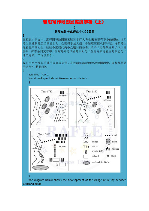
雅思写作地图题深度解析(上)?朗阁海外考试研究中心??姜芮?在雅思小作文中,流程图和地图题无疑对于广大考生来说都有不小的威胁,很多考生在遇到此类型的题目时,会变得手足无措,不知道应该从何写起。
许多考生抱着侥幸的心里,往往不重视此类小众题目的备考,结果作文分数受到了很大的影响。
在本系列文章中,朗阁海外考试研究中心写作组的专家将着重对雅思写作地图题做一个深度解析。
?我们用两个经典的地图题真题为例,在近两年出现的数次地图题中,多数都是属于这类“三格地图”。
?WRITING TASK 1You should spend about 20 minutes on this task.??The diagram below shows the development of the village of Kelsby between 1780 and 2000.Summarise the information by selecting and reporting the main features, and make comparisons where relevant.Write at least 150 words.?在审题过程中我们需要特别注意以下几点:1.?时态:关注时态是小作文能否取得高分的关键,同样对于地图题,我们也应该很好地注意时态,本文的时间是明确的,都是过去的时间,因此全文应当使用一般过去时。
2.?顺序:该图属于动态的地图题,这种类型的地图题一律按照时间顺序来写。
在这道题中,也就是按照图的顺序依次来写,不要把元素拆开。
如果是静态的地图题(即不涉及时间变化的题型),则按照空间顺序来写。
在描述单幅地图时,我们可以采取上北下南的顺序描述,或者从左到右的顺序也可以,但值得注意的是,如果地图上有明显的方向标示,那就要根据这个标示来描述。
?下面我们一起来分析文章的写作。
第一段:Introduction引言段就是把题目进行改写。
英语考试作文-雅思写作重点复习题型之地图

英语考试作文雅思写作重点复习题型之地图纵观雅思小作文历史,我们不难发现,近几年的地图题以“今夕对比”型为主流,而纵观2016-2017年的小作文题型,不难发现复习重点应该集中到表格,饼图(有可能混合)和地图上面,而表格图的写作语言都是“升降”“多少”这类常见的小作文词汇,只有地图题的语言积累并不是很多。
官方剑桥系列丛书只在剑9T1中提供了一篇7分的今昔对比类地图题的例文。
在此,老师尽最大的努力收集了语言质量较高的例文以及历年考过的类似题型,供考生学习练习。
雅思OG——Test3经典推荐:考官级口语写作9分范文资料超级大汇总(史无前例数百篇)The diagrams show West Part School at three different stages in its development: 1950, 1980 and 2010.In 1950, the school was built close to a main road and next to a number of houses. A large area behind the school was turned into a playground, while the area behind the houses was farmland.By 1980, the houses had been demolished in order to make way for a small car park and an additional school building, which became the science block. In addition to the existing playground, the school also gained the farmland and converted it into a sports field.In 2010, the school building remained unchanged but the car park was extended to cover the entire sports field. As a result of this, the original playground was divided into two so that it provided a smaller playground and a small sports field.During this period, the school has increased in size and a car park has been created and enlarged. The combined recreational areas, however, first expanded and were then reduced in size.需要积累的词汇:扩大:extend,enlarge,increase in size,expand缩小:reduce in size不变:remain unchanged从无到有:created,gained,converted into从有到无:be demolished(in order to make way for)练习一:参考范文:The maps given compare the current layout of a college with its plan in 2015.At present, to the north of the rectangular campus there is a garden opposite to the entrance. Along the west wall lie a footpath and a car park and the south a bus stop. Inside, two classrooms in the south and a bigger one in the northeastern corner can be found, on the south of which the reception and the library are sited. Not mentioned are the seemingly open area for lunch in the northwestern and the toilets in the south.The college in 2015 is expected to demonstrate many differences including its extended length, along with which the car park will also expand its size. The garden and the footpath will vanish while a shop will be introduced inside. Noticeably, the entrance and the toilets will exchange their places, with the former directly leading to an oval reception. Likewise, the library of a shrunk size will be moved to the southwestern corner where a classroom lies now. Along the east wall four classrooms will be located.Despite the differences, that all the facilities are built immediately adjacent to each other and against the wall will remain consistent.练习二:Illustrated in the map is how the village of Stokeford changed over the period from 1930 to 2010.As can be seen from the map, the village was unexploited and natural, with a north-south river in the west, which was crossed by a paralleled road in the north. A bridge was constructed over the intersection. Several shops and a post office were built along the western side of the road while a great number of houses, a primary school, and a garden with a large house inside were located opposite. Two expanses of farmland were situated on the two sides of the road.However, after 80 years, the village accelerated its pace of development, with more houses being established along the main road and its branches, replacing the original shops and garden. And also, the size of the primary school was expanded, doubling its previous scale. Besides, the former garden gives way for the newly-built retirement home. However, all the farmland disappeared.Overall, the village experienced a prosperous transformation and becomes a modern place for people to live.练习三:这个题大家自己动动笔吧!通过范文分析,大家是否已经找到了写作地图题的思路了呢?是否掌握了该类图形写作的常用表达了呢?希望同学们可以顺利通过年底的雅思考试。
雅思小作文范文-地图
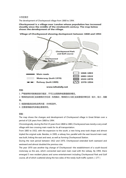
The development of Chorleywood village from 1868 to 1994.思路:1. 严格按照时间的推进进行描述,不可以出现倒序或是插叙的情况。
2. 物体的坐标词汇应该是绝对方位词:东西南北,物体的大小词汇应该是相对单位词:较大,较小,倍数等。
3. 线段的描述应该包含两方面:方向和动作。
4. 注意使用被动句来表达客观存在。
答案:The map shows the changes and development of Chorleywood village in Great Britain over a period of 126 years from 1868 to 1994.Chronologically, during the first 15 years from 1868 to 1883, Chorleywood was merely a very small village with two crossing main roads for its all transportation.From 1883 to 1922, with the expansion to the south, a new living area took shape and almost tripled the original scale. Besides, in 1909, a railway line, parallel with the east-bound main road, was built, linking the east and west, as well as forming Chorleywood Station.During the next period between 1922 and 1970, Chorleywood extended both eastward and westward and almost doubled the previous size.The year 1970 saw another big change of Chorleywood--the establishment of a south-bound motorway as the axis, which connected east-west main road with the railway. By 1994, there emerged 5 new resident places and some entertainment including Chorleywood Park and Golf course, all of which scattered along the two sides of the newly-built traffic system.(177)Two possible sites for a shopping mall in the city of Brandfield.思路:1. 注意描述的过程:可为由内至外,由外至内,由左至右,由上至下等。
我的家乡滨海英语作文100字

滨海:我美丽的家乡My hometown, Binhai, is a place where the sea meets the sky, where the sun rises and sets, and where the sounds of waves and seabirds fill the air. It's a city that's rich in history and culture, yet vibrant and modern at the same time.滨海,我的家乡,是一个海天相接的地方,是太阳升起和落下的地方,是海浪和海鸟声音充盈空气的地方。
它是一座历史文化底蕴丰厚,同时又充满活力和现代感的城市。
The cityscape of Binhai is a blend of old and new. The ancient temples and pagodas stand proudly alongside the modern skyscrapers and shopping malls. The bustling streets are a testament to the city's lively spirit, with people from all over the country converging here to make their dreams come true.滨海的城市景观新旧交融。
古老的寺庙和宝塔骄傲地与现代摩天大楼和购物中心并立。
繁忙的街道见证了城市的活力,来自全国各地的人们汇聚于此,为实现梦想而努力。
The beaches of Binhai are a major attraction, withtheir soft, white sand and crystal-clear waters. Onweekends and holidays, families and friends gather here to enjoy the sea breeze, build sand castles, and swim in the shallows. The seafood here is also a must-try, with fresh fish, crabs, and shellfish available at every turn.滨海的海滩是主要景点之一,柔软的白色沙滩和清澈见底的海水吸引了众多游客。
雅思地图题范文
雅思地图题范文雅思地图题是指考生需要描述和分析一幅地图的题目。
下面是一个关于雅思地图题的范文:The maps illustrate the changes that have taken place in a coastal area over a period of 60 years, between 1950 and 2010. The first map shows the area as it appeared in 1950, while the second map depicts the changes that have occurred by 2010.Overall, the most noticeable change is the development in the area. In 1950, the coast consisted mainly of natural features, including a sandy beach, some rocks, and a small area of vegetation. However, by 2010, the area had been transformed into a residential area with various buildings and infrastructure.In 1950, the beach occupied a large portion of the coastal area, extending from the northwest to the southeast. There were a few patches of vegetation scattered along the beach, particularly in the northeast corner. There were also a couple of rocks protruding from the water near the shore. On the other side of the beach, there was a small patch of flat land with some trees.By 2010, the beach had significantly reduced in size, with the sand giving way to residential buildings. In the northwest, there were a cluster of houses facing the beach, with a road running parallel to the coastline. Towards the southeast, there was a larger residential area, complete with a school, a shopping center, and a recreational park. The rocks that were present in 1950 had been removed to make way for a marina, where several boats and yachts weremoored.Furthermore, the area of vegetation in the northeast corner had been turned into a golf course, with well-manicured lawns and several ponds. The patch of flat land on the other side of the beach had been transformed into a golf driving range. In addition, a road had been constructed to connect the residential area to the rest of the city.In conclusion, the coastal area in question has undergone significant development over the past six decades. The beach has been overtaken by residential buildings, a marina has been built, and a large golf course and driving range have also been established.。
雅思小作文 地图题 村庄变迁

雅思小作文地图题村庄变迁In recent years, the transformation of rural villages has become a topic of great interest and concern. The rapid urbanization and modernization have led to significant changes in the landscape and lifestyle of these villages. This essay aims to discuss the factors contributing to the transformation of rural villages, the impact of these changes on the community, and potential solutions to address the challenges faced by these villages.One of the primary factors contributing to the transformation of ruralvillages is urbanization. As cities continue to expand, there is a growing demand for land and resources, leading to the encroachment of urban areas into rural villages. This has resulted in the displacement of local residents and the destruction of traditional agricultural practices. Additionally, the allure of better job opportunities and amenities in urban areas has led to a mass exodus of young people from rural villages, further contributing to the decline of these communities.Furthermore, the advancement of technology and infrastructure has also played a significant role in the transformation of rural villages. The introduction of modern amenities such as electricity, internet access, and transportation has brought about both positive and negative changes. While these advancements have improved the quality of life for some villagers, they have also led to the erosion of traditional values and practices. Moreover, the construction of new roads and buildings has altered the natural landscape of these villages, leading to environmental degradation and loss of biodiversity.The impact of these changes on the community has been profound. The social fabric of rural villages has been disrupted, leading to a sense of disconnection and loss of community spirit. The traditional way of life, which was once centered around agriculture and close-knit relationships, has been replaced by a more individualistic and consumerist mindset. This has resulted in a decline in thesense of belonging and identity among the villagers, leading to feelings of alienation and nostalgia for the past.In addition, the economic implications of the transformation of rural villages cannot be overlooked. The decline of agriculture and traditional industries has led to high levels of unemployment and poverty in these communities. Many villagers, especially the elderly, are struggling to make ends meet as they are unable to adapt to the changing economic landscape. This has led to a widening wealth gap and a sense of hopelessness among the villagers.Despite these challenges, there are potential solutions to address the issues faced by rural villages. One approach is to promote sustainable development and eco-tourism in these areas, which can help preserve the natural landscape and traditional way of life while providing economic opportunities for the villagers. Additionally, there is a need for investment in education and skills training to empower the younger generation and equip them with the tools to thrive in the modern world while preserving their cultural heritage.In conclusion, the transformation of rural villages is a complex issue withfar-reaching implications. While the changes brought about by urbanization and modernization have had a profound impact on these communities, there are opportunities to address the challenges and preserve the unique identity of rural villages. By embracing sustainable development and empowering the local community, it is possible to create a more inclusive and prosperous future for rural villages.。
英语考试作文-9分雅思图表写作范文全集之地图篇 村庄变迁
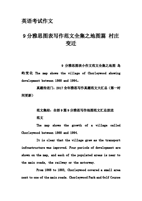
英语考试作文9分雅思图表写作范文全集之地图篇村庄变迁9分雅思图表小作文范文全集之地图岛屿变化The map shows the village of Chorleywood showing development between 1868 and 1994。
真题传送门:2017全年雅思写作真题范文大汇总(第一时间更新)范文集结:全部9篇9分雅思写作地图范文汇总放送范文The map shows the growth of a village called Chorleywood between 1868 and 1994.It is clear that the village grew as the transport infrastructure was improved. Four periods of development are shown on the map, and each of the populated areas is near to the main roads, the railway or the motorway.From 1868 to 1883, Chorleywood covered a small area next to one of the main roads. Chorleywood Park and Golf Courseis now located next to this original village area. The village grew along the main road to the south between 1883 and 1922, and in 1909 a railway line was built crossing this area from west to east. Chorleywood station is in this part of the village.The expansion of Chorleywood continued to the east and west alongside the railway line until 1970. At that time, a motorway was built to the east of the village, and from 1970 to 1994, further development of the village took place around motorway intersections with the railway and one of the main roads.(174)。
雅思写作八分经典范文背诵:图表范文

雅思写作八分经典范文背诵:图表范文ChorleywoodisavillagenearLondonwhosepopulationhasincreasedsteadil ysincethemiddleofthenineteenthcentury.Themapbelowshowsthedevelopmento fthevillage.Writeareportforauniversitylecturerdescribingthedevelopmen tofthevillage.该地图显示的是英国Chorleywood村从1868年至XXXX年总计126年里的发展与变化。
ThemapshowsthechangesanddevelopmentofChorleywoodvillageinGreatBritain overaperiodof126yearsfrom1868toXXXX.从年代的变迁来看,从1868-1883的15年里,Chorleywood仅仅是一个很小的村庄,西面有一条主路。
1883-1922年,村庄的规模向南扩大了近三倍,而且在1909年有了一条铁路线东西横穿新区,有了Chorleywood火车站。
1922-XXXX年,村庄从东、西两面又扩大了一倍多。
XXXX-XXXX年间,村庄加速向东面扩展,形成了以建于XXXX年的南北方向的机动车公路为中轴、以差不多平行的东西向主路和铁路为切分线的五大区域,规模比原来又扩大了一倍多,Chorleywood公园和高尔夫球场将新区与老区分隔开来。
Chronologically,duringthefirst15yearsfrom1868to1883,Chorleywoodwasmer elyaverysmallvillagewithonemainroadtoitswest.From1883to1922,weseethat thevillageexpandedtosouth,almosttripledtheoriginalscale.Besides,arail waylinewasbuiltacrossthenewareafromwesttoeastandthereemergedtheChorle ywoodStation.During1922-XXXX,Chorleywoodextendedbotheastwardandwestwa rdandalmostdoubledtheprevioussize.ThenduringXXXX-XXXX,thevillageaccel erateditspaceofdevelopmenteastwardandthreenewareastookshapewithanorth -southmotorwaybuiltinXXXXastheaxis,withthealmostparalleledeast-westma inroadandrailwayastwodividinglines,cuttingthisnewareaintofiveparts.Th isnewexpansionwasalmosttwicethescaleoftheoldvillage.TheChorleywoodPar kandagolfcourseseparatedtheoldandnewarea.由此,我们看到了这个小村庄100多年里的快速发展史。
雅思地图范文
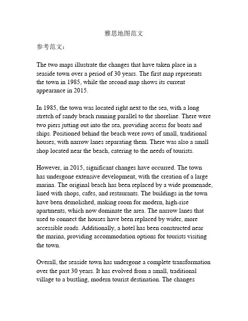
雅思地图范文参考范文:The two maps illustrate the changes that have taken place in a seaside town over a period of 30 years. The first map represents the town in 1985, while the second map shows its current appearance in 2015.In 1985, the town was located right next to the sea, with a long stretch of sandy beach running parallel to the shoreline. There were two piers jutting out into the sea, providing access for boats and ships. Positioned behind the beach were rows of small, traditional houses, with narrow lanes separating them. There was also a small shop located near the beach, catering to the needs of tourists.However, in 2015, significant changes have occurred. The town has undergone extensive development, with the creation of a large marina. The original beach has been replaced by a wide promenade, lined with shops, cafes, and restaurants. The buildings in the town have been demolished, making room for modern, high-rise apartments, which now dominate the area. The narrow lanes that used to connect the houses have been replaced by wider, more accessible roads. Additionally, a hotel has been constructed near the marina, providing accommodation options for tourists visiting the town.Overall, the seaside town has undergone a complete transformation over the past 30 years. It has evolved from a small, traditional village to a bustling, modern tourist destination. The changesreflect the town's efforts to attract more tourists and provide them with a range of amenities and facilities.。
雅思小作文真题范文-:地图题范文
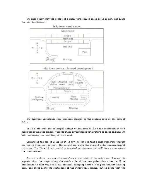
The maps below show the centre of a small town called Islip as it is now, and plans for its development.The diagrams illustrate some proposed changes to the central area of the town of Islip.It is clear that the principal change to the town will be the construction of a ring road around the centre. Various other developments with regard to shops and housing will accompany the building of this road.Looking at the map of Islip as it is now, we can see that a main road runs through its centre from east to west. The second map shows the planned pedestrianisation of this road. Traffic will be diverted on to a dual carriageway that will form a ring around the town centre.Currently there is a row of shops along either side of the main road. However, it appears that the shops along the north side of the new pedestrian street will be demolished to make way for a bus station, shopping centre, car park and new housing area. The shops along the south side of the street will remain, but it seems that thetown’s park will be reduced in size so that more new houses can be built within the ring road.(187 words, band 9)。
英语考试作文-9分雅思图表写作范文全集之地图篇 村庄变迁

英语考试作文9分雅思图表写作范文全集之地图篇村庄变迁9分雅思图表小作文范文全集之地图岛屿变化The map shows the village of Chorleywood showing development between 1868 and 1994。
真题传送门:2017全年雅思写作真题范文大汇总(第一时间更新)范文集结:全部9篇9分雅思写作地图范文汇总放送范文The map shows the growth of a village called Chorleywood between 1868 and 1994.It is clear that the village grew as the transport infrastructure was improved. Four periods of development are shown on the map, and each of the populated areas is near to the main roads, the railway or the motorway.From 1868 to 1883, Chorleywood covered a small area next to one of the main roads. Chorleywood Park and Golf Courseis now located next to this original village area. The village grew along the main road to the south between 1883 and 1922, and in 1909 a railway line was built crossing this area from west to east. Chorleywood station is in this part of the village.The expansion of Chorleywood continued to the east and west alongside the railway line until 1970. At that time, a motorway was built to the east of the village, and from 1970 to 1994, further development of the village took place around motorway intersections with the railway and one of the main roads.(174)。
雅思图表写作:地图

发展型
fish market and fishing port --> fish market became apartments; fishing port has been removed
expected to ) 又可为: It is likely that the number of homes in Town A will double. (it is likely that = it is predicted/estimated/projected/ expected
that…..)
Draw by yourself
The playground is roughly in the middle of the residential zone. The bank is in the northwest corner of the residential zone. Houses are at the bottom of the residential zone. The motorcyclist is outside the residential zone. The barber’s is opposite to the bank The supermarket is halfway between the bank and the barber’s. The supermarket is directly opposite to the stop. A local bus is to the right of the station.
雅思小作文剑9 island 地图

The two maps below show an island, before and after the construction of some tourist facilities.Looking at the second map in more detail, we can see that a new reception is constructed in the center of the island, with two groups of accommodation: one on the east and the other on the west.The maps show the changes taking place in a small island before and after the construction for tourism. It is clear that the island has changed considerably and there are 6 new features between the original island and the new one.According to the first map, before development, the island is completely bare, with a beach in the west. The total length of the island is approximately 1500 metres.Looking at the second map in more detail, we can see that two groups of small huts are built to accommodate visitors to the island, with a reception building in the middle. A restaurant is located to the north of the reception. To the east of the reception building, there is a pier, where boats can dock. Short vehicle tracks are constructed to link the pier with the reception and restaurant, while footpaths connect the huts. Finally, a swimming area is opened for tourists on the western tip of the island.。
雅思地图小作文

雅思地图小作文英文回答:The map depicts the proposed redevelopment of a coastal area. Currently, the area is mainly used for agricultural purposes, with some residential and commercial development along the coastline. The redevelopment plan includes the construction of a new marina, a hotel, and a residential development. The plan also includes the creation of new public spaces, such as a park and a promenade.The redevelopment plan has a number of potential benefits. The marina will provide a safe harbor for boats and will attract tourists and boaters to the area. The hotel will provide accommodation for visitors and will create jobs in the hospitality industry. The residential development will provide new housing for residents and will increase the population of the area. The new public spaces will provide places for people to relax and enjoy the outdoors.However, the redevelopment plan also has some potential drawbacks. The construction of the marina will require dredging of the seabed, which could damage the marine environment. The hotel and residential development will increase the density of development in the area, which could lead to traffic congestion and noise pollution. The new public spaces will require maintenance, which could be a financial burden for the local authority.Overall, the redevelopment plan has the potential to bring both benefits and drawbacks to the area. It is important to weigh the potential benefits and drawbacks carefully before making a decision about whether or not to proceed with the plan.中文回答:该地图描述了沿海地区拟议的重建。
我的家乡滨海英语作文
我的家乡滨海英语作文Title: My Hometown by the SeaMy hometown is a beautiful coastal city located in the southern part of China. It is known for its stunning beaches, delicious seafood, and vibrant local culture. The city is surrounded by the shimmering waters of the South China Seaand is blessed with a mild climate all year round.One of the main attractions of my hometown is its picturesque beaches. The soft golden sand stretches for miles along the coastline, offering the perfect spot for sunbathing, picnicking, and swimming. The crystal clear waters are ideal for water sports such as surfing, sailing, and snorkeling.The beach is always filled with laughter and joy, as locals and tourists alike enjoy the natural beauty of the sea.In addition to its natural beauty, my hometown is also famous for its delectable seafood. The local fishermen bringin a fresh catch of fish, crab, and shrimp every day. These seafood delicacies are then served in the numerous restaurants and food stalls throughout the city. From steamed fish to spicy crab, there is a dish to satisfy every seafood lover's palate. The aroma of grilled fish and sizzling prawns fills the air, creating a mouth-watering sensation for all who visit.Furthermore, my hometown boasts a rich and diverse local culture. The city is home to a number of historic temples, traditional markets, and old streets that have preserved the customs and traditions of the past. The annual Dragon Boat Festival and Mid-Autumn Festival are celebrated with great enthusiasm, with colorful parades, music performances, and traditional folk dances. These cultural events bring the community together and offer visitors a glimpse into the heritage and traditions of the region.Living in a coastal city also means that seafood is sortof like a way of life there. The locals have developed unique cooking methods and recipes that have been passed down from generation to generation. The dishes are not only delicious, but they also reflect the vibrant culture and history of the city.In conclusion, my hometown by the sea is a place ofnatural beauty, delicious cuisine, and rich cultural heritage. Its stunning beaches, mouth-watering seafood, and vibrantlocal culture make it a truly special place. I am proud tocall it my hometown, and I hope that more people will havethe opportunity to experience the charm and beauty of this coastal city.。
雅思小作文地图题范文
现在停车场改成了一个剧院。
The car park has been removed and replaced by a theatre.城镇A的家庭数量从1937年到2020年将翻一番。
The number of homes in Town A is likely to double(is likely to= is predicted to /is estimated to/is projected to/is expected to )又可为:It is likely that the number of homes in Town A will double.(it is likely that = it is predicted/estimated/projected/ expected that…..)细节变化地图每个细节变化都要提到,不要忽视一个细节语态雅思小作文地图题写作用被动语态,因为叙述的是一个事实,被动语态表达的更加的清晰,准确。
如: 2000年在城镇A 新建了一个医院:A new hospital was established in Town A in 2000.2014年开始,流程图与地图题的频率已经于其他图表题的频率不相上下,甚至有超过他们的趋势,2014年截止9月20日地图题已经考了4次,流程图也是4次。
你还在备考时忽略这两种图吗?地图题句式总结:1. A lies/is situated in/is located in/on/to the east of B.A 位于B的东面2.A covers an area of about….square meters/ hectares.A的面积大概有。
平方米/公顷A covers a small area in 1980.在1980年 A的面积很小。
3.A, which used to be located in…., is replaced by….原本位于。
滨海新区中考英语作文范文

滨海新区中考英语作文范文Possible essay:Binhai New Area。
Binhai New Area is a rapidly developing region located in the eastern part of Tianjin, China. It covers an area of 2,270 square kilometers and has a population of over 3 million. Since its establishment in 2005, Binhai New Area has become a hub of innovation, industry, and international cooperation.One of the most remarkable features of Binhai New Area is its strategic location. It is situated at the intersection of the Bohai Sea and the Haihe River, which provide convenient access to the sea and the inland waterway transportation system. Binhai New Area is also adjacent to Beijing and Hebei Province, two of the most populous and prosperous regions in China. This geographical advantage has made Binhai New Area a popular destinationfor investment and business.Binhai New Area is home to a wide range of industries, including advanced manufacturing, modern services, andhigh-tech research and development. It has attracted many leading companies from China and abroad, such as Airbus, Samsung, and Tencent. The local government has alsoinvested heavily in infrastructure, education, and healthcare, creating a favorable environment for innovation and entrepreneurship.Binhai New Area is not only a center of economic growth, but also a cultural and tourist destination. It has many landmarks and attractions, such as the Tianjin Binhai Library, the Haihe Cultural Square, and the YujiapuFinancial District. Visitors can also enjoy the local cuisine, which features fresh seafood, traditional snacks, and fusion dishes.In conclusion, Binhai New Area is a dynamic and promising region that showcases China's achievements in modernization and globalization. Its strategic location,diversified industries, and rich culture make it a model of sustainable development and international cooperation. As a resident of Tianjin, I am proud of Binhai New Area and look forward to its bright future.。
英语我的家乡作文(滨海)

英语我的家乡作文(滨海)English: My hometown, located on the coast, holds a special place in my heart. Its serene beaches, with their golden sands and rhythmic waves, have been the backdrop to countless cherished memories. The salty breeze that caresses my face as I stroll along the shore invokes a sense of calm and tranquility like no other. Beyond the coastline, the bustling harbor serves as a gateway to trade and adventure, with ships of all sizes coming and going, their sails billowing in the wind. The maritime culture runs deep in my hometown, evident in the seafood delicacies that grace our tables and the lively festivals that celebrate our connection to the sea. Yet, amidst the vibrant energy of the harbor, there lies a quiet charm in the narrow streets of the old town, where traditional architecture whispers tales of bygone eras. The warmth of the community, where neighbors greet each other by name and stories are shared over steaming cups of tea, fosters a sense of belonging that is irreplaceable. As the sun sets over the horizon, painting the sky in hues of orange and pink, I am reminded once again of the simple beauty and enduring spirit of my coastal hometown.Translated content: 我的家乡位于海岸,它在我心中有着特殊的地位。
- 1、下载文档前请自行甄别文档内容的完整性,平台不提供额外的编辑、内容补充、找答案等附加服务。
- 2、"仅部分预览"的文档,不可在线预览部分如存在完整性等问题,可反馈申请退款(可完整预览的文档不适用该条件!)。
- 3、如文档侵犯您的权益,请联系客服反馈,我们会尽快为您处理(人工客服工作时间:9:00-18:30)。
英语考试作文
9分雅思图表写作范文全集之地图篇滨海
村庄
9分雅思图表小作文范文全集之地图滨海村庄The map below shows the development of a seaside village between 1995 and present.Write a short report for a university lecturer describing the information shown below.Write at least 150 words.
范文集结:全部9篇9分雅思写作地图范文汇总放送
参考范文:
The two maps show the layout of the same seaside village in 1995 and at present.
Overall, it is evident that the infrastructure for housing and recreation has increased at the expense of agricultural land and commercial fishing.
The most notable changes are the disappearance of the fishing port and adjacent fish market, as well as the creation of a golf course and tennis courts in the north-east, where
farmland and a forest park were still found in 1995. furthermore, a new housing development containing apartments is now found on the waterfront at the former site of the fish market, and a number of restaurants have been built on the opposite side of the road where shops used to be.
There was also an increase in the total number of houses, from 12 in 1995 to 16 at present. In addition, the road encircling a small housing development west of the main road has been extended further westward.
The hotel and cafe in the south-east have remained as is. A new car park has been added next to the hotel.
Total Words: 180
Task Achievement: 9
Coherence & Cohesion: 9
Lexical resources: 9
Grammar: 9
Overall Score: Band 9。
