仪表等级飞行员理论培训stage1-107VOR
合集下载
仪表等级飞行员理论培训stage1-107 VOR
Only one VOR receiver is required for instrument flight But having 2 helps simplify your arrival at intersections
2 centered needles tells you that you’ve arrived at the intersection with 1 receiver, track your course and tune in the off-airway radial with FROM Needle will deflect toward off airway station until you arrive at intersection then it will center and move away from station after you pass the intersection
All aircraft located in a POSITION where flying in the direction
selected on the OBS would take them away from the station will
have a FROM indication
CDI / TO-FROM
CONE OF CONFUSION: over the station
ZONE OF AMBIGUITY: “ABEAM” the station The VOR will indicate “OFF” or “NAV” flag indications when over or abeam the station or when out of range and not receiving a reliable signal.
仪表等级飞行员理论培训stage1-104 PITOT-STATIC资料

International Standard Atmosphere
• ISA
– Standard Sea level Pressure 29.92 Hg. • 1013.2 Mb. – Standard temperature • Sea Level 15 C (59 F) • Standard Lapse rate 2 C per 1000 feet
Airspeed Indicator Measures pressure differential
•
Types of Airspeed:acronym “ICET ” Indicated airspeed
– Indication on airspeed indicator – Use same indicated airspeed for take-off & landing regardless of altitude or temperature
– Indicated – Pressure – Density – True – Absolute
Altitude types are different because of reference point. • Indicated altitude
– what you read when barometric pressure is set to current altimeter setting – IFR below 18,000’ MSL
– Airspeed (AI) – Altimeter (ALT) – Vertical Speed (VSI)
– AIRSPEED INDICATOR
Airspeed Indicator
仪表等级飞行员理论培训stage5210APPROACHPROCEDURES
APPROACH
Approach Procedures
Safely Finding The Airport
Precision Approaches
Precision Approaches provide vertical guidance in addition to lateral guidance, most often through the use of an electronic glideslope. Precision Approaches include:
Final Segment of a VOR Approach (non-precision with FAP)
Missed Approach Segment
Navigate from MAP to missed approach holding point. Depicted on every approach
• NDB
• RNAV (GPS)
• ASR – Airport Surveillance Radar
• Localizer (front & back courses)
• LDA / SDF / RNAV
The United States Standard for Terminal Instrument Procedures (TERPS) is the approved criteria for formulating instrument approach procedures.
–Intermediate fix (IF) –Begins at point where you are
proceeding inbound to the final approach fix, properly aligned. –Not all approaches have an intermediate fix
仪表等级理论训练大纲-仪表飞行航图
3.1.2 .4着陆最低标准
3.1.2 .5飞机进近种类
3.1.2 .6所需能见度
3.1.2 .7最低下降要求
3.1.2 .8不工作部分
3.1.3其它进近程序
3.2机场图
3.2.1表头部分
3.2.2机场概览和使用说明
3.2.3起飞和备降最低标准
2.1.5机场
2.1.6空域
2.2区域图
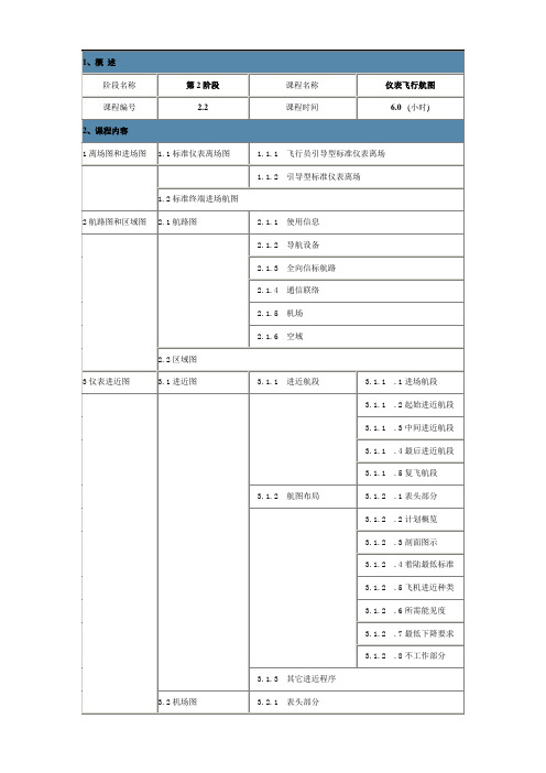
3仪表进近图
3.1进近图
3.1.1进近航段
3.1.1 .1进场航段
3.1.1 .2起始进近航段
3.1.1 .3中间进近航段
3.1.1 .4最后进近航段
3.1.1 .5复飞航段
3.1.2航图布局
3.1.2 .1表头部分
3.1.2 .2计划概览
3.1.2 .3剖面图示
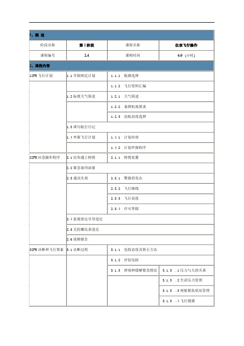
1、概述
阶段名称
第2阶段
课程名称
仪表飞行航图
课程编号
2.2
课程时间
6.0(小时)
2、课程内容
1离场图和进场图
1.1标准仪表离场图
1.1.1飞行员引导型标准仪表离场
1.1.2引导型标准仪表离场
1.2标准终端进场航图
2航路图和区域图
2.1航路图
2.1.1使用信息
2.1.2导航设备
2Hale Waihona Puke 1.3全向信标航路2.1.4通信联络
3.1.2 .5飞机进近种类
3.1.2 .6所需能见度
3.1.2 .7最低下降要求
3.1.2 .8不工作部分
3.1.3其它进近程序
3.2机场图
3.2.1表头部分
3.2.2机场概览和使用说明
3.2.3起飞和备降最低标准
2.1.5机场
2.1.6空域
2.2区域图
3仪表进近图
3.1进近图
3.1.1进近航段
3.1.1 .1进场航段
3.1.1 .2起始进近航段
3.1.1 .3中间进近航段
3.1.1 .4最后进近航段
3.1.1 .5复飞航段
3.1.2航图布局
3.1.2 .1表头部分
3.1.2 .2计划概览
3.1.2 .3剖面图示
1、概述
阶段名称
第2阶段
课程名称
仪表飞行航图
课程编号
2.2
课程时间
6.0(小时)
2、课程内容
1离场图和进场图
1.1标准仪表离场图
1.1.1飞行员引导型标准仪表离场
1.1.2引导型标准仪表离场
1.2标准终端进场航图
2航路图和区域图
2.1航路图
2.1.1使用信息
2.1.2导航设备
2Hale Waihona Puke 1.3全向信标航路2.1.4通信联络
仪表等级飞行员理论培训

理论培训的考核标准
ห้องสมุดไป่ตู้
仪表等级飞行员理论培训的考核 内容
仪表等级飞行员理论培训的考核 标准
添加标题
添加标题
添加标题
添加标题
仪表等级飞行员理论培训的考核 方式
仪表等级飞行员理论培训的考核 结果
P仪A表R等T级5飞行员理论培训的实
践应用
仪表等级飞行员在飞行中的实践应用
仪表等级飞行员的基本要求:具备相应的理论知识和技能,能够熟练操作飞行仪表和设备。
法与要求
理论培训的方法
制定培训计划:根据学员的实际 情况和需求,制定合理的培训计 划
教学方法:采用多种教学方法, 如讲解、演示、模拟训练等
添加标题
添加标题
添加标题
添加标题
教学内容:包括仪表等级飞行员 的理论知识、操作技能、安全知 识等
教学评估:对学员的学习情况进 行评估,及时调整教学计划和教 学方法
YOUR LOGO
仪表等级飞行员理 论培训
,a click to unlimited possibilities
汇报人:
时间:20XX-XX-XX
目录
01
添加标题
02
03
04
05
06
仪表等级飞行 员培训的重要 性
仪表等级飞行 员理论培训的 内容
仪表等级飞行 员理论培训的 方法与要求
仪表等级飞行 员理论培训的 实践应用
先进技术的应用:随着科技的不断进步,无人机、人工智能等先进技术的应用将为仪表等级飞行 员培训提供更多的实践机会和培训手段。
国际化趋势:随着全球化的加速,跨国航空公司的不断扩张将为仪表等级飞行员提供更多的就业 机会和国际化发展机遇。
(精品)仪表等级飞行员理论培训stage1-109RNAV-GPS1A

GPS Architecture
The GPS Positioning Concept
• Two principal pieces of information are required to determine a GPS position: ➢Position of each satellite ➢Range from the satellite to the user
What might a Flight Management System do for a pilot?
•Position •Airspeed •Groundspeed •Altitude hold •ETE / ETA •Heading •Course
• Ground Track • Fuel Burn
Once the Waypoint is set up in the receiver, the pilot simply treats it as though it were a real VOR
Programming the RNAV
Flight Management Systems: A Definition
• A minimum of four satellite signals are required to solve for an unaided, unique, position and time solution.
How Does GPS Work? Basic Function of GPS
Ground Antennas
GPS Architecture
User Element
• Consists of antennas and receiver/processors on board an aircraft, automobile, ship, cellular telephones and other new items like watches that provide positioning, velocity and precise timing to the user.
仪表等级飞行员理论培训stage1-103 GYROS-COMPASS
• Does NOT show if the aircraft is turning, climbing or descending
ATTITUDE INDICATOR
How an AI Works
• Principle of operation:
-RIGIDITY IN SPACE
• Gyro spins in horizontal plane on a
models)
• Caging devices were necessary for acrobatic flight to prevent tumbling
• Newer Attitude Indicators do not have the same limits so no caging
Heading Indicator
Acceleration / Deceleration Errors
• Example - accelerate
– Horizon bar moves down
– Incorrectly indicates a climb – ‘Confirmed’ by pilot’s somatogravic
Equipment tests & inspections required for IFR
• Airworthiness Directives (recurring/one-time) • VOR (preceding 30 days) • Inspections (Annual/100 hour if for hire) • Altimeter (preceding 24 calendar months • Transponder (preceding 24 calendar months) • ELT (preceding 12 calendar months) • Static system (preceding 24 calendar mo.)
仪表等级飞行员理论培训stage1-108HSI,ADF,RMI,DME剖析

• We’ll talk about this more when we learn about ILS
HSI: FAA Fig. 95
HSI: FAA Figs. 98 & 99
Which aircraft symbol represents the indications of HSI ‘A’, ‘B’, etc.?
– Think of the ‘N’ or ‘0’ at the top of the dial as representing the “NOSE” of the aircraft rather than North.
Movable Card Indicator
–With MH set on movable card ADF • Tip of needle points to magnetic bearing TO NDB • Tail of needle points to magnetic bearing FROM NDB
RANGE REPLY SIGNAL
INTERROGATION SIGNAL
Distance Measuring Equipment (DME)
DME Identification
(Morse code approx. every 30 seconds)
•DME Cautions: Slant Range Distance
ADF Formula
– MH + RB = MB –Magnetic Heading (MH) –Relative Bearing (RB) –Magnetic Bearing (MB) –TO the station
–(add/subtract 180 for FROM)
仪表飞行课程

仪表飞行课程
飞行仪表介绍
1.1 介绍
当仪表显示的精确程度使飞行员不需要持续对地面进行目视观察时,飞机也随之成为 了一种更加实用的运输方法。飞行仪表对于安全飞行非常重要,飞行员必须对仪表有 全面的认识。目视飞行规则(VFR)下所需要的基本飞行仪表包括空速表(ASI)、高 度表、磁罗盘。
除了这些,仪表飞行规则下(IFR)所需要的仪表还包括陀螺转弯率指示器、侧滑指示 器、可调节气压的高度表、时钟、陀螺俯仰坡度指示器(地平仪)以及陀螺方向指示 器(陀螺半罗盘或者其他相同效果的设备)。
鼓形机载高度计简图, 在左下角和右下角可见 科尔斯曼窗口
图示展示了一个具有三根指针的灵敏航空高度计显示当前高 度为10,180英尺
10 000 ft
100 ft
1000 ft
29.9mmHg
1.3.1.3 机械式误差
1.3.1.2 高度表的误差
气压式高度表的设计是符合标准 状况下气压的标准变化规律的, 但是大多数飞行都会由于非标准 的飞行条件而产生误差,飞行员 必须对这些指示进行相应的修正。 其误差有两种类型:机械式和固 有式。
在温度极低的情况下,飞行员需要参考增加适当的温度修 正量,使用表中标注的IFR 高度以保证在以下限制 条件下的地形及越障高度:
由空中交通管制(ATC)特别指定的高度不需要修正 ,例如“保持5000 英尺”。如果飞行员确定较低的温度 可能会导致离地或者距离障碍物高度不够,飞行员可以拒 绝该指定高度。
气压式高度表配有可调节的气压刻度,允许飞行员在测量高度时调定基准气压。气 压刻度显示在一个被称为高度表气压调定窗的小窗口内。飞行员可以使用仪表上的 旋钮来调节刻度。刻度表的范围从28.00 到31.00 英寸汞柱(Hg)或者948 到1050 百帕。飞行员可以通过转动旋钮来改变气压刻度以及高度表指针。在5000 英尺以下 ,标准的气压递减率为:气压刻度每改变1"Hg,则指针指示改变1000英尺。当气 压刻度调节到29.92"或者1013.25 百帕,指针指示的是标准气压高度。将气压刻度 调整到当地的修正气压值,则高度表指示当前海平面气压高度(修正气压高度)。
仪表等级飞行员 理论培训

• Mandatory Instruction Signs • Location Signs • Direction Signs • Destination Signs • Information Signs • Runway Distance Remaining Signs
Airport Signs • Most airfield signs are standardized.
LAHSO
• Land and Hold Short Operations
– In effect at some controlled airports
• Could be at:
– Intersecting runway – Intersecting taxiway – Designated point on the runway
– Xs or simply blocked off
• Displaced Threshold
– Begin/end normal operations for takeoff and landing rollout, not fordisplaced threshold
• Determination of available landing distance (ALD)
Lighting Systems
• Approach Light System • Visual Glide Slope Indicators • Tri Color VSI • Runway Lighting • Airport Beacon and Obstruction Lights
intending to land.
Causes of Runway Incursion
仪表等级理论训练大纲-仪表飞行操作
1.4.2计划申报程序
2IFR应急操作程序
2.1宣布遇上特情
2.1.1特情处置
2.2紧急备用油量
2.3通讯失效
2.3.1警报的发出
2.3.监视雷达引导进近
2.5无陀螺仪表进近
2.6故障报告
3IFR决断和飞行要素
3.1决断过程
3.1.1危险态度及矫正方法
3.1.2评估危险
3.1.3辨别和缓解紧急情况
3.1.3 .1压力与人的关系
3.1.3 .2生活压力管理
3.1.3 .3座舱紧张状况管理
3.1.3 .4飞行健康
3.2IFR飞行要考虑的因素
3.2.1设置因素
3.2.2座舱管理
3.2.3自动驾驶仪
3.2.4头戴耳机
3.2.5航空气象
3.2.5 .1航空天气预报的有限性
1、概述
阶段名称
第2阶段
课程名称
仪表飞行操作
课程编号
2.4
课程时间
6.0(小时)
2、课程内容
1IFR飞行计划
1.1开始制定计划
1.1.1航路选择
1.1.2飞行资料汇编
1.2标准天气简述
1.2.1天气简述
1.2.2备降机场要求
1.2.3巡航高度选择
1.3填写航行日记
1.4申报飞行计划
1.4.1计划内容
- 1、下载文档前请自行甄别文档内容的完整性,平台不提供额外的编辑、内容补充、找答案等附加服务。
- 2、"仅部分预览"的文档,不可在线预览部分如存在完整性等问题,可反馈申请退款(可完整预览的文档不适用该条件!)。
- 3、如文档侵犯您的权益,请联系客服反馈,我们会尽快为您处理(人工客服工作时间:9:00-18:30)。
Airborne Equipment
Course Index
Unreliable Signal Flag
CDI Needle
Omni Bearing Selector Knob TO/FROM Indicator 2o dots
VOR INDICATOR
Each dot is 2 degrees off course •5 dots sensitivity ; 10 degrees full-scale deflection
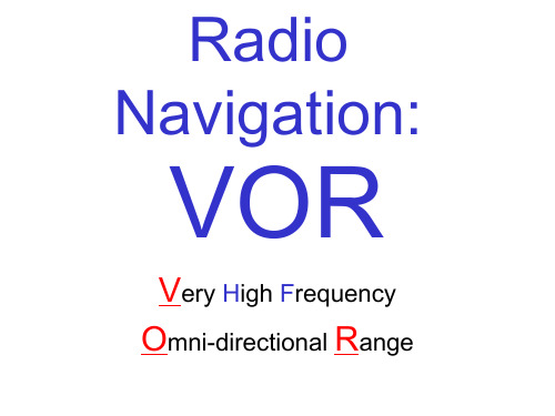
Radio Navigation:
VOR
Very High Frequency Omni-directional Range
VOR Navigation
Very High Frequency Omnidirectional Range (VOR)
Most common ground based navaid
Check TO-FROM window “TO”- selected course will take you generally
TO station “FROM”- selected course will take you generally FROM station
Identifying a Station
VOR VORTAC VOR/DME
108.00-117.95 MHz
VHF frequencies have “line of sight” limitation
VOR stations transmit radio beams, or Radials, which radiate outward FROM the station in every direction, like spokes on a wheel
Aircraft is located AWAY from needle Needle represents selected course line
Each dot is 2 degrees off course
5 dot sensitivity: 10 degrees full-scale deflection
Low Altitude VOR
40 n.m. 1,000 AGL - 18,000 AGL at altitudes > 18,000 AGL possible interference
High Altitude VOR
40 n.m. 1,000AGL- 14,500 AGL 100 n.m. 14,500 AGL - 18,000 AGL 130 n.m. 18,000 AGL – 45,000AGL 100 n.m FL 450 - FL 600
VOR – BASIC OPERATION
VOR GROUND STATION
IABLE SIGNAL
VOR – BASIC OPERATION
IN PHASE: REFERENCE-VARIABLE SIGNAL (360) OUT OF PHASE: VARIABLE SIGNAL (090) OUT OF PHASE: VARIABLE SIGNAL (180) OUT OF PHASE: VARIABLE SIGNAL (360-000)
CONE OF CONFUSION: over the station
ZONE OF AMBIGUITY: “ABEAM” the station The VOR will indicate “OFF” or “NAV” flag indications when over or abeam the station or when out of range and not receiving a reliable signal.
Station Passage
Close to the station Cone of confusion
VOR CLASSES/Standard Service Volumes
VOR classification in A/FD “radio aids to navigation”
AIM 1-1-8
Terminal VOR
Located at Airports for instrument approaches 25 n.m. 1,000AGL- 12,000 AGL
Pull “Volume/Ident” knob Listen to Morse Code Identifier Compare it to desired station on chart Wrong code - Wrong station No code - No station “TEST” ( _ . … _ ) code - Station under maintenance VOR code: approx. every 10 seconds DME code: approx. every 30 seconds
VOR RADIALS
VOR RADIALS vs. VOR COURSES
Navigation Procedures
Tune: select frequency Identify: listen to Morse code signal Navigate:
Select desired course on OBS Center needle to determine location
Interpreting VOR Indications
Needle centered with “FROM” in window
Aircraft is on radial OBS course Needle centered with “TO” in window Aircraft is on radial reciprocal to OBS course “FROM TOP - TO BOTTOM” Needle NOT centered (L or R of center)