凯立德移动导航系统用户手册(3.0)
Navigator 导航系统指南屏幕说明书
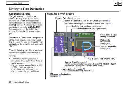
Guidance ScreenThe guidance screen offers an alternative way to view your route information. Many of the icons and screen features are similar to those on the map screen. While driving to your destination, press the MAP/GUIDE button to switch to the guidance screen. The guidance screen shows you:Milestone to Destination – the position of the small circular icon shows your trip progress. As you get closer to your destination, the indicator will approach “DEST.”Vehicle Heading – the black portion of the compass symbol indicates north. NOTE:• The map and voice guidance in unverified areas differ from those in verified areas.• Current maneuvers and those within 1000 feet will show on the Countdown bar, indicating the distance until the next maneuver.Guidance Screen Legend51)50)51)51)CURRENT STREET/AUDIO INFOCurrent Street (see page 6)(When audio information is displayed, touchAUDIO INFO. to display the current street name.) (see page 50)Driving to Your Destination50Navigation SystemDriving to Your DestinationDistance and Time to DestinationWhen you select a destination, the distance to the destination is the actual road distance of the calculated route, and “not as the crow flies.” When viewing a list of destinations (points of interest), such as restaurants, the distance is “as the crow flies” (see Sort by Distance to Travel on page 35).The displayed time to destination may differ from the actual travel time because the time is calculated based on the posted road speed data and your current speed. If part of your route includes unverified roads, the “distance” and “time to go” for that portion is estimated using 25 mph as an average speed.Direction ListWhen you press the MAP/GUIDEbutton on the guidance screen, thedisplay changes to:NOTE:• The map and voice guidance inunverified areas differ from those inverified areas. See Unverified AreaRouting on page 81.•Only maneuvers that occur atfreeway exits or contain freeway exitinformation will show the exit infoicon (“i” icon) on the right end of theitems in the direction list. If no exitinfo icon is shown on the list, the ExitInfo. is grayed out.You can see the directions list and thedistance to each maneuver. Press theMAP/GUIDE button to return to themap screen.You can scroll through the direction listby screen or by using the scroll bar, orone instruction at a time, using thejoystick.Navigation System 51。
凯立德移动导航系统使用手册

Q:如需要对本产品进行正版验证? A:请登录 的[产品正版验证]专区进行正
版验证。
Q:如需要进行系统升级? A:请登陆凯立德官方网站 的产品中心,
在地图主界面上点击【功能】>【帮助】,进入帮助功能菜单。
4
手势命令的使用
5 手势命令的使用
使用手势命令可快速实现如下功能,如“地图放大”、“地图缩小”、 “增大音量”、“减小音量”、 “去单位”、“回家”、“返航”。
在导航地图上,画一个手势动作,即可实现相应功能。
命令符号
命令画法方向
相应功能
竖直向上画一条直线 放大地图比例尺。
Q:凯立德移动导航系统只是用来导航的么? A:使用凯立德移动导航系统,不仅可以用来导航,还可以使用其中
的“智能周边检索”功能,来查找更多您想去的地方,例如餐厅、 酒店、加油站等等。具体操作如下:
点击【周边】。
选择您想查找的兴趣点类别即可。
Q:如果对凯立德我有其它问题要咨询? A:请致电凯立德客户服务电话:400-886-0118
快速入门
1 快速入门
第一步 启动系统 点击功能列表中移动导航系统图标,启动系统。
点击【接受】进入导航系统。
第二步 自动定位出发地
第三步 设定目的地
GPS 自动搜索卫星,自动定位出发 以将深圳市“世界之窗”设定为目
地。
的地为例。
导航仪接收到 3 颗或 3 颗以上卫星 信号时系统将自动定位当前所在地 为出发地 。
模拟导航.......................................................................... 13 查看行程说明 .................................................................. 14 取消导航路径 .................................................................. 14 记录行驶轨迹 .................................................................. 14 停止记录轨迹 .................................................................. 14 常用地点.......................................................................... 14 返航.................................................................................. 15
凯立德导航安卓零售版使用说明

凯立德【安卓零售版】使用说明一、界面和操作介绍:安卓零售版与车机的界面基本相同了,横屏显示,界面介绍如下(为便于介绍PS了下,后附具体说明):(一)浏览界面:1.路径规划:包括目的地、出发地、地址薄(家园版叫收藏夹),在导航状态下浏览地图时还会出现经由地选项。
此界面与浏览标(家园版叫光标了)、返回同时出现,需要在进入系统后或者在导航过程中长按屏幕(家园版为轻触)进入。
2.出发地、经由地(可选)和目的地:进入系统时只有车标和出发地或者代表当前位置的绿色圆点,在导航模式下才会出现目的地,如果有设置还会出现经由地。
3.指示栏:这里包括提示设置(可以选择安全、标准、简明三种提示方式)、地图模式设置(地图正北、图随车转、俯视图)和GPS指示。
4.电子眼:可以快速添加电子眼信息。
5.k码:进入k码显示和定位功能。
6.地图缩放和比例尺显示:比家园版多了个比例尺的显示。
7.底部菜单栏:包括功能(包含设置等,同家园版)、查找、常用(相当于家园版导航管理)、周边(快速查找目的地、导航路径、车标或浏览标周围的特定分类兴趣点)。
在它右边的三角箭头可以显示或者隐藏底部状态栏,再右边显示系统时间(导航模式下显示选路方式、剩余里程、剩余时间等信息)。
上方一点显示车标或者浏览标的地理位置(导航模式下还显示当地广播电台名称、频率)。
(二)导航界面:1.行程说明:进入行程说明界面,可以选择浏览或避开某一段路径。
2.目的地指示:显示目的地的名称。
3.复诵:点击可复诵上一次语音提示信息。
Ps:此图为俯视图模式,前方可以看得更远。
(三)操作介绍:1.地图移动:长按地图进入浏览模式,地图操作与家园版不同,移动地图时需点击目的位置,不支持地图拖拽。
2.定位:快速移动到该兴趣点所在位置,可以点击“上一个”、“下一个”定位到同列表中的其他兴趣点,也可以点击“周边”进入周边快速搜索。
3.改变位置和设定:进入浏览界面并定位到该兴趣点,移动地图到需要的位置后可以点击左侧的“设定”来完成对兴趣点的重新定位。
凯立德导航说明

一、说明本图片和文字实例来源于本人制作的2012年4月18日凯立德春季高清完美懒人包版C1567-M7A06-2821J0A,下载地址http://gg.ma/download_6064818.html1、进入Navione目录2、将DATA1.ZIP减压,将POI_DATA、NAVIMAP.CLD、NAVICODE.CLD、NAVIGDC.CLD、NAVIDIST.CLD、NAVIPOI.CLD复制到NaviOne3、将DATA2.ZIP减压,将NAVIBG.CLD复制到NaviOne4、将DATA3.ZIP减压,将CAMERA.CLD、NAVIROAD.CLD、NAVILID.CLD、NAVINOTI.CLD 复制到NaviOne5、删除DATA1、DATA2、DATA3目录和DATA1_ZIP.IDX,DATA2_ZIP.IDX,DATA3_ZIP.IDX6、进入POI-DATA目录,我只保留RDCRS43.CLD(湖南省)和POI-1.CLD(不能删除)。
兴趣点其他城市参见三7、删除NaviOne下的3d_ao.zip,3d_ao_ZIP.idx,navipoi.cld(周边查询)8、删除tatotblx.pak(地图热点联想资源文件)二、测试NaviOne减肥后只有1.78G,经模拟机测试使用正常,2012春季普清版和安卓全分辨率版可参照此方案。
三、兴趣点文件夹[POI_DATA]POI01.CLD RDCRS01.CLD 北京POI02.CLD RDCRS02.CLD 天津POI03.CLD RDCRS03.CLD 上海POI04.CLD RDCRS04.CLD 重庆POI13.CLD RDCRS13.CLD 河北POI14.CLD RDCRS14.CLD 山西POI15.CLD RDCRS15.CLD 内蒙POI21.CLD RDCR。
凯立德配置文件说明

20B0 2150 21F0 2290 2330 23D0 2470 2510 26F0
//是否将激活信息写到 HWINFO.cld 文件中
为 0:否,为 1:是
为 0:用 16 位色,为 1:用 24 为色
为 0:简体输入,为 1:繁体输入
//有些机器上计算声音播放的时间的不准,用这个变量来手动调整
100 米显示小路
0x34b0h (0 为禁用,1 为开启)
屏幕校准功能
(0 为禁用,1 为开启) (模拟器未能使用,真机测试也不一定能够使用,怀疑少某个文 0x3550 h 件或者程序)
TMC 功能
0x3910h (0 为禁用,1 为开启) 需主程序支持 TMC 功能
声音变大
初始化的时候是否设置出发地的名称,为空不设置
是否有退出导航系统功能,
为 0:否;为 1:是
是否有退出导航警告界面,
为 0:否;为 1:是
地图缓冲区大小
触摸屏连续移动的速度
键码移动地图的速度
鼠标松开后多长时间自动获取文字(ms)
是否删除自动激活文件,
为 0:不删除,为 1:删除
FD0 1070 1110 11B0 1250 12F0 1390 1430 14D0 1570 1610 16B0 1750 17F0 1890 1B10 1BB0
1C50 1CF0 1D90 1E30 1ED0 1F70 2010
是否需要 TTS,
=0:不需要,=1 需要
Байду номын сангаас地图初始 x位置
地图初始 y位置
凯立德配置文件说明:
凯立德导航使用说明

凯立德移动导航使用指南城市的道路建设以及汽车数量的增长十分之快,开着车穿梭于各大城市的朋友也越来越多,交叉如网状的道路相信会让不少开车的朋友迷茫不已。
正因为如此,有一个好的GPS全球卫星定位系统是很必要的。
今天我们就为大家介绍一下凯立德移动导航系统。
凯立德移动导航系统有两种安装方法,在选择了相应地区的地图及软件进行解压安装的时候程序会有提示,一种是通过同步的模式进行安装,另一种是将程序拷贝到存储卡上进行安装,两种安装方式由于安装文件即较大,数据线同步安装的方式过于缓慢,于是在安装的时候建议选用最快的存储卡安装方式(安装完成之后需创建一个快捷方式至程序菜单)。
不管采取何种安装方式,存储卡上必须有充足的空间,本次测试安装的是珠江三角洲地区的地图,所占的空间约为68M,如果要安装全国的导航地图则需要有一张剩余空间为512M以上的存储卡。
在程序安装完毕之后,首次运行时,输入根据每台手机唯一的设备识别码捆绑的激活码之后,即可开始正式使用凯立德移动导航系统了。
本次采用了GS-R232蓝牙GPS卫星接收机进行测试,体积小巧的卫星接收机适合放置在汽车的仸何位置,内置锂电池的设计,不仅适合车载使用,也适合在城市内的行走使用,内置的锂电池在全程GPS的定位使用下大概能够维持将近10个小时的使用。
长按GS-R232蓝牙GPS卫星接收机上的按键开启电源之后,接收机便自动进行卫星的寻找定位。
在空阔的地方,GS-R232的定位速度较快,大概在1~2分钟之内,而在高楼林立的城市内则需要3~5分钟的定位时间。
定位成功之后,长亮的橙色小灯则转为闪烁的状态。
在蓝牙GPS接收机成功的进行定位之后,开启凯立德移动导航软件,为了能够保障驾驶者的安全,软件会提示相关的注意事项,例如交通使用安全等事项。
按确认后即可进入程序的主运行界面,地图的界面便显示在屏幕上,默认坐标位置附近的建筑物或道路也会同时显示。
程序的地图有3种显示方式,分别为地图正北、随着行进方向旋转、以及鸟瞰图,用户可根据自己的习惯来进行选择,在使用的过程中,驾驶员则认为鸟瞰图的方式是最好的查看方式。
carlson sw 全站点 3 用户手册说明书

USER MANUALRevision: A2October 23th, 2020 v3Product OverviewThe BRx7 receiver is powered by the Athena RTK technology. The BRx7Audio Speaker5/8” Mounting holethe door as shown in Figure 2‐3.Figure 2‐6: Installing BRx7 on a tribrachFigure 2‐7: Range pole installationFigure 2‐8: External power connectorFigure 2‐9: 7‐pin diagnostic connector Figure 2‐10: Record folderlf you want this network to automatically connect, select the Connect automatically check box before pushing the Connect button. lf not, clickThe lnformation tab contains device and module information and current software and firmware versions.The Download tab allows you to log and review multiple data files from the on‐board memory of the device.Install New FirmwareThis feature allows you to update the menu application software. Once the correct software is selected under the Choose File browser, the Upload File button initiates the update procedure and re‐starts the BRx7 device. GNSS RegistrationGNSS Registration displays the expiration date of various subscription features on the BRx7.The Atlas expiration date will be displayed under this field. ln addition, the ability to update the BRx7 with new subscriptions is available under the AuthCode field. Type the new Atlas code and the device will automatically update.Radio Channel: Select a channel from the channel table provided by your dealer. The frequency, bandwidth, and transmit power (base only) is shown next to the channel.Radio Mode: The BRx7 supports PacCrest protocols (GMSK and 4FSK modulation), Satel protocols, and Trimtalk protocols. For a full list of protocols, with descriptions (FEC, Scrambling, over the air link rate, and modulation), please refer to Appendix C.The part numbers for the 5‐pin cable are as follows: BRx7 5‐pin cableslf configuring NTRIP for a Rover, click Get Mountpoint to generate a list of available mountpoints.WARNING: lf the BRx7 has not yet established an internet connection via the Internal GSM modem, the Get Mountpoint button will not operate. You can configure the APN settings while using TCP/IP so that an internet connection is established.To download the log, click the Download tab.All logs stored on the BRx7 internal hard drive will display.Multiple logs can be downloaded or deleted at one time by selecting the box next to each of the logs and clicking Package or Delete Selected. Satelliteslf you wish to exclude a specific satellite, select the Don’t track checkbox next to that satellite in the list.。
凯立德使用说明书

Careland®凯立德移动导航系统用户手册凯立德欣技术(深圳)有限公司二零零七年一月版权声明Careland®是凯立德欣技术(深圳)有限公司注册商标,受中华人民共和国商标法的保护,《凯立德移动导航系统用户手册》以及配套系统软件的版权属本公司所有,受中华人民共和国著作权法及知识产权法保护。
任何人及单位未经本公司授权许可,不得擅自侵占和使用Careland®商标,不得复制和仿造本手册及配套系统软件的全部或部分内容。
凯立德欣技术(深圳)有限公司二零零七年一月特别提示一、汽车行驶提示在汽车驾驶过程中查看导航系统屏幕,可能会导致严重的交通事故。
为了避免事故的发生,请在停车后操作此系统。
本系统内地图可能与实际路况有所不同,因此只作为参考之用,请在遵守实际交通规则的前提下使用本系统。
若因使用本系统而发生交通事故或其他任何事故,本公司将不负任何责任。
二、GPS信号接受提示在建筑物密集区和高架桥下行驶,以及天气变化或卫星信号关闭等因素,都可能影响GPS信号的接收,从而导致不能定位或定位不准、导航操作失败以及系统功能失常等现象的发生。
GPS是美国政府所有的全球卫星定位系统,本系统及本公司或其代理商不能每时每刻保证其定位精度。
三、操作说明操作时请您遵循相关移动设备的操作规则和要求,否则,会出现系统运行不正常或停止响应的情况,此情况下请关闭移动设备(如智能手机、掌上电脑),并重新启动系统。
目录一、系统功能简介 (1)二、系统启动 (1)三、地图画面按键功能说明和基本操作 (2)1 主要按键功能说明 (2)2快捷操作 (4)2.1地图缩放 (4)2.2地图漫游 (5)2.3地图视图模式快速切换 (5)2.4快速查看GPS信息 (5)2.5快速设置音量 (6)2.6快速指定目的地、出发地 (6)2.7快速存入地址簿 (7)2.8查看行程说明 (10)四、系统主要功能 (10)1 地图视图设置 (11)1.1 地图正北 (11)1.2 图随车转 (12)1.3 鸟瞰方式 (12)2 路径规划 (13)3 地址簿管理 (14)3.1查看 (15)3.3删除 (23)3.4编辑 (23)3.5导入 (24)3.6导出 (26)4路径管理 (27)4.1行程说明 (27)4.2模拟行驶 (28)4.3取消路径 (28)5轨迹管理 (29)5.1导航 (30)5.2回放 (31)5.3删除 (31)5.4改色 (32)5.5改名 (32)5.6浏览 (33)5.7导出 (34)5.8导入 (34)6 辅助功能 (36)6.1调整车头方向 (36)6.2GPS信息 (37)6.3版本信息 (37)7系统参数 (38)7.1画面设置 (38)7.2语音设置 (42)7.4搜索条件设置 (43)7.5地址簿提示设置 (45)7.6超速设置 (45)7.7GPS设置 (46)7.8系统初始化 (48)8关闭导航系统 (49)9查找 (49)9.1默认检索 (50)9.2交叉路口检索 (53)9.3先前目的地 (55)9.4智能周边检索 (56)9.5按当前光标位置设定 (58)9.6分类检索 (59)9.7地址簿检索 (61)9.8城市中心检索 (62)9.9国家级景点检索 (64)六、在路径导引过程中画面的显示模式 (65)七、语音提示 (66)1 交叉路口或出入口的语音提示 (66)2 高架路、高速公路的语音提示 (67)3 接近目的地及经由地时语音提示 (67)4 随时语音提示 (67)免责声明 (68)一、系统功能简介凯立德移动导航系统是一种运行于车载导航仪、便携式导航仪和智能手机等移动智能设备上的应用软件系统,它是利用GPS卫星信号接收器将移动智能设备位置进行精确自主定位,并显示在导航电子地图上,用户设定目的地后,系统会自动计算出一条最佳路径,同时在行进过程中会有自动语音提示,帮助用户安全、快捷地到达目的地。
凯立德导航软件使用说明

凯立德手机导航软件v3.02最新版下载说明0907凯立德, 手机, 软件, 导航, 下载新数据、新引擎、新功能、新设计、全新地图,凯立德手机导航软件将再次引领新一轮的手机导航流行风潮。
2009年7月初,凯立德手机导航软件又进行了一次大的版本升级,目前最新版本已经升级到V3.02。
此次更新后的软件版本将广泛的适用于Symbian S60V3、Windows Mobile 5.0/6.0/6.1及以上系统且具备GPS导航功能的大部分手机和部分Linux导航手机。
下载方式:请登录/down.php,进入以后选择自己的机型就可以下载了。
因为专业,所以心系关怀作为中国GPS导航软件第一品牌的凯立德,在导航领域的10年发展,其产品的专业性已经被广大用户所认可,所获得的各种奖项更是被业内人士所肯定。
此次发布的凯立德手机导航软件产品在之前众多产品的基础上除了为用户提供了更加专业的电子地图和导航功能外,软件的操作也更加人性化,无处不体现着软件对用户的关怀以及对用户真正需求的满足。
全功能全覆盖的免费贴身电子地图此次的版本升级,凯立德手机导航软件不仅为广大用户提供了基础导航数据的免费升级下载服务,同时还大范围的扩充了电子地图的兴趣点(POI)信息,为广大导航用户提供覆盖全国路网和包含750万个以上精确兴趣点(POI)的电子地图。
道路总里程200万公里,含括4个直辖市,33个省级行政区域(包含香港、澳门)以及25个省会城市,333个地级市,2862个县级行政单位,3万个乡镇级行政单位,部分沿海城市及经济发达地区,基本实现村村通。
软件本身还提供基于电子地图的免费地图浏览功能、快速查找目的地和兴趣点(POI)功能,极大的丰富了导航类手机软件的功能。
专业导航按需付费此次升级的凯立德手机导航软件为用户提供免费下载获取,免费导航服务,每次语音导航收取人民币2元的导航服务费用(不含GPRS流量费),不导航不收费。
相比众多的PC和PND (便携式自导航系统)导航软件几百元甚至上千元的导航费用来说可谓是为用户极大的节约了使用费用。
导航系统3简介手册说明书
3Manual OverviewThe manual is divided into the following sections:System OverviewThe navigation system applies this location,direction, and speed information to the maps and calculates a route to thedestination you enter. As you drive to that destination, the system provides map and voice guidance.The navigation system is easy to use. The locations of many places of business and entertainment are already entered in the system. You can select any of them as a destination by using the touch screen or voice control.There are several ways to enter adestination, such as by point of interest (POI), by address, by phone number, and by selecting it from the map. The last 50destinations are saved for reuse at a later date. The system also allows you to store a home address to simplify returning home from your destination.Accessories PrecautionsIf you have rear window tintinginstalled, be aware that if the tint has metallic properties, it can seriously degrade or prevent GPS reception. This is because the GPS antenna is located under the rear window beneath the package tray.Y our navigation system is a highly-sophisticated location system with voice control that uses satellites and a mapdatabase to show you where you are and to help guide you to a desired destination.If you plan to install electroniccomponents such as vehicle location devices, remote starters, additional amplifiers, or other audio components ensure that they are not located near the navigation control unit in the trunk, or near the navigation display in the dash. Signal noise emanating from these devices can cause intermittent disruption of the navigation system.•that discusses the controls and how to communicate with the system.•address or locate a point of interest (POI).•explanation of the map features,guidance, and cautions.••System Set-up - How to set up and tailor the system for your personal use and add Personal Addresses.The back of this manual contains:•Frequently Asked Questions (FAQs)•Getting Started - A basic introduction Entering a Destination - How to enter an Driving to your Destination – An Information Features - Trip Computer,V oice Help, Calendar, and Calculator.•Troubleshooting Guide Glossary of Terms •V oice Command ListThe navigation system receives signals from the global positioning system (GPS),a network of 24 satellites in orbit around the earth. By receiving signals from several of these satellites, the navigation system can determine the latitude, longitude, and elevation of your vehicle. In addition, a a gyroscopic yaw sensor and a vehicle speed sensor in your vehicle keep track of the direction and speed of travel at all times.4Important Safety InformationThe navigation system can distract your attention from the road if you focus on the screen or operate the system’s controls while driving.Enter as much information as possible into the system before you begindriving, or when the vehicle is stopped.Then, as you drive, listen to the audio instructions and use voice commands when possible.While driving, do not look at the screen or operate the system controls for more than a second or so at a time, and only after deciding you can do so safely.Pull to the side of the road if you need more time to look at the screen or operate the controls.The navigation system is designed to provide route information to help you reach your destination. However, this route guidance may sometimes conflict with current road conditions such as street closures, road construction,detours, and out-of-date map data.Additionally, the system itself has certain limitations (see page 65).Therefore, you must verify the audio and visual route information provided by the system by carefully observing the roadway, signs and signals, etc. If you are unsure, proceed with caution.Always use your own good judgment,and obey traffic laws while driving.Map OverviewYour navigation system has two kinds of streets: verified (dark colored) and unverified (light colored). Thedifferences between the two types of streets are contrasted in the followingchart.Introduction“Verified” Road5When displayedStreet color Map QualityRouting differences CautionsGuidance voice Time and distance “to go”Verified streets (dark colored)These roads are found within metropolitan areas, and include interstate freeways and major roads connecting cities.Shown on daytime map screen as black or red, such as interstate freeways.The database vendor has verified these streets.Information like turn restrictions, average speed, and whether it is a one way street have been gathered and used when creating your route to a destination.While driving to your destination, the displayed route line is solid blue. The system provides voice and map guidance to your destination.There are no pop up boxes urging extra caution during a route. However, because roads constantly change, you are urged to use common sense, and always obey posted traffic restrictions.V oice guidance issues maneuvers such as “In a half mile make a right turn.”The time and distance “to go”, displayed while en-route to a destination, is based on the average speed and distance for the roads used for your route.Unverified streets (light colored)These roads are found in rural areas, and typically include residential streets away from the center of a town.Shown on the daytime map screen as light brown.Your route line is either a blue dotted “vector line”, or a dashed pink/blue line. See the Set-up section “unverified routing” for information on selecting this option, and the routing differences.Regardless of whether the user chooses route guidance, there are cautionary screens before and during the route urging the user to be extra cautions, and obey all traffic restrictions. See the Unverified Routing on page 39.The suffix “if possible” is added to each guidance maneuver.For example: “In a half mile make a right turn, if possible.” Because the average speed of these roads is not known, the time and distance “to go” is based on a fixed average speed of 25 mph for these roads.These streets have not been verified by the database vendor. The system does not contain information about one-way streets, turn restrictions, or the road’s average speed. They are shown on the map for reference and can have errors in map location, naming, and address range.。
凯立德导航说明手册
对地点进行查找过后都会有输入历史记录,令人遗憾的是,选择输入某一个输入历史(例如TPY)时并没有出现用户上一次的选择结果,而是再次推荐排序,这一点不够人性化。
查找结果
以输入"TPYS"为例,系统自动推荐"太平洋(601099,股吧)数码广场",点击即可进入下一级菜单界面。(Tips:这里有个小技巧,点击键盘收缩/展开按钮可对结果进行快速筛选。)凯立德导Βιβλιοθήκη 系统界面介绍凯立德系统界面
打开凯立德后即进入导航界面,大家都再熟悉不过了,大家都知道有完整了解过其界面功能吗?接下来对其系统界面进行简单分析。位于下部的菜单缩放按键,点击即可对凯立德导航界面菜单进行隐藏/打开,长时间无操作即自动隐藏。
语音提示设置
首先看下位于右上角这一侧的三个功能按键,分别为:语音设置、视角选择、卫星信号状态。语音设置中可对导航语音提示进行详细设置。
在地址薄查找中主要是通过前期对地址薄的管理来快速查找地址,也就是相当于手机名片的功能。
历史查找
而历史查找则相对快捷方便许多,它能够根据时间顺序排列地点搜索历史,点击即可直接导航。
城市查找
城市查找中需要注意的是在本地进行异地查找,先选择该异地城市再进行目的地查找,会更有效率、更加准确。常常听朋友说在广州市查找某外地公司,只有广州市的搜索结果,问题就是出在这里,值得注意。
向导提示框设置
此外如果觉得导航步骤太繁琐,在向导提示设置中可对个人习惯进行个性化设置,即可省去许多设置步骤,从此一劳永逸。
手势说明
凯立德还提供了7种手势导航,这3种是比较常用的,不过没办法对手势进行自定义,不够人性化,希望后期能改进。其中"单位"和"家"等地点设置可在"常用地点"中添加。
凯立德导航助手操作指南
目录目录一、什么是「凯立德导航助手」 (2)二、导航助手的获取与安装 (2)三、导航助手的注册与登录 (3)四、设备的连接 (4)五、管理我的设备 (5)六、设备的升级 (5)升级步骤一 下载安装 (5)升级步骤二 确认设备信息 (9)升级步骤三 购买激活码 (10)七、设备的备份/还原 (12)八、地址簿与轨迹的上传/下载 (12)九、导航助手的设置 (13)设置菜单一 (13)设置菜单二 (14)凯立德凯立德导航导航导航助助手教程教程感谢您使用「凯立德导航助手」,请您仔细阅读本教程,这将有助于您更熟练的使用导航助手,体验到更为专业的凯立德导航服务。
一、什么是「凯立德导航助手」「凯立德导航助手」是一款安装在桌面电脑上的软件,当您把导航设备或者装有导航软件的存储卡与电脑连接后,您可以通过导航助手在电脑上实现以下功能:1)一键式、智能化升级凯立德导航系统,升级及时、方便、快捷;2)一键“备份”、“还原”导航系统文件:导航系统安全无忧,即使您不小心删除系统文件,也能让您正常恢复导航;3)在线管理地址簿、轨迹:实时链接导航设备与凯立德家园,并在线管理这些个人位置信息。
「凯立德导航助手」操作简易,功能实用,彻底为您解决导航升级难问题。
二、导航助手的获取与安装从凯立德家园/tempDown/KLDdhzs.exe 下载「凯立德导航助手」安装文件。
双击导航助手安装文件,弹出「凯立德导航助手」安装向导,根据向导提示操作,完成导航助手的安装。
三、导航助手的注册与登录在电脑桌面双击「凯立德导航助手」软件图标或者在电脑开始菜单栏点击,开启软件。
「凯立德导航助手」登录的账号/密码与凯立德家园网的账号/密码互相通用。
如果您已有凯立德家园的账号/密码,直接输入后点击「登录」即可登录导航助手。
如果您没有凯立德家园网账号/密码,点击「立即注册」,进入导航助手注册界面。
输入注册信息后,点击「注册」。
注册成功后,您可以使用该用户名和密码,登陆凯立德家园网及「凯立德导航助手」。
凯立德导航设置

8、将地图卡再次插入导航仪
9、打开导航仪 —— 进入设置选项 —— 导航设置 —— 导航软件路径 —— 选择存储卡内DSA-P57文件夹中的DSA.EXE文件 —— 保存退出。
10、关闭导航仪
11、打开导航仪 —— 运行GPS功能,此时屏幕应该显示为DSA善领驾驶系统
12、选择DSA驾驶系统主页面右下角的系统设置 —— 其他设置 —— 端口设置 —— 将GPS端口号和波特率更改为步骤5中记录下的端口号和波特率 —— 设置虚拟端口号为COM9,与步骤7中设置的一样 —— 保存退出
4、关闭导航仪
5、再次开启导航仪 —— 运行GPS功能 —— 白屏,左上角或屏幕中间位置开始测试导航仪系统参数,包括:屏幕分辨率、端口号、波特速率 —— 当屏幕数字静止时(通常会显示扫描已完成),记下相应数据备用。
6、关闭导航仪
7、将地图存储卡重新连接电脑 —— 进入NaviOne文件夹 —— 进入NaviResFile文件夹 —— 运行kld_conf文件 —— 配置文件选择NaviOne\NaviResFile\NaviConfig.dll —— 将端口设置为COM9,波特率为刚才扫描检测到的波特率。其他数据尽量不要更改。
13、再次运行导航仪的GPS功能,此时会进入DSA驾驶系统主页面 —— 这个页面可以更改,有多个自带的个内置页面可供选择 —— 同样,汽车品牌图标也可通过点击任意更改成自己喜欢的厂家图标 —— 运行屏幕中下方的导航选项 —— 此时进入凯立德3D导航。
14、注意:每次想运行导航时,都要先运行DSA善领驾驶系统后,才可以运行凯立德。如果只想运行凯立德,那么请删除存储卡内的DSA-P57文件夹,按照以上方法重新进行硬件测试,更改NaviConfig.dll数据,端口号依旧设置为COM9,然后在凯立德导航的设置里设置其他选项,端口号和波特率为检测到的数据,虚拟端口号设置为COM9。即可。
Navigator GPS导航系统说明书
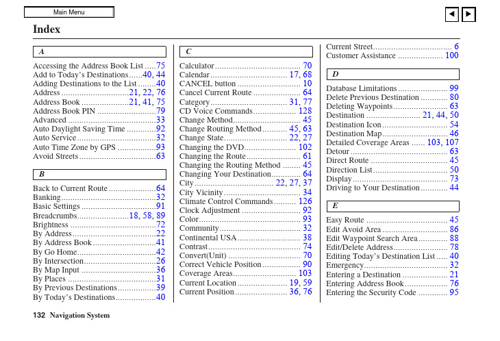
AAccessing the Address Book List (75)Add to Today’s Destinations......40, 44 Adding Destinations to the List.. (40)Address..............................21, 22, 76 Address Book .....................21, 41, 75 Address Book PIN.. (79)Advanced (33)Auto Daylight Saving Time (92)Auto Service (32)Auto Time Zone by GPS (93)Avoid Streets (63)BBack to Current Route (64)Banking (32)Basic Settings (91)Breadcrumbs.......................18, 58, 89 Brightness.. (72)By Address (22)By Address Book (41)By Go Home (42)By Intersection (26)By Map Input (36)By Places (31)By Previous Destinations (39)By Today’s Destinations (40)C Calculator (70)Calendar.................................. 17, 68CANCEL button (10)Cancel Current Route (64)Category.................................. 31, 77CD Voice Commands (128)Change Method (45)Change Routing Method........... 45, 63Change State............................ 22, 27Changing the DVD (102)Changing the Route (61)Changing the Routing Method (45)Changing Your Destination (64)City................................... 22, 27, 37City Vicinity (34)Climate Control Commands (126)Clock Adjustment (92)Color (93)Community (32)Continental USA (38)Contrast (74)Convert(Unit) (70)Correct Vehicle Position (90)Coverage Areas (103)Current Location...................... 19, 59Current Position....................... 36, 76Current Street (6)Customer Assistance (100)DDatabase Limitations (99)Delete Previous Destination (80)Deleting Waypoints (63)Destination ........................ 21, 44, 50Destination Icon (54)Destination Map (46)Detailed Coverage Areas ...... 103, 107Detour (63)Direct Route (45)Direction List (50)Display (73)Driving to Your Destination (44)EEasy Route (45)Edit Avoid Area (86)Edit Waypoint Search Area (88)Edit/Delete Address (78)Editing Today’s Destination List (40)Emergency (32)Entering a Destination (21)Entering Address Book (76)Entering the Security Code (95)132Entering the Street Number (26)Entering Your Schedule (69)Error Message (119)Exit Info (51)FFind Place Commands (125)Frequently Asked Questions (112)GGetting Started (10)Global Commands (123)Glossary (120)Go Home..................................21, 42 Go Home PIN...........................42, 80 Going Off the Route (58)GPS Initialization (96)Guidance Mode (89)Guidance Prompts.....................47, 74 Guidance Screen .. (49)HHome Address (78)Hotel/Motel (Lodging) (32)IIcon Bar (56)INFO button ............................ 10, 66 Information (66)Information Screen Voice Commands (128)Intersection.............................. 21, 26J Joystick (11)KKey to Zagat Ratings (71)Keyboard Layout (91)LLandmark Icons (54)Leisure (32)Lodging (Hotel/Motel) (32)MMap Color (93)Map Coverage (103)Map Input................................ 21, 36Map Legend....................... 18, 48, 68Map Matching (96)Map Orientation (53)Map Scale (52)Map Screen........................ 18, 46, 48MAP/GUIDE button................. 10, 49Maximize Freeways (45)MENU button .......................... 10, 21Menu Color (94)Message (69)Microphone (12)Minimize Freeways (45)Minimize Toll Roads (45)NName ................................ 31, 35, 76NAVI BACK button (12)NAVI Talk button (12)Navigation Display Commands (124)Navigation General Commands (123)OOff-road Tracking .................... 58, 89On-Screen Commands (130)On-Screen Commands Assist (130)On-Screen Keyboard (15)133PPC Card (102)Personal Information (75)Phone Number....................31, 35, 77 PIN Number.. (79)Place Name ..............................33, 35 Place Name by Keyword.. (33)Places.................................21, 31, 77 Previous Destinations....21, 39, 77, 80RRadio Voice Commands (127)Read List..................................32, 68 Recalculation. (81)Reporting Errors (100)Rerouting (81)Restaurant (32)Route ...........................44, 46, 58, 61 Routing & Guidance (81)Routing Method (45)SSave Current (59)Schedule (69)Schedule List (69)Screen............................................11Search Waypoint on Route.. (61)Security Code (95)Selecting the City..................... 22, 27Selecting the State or Province.. 22, 27Selecting the Street................... 24, 29SET UP button (11)Setup Screen (first) Commands (129)Shopping (33)Show Icons on the Map (54)Sort by Distance to Travel (33)Split Screen Guidance (51)State.................................. 22, 27, 37 Street....................................... 24, 29System Controls (10)System Function Diagram (20)System Information (91)System Initialization (95)System Limitations (97)System Set-up (72)System Start-up (16)TTemperature Voice Commands (127)Time Adjustment (93)Title (69)Today’s Destination List (40)Today’s Destinations................ 21, 40 Travel.. (33)Trip Computer (66)Troubleshooting (119)UUnit Conversion (70)Units (mile or km) (91)Unverified Area Routing........... 82, 83Unverified streets (7)Update DVD (101)User Name (80)Using the Voice Control System (13)VVehicle (89)Verified streets (7)View Routes (45)Voice (91)Voice Command Help (67)Voice Command Index (123)Voice Control Basics (12)Voice Recognition Feedback (91)Voice Recognition, Improving (13)Volume (72)WWaypoints ............................... 61, 88134ZZOOM buttons (11)135。
TANKEGPS导航软件专版用户手册3
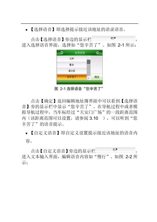
●【选择语音】即选择提示接近该地址的语录语音。
点击【选择语音】旁边的显示栏,进入选择语音界面,选择如“您辛苦了”。
如图2-1所示:图2-1选择语音“您辛苦了”点击【确定】返回编辑地址簿界面中可以看到【选择语音】旁的显示栏中显示“您辛苦了”。
在导航过程中或者模拟导航过程中,当车标经过“天安门广场”的一段距离范围内(该距离范围可以设置,请参阅3.10 ),可以听到“您辛苦了”的语音提示。
●【自定义语音】即自定义设置提示接近该地址的语音内容。
点击【自定义语音】旁边的显示栏,进入文本输入界面,编辑语音内容如“慢行”。
如图2-2所示:图2-2编辑语音内容“慢行”点击【确定】进入编辑地址簿界面,可以看到【自定义语音】旁边的显示栏中显示“慢行”。
在导航过程中或者模拟导航过程中,当车标经过“天安门广场”的一段距离范围内(该距离范围可以设置,请参阅3.10 ),可以听到“慢行”的语音提示。
注:【选择语音】与【自定义语音】二者只能设置其中一项。
●【改变位置】即修改该地址在地图上的位置。
点击【改变位置】,进入地图界面,移动浏览标至所需位置,如图2-3所示图2-3移动浏览标至所需位置点击【设定】,返回到编辑地址簿界面。
●【设置标示图标】设置该地址在地图界面上的标示图标。
在地址簿编辑界面的标示图标部分选中某一图标如,如图2-4所示。
图2-4选择图标步骤1 点击【确定】保存步骤2中所做的更改设置。
2. 删除被保存的地址操作步骤如下:步骤1 点击【功能】>【地址簿】,选择需删除的地址所在组别,如“休闲娱乐”,点击【查看】,进入地址簿分组管理界面,如图 2-5所示:图2-5“休闲娱乐”地址簿分组管理步骤2 选择需要删除的地址,如“天安门广场”。
点击【删除】(如果选择【全删】则删除的整个分组中的地址),弹出确认删除提示框。
如图 2-6所示:图2-6确认删除提示框选择【确认】,则选中的地址被删除;选择【取消】,则中断删除操作。
导航系统3简介用户手册说明书
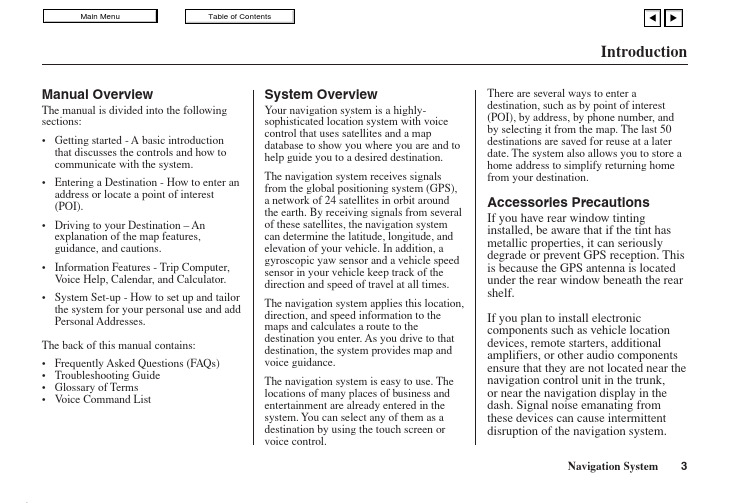
IntroductionManual OverviewThe manual is divided into the following sections:•Getting started - A basic introduction that discusses the controls and how tocommunicate with the system.•Entering a Destination - How to enter an address or locate a point of interest(POI).•Driving to your Destination – An explanation of the map features,guidance, and cautions.•Information Features - Trip Computer, V oice Help, Calendar, and Calculator.•System Set-up - How to set up and tailor the system for your personal use and add Personal Addresses.The back of this manual contains:•Frequently Asked Questions (FAQs)•Troubleshooting Guide•Glossary of Terms•V oice Command List System OverviewYour navigation system is a highly-sophisticated location system with voicecontrol that uses satellites and a mapdatabase to show you where you are and tohelp guide you to a desired destination.The navigation system receives signalsfrom the global positioning system (GPS),a network of 24 satellites in orbit aroundthe earth. By receiving signals from severalof these satellites, the navigation systemcan determine the latitude, longitude, andelevation of your vehicle. In addition, agyroscopic yaw sensor and a vehicle speedsensor in your vehicle keep track of thedirection and speed of travel at all times.The navigation system applies this location,direction, and speed information to themaps and calculates a route to thedestination you enter. As you drive to thatdestination, the system provides map andvoice guidance.The navigation system is easy to use. Thelocations of many places of business andentertainment are already entered in thesystem. You can select any of them as adestination by using the touch screen orvoice control.There are several ways to enter adestination, such as by point of interest(POI), by address, by phone number, andby selecting it from the map. The last 50destinations are saved for reuse at a laterdate. The system also allows you to store ahome address to simplify returning homefrom your destination.Accessories PrecautionsIf you have rear window tintinginstalled, be aware that if the tint hasmetallic properties, it can seriouslydegrade or prevent GPS reception. Thisis because the GPS antenna is locatedunder the rear window beneath the rearshelf.If you plan to install electroniccomponents such as vehicle locationdevices, remote starters, additionalamplifiers, or other audio componentsensure that they are not located near thenavigation control unit in the trunk,or near the navigation display in thedash. Signal noise emanating fromthese devices can cause intermittentdisruption of the navigation system.Important Safety Information The navigation system can distract your attention from the road if you focus on the screen or operate the system’s controls while driving.Enter as much information as possible into the system before you begin driving, or when the vehicle is stopped. Then, as you drive, listen to the audio instructions and use voice commands when possible.While driving, do not look at the screenor operate the system controls for morethan a second or so at a time, and onlyafter deciding you can do so safely.Pull to the side of the road if you needmore time to look at the screen oroperate the controls.The navigation system is designed toprovide route information to help youreach your destination. However, thisroute guidance may sometimes conflictwith current road conditions such asstreet closures, road construction,detours, and out-of-date map data.Additionally, the system itself hascertain limitations (see page 65).Therefore, you must verify the audioand visual route information providedby the system by carefully observingthe roadway, signs and signals, etc. Ifyou are unsure, proceed with caution.Always use your own good judgment,and obey traffic laws while driving.Map OverviewYour navigation system has two kindsof streets: verified (dark colored) andunverified (light colored). Thedifferences between the two types ofstreets are contrasted in the followingchart.Introduction“Verified” RoadIntroductionWhen displayed Street color Map QualityRouting differences CautionsGuidance voice Time and distance “to go”Verified streets (dark colored)These roads are found within metropolitan areas, and include interstate freeways and major roads connecting cities.Shown on daytime map screen as black or red, such as interstate freeways.The database vendor has verified these streets.Information like turn restrictions, average speed, and whether it is a one way street have been gathered and used when creating your route to a destination.While driving to your destination, the displayed route line is solid blue. The system provides voice and map guidance to your destination.There are no pop up boxes urging extra caution during a route. However, because roads constantly change, you are urged to use common sense, and always obey posted traffic restrictions.V oice guidance issues maneuvers such as “In a half mile make a right turn.”The time and distance “to go”, displayed while en-route to a destination, is based on the average speed and distance for the roads used for your route.Unverified streets (light colored)These roads are found in rural areas, and typically include residential streets away from the center of a town.Shown on the daytime map screen as light brown.These streets have not been verified by the database vendor. The system does not contain information about one-way streets, turn restrictions, or the road’s average speed. They are shown on the map for reference and can have errors in map location, naming,and address range.Your route line is either a blue dotted “vector line”, or a dashed pink/blue line. See the Set-up section “unverified routing” for information on selecting this option, and the routing differences.Regardless of whether the user chooses route guidance, there are cautionary screens before and during the route urging the user to be extra cautious, and obey all traffic restrictions. See the Unverified Routing on page 39.The suffix “if possible” is added to each guidance maneuver.For example: “In a half mile make a right turn, if possible.” Because the average speed of these roads is not known, thetime and distance “to go” is based on a fixed average speed of25 mph for these roads.User AgreementIn using this DVD “Satellite Linked Navigation System” (the “DVD”), which includes HONDA MOTOR CO., LTD. software, ALPINE ELECTRONICS, INC. software,NA VIGATION TECHNOLOGIES CORPORATION database contents and INFO USA CORPORATION database contents (hereinafter referred to as “Licensors”), you are bound by the terms and conditions set forth below. By using your copy of the DVD, you have expressed your agreement to the terms and conditions of this agreement. You should, therefore, make sure that you read and understand the following provisions. If for any reason you do not wish to be bound by the terms of this agreement, please return the disk to your Acura dealer.•The DVD may not be copied,duplicated, or otherwise modified, inwhole or in part, without the expresswritten permission of the Licensors.•The DVD may not be transferred orsublicensed to any third party forprofit, rent or loan, or licensed forreuse in any manner.•The DVD may not be decompiled,reverse engineered or otherwisedisassembled, in whole or in part.•The DVD may not be used in anetwork or by any other manner ofsimultaneous use in multiplesystems.•The DVD is intended solely forpersonal use (or internal use wherethe end-user is a business) by theconsumer. The DVD is not to beused for commercial purposes.•The Licensors do not guarantee tothe customer that the functionsincluded in the DVD meet thespecific objectives of the user.•Licensor shall not be responsible forany damages caused by the use ofthe DVD to the actual user or to anythird party.•The warranty on the DVD shall notextend to an exchange or refund dueto misspelling, omission of letters, orany other cosmetic discrepancy inthe layout of the DVD.•The right to use the disk shall expireeither when the user destroys theDVD or software, or when any of theterms of this agreement are violatedand the Licensors exercise the optionto revoke the license to use the DVDor software.User Agreement•The terms and conditions hereof apply to all subsequent users and owners as well as to the original purchaser.•The use of oil company logos in the display are for your information and convenience, and in no way implies any sponsorship, approval or endorsement of these companies, or their products. The logos are trademarks of their respective owners.The user shall indemnify and save harmless the Licensors, and their officers, employees and agents, from and against any claim, demand or action, irrespective of the nature of the cause of the claim, demand or action, alleging loss, costs, expense, damages or injuries (including injuries resulting in death) arising out of the use or possession of the DVD, data, or the Navigation Technologies Corporation e, duplication, or disclosure of this DVD by or on behalf of the United States government is subject to “Restricted Rights” as set forth at FAR 52.227-14, -19 or DFARS 252.227-7013, as applicable. Manufacturers are the Licensors, including HONDA MOTOR CO., LTD., 2-1-1 Minami Aoyama Minato-Ku Tokyo 107-8556 JAPAN., Alpine Electronics, Inc., 20-1 Yoshima Kogyodanchi, Iwaki, Fukushima 970- 1192 JAPAN., Navigation Technologies, 10400 W. Higgins Rd., Rosemont, IL 60018 and INFO USA CORPORATION, 5711South 86th Circle, Omaha, NE 68127.。
- 1、下载文档前请自行甄别文档内容的完整性,平台不提供额外的编辑、内容补充、找答案等附加服务。
- 2、"仅部分预览"的文档,不可在线预览部分如存在完整性等问题,可反馈申请退款(可完整预览的文档不适用该条件!)。
- 3、如文档侵犯您的权益,请联系客服反馈,我们会尽快为您处理(人工客服工作时间:9:00-18:30)。
8.8调整车标方向 54
8.9查看GPS信息 54
8.10版本信息 55
8.11地图视图 55
8.12查看激活信息 56
第九章 语音播报说明 58
附 录 输入法说明 59
有限保证 62
版权声明 63
第一章 系统的初次使用
凯立德移动导航系统还为您提供了详细的生活资讯,无论身在何地,都可以像当地人一样了解该地的餐厅、超市、银行网点、小区等生活信息。
我们为您提供精准丰富的地图数据和及时的更新、升级服务。界面人性化的设计和多种功能带给您舒适的操作和乐趣:
* 轨迹记录、重放可实际导航,还可以和好友交换使用
* 自由设置新的兴趣点,还可以和好友交换使用
第七章 地址簿 39
7.1查看、管理地址 39
7.1.1查看地址 39
7.1.2添加新地址 39
7.1.3删除地址 41
7.1.4全删某组地址 41
7.1.5地址定位 41
7.1.6编辑地址 42
7.2组别管理 44
7.2.1添加新组 44
1.3 GPS设置
注:如果GPS接收器已经与导航仪绑定,则无需设置GPS。
1.3.1 外接蓝牙设置(以多普达ppc为例)
1. 打开GPS蓝牙接收器。
2. 点击【开始】,在下拉菜单中点击【设置】,再点击【连接】:
3. 点击【蓝牙】图标,进入蓝牙设置画面,设置蓝牙,并使其为打开状态,点击【设备】,进入添加新设备画面:
设备特征码为:2324123456781235;
刮开的快乐绿卡-授权卡上的授权号为:1121112111211121。
在实际激活过程中,请您根据您的实际情况进行操作。
1. 点击【凯立德移动导航系统】图标,进入导航系统,系统弹出激活系统画面,显示软件的【版本号】与机器的【设备特征码】。
③ 通过功能﹥路径规划(见第四章路径规划)设定目的地(还可设定经由地和回避地)。
设置好目的地,系统自动选路后,地图上会以粉红色线条显示系统推荐路径。
2.1.3关闭导航系统
点击【功能】,进入功能画面,点击【关闭导航系统】图标,系统弹出对话框后,点击【否】,返回功能画面;点击【是】,关闭导航系统。
7.2.2删除组别 45
7.2.3编辑组别名称 45
7.2.4导入地址 46
7.2.5导出地址 47
第八章 高级功能 48
8.1画面设置 48
8.2语音设置 50
8.3周边设施搜索范围 51
8.4搜索条件设置 51
8.5超速设置 52
8.6地址簿提示距离 53
3. 如果为网上激活,请登陆凯立德官方网站,进入“产品中心”的“会员激活”专区(或根据激活提示中的提示直接登陆网址:/Card/ActiveNo.htm),刮开快乐绿卡【授权码】的覆盖层获取用户【授权码】,在网站上正确的填写好【授权码】和【设备特征码】以及其它必填客服信息在线获取【激活码】。
2.2地图主界面
图 标 含 义 说 明 表
标 号 含 义 标 号 含 义 1 指北针 11 音量 2 GPS状态 12 放大地图 3 地图比例尺 13 缩小地图 4 下一个转向方向和距离 14 将当前光标所在地点设为目的地 5 将驶入道路的名称 15 将当前光标所在地点设为出发地 6 离目的地剩余距离,点击可查看行程说明 16 将当前光标所在地点存入地址簿 7 GPS信号当前时间 17 光标所在点路名 8 查找兴趣点 18 返回导航地图画面 9 系统功能 19 查找周边设施 10 播报当前语音提示
7. 如需升级或咨询,请与经销商联系或拨打400-8860118。
8. 针对每一套硬件载体本公司仅提供一套产品和一个授权码,请您妥善保管和使用相关硬件。因硬件的丢失或故障原因而造成导航系统不可继续使用的,本公司概不负责。
9. 本套手册中所述内容仅作为介绍功能操作所用,因软件不断升级变化,实际使用中请以实物为准。
9. 接着在导航系统中设置GPS,以连接导航系统与GPS接收设备(只需在初次运行系统时需设置GPS,如果不更换GPS蓝牙接收设备,以后每次使用不再重新设置)。在地图画面上点击【功能】按钮,进入功能画面,点击【系统参数】图标,进入系统设置画面,点击【GPS设置】图标,进入GPS设置画面:
上半部用于COM端口选择,下半部用于波特率选择。COM端口选择“COM端口号”和蓝牙的波特率(GPS蓝牙接收器说明书中有标明,也可通过GPSviewer软件查看GPS蓝牙接收器的COM端口号和波特率)后,点击【设置】按钮,则GPS设置完成。地图界面上变为。
* 导航过程中智能纠错
* 超速提示
* 高速公路完全信息
凯立德移动导航系统与您共享精彩世界,导航快乐生活。
特别提示
1. 在汽车驾驶过程中,驾驶员必须确保汽车的安全行驶。切勿因查看导航系统影响了安全驾驶,这可能会导致严重的交通事故。严禁在驾车过程中操作此系统,并请遵守实际交通规则。
第二章 系统简介 9
2.1系统使用简介 9
2.1.1启动系统 9
2.1.2 快速入门 9
2.1.3关闭导航系统 10
2.2地图主界面 11
第三章 查找兴趣点 18
3.1高级检索 18
3.2先前目的地 20
3.3智能周边检索 21
3.4按当前光标位置设定 21
1.3.2内置接收器
在地图画面上点击【功能】按钮,进入功能画面,点击【系统参数】图标,在系统参数画面中点击【GPS设置】图标,进入GPS设置画面:
上半部用于COM端口选择,下半部用于波特率选择。选择正确的COM端口和波特率后,点击【设置】按钮,则GPS设置完成。
如果您不能确定COM端口和波特率的参数值,点击【搜索】按钮,系统将在搜索成功后显示端口号和波特率,点击【设置】即可。
4. 规划路径和语音提示是系统根据电子地图计算的结果,驾驶人需根据实际道路情况行驶。
5. 操作时请您同时遵循相关硬件设备的操作规则和要求,否则会出现系统运行不正常或停止响应的情况,如果出现以上现象请关闭硬件设备(如智能手机、掌上电脑),并重新启动系统。
6. 请使存储卡如SD卡保持在可读写状态,否则无法使用存入地址簿、保存轨迹等功能。
第3步 接收信号定位。通常在室外需要几分钟接收到信号,图标显示接收卫星信号个数。同时屏幕显示当前所在区域地图,车标落在当前所在位置,系统默认当前所在位置为出发地。
第4步 设置目的地。有3种方法:
① 直接移动地图,把光标定位到目的地,点击【设定目的地】(2.2地图主界面)。
② 使用查找功能(见第三章查找兴趣点)设定目的地。
尊敬的用户:
您好!欢迎您使用凯立德移动导航系统!
让凯立德移动导航系统带给您轻松的旅程和快乐的生活,无论您驾车出游还是远足郊外,您只需手指轻轻一点,凯立德移动导航系统将为您全程语音导航,您可以放松心情尽情享受您的出游。
10. 请使用正版软件产品,否则本公司不提供任何售后服务,且保留追究一切侵权责任的权利。
1.
目 录
第一章 系统的初次使用 1
1.1系统功能简介 1
1.2系统功能安装与激活 1
1.3 GPS设置 4
1.3.1 外接蓝牙设置(以多普达ppc为例) 4
1.3.2内置接收器 7
如果您购买的凯立德移动导航系统已经安装激活,请向经销商索要【设备特征码】和【激活码】,以防存储卡丢失或存储卡中程序被意外删除。
请将安装光盘上的Navione文件夹都拷贝到存储卡(如SD卡)中,再根据下面的操作步骤获取【激活码】:
以下以 一个实例介绍激活过程。其中实例的
版本号为:P1101-C3001-0832ZF2;
4. 点击【添加新设备】,开始搜索GPS,步骤如击【下一步】,进入输入密码画面,输入密码后(一般情况下连接密码初始值为0000,具体情况视该硬件厂家说明书而定。)。点击【下一步】进入设置画面:
6. 串行端口勾选后,点击【完成】,返回到设置画面:
第六章 轨迹管理 33
6.1保存轨迹 33
6.2轨迹导航 34
6.3轨迹管理 34
6.3.1轨迹模拟导航 34
6.3.2删除轨迹 35
6.3.3轨迹改色 35
6.3.4轨迹改名 36
6.3.5浏览轨迹 36
6.3.6导出轨迹 37
6.3.7导入轨迹 38
点击【激活提示】按钮进入激活提示画面:
2. 如果为短信激活,点击进入快乐绿卡-授权卡短信激活说明画面:
根据快乐绿卡-授权卡短信激活说明的提示内容,向13510076655发送短信:
“CLD D 1121112111211121 2324123456781235 2324123456781235 P1101CZF2 P1101CZF2”
3.5地址簿检索 22
3.6赛事场馆 23
3.7城市检索 25
3.8国家级景点检索 25
3.9交叉路口检索 26
3.10分类检索 27
第四章 路径规划 29
第五章 路径管理 30
5.1行程说明 30
5.2模拟行驶 31
5.3取消路径 31
1.2系统功能安装与激活
注:如果您购买的凯立德移动导航系统直接存储在存储卡上,而没有安装光盘,请备份好凯立德移动导航系统程序,以防存储卡丢失或存储卡中程序被意外删除。如果发生类似情况,请重新安装回复导航系统(操作方法同下)。如果导航仪丢失,则导航系统软件也将同时丢失,导航系统软件将无法在新的导航仪上激活使用。
请保存好该【激活码】。如果重新安装凯立德移动导航系统,请输入该【激活码】。