ARCGIS软件介绍书籍《what is ArcGIS?》第五部分
ArcGIS应用教程
ArcGIS应用教程ArcGIS应用教程(Introduction to ArcGIS)课程简介ArcGIS Desktop是ESRI最具代表性的GIS软件产品,它能实现地理数据的可视化、创建、管理与分析。
本课程讲授的知识将有助您成为一名成功的ArcGIS Desktop用户。
学员将学习GIS的基础知识,并对软件的功能有所熟悉。
在本课程的练习中,通过ArcGIS Desktop的使用,我们将领略到一个完整的GIS软件解决方案。
该课程分为基础篇和提高篇,适用于ArcView、本课程分为基础篇与提高篇,适用与ArcView、ArcEditor和ArcInfo用户。
基础篇是在了解地理信息(空间数据、属性数据)的基本组成与结构的基础上,学会使用ArcGIS进行数据显示、数据查询、表格数据操作、数据编辑和基本数据制图,了解地图投影的使用。
在提高篇中,学员将熟悉如何利用ArcGIS进行制图、数据操作和编辑、配准和空间分析。
学员将学习高级制图工具的使用,以高效地制作出高品质的地图。
本课程中的一个重点就是geodatabase,学员将学习到数据库设计时的注意事项,以及在geodatabase中创建、维护和管理GIS数据的方法。
本课程还会涉及空间分析的geoprocessing工具,课堂练习能让学员有机会充分应用所学新技能。
通过本课程的学习,您将学到:◆ArcGIS Desktop的体系结构◆地理数据的显示◆地理数据的查询◆地理数据的编辑◆表格关联◆创建地图、图表、报表◆分级与符号化◆标注与注记,自定义符号◆使用地图文档◆地址匹配◆数据库设计的注意事项◆元数据的创建与编辑◆创建geodatabase数据并加载数据◆设置并使用geodatabase的验证规则◆在ArcMap中使用各种编辑工具创建和编辑要素◆简述模型◆利用工具、命令行和ModelBuilder执行geoprocessing操作预备知识本课程是为地理信息系统和ArcGIS的初学者设计的入门课程,不需要学员具备ArcGIS知识。
ArcGIS培训教程

ArcGIS培训教程引言地理信息系统(GIS)是一种强大的工具,能够帮助用户捕捉、分析和管理地理和空间数据。
ArcGIS是由Esri公司开发的一款领先的GIS软件,广泛应用于各个领域,包括城市规划、环境管理、资源监测等。
本教程旨在为初学者提供ArcGIS的基本知识和操作技能,帮助用户快速入门并掌握ArcGIS的使用。
第一章:ArcGIS简介1.1地理信息系统(GIS)的概念1.2ArcGIS的特点和优势1.3ArcGIS的应用领域第二章:ArcGIS软件安装与配置2.1系统要求2.2安装步骤2.3许可证配置第三章:ArcGIS界面与基本操作3.1ArcGIS软件界面介绍3.2地图导航与缩放3.3图层管理与符号化3.4基本地图元素编辑与标注3.5基本空间分析工具的使用第四章:空间数据管理4.1空间数据的概念与类型4.2空间数据获取与导入4.3空间数据库管理4.4空间数据质量控制与维护第五章:空间数据分析与应用5.1空间查询与选择5.2缓冲区分析5.3地图代数与栅格分析5.4网络分析5.5三维分析第六章:地图设计与输出6.1地图设计原则与布局6.2地图元素设计与布局6.3地图标注与注记6.4地图打印与输出第七章:ArcGIS高级功能与应用7.1地理处理模型与脚本编写7.2ArcGISServer与WebGIS7.3三维GIS与虚拟现实7.4大数据与实时GIS分析结论本教程从ArcGIS的基本概念和操作入手,逐步介绍了ArcGIS 软件的安装与配置、界面与基本操作、空间数据管理、空间数据分析与应用、地图设计与输出以及高级功能与应用等方面的内容。
通过本教程的学习,用户可以掌握ArcGIS的基本使用方法,并能够进行简单的空间数据分析和地图制作。
然而,GIS是一个不断发展和创新的领域,要成为一名优秀的GIS专业人员,还需要不断学习和实践,探索更深入的空间分析技术和应用领域。
希望本教程能为您的GIS学习之旅提供有价值的帮助。
ArcGIS地理信息系统软件使用教程
ArcGIS地理信息系统软件使用教程第一章:介绍ArcGIS地理信息系统软件ArcGIS是一款由Esri(Environmental Systems Research Institute)公司开发的地理信息系统软件。
它提供了一套完整的地理空间数据管理、地理分析、地图制作和数据发布的工具。
本章将介绍ArcGIS的基本概念、软件架构和功能特点。
1.1 ArcGIS的基本概念ArcGIS由ArcMap、ArcCatalog和ArcToolbox三个主要组件组成。
ArcMap用于地图制作和分析,ArcCatalog用于数据管理,ArcToolbox包含了各种地理分析工具。
除此之外,ArcGIS还提供了许多扩展模块,如ArcGIS Pro、ArcScene等。
1.2 ArcGIS的软件架构ArcGIS是基于客户端/服务器架构设计的。
它使用Geodatabase作为数据存储和管理的核心,Geodatabase支持多种数据类型和数据模型。
ArcGIS客户端通过ArcGIS Server与服务器进行数据传输和处理。
1.3 ArcGIS的功能特点ArcGIS提供了丰富的地理分析和空间数据处理功能。
它支持数据的导入、清理和整理,提供了强大的查询和筛选功能。
同时,ArcGIS还支持多种地图投影和坐标系统,可以实现地图的量化、比例尺控制和标签注记。
第二章:地理数据的导入和管理地理信息系统的核心是地理数据的管理和分析。
本章将介绍如何导入和管理地理数据,包括数据的格式转换、数据库连接和数据集的创建。
2.1 数据格式转换ArcGIS支持多种地理数据格式,如Shapefile、文件地理数据库(File Geodatabase)和数据库地理数据库(Enterprise Geodatabase)。
通过ArcCatalog或ArcToolbox中的导入工具,可以将不同格式的数据转换为ArcGIS支持的格式。
2.2 数据库连接ArcGIS可以与常见的数据库系统(如Oracle、SQL Server)建立连接,从而直接查询和编辑数据库中的地理数据。
ArcGis Chapter05

第五章基于GIS的空间可达性测量及其在医疗服务中的应用可达性(或便捷度)是指从给定地点到其他地方工作、购物、娱乐或就医的方便程度。
可达性的重要性不言而喻。
资源或服务设施都是稀缺的,资源有效配置的决定性因素是消费者的可达性。
资源或服务设施的空间分布并不均衡,需要周密的规划布局以满足人们的需求。
弱势群体(比如低收入和少数民族集聚区)常常因为经济困难或交通方式短缺而不能得到某些服务或者丧失许多机会。
可达性已经成为一个社会公平问题,要达到社会平等就要求政府部门制定适宜的规划和有效的公共政策。
可达性决定于供需分布以及二者在空间上的联系,是区位分析的经典问题,也很适合用GIS 来解决。
本章重点阐述用GIS方法测量空间可达性。
第5.1节概述可达性相关概念,接下来用两种GIS方法来测量空间可达性:第5.2节介绍移动搜索法第5.3节介绍引力法。
第5.4节应用上述两种方法来测量芝加哥地区家庭医师的可达性。
第5.5节是讨论和结论。
5.1可达性问题可达性可以根据两种尺度(显性与隐性、空间与非空间)的不同组合而划分成四种类型:显性空间可达性、显性非空间可达性、隐性空间可达性、隐性非空间可达性(Khan, 1992)。
显性可达性是指对服务的实际消费,而隐性可达性是指对服务消费的可能性。
显性可达性可以通过消费者使用该服务设施的程度和满意度来体现,这可以通过调查得到。
研究者关注隐性可达性的更多研究成果是规划师和决策者用于评价现有服务系统以及谋求改进服务的策略。
空间可达性的着重于研究联系供需点之间的距离屏障或克服屏障的媒介,而非空间可达性重点在非地理性的要素(Joseph and Phillips, 1984)。
非空间可达性由许多人口结构和社会经济因素决定。
在一项关于就业便捷度的研究中,本书作者(Wang, 2001b)研究了种族、性别、工资、家庭结构、教育水平及住房情况等因素对上班族通勤时间及就业方便程度的影响。
在另一项关于医疗服务便捷度的研究中,王法辉和罗卫(Wang and Luo, 2005)将非空间变量分为如下几7778类:人口结构,如年龄、性别、种族等;社会经济因素,如贫困人口、女性主导家庭、住宅状况及收入水平等;居住环境类,如住房拥挤程度、缺乏基本公共设施的住宅单元数等;教育服务水平,如未获得中学教育的人数、英语交流障碍等;交通方便性,如无私车的家庭数等等。
《ArcGIS教程》课件

ArcGIS扩展模块
介绍ArcGIS的扩展模块,包括3D分析模块、地图制作工具箱和空间分析扩展模块。
总结与展望
提供学习ArcGIS的建议,展望ArcGIS未来的应用前景和新功能的发展。
Q&A
回答学员提出的问题并进行课程评价,为学员提供机会交流和反馈。
ArcGIS数据处理
学习如何进行ArcGIS中的数据输入和输出ห้องสมุดไป่ตู้数据格式转换,以及数据管理的技 巧。
空间数据分析
掌握空间数据查询、统计分析和可视化分析的方法,以便更好地理解和利用空间数据。
ArcGIS应用实例
探索ArcGIS在城市规划、环境监测和物流管理等领域的实际应用案例,了解其作用和效果。
《ArcGIS教程》PPT课件
ArcGIS是一款强大的地理信息系统软件,本课程将介绍ArcGIS的应用场景、安 装与配置、数据处理、空间数据分析等内容,帮助您快速掌握ArcGIS的使用。
介绍ArcGIS
了解什么是ArcGIS,探索其应用场景,并了解ArcGIS的优势。
ArcGIS的安装与配置
详细介绍ArcGIS的安装步骤,配置方法以及版本选择的注意事项。
arcgis学习教程

arcgis学习教程ArcGIS 学习教程ArcGIS 是一个强大的地理信息系统(Geographic Information System,简称 GIS)软件套件,由美国 Esri(Environmental Systems Research Institute,环境系统研究所)开发。
它提供了从数据收集和空间分析到地图制图和空间模拟等一系列功能,被广泛应用于各个领域,如环境保护、城市规划、农业、地质勘探等等。
本教程将引导您进入 ArcGIS 的学习之旅,帮助您快速入门并掌握其基本操作和功能。
第一部分:ArcGIS 概述1. 介绍 ArcGIS 的定义和作用- 了解 ArcGIS 是什么以及它的应用领域- 理解 ArcGIS 在数据收集、分析和可视化方面的重要性2. 系统要求和安装- 检查计算机是否符合 ArcGIS 的最低系统要求- 下载和安装 ArcGIS 软件第二部分:ArcGIS 基础操作1. 用户界面导览- 介绍 ArcGIS 的主要界面组件和菜单选项- 学习如何创建新项目和打开现有项目2. 数据导入和管理- 导入不同格式的地理数据集合,如矢量数据、栅格数据、数据库等- 进行数据管理,包括添加字段、设置数据属性等3. 空间分析和查询- 学习如何执行空间分析操作,如缓冲区分析、叠加分析等- 运用查询工具筛选感兴趣的数据4. 地图制图和样式设置- 创建地图并添加图层- 设定地图样式,包括符号化、标签设置等第三部分:ArcGIS 高级功能1. 地理处理和模型构建- 掌握地理处理工具的使用方法和参数设置- 构建模型以自动化地理处理流程2. 地图布局和出版- 制作专业的地图布局,包括添加比例尺、图例和边框等- 准备地图输出,如打印和导出为图像文件3. 数据共享和在线地图- 将地理数据发布到 ArcGIS Online 或本地网络,并与他人共享 - 利用在线地图资源进行数据可视化和分析第四部分:ArcGIS 应用案例和扩展1. 环境保护和自然资源管理- 使用 ArcGIS 进行环境问题的分析和监测- 应用 ArcGIS 在自然资源管理中的实际案例2. 城市规划和土地利用- 运用 ArcGIS 进行城市规划和土地利用分析- 理解如何利用 ArcGIS 为城市和社区提供可持续发展解决方案3. 农业和农村发展- 利用 ArcGIS 在农业生产和农村发展中的应用- 了解如何利用 GIS 技术优化农业资源分配和决策4. 教育和研究领域- 在教育和研究领域应用 ArcGIS 的案例和实践- 发掘地理信息系统对教育和研究的潜在价值结语本教程只是为您介绍了 ArcGIS 的核心概念和基本操作,是一个入门级的学习教程。
【ArcGIS软件与应用】第1章 ArcGIS软件介绍
ESRI官方网站( :
ESRI
/products#alpha -list)(2016年9 月27日查询)上公 布的产品。
ArcGIS Platform AppStudio for ArcGIS ArcGIS 3D Analyst ArcGIS API for JavaScript ArcGIS Data Interoperability ArcGIS Data Reviewer ArcGIS Defense Solutions ArcGIS Earth ArcGIS Editor for OpenStreetMap ArcGIS Engine ArcGIS Explorer Desktop ArcGIS for AutoCAD ArcGIS for Aviation: Airports ArcGIS for Aviation: Charting ArcGIS for Defense ArcGIS for Desktop ArcGIS for Desktop Extensions ArcGIS for Developers ArcGIS for Electric Utilities ArcGIS for Emergency Management ArcGIS for Gas Utilities ArcGIS for INSPIRE ArcGIS for Local Government ArcGIS for Maritime: Bathymetry ArcGIS for Maritime: Charting ArcGIS for Parks & Gardens ArcGIS for Personal Use ArcGIS for Server ArcGIS for Server Extensions ArcGIS for State Government
ArcGIS应用基础 PPT

4.1 地理处理框架——三大利器
桌面三剑客
ArcToolBox
ModelBuilder Python窗口
4.2 地理处理框架——ArcToolbox概述
ArcGIS中对数据执行某种操作,都可以通过某个工具实现,这 些工具的集合构成了工具箱。系统提供了1000多种工具,用 户还可以自定义创建自己的工具。
2.2 ArcGIS产品体系中的帮助资源
当前内容:
什么是GIS?GIS能做什么? ArcGIS的产品体系构架 ArcGIS for Desktop的组成及主要功能 地理处理框架及三大利器
新一代ArcGIS桌面软件ArcGIS pro
3.1 ArcGIS for Desktop的组成
ArcCalalog(管理空间数据) ArcGlobe(大型三维场景处理与分析) 三维场景处理与分析)
✓ 模型构建器是一个简单易用的应用程序,用于创建和运行包含一系 列工具的工作流。
✓ 您可以使用模型构建器创建自己的工具。使用模型构建器创建的工 具可在 Python 脚本和其他模型中使用。
✓ 结合使用模型构建器和脚本可将 ArcGIS 与其他应用程序进行集成。
4.3 地理处理框架——ModelBuilder中的模型
新一代ArcGIS桌面软件ArcGIS pro
1.1 What-认清GIS的本质——理论性与实践性
GIS
G I S eographical nformation ystem
G I S eographical nformation cience
工程技术!
如软件般学习
应用学科!
如数学般探索
能够 解决 复杂的规划和管理问题
3.2 ArcMap
ArcMap 是 ArcGIS 中使用的主要应用程序,可用于执行各种 常见的 GIS 任务以及专业性的用户特定的任务。
初识ArcGIS--ArcGIS软件介绍67页PPT
6、纪律是自由的第一条件。——黑格 尔 7、纪律是集体的面貌,集体的声音, 集体的 动作, 集体的 表情, 集体的 信念。 ——马 卡连柯
8、我们现在必须完全保持党的纪律, 否则一 切都会 陷入污 泥中。 ——马 克思 9、学校没有纪律便如磨坊没有水。— —夸美 纽斯
10、一个人应该:活泼而守纪律,天 真而不 幼稚, 勇敢而 鲁莽, 倔强而 有原则 ,热情 而不冲 动,乐 观而不 盲目。 ——马 克思
46、我们若已接受最坏的,就再没有什么损失。——卡耐基 47、书到用时方恨少、事非经过不知难。——陆游 48、书籍把我们引入最美好的社会,使我们认识各个时代的伟大智者。——史美尔斯 49、熟读唐诗三百首,不会作诗也会吟。——孙洙 50、谁和我一样用功,谁就会和我一样成功。——莫扎特
arcgis教程

arcgis教程ArcGIS 是一个强大的地理信息系统(GIS)软件,可以帮助用户收集、处理、分析和展示地理数据。
它有着广泛的应用领域,包括城市规划、环境保护、农业、林业、水资源管理等。
本教程将介绍 ArcGIS 的基本功能和使用方法,以帮助新手入门。
第一部分:介绍 ArcGISArcGIS 是由美国环球信息系统公司(Esri)开发的一款综合性GIS 软件。
它有着丰富的功能模块,包括数据编辑、地图制作、空间分析等。
它可以处理各种类型的地理数据,包括矢量数据、栅格数据和地形数据。
ArcGIS 的主要优势在于它的易用性和灵活性,使得用户可以根据自己的需求进行定制化和扩展。
第二部分:ArcGIS 的主要功能1. 数据收集和导入ArcGIS 可以从多种数据源中导入数据,包括地图、GPS 轨迹、遥感影像等。
用户可以通过该软件将这些数据转化为可编辑和分析的格式。
此外,ArcGIS 还提供了一系列的数据编辑工具,可以方便地对数据进行修正和更新。
2. 地图制作和可视化ArcGIS 具备强大的地图制作功能,在用户导入数据后,可以根据需要自定义地图的显示样式和符号。
用户可以添加文本、图例、比例尺等元素,以及应用各种专业的地图模板。
同时,ArcGIS 还支持将地图输出为多种格式,如图片、PDF 等。
3. 空间分析和模型构建ArcGIS 提供了丰富的空间分析工具,可以帮助用户进行距离测量、空间关系分析、缓冲区分析等。
此外,用户还可以使用ArcGIS ModelBuilder 创建自己的空间分析模型,以便进行大规模数据处理和复杂分析。
4. 数据查询和查询通过 ArcGIS 的查询功能,用户可以快速找到特定属性或空间位置的数据。
它支持属性查询、空间查询和组合查询等多种查询方式。
查询结果可以直接在地图上显示,并以表格或图形的形式导出。
5. 数据发布和共享ArcGIS 提供了多种数据发布和共享的方式。
用户可以通过ArcGIS Online 将地图和数据实时发布到云端,并与他人共享。
ArcGIS软件

地图数据浏览
地图四周移动 工具条可以让你把地图四周移动和查询相关系信息。可以把鼠标放置(不是点击)于指定工具按钮可以看到对应的描述信息。 (1)地图放大:选择放大按钮(Zoom In),在地图上自己想放大的区域拉框,即把你选择的区域放大为全屏 (2)地图缩小(Zoom Out) (3)选择地图移动按钮(Pan)移动地图 (4)全图显示地图(Globe Extent)
ArcGIS详细介绍
(6)ArcSDE ArcSDE 是在数据库管理系统RDBMS 中存储和管理多用户空间数据库的通路。ArcSDE 在一个相互协作的GIS 系统中扮演了一个重要的基础的角色,ArcSDE 结合了多用户编辑和对空间数据库的事务处理,与ArcEditor和ArcInfo紧密结合支持对多用户空间数据库的设计、建立、编辑和共享。ArcSDE 支持Oracle, Microsoft SQL Server,IBM DB2和Informix商业关系型数据库。 (7)ArcIMS ArcIMS为ArcGIS系统增加了Internet 地图服务能力,ArcIMS 的基于浏览器的viewers和独立运行的ArcExplorer viewer 做为Web 的瘦客户端成为ArcGIS 桌面的一个补充。现在可以通过Web 从ArcIMS 服务器动态地获取矢量数据流,这些新的图层类型可以象本地数据一样完成符号化,制图,查询,编辑和分析工作。他们还可以存到本地以备以后使用。
地图数据浏览
地图模板显示 ArcMap可以让我们把地图以数据视图或地图视图的方式体现。数据视图主要关注单一的数据框架,使用数据浏览方式可以浏览和编辑数据。地图视图则以地图版图的方式显示地图。利用地图视图可以设计地图外观,如果需要也可以浏览和修改数据,浏览工具也可用。 可以用地图视图的工具设置地图版面的大小、起始位置 在视图菜单中选择Layout View 来将视图转换为地图视图方式。工具条也随之显示出来。
关于arcgis比较实用的书籍

关于arcgis比较实用的书籍关于ArcGIS比较实用的书籍ArcGIS是一款功能强大的地理信息系统软件,广泛应用于地理空间数据的管理、分析和可视化等方面。
对于想要深入学习和应用ArcGIS的用户来说,选择一本实用的书籍是非常重要的。
本文将介绍几本关于ArcGIS比较实用的书籍,帮助读者更好地掌握和应用ArcGIS。
1.《ArcGIS入门教程》这本书是一本非常适合初学者的入门教程,由ArcGIS官方出版,内容全面而系统。
书中详细介绍了ArcGIS的基本概念、操作界面、数据引入与导出、地图制作、空间分析等基础知识和操作技巧。
通过逐步实践和练习,读者可以快速掌握ArcGIS的基本功能和应用方法。
2.《ArcGIS空间分析与应用》这本书主要介绍了ArcGIS中的空间分析技术和应用方法。
书中包括了空间数据的获取与处理、空间分析的基本原理、空间分析工具的使用等内容。
通过具体的案例分析和实践操作,读者可以学习到如何利用ArcGIS进行空间分析,并将其应用于实际问题中。
3.《ArcGIS地理数据处理与分析实战》这本书主要介绍了ArcGIS中的地理数据处理和分析技术。
书中包括了地理数据的获取与处理、数据清洗与整合、数据转换与投影、数据可视化等内容。
通过实际案例和实战操作,读者可以学习到如何高效地处理和分析地理数据,提取有价值的信息。
4.《ArcGIS Python编程与应用》这本书主要介绍了使用Python编程语言进行ArcGIS开发和应用的方法。
书中包括了Python语言基础、ArcPy模块的使用、自动化地理处理、地理数据分析等内容。
通过学习Python编程,读者可以进一步扩展和定制ArcGIS的功能,提高工作效率。
5.《ArcGIS网络分析与应用》这本书主要介绍了ArcGIS中的网络分析技术和应用方法。
书中包括了网络数据模型、网络分析工具的使用、路径分析、服务区分析等内容。
通过实际案例和实践操作,读者可以学习到如何在ArcGIS 中进行网络分析,并将其应用于交通、物流等领域。
arcgis地理信息系统教程 英文版

arcgis地理信息系统教程英文版Title: ArcGIS Geographic Information System Tutorial - English VersionIntroduction:ArcGIS is a powerful and widely used Geographic Information System (GIS) software that allows users to analyze, manage, and visualize spatial data. This tutorial aims to provide a comprehensive overview of ArcGIS, covering its key features, functionality, and applications. This article will be structured into an introduction, main content with five major points, and a conclusion.Main Content:1. Overview of ArcGIS1.1 Introduction to GIS1.1.1 Definition and components of GIS1.1.2 Importance of GIS in various industries1.2 Introduction to ArcGIS1.2.1 History and development of ArcGIS1.2.2 Key features and capabilities of ArcGIS2. ArcGIS Components and Interface2.1 ArcMap2.1.1 Introduction to ArcMap interface2.1.2 Navigation and map display options2.2 ArcCatalog2.2.1 Managing and organizing GIS data2.2.2 Data source management and metadata creation2.3 ArcToolbox2.3.1 Overview of geoprocessing tools2.3.2 Performing spatial analysis and data manipulation3. Data Management in ArcGIS3.1 Data Types in ArcGIS3.1.1 Vector data (points, lines, polygons)3.1.2 Raster data (imagery, elevation data)3.2 Data Sources and Formats3.2.1 Importing and exporting data in various formats3.2.2 Connecting to external databases3.3 Data Editing and Georeferencing3.3.1 Editing attribute and spatial data3.3.2 Georeferencing images and maps4. Spatial Analysis in ArcGIS4.1 Spatial Query and Selection4.1.1 Selecting features based on attribute and spatial criteria 4.1.2 Performing spatial joins and overlays4.2 Geoprocessing and Analysis Tools4.2.1 Buffering, clipping, and intersecting features4.2.2 Density analysis and hotspot identification4.3 Network Analysis4.3.1 Routing and finding optimal paths4.3.2 Service area analysis and location-allocation5. Mapping and Visualization in ArcGIS5.1 Cartographic Principles5.1.1 Map layout and design5.1.2 Symbolization and labeling techniques5.2 Map Elements and Annotation5.2.1 Adding and styling map elements (legends, scale bars, etc.)5.2.2 Creating and managing annotation layers5.3 Map Output and Sharing5.3.1 Printing and exporting maps5.3.2 Publishing maps as web servicesConclusion:In conclusion, this article provided an overview of ArcGIS, covering its key features, components, and functionalities. It explored various aspects of ArcGIS, including data management, spatial analysis, and mapping. ArcGIS offers a wide range of capabilities for professionals in various industries, enabling them to effectively analyze and visualize spatial data. By following this tutorial, users can gain a solid understanding of ArcGIS and its applications in the field of Geographic Information Systems.。
ArcGIS系列产品介绍说明书

Title 30 characters Digital T winSubtitleContent and Core ApplicationsArcGIS ® Living Atlas of the World is the largest and foremostcollection of curated geographic information from around the globe. It includes ready-to-use basemaps, maps, layers, and apps from Esri and the global geographic information system (GIS) user community.ArcGIS Pro is ArcGIS Pro supports data visualization; advanced analysis; andauthoritative data maintenance in 2D, 3D, and 4D. It supports data sharing across a suite of ArcGIS products, such as ArcGIS Online and ArcGIS Enterprise, andenables users to work across the ArcGIS system through Web GIS.ArcGIS Enterprise the complete software system for all your geospatial needs—make maps, analyze geospatial data, and share results to solve problems. Our market-leading GIS mapping software will support your work behind your firewall or in the cloud and deliver results.ArcGIS Online is web-based mapping software as a service (SaaS). ArcGIS Online enables users to work effectively across departments and organizations by collaboratively building and using maps and apps. ArcGIS Online allows you to share your insights with specific people orthe entire world.ArcGISDigital TwinData Capture & IntegrationData Modeling System Integration Reality CaptureInformation ManagementReal Time & VisualizationDashboards and Reporting Analytics2D & 3D Visualization ImmersionAnalysis & PredictionAutomation (AI/ML/DL)Modeling Simulation ForecastingSharing & CollaborationEngagement Data AccessInformation SharingVirtual & Augmented InteractionBuilding and Network Managementapplications, and various use cases. Executives, supervisors, mobile staff, and office employees can better understand, maintain, and operate workplace environments with ArcGIS Indoors.software is an indoor positioning system that allows you to locate yourself and others inside a building in real time. Similar to GPS, it puts a blue dot on indoor maps and uses location services to help you navigate to any point of interest or destination. Real-time indoor navigation, location sharing, and location tracking empower customers, visitors, and contractors. Indoor location data collection and analytics can help your organization increase efficiency and improve City Planning and Designpresent, or future.continued on page 43orthomosaics, 3D point clouds, and textured meshes—andthen easily share them with your ArcGIS organization for greater collaboration and awareness. Site Scan for ArcGIS is the suite of end-to-end, cloud-based drone mapping apps designed to revolutionize imagery collection and site management. Maintain your drone flight history while capturing up-to-date imagery when needed. Securely process imagery in a scalable cloud environment, and quickly share high-quality 2D and 3D imagery products throughout your organization. look great and run seamlessly on mobile devices.continued from page 35MobilityArcGIS Field Maps is an all-in-one app that uses data-driven maps to help mobile workers perform data collection and editing, find assets and information, and report their real-time locations. ArcGIS Field Maps is the go-to app, powered by maps, that streamlines the critical workflows field personnel use every day. Because it is built on ArcGIS, everyone—whether in the field or the office—will benefit from using the same data.ArcGIS Survey123 is a complete, formcentric app for creating, sharing, and analyzing surveys. Use it to create smart forms with skip logic, defaults, and support for multiple languages. Collect data via web or mobile devices, even when disconnected from the internet. Analyze results quickly, and upload data securely for further analysis.Dashboards and VisualizationsArcGIS Dashboards enables users to convey information by presenting location-based analytics using intuitive and interactive data visualizations on a single screen. Everyorganization using the ArcGIS platform can take advantage of ArcGIS Dashboards to help make decisions, visualize trends, monitor status in real time, and inform their communities. Tailor dashboards to your audiences, giving them the ability to slice the data to get the answers they need. Like maps andapps, dashboards are essential information products, providing a critical component to your geospatial infrastructure.Scene Viewer provides a 3D web experience for authoring, analyzing, and editing to support informed decision-making.Scene Viewer provides a holistic web experience that enables users to combine various 2D and 3D datasets and quickly start with 3D context by visualizing, analyzing, communicating, and interacting, as well as run simulations and predictions on the web to share stories with an intuitive user experience.ArcGIS Earth is a free, easy-to-use tool for visualizing and exploring 3D content on desktop and mobile devices. Collaborate and plan with authoritative data on an interactive 3D globe, both online and offline, to gain situational awareness for improved decision-making. Then utilize the visualizations in two different modes for an immersive experience: the mobileaugmented reality (AR) tabletop, where digital scenes and objects can be viewed; and a mobile video recorder, which provides a world-scale AR experience.Advanced AnalyticsArcGIS Insights is analysis software that fuses locationanalytics with open data science and business intelligence workflows. Answer questions you didn’t know to ask, analyze data completely, and unlock new insights. Empower analysts of all skill levels across departments to directly connect data, perform advanced analytics, and take results into third-party systems.6Developer ToolsArcGIS Platform bringsmarket-leading location services to you as a platform as a service (PaaS). Integrate location into your apps and business systems with the most comprehensive, highest-quality set of location services, data, and mapping tools available. Build with the mapping libraries of your choice, or use Esri’s full range of mapping libraries and no-code options that reduce time to market and promote creative design. ArcGIS Platform offers an affordable and flexible location-focused PaaS for software developers, businesses, and organizations.continued from page 5Developer ToolsArcGIS Knowledge enterprise knowledge graph software that enables users to explore and analyze spatial,Artificial Intelligence and Machine LearningUse machine learning (ML) andartificial intelligence designedto solve the complex spatialproblems you face. Use locationdata as the connective threadto reveal hidden patterns,improve predictive modeling,and create a competitive edge.Combine powerful built-in toolswith machine learning and deeplearning (DL) frameworks.Solve complex problems bycombining powerful built-intools with any machine learningpackage or framework you use,including scikit-learn, TensorFlow,R, IBM Watson, and Microsoft AI.Developer ToolsArcGIS Notebooks providesa Jupyter Notebook experienceoptimized for spatial analysis.Combine industry-leadingspatial analysis algorithms withopen-source Python librariesto build precise spatial datascience models. Reduce timespent managing dependenciesacross data scienceecosystems and increasecross-team collaboration andtransparency. Ideate, iterate,and share workflows in a secureenvironment—accessibleanywhere you go. Conveyresults with beautiful, interactivemaps and apps for datastorytelling that drives insightand action.78Building Spaces Enables a Vertical Asset Management See how Raleigh Water saved time and money by enabling staff to quickly locate assets throughout the organization’s facilities Smarter Solutions for the Real World, Using GIS—Water This ebook contains various case studies highlighting smarter A Foundation for Digital Twins in Water (storytelling app)This story will introduce the elements and information models that comprise a digital twin and provide a better understanding of problems that all water organizations face.Europe’s Largest Port Prepares for Autonomous Ships (article)With GIS technology, IBM’s Watson IoT, and Cisco’s Kinetic, Port of Rotterdam’s digital twin will help the port receive autonomous ships.The Digital Twin of Port of Rotterdam (video)Hear Erwin Rademaker, program manager with the Port of Rotterdam Authority, detail the role location technology is playing in the digital transformation of Europe’s largest port.Digital Twin Helps Airport Optimize Operations (article)The world’s 11th-busiest airport, the second-largest in terms of hub connectivity, and the main international airport of the Netherlands, Amsterdam Airport Schiphol facilitates the movement of passengers and cargo throughout the Netherlands and the rest of Europe.Real-World Solutions Using Geospatial Models: Transportation (ebook)This ebook contains various case studies showing howgeospatial technology enables transportation problem solvers to use reality as their greatest asset.Commercial/BusinessA Digital Twin Fuels Record Expansion at Vail Resort (article)Determined to deliver early season openings to thousands of skiers, management at Vail Ski Resort initiated an expansion of its snowmaking capabilities that relied on a digital twin of the mountain’s infrastructure.5D: The New Frontier for Digital Twins (article)Imagine watching a 3D animation of a construction project as it progresses through each phase. Now add a timeline sodesigners see which structures will be built by week, and include an estimator that calculates cost every step of the way.A Digital Twin for the Supply Chain (article)Read how a digital twin is changing the landscape of supply chain operators.Digital Transformation: A Walk-Through Guide (blog)This article discusses how companies and executives arestrategizing a game plan to begin their digital transformation.Five Steps toward Building a Digital Twin for the Supply Network (blog)Manufacturers Committed, but Slow to Digitally Transform the Supply Chain (blog)Digital Twin Additional ResourcesElectricFlorida Utility Creates Digital Twin of Electric Assetswith Highly Accurate Field Operations (case study)Field crews create the first highly accurate digital twin of the utility’s transmission and distribution assets in 50 years. Creating a GIS-centric Community of Action (article) Today, utilities and local governments face another turning point in technology development: the digital twin.TelecomEnabling Digital Twins for Next Generation Network Management (storytelling app)Vodafone Creates Country-Scale Digital Twins to Engineer Better Networks (blog)Smart CitiesMeet Boston’s Digital Twins (blog)See how the Boston Planning & Development Agency carved a 3D wooden model of Boston’s downtown to help planners and developers design the city’s future.Uppsala Creates a Detailed Digital Twin to Enhance Sustainability (blog)The Uppsala Climate Protocol guides key decisions that planners used to design green development.NextTech: A Digital Twin Aids Planning in the New Workplace (article)Learn how a health-care system saved $4,000 a day in a 395-bed facility by eliminating time wasted by staff searching for assets.Artificial IntelligenceReplacing 50,000 Work Hours with AI (blog)See how drones and AI have saved one utility 50,000 work hours a year by using deep neural network modeling.Automating Railway Asset DetectionUsing Lidar and Deep Learning (article)Learn how deep learning was used in 2D and 3D domains for asset inventory management for railways.Digital Twins: Accelerating Business Innovation (podcast)Jay Theodore, Esri’s chief technology officer for enterprise andAI technologies, explains how digital twins powered by location intelligence technology can help businesses and other organizations gain insights into real-world operations and assets. Planning and DesignHonolulu Planners Visualize Housing Patternswith an Eye on Affordability (blog)The Honolulu City Council, in Hawaii, faced housing affordability concerns. Three-dimensional maps showed housing supply and demand, which guided zoning changes and transit planning on all levels.Gothenburg Is (T)Winning (blog)Gothenburg created a digital twin of its city to analyze historical or real-time data and study simulations of potential future scenarios. Hardeeville and ArcGIS Urban: Small City Facing Tremendous Growth (blog)See how a small city planning department uses the 3D visualization tools in ArcGIS Urban to see the changes and impacts of populationgrowth on the city.Contact Esri380 New York StreetRedlands, California 92373-8100 usa 180****9778t 909 793 2853 f 909 793 5953 info @ Offices worldwide /locationsEsri, the global market leader in geographic information system (GIS) software, location intelligence, and mapping, helps customers unlock the full potential of data to improve operational and business results.Founded in 1969 in Redlands, California, USA, Esri software is deployed in more than 350,000 organizations globally and in over 200,000 institutions in the Americas, Asia and the Pacific, Europe, Africa, and the Middle East. Esri has partners and local distributors in over 100 countries on six continents, including Fortune 500 companies, government agencies, nonprofits, and universities. With its pioneering commitment to geospatial informationtechnology, Esri engineers the most innovative solutions for digital transformation, the Internet of Things (IoT), and advanced analytics. Visit us at .Printed in USACopyright © 2023 Esri. All rights reserved. Esri, the Esri globe logo, ArcGIS, The Science of Where, GeoBIM, ndoors, I PS, Velocity, CityEngine, Drone2Map, Hub, StoryMaps, Scene Viewer, I nsights, @, and are trademarks, service marks, or registered marks of Esri in the United States, the European Community, or certain other jurisdictions. Other companies and products or services mentioned herein may be trademarks, service marks, or registered marks of their respective mark owners.G4145552。
What is ArcGIS
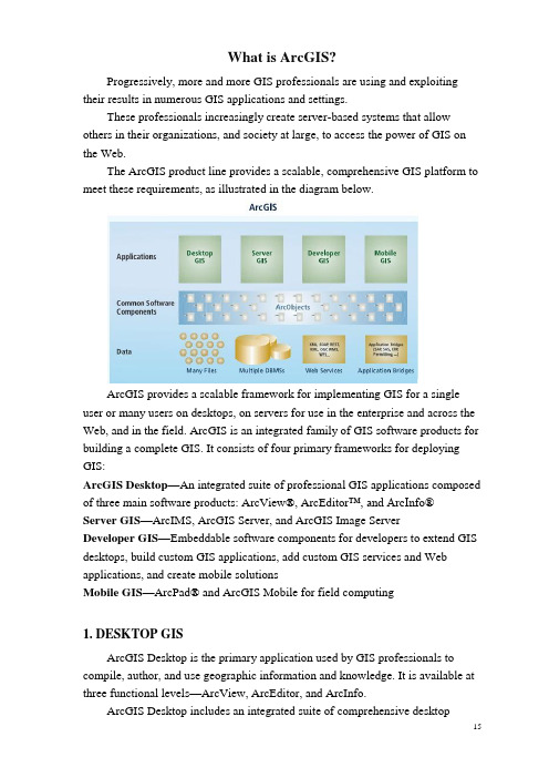
What is ArcGIS?Progressively, more and more GIS professionals are using and exploiting their results in numerous GIS applications and settings.These professionals increasingly create server-based systems that allow others in their organizations, and society at large, to access the power of GIS on the Web.The ArcGIS product line provides a scalable, comprehensive GIS platform to meet these requirements, as illustrated in the diagram below.ArcGIS provides a scalable framework for implementing GIS for a single user or many users on desktops, on servers for use in the enterprise and across the Web, and in the field. ArcGIS is an integrated family of GIS software products for building a complete GIS. It consists of four primary frameworks for deploying GIS:ArcGIS Desktop—An integrated suite of professional GIS applications composed of three main software products: ArcView®, ArcEditor™, and ArcInfo®Server GIS—ArcIMS, ArcGIS Server, and ArcGIS Image ServerDeveloper GIS—Embeddable software components for developers to extend GIS desktops, build custom GIS applications, add custom GIS services and Web applications, and create mobile solutionsMobile GIS—ArcPad® and ArcGIS Mobile for field computing1. DESKTOP GISArcGIS Desktop is the primary application used by GIS professionals to compile, author, and use geographic information and knowledge. It is available at three functional levels—ArcView, ArcEditor, and ArcInfo.ArcGIS Desktop includes an integrated suite of comprehensive desktopapplications—ArcMap, ArcCatalog™, ArcToolbox™, and ArcGlobe. Each application has a rich set of GIS tools and operators.ArcGIS Desktop can also be extended by purchasing a range of optional extensions that add specialized capabilities. For example:• The ArcGIS Spatial Analyst extensio n adds raster geoprocessing and modeling. • The ArcGIS 3D Analyst extension adds many 3D GIS capabilities and visualization applications.• The ArcGIS Data Interoperability extension adds the ability to directly use dozens of GIS data formats in ArcGIS.ArcGlobe ArcMap2. SERVER GISMuch like the enterprise software evolutions witnessed in the financial, human resources, supply chain, and customer management arenas, GIS has evolved to meet enterprisewide needs, supporting mission-critical capabilities and robust architectures associated with other enterprise software and infrastructure.Server GIS provides the basis for building an integrated, multidepartmental system for collecting, organizing, analyzing, visualizing, managing, and disseminating geographic information. Server GIS solutions are intended to address both the collective and individual needs of an organization and to make geographic information and services available to both GIS and non-GIS professionals.The principal purposes of a Server GIS are to provide:• Broad access to geographic information• A common infrastructure on which to build and deploy GIS applications• A common GIS data management framework• Significant economies of scale and business v alue through organization-widedeployment and use of GISArcGIS includes three server productsArcIMS —A scalable Web mapping server for GISpublishing of maps, data, and metadata using openInternet protocols.ArcIMS is deployed in tens of thousands oforganizations and is used primarily for GIS Webpublishing, delivering data and map services tomany users on the Web, and hosting metadatacatalog portals on the Web.ArcGIS Server —A comprehensive Web-basedGIS that provides a range of out-of-the-box end-user applications and services for mapping, analysis, data collection, editing, and management of spatial information. ArcGIS Server provides a cost-effective, standards-based platform upon which ArcGIS Desktop users can easily publish and serve their geographic knowledge to the broader organization.ArcGIS Server supports access using a range of desktop, custom, mobile, and browser-based clients.ArcGIS Server also includes the ArcSDE® data management technology for managing multiuser, transactional geodatabases using a number of relational database management systems (RDBMSs).ArcGIS Image Server —An on-the-fly image processing server, ArcGIS Image Server provides very fast access to large image collections and significantly reduces the time between image acquisition and use. ArcGIS Image Server can create multiple products dynamically as a Web service and supports image access by a range of client applications. Image Server is available as an optional extension product for ArcGIS Server.3. DEVELOPER GISThe ESRI Developer Network (EDNSM) is a developer product that provides a comprehensive system for developing applications with ArcGIS. EDN provides a unified programming environment and tools that enable developers to: • Embed GIS and mapping functionalit y in other applications.• Build and deploy custom ArcGIS Desktop applications and extensions.• Configure and customize ArcGIS products, such as ArcView, ArcEditor, and ArcInfo.Three server products —ArcIMS, ArcGIS Server, ArcGIS Image Server• Extend the ArcGIS architecture and data model.• Write custom applications using ArcGIS Engine.• Build Web services and server-based applications using ArcGIS Server and ArcIMS.EDN includes all the developer resources of ArcGIS Desktop, ArcGIS Server, ArcIMS, ArcSDE, and the embeddable components of ArcGIS Engine.The core of the EDN Developer Kit is a common library of software components, ArcObjects™, that programmers can use to embed and extend GIS using standard programming environments such as C++, .NET, and Java®.ArcGIS EngineArcGIS Engine is a developer product that provides a programming interface to use ArcObjects as a series of embeddable components with which developers can build focused applications with simple, custom interfaces.ArcGIS Engine provides a series of embeddable user interface components—for example, a Map control and a Globe control that can be used to embed interactive maps or globes in any application. Using ArcGIS Engine, developers can build focused GIS solutions using C++, .NET, or Java.Developers can build complete custom applications with ArcGIS Engine or embed GIS logic into existing user applications—for example, to add a map to Microsoft Word or Excel®.The use of custom applications is important for many GIS organizations to simplify and focus the use of GIS for numerous end users. For example, embedded GIS applications are used to support field data collection using Tablet PCs, custom interfaces for emergency operations, and structured data compilation workflows.Use ArcGIS Engine to embed GIS into your applications.4. MOBILE GISIncreasingly, GIS is moving from the office into the field by means ofGIS can be taken into the field using mobile devices and solutions. focused application solutions on mobile devices. Wireless mobile devices enabled with Global Positioning Systems (GPS) are increasingly used for focused data collection, map use, and GIS access in the field. Firefighters, waste collectors, engineering crews, surveyors, utility workers, soldiers, census workers, police, and field biologists represent a few types of field-workers who use mobile GIS as a tool.ArcGIS provides a comprehensive suite of mobile GIS products that are designed for different applications and platform requirements. These include:ArcGIS Desktop and custom applications built using ArcGIS Engine. These are frequently deployed to the field on mobile laptops and Tablet PCs for users who need to work with geodatabases and detailed GIS maps.ArcPad. ArcPad provides a rich environmentfor the GIS-centric field-worker on Windows®CE-compatible devices. ArcPad is widely used inmore than 60,000 deployments.ArcGIS Mobile. ArcGIS Server includesArcGIS Mobile, which is used to create and deployfocused mobile applications for smartphones,Pocket PCs, and Tablet PCs.These applications support wirelesssynchronization with ArcGIS Server, GIS data replication, and editing.4. THE GEODATABASEThe geodatabase is a collection of geographic datasets of various types used in ArcGIS and managed in either a file folder or a relational database. It is the native data source for ArcGIS and is used for editing and data automation in ArcGIS.The geodatabase was designed as an open, simple geometry storage model and supports many possible storage mechanisms, such as:• Multiuser DBMSs—Oracle, Microsoft SQL Server, IBM DB2, and Informix® • Personal geodatabases using Microsoft Access™• File geo databases that operate across a range of operating systems• Geodatabase Extensible Markup Language (XML) for open exchange and interoperabilityGeodatabases support much more than feature classes, images, and attributes. They are instrumental in implementing critical advanced GIS integrity rules and behavior using comprehensive data types such as topologies, networks, rastercatalogs, terrains, cadastral fabrics, relationships, and domains.5. ONLINE CAPABILITIES OF ARCGISIn addition to software, ArcGIS includes a range of online capabilities and services that enrich its use. These online services provide access to: • Online maps and data• Up -to-date help for GIS users, developers, and administrators• ArcGIS user and developer communities• Online support resourcesGeodatabases can be stored and managedin relational DBMSs, file systems, andMicrosoft Access folders.Geodatabase application logic is alsoused to access and work with datasets in hundreds of formats and data structures.。
(完整版)ArcGIS主要功能简介

(完整版)ArcGIS主要功能简介ArcGIS 主要功能简介通过在课堂上以及在课外的研究课题中对GIS的学习探究和应用,我对GIS 的主体功能有了较为明晰的认识,我认为ArcGIS的主要功能包括以下几个方面:一、信息的输入和转换信息的输入和转换是将从外部各种渠道收集所得的原始数据输入到 GIS系统内部并转换为系统便于处理的内部格式的过程。
1、信息的输入包括对空间数据和属性数据这两类数据的输入,其中输入点、线、面这类带有空间位置和几何特性的要素为空间数据输入,而文字、表格和其他非几何数据的输入为属性数据输入。
2、信息的转换包括将我们常用的其他软件文件转换到GIS中,通过多个软件之间的联动获取比单纯用GIS输入来得更丰富的外界信息,例如将DWG格式文件转换输入到GIS中;除此之外还有通过ArcT oolbox这一强大的工具集进行的GIS内部的矢量数据和栅格数据之间的转换。
二、数据的编辑数据的编辑是对已有的数据进行修改更新以及建立它们之间的联系的过程。
主要包括拓扑关系的建立、数据的投影变换、扭曲拉伸、裁剪、拼接和提取、以及坐标校正等。
其中我们可以借助拓扑关系来编辑要素和检验数据质量。
三、数据的储存与管理GIS的这项功能提供空间与属性数据的储存和灵活调用的能力。
如今随着数据容量和复杂度不断增大、对数据储存速度的要求越来越高,GIS的储存功能也在不断发展,于是出现了网络GIS数据储存、基于微电子机械系统的储存器等新功能、新产品。
四、数据的查询数据的查询包括两个方面功能:通过空间位置查属性和通过属性查空间位置,即“某个特定位置有什么”和“某个特定要素在哪里”。
五、数据的分析空间数据的分析是GIS的核心功能,它能够通过对基础数据的分析并叠加其影响来量化解决现实生活中与空间相关的实际问题,应用范围很广阔,其中包括栅格、矢量数据分析,三维分析和网络分析。
1、栅格数据分析:包括生成高程栅格、坡度栅格(可以通过高程栅格转换)、距离栅格、密度栅格,重分类、栅格计算等具体功能。
《ArcGis介绍》
整理课件
13
整理课件
14
3.专题地图的绘制
3.1 人口分级显示
整理课件
15
3.2 属性表里面的字段
整理课件
16
3.3 图层属性介绍
整理课件
17
4. 编辑要素
4.1数据库建立:文件地理数据库、个人数据库。
整理课件
18
文件地理数据库:是以文件夹形式存储的各种类型的
GIS数据集的集合,可以存储、查询和管理空间数据和非空间 数据。在不使用DBMS的情况下能够扩展并存储大量数据。文 件地理数据库可同时有多个用户使用,但一个数据只能有一个 用户编辑。因此,一个文件地理数据库可以由多个编辑者访问, 但必须编辑不同的数据。
1.3坐标系定义
坐标系定义原则:必须定义为待定义文件本身真实正确的坐标系。如不
知道其真实坐标系,一般不能直整理接课定件 义。
21
定义操作不会改变坐标值,因此如定义错误,可重新定义覆盖。
整理课件
22
4.2.2 面状要素编辑
整理课件
23
非常感谢大家耐心的观看。
整理课件
24
感谢亲观看此幻灯片,此课件部分内容来源于网络, 如有侵权请及时联系我们删除,谢谢配合!
2.2.2 窗口内容表:用于显示地图所包含的数据组(Data
Frames)、数据层(Layers),地理要素(Features)及显示状态。 可以控制数据组、数据层的显示与否,可以设置地理要素的表示方 法。
内容表有三种状态: a 地图要素显示状态(Display),显示所有数据层地理要素的类型和表 示方法。 b 地图数据源显示状态(Source),除了显示地理要素外,还说明数据 的存放路径和组织方式。 c 数据选择状态(Selection),用于控制数据层的选择与否。
- 1、下载文档前请自行甄别文档内容的完整性,平台不提供额外的编辑、内容补充、找答案等附加服务。
- 2、"仅部分预览"的文档,不可在线预览部分如存在完整性等问题,可反馈申请退款(可完整预览的文档不适用该条件!)。
- 3、如文档侵犯您的权益,请联系客服反馈,我们会尽快为您处理(人工客服工作时间:9:00-18:30)。
WHY USE ARCGIS ENGINE?Many users require focused, lightweight access to GIS, embedded in an application or as a standalone application. For example, users may need much less than ArcView yet still require access to sophisticated GIS logic in their application. In cases where users need focused, customized access to GIS, ArcGIS Engine provides a lower-cost, lightweight option. ArcGIS Engine is used to: • Embed GIS logic in custom applications. • Efficiently build and deploy GIS applications. • Provide access to advanced GIS logic from simple applications. • Embed GIS logic and maps in other applications. • Build cross platform applications with C++ or Java.96 • What is ArcGIS?7Mobile GIS: ArcP cPad ArcPad and devices devices97MOBILE COMPUTINGMobile computing is creating fundamental changes by adding the ability to take GIS with you into the field and interact directly with the world around you. Mobile GIS comprises the integration of a number of technologies: • GIS • Mobile hardware in the form of lightweight devices and ruggedized field PCs • GPS • Wireless communications for Internet GIS access Traditionally, the process of field data collection and editing has been time-consuming and error-prone. Geographic data has traveled into the field in the form of paper maps. Field edits were performed using sketches and notes on paper maps and clipboards. Once back in the office, these field edits were deciphered and manually entered into the GIS database. The result has been that GIS data has often not been as up-to-date or as accurate as it should have been. Consequently, GIS analysis and decisions have been delayed. Recent developments in mobile technologies have enabled GIS information to be taken into the field as digital maps on compact, powerful mobile computers, providing field access to enterprise geographic information. This enables organizations to add real-time (and near real-time) information to their enterprise database and applications, speeding up analysis, display, and decision making by using up-to-date, more accurate spatial data. Many field-based tasks utilize geographic information that has benefited from the increased efficiency and accuracy of mobile GIS, including: • Asset inventory, which usually requires field data collection or mapping • Asset maintenance, which usually requires updates to attribute information and geometry of GIS features • Inspections, typically involving field assets or legal code compliance • Incident reporting—for example, spatially recording accidents or events • GIS analysis and decision makingThese field-based tasks are common to many GIS applications, such as utility inspections and maintenance, mapping of natural resources, mineral exploration, recording of accidents, inspection of compliance to local government codes, mapping of wildfires, and many more. Some of the field-based tasks involve fairly simple operations that require simple geographic tools. In contrast, some field-based tasks involve complex operations and, consequently, require sophisticated geographic tools. ArcGIS includes applications that meet the requirements of both of these needs: • ArcPad focuses on field tasks that require relatively simple geographic tools. These tasks are typically performed on handheld computers (running Microsoft Windows CE or Pocket PC). • ArcGIS Desktop and ArcGIS Engine focus on field tasks that require more sophisticated geographic tools. These tasks are typically performed on high-end Tablet PCs. Field GIS also relies heavily on application customization to simplify mobile work tasks as well as wireless access to real-time data feeds from central GIS Web servers, such as sites deployed with ArcIMS and ArcGIS Server.98 • What is ArcGIS?ARCPAD: MAPPING AND GIS FOR MOBILE SYSTEMSESRI’s ArcPad software is mobile mapping and GIS technology for mobile Windows devices. ArcPad provides database access, mapping, GIS, and GPS integration to field users via handheld and mobile devices. Data collection with ArcPad is fast and easy and improves fieldbased data validation and availability.COMMON ARCPAD FUNCTIONSEXAMPLES OF ARCPAD APPLICATIONSArcPad is typically used for building specialized mapping and data collection applications. The following list includes examples of ArcPad applications: • Street sign inventory • Power pole maintenance • Meter reading • Road pavement management • Military fieldwork • Mineral exploration • Habitat studies • Toxic inventory • Crop management • Property damage assessment • Field surveying • Incident reporting and inspection • Real-time wildfire boundary mapping • Refuse container inventory • Wildlife tracking • GIS data validationARCPAD APPLICATION BUILDER• Support for industry-standard vector and raster image display • ArcIMS client for data access via wireless technology • Map navigation, including pan and zoom, spatial bookmarks, and center on the current GPS position • Data query to identify features, display hyperlinks, and locate features • Map measurement: distance, area, and bearings • GPS navigation to connect a GPS and let ArcPad guide you • Simple editing: creating and editing spatial data using input from the mouse pointer, pen, or GPS • Mobile geodatabase editing: checking out, converting, and projecting your GIS data using ArcGIS; editing in the field with ArcPad, and posting changes back to the central GIS database • Application development to automate GIS fieldworkCreating a personalized and custom field solution for mapping, data collection, and updates is essential for mobile GIS. ArcPad users are able to customize ArcPad and build focused applications using ArcPad Application Builder. ArcPad Application Builder runs on Windows computers. Developers build custom applications within this environment and can deploy them on numerous ArcPad devices in their organization.ArcPad supports numerous Windows CE and Pocket PC devices.Mobile GIS: ArcPad and devices • 99ARCGIS DESKTOP AND ARCGIS ENGINE ONTABLETPCMany users have requirements for high-end field computers with built-in GPS. These field computers run the full Windows operating system and are used for remotely performing many advanced computer-based tasks. In recent years, Microsoft has introduced a new operating system called the Microsoft Windows XP Tablet PC Edition, which enables many innovative features such as pen-based computing, digital ink technology, and enhanced mobility functions. ArcGIS Desktop running on Tablet PCs is a powerful mobile platform for advanced GIS field computing. Tablet PC technology enables users to redline designs, capture accurate field measurements using GPS, and leverage the comprehensive functionality of ArcGIS and the geodatabase in the field.OVERVIEW OF TABLET PCARCGIS DESKTOP AND ARCGIS ENGINE ON THE TABLET PCArcGIS includes a series of tools for Tablet PCs that enable users to take advantage of the Tablet PC’s innovative features—pen-based computing, digital ink technology, and enhanced mobility functions as well as the rich mapping and data compilation capabilities of ArcGIS. The primary focus at ArcGIS 9 has been on supporting ArcGIS Desktop and its rich mapping and editing tools on Tablet PCs. Tablet PC capabilities also work well with ArcGIS Engine. For example, ArcGIS Engine users can use the pen interface to highlight and query features, add and change attribute values, and interact with their custom applications. The ArcGIS Desktop application ArcMap has been extended with a Tablet PC toolbar that integrates digital ink technology with ArcGIS. Using the Tablet toolbar, users can access the ink tool to create notes or sketch diagrams and tie them to a geographic location. The ink tool can also be used to highlight features on a map and sketch shapes that can be used to perform GIS editing tasks. Tablet tools make use of ink technology such as gestures and text recognition.A key capability of Tablet PC is the use of a pen-based interface for computer interaction, sketching, and capturing notes. These activities are based on a technology called digital ink. Digital ink is created through sketching and can be converted to text using the text recognition engine, added to the edit sketch for any editing task, or stored as a graphic in datasets. The Tablet PC platform is commonly used in four ways: • Tablet PC as a notebook computer: The Windows XP Tablet PC Edition is a superset of the existing Windows XP operating system. • Tablet PC pen-based technology: The Tablet PC lets you drive the Windows XP operating system and all Windows-based applications using a digital pen instead of a mouse. For example, in ArcGIS, the digital pen can be used to push buttons on toolbars and draw on the map. • Windows XP speech recognition: The speech recognition functionality is embedded within the Tablet PC input panel and can be used with ArcGIS for dictation functions. • Tablet PC digital ink technology: Pen interfaces are used for sketching with Tablet PCs. Digital ink, created through sketching, can be converted to text using the text recognition engine, added to the edit sketch for completion of a current editing task, or stored as a graphic.The ArcGIS mapping application ArcMap includes a toolbar that integrates digital ink technology with ArcGIS. Using the Tablet toolbar, you can access the Pen tool to create notes or sketch diagrams and tie them to a geographic location.The Tablet tools for ArcGIS Desktop add a graphic element called an ink graphic. Ink graphics are stored along with other graphic elements and text in the map’s graphics layer or as annotation in the geodatabase. Therefore, you100 • What is ArcGIS?can create ink using ArcGIS and choose whether to store it in the map or the geodatabase you are editing.TABLET PC CUSTOMIZATIONMobile GIS requires focused application designs and customization to build productive, simple user interfaces for field-workers. Since ArcGIS is being used, the same customization and ArcObjects programming work done for all of ArcGIS can be leveraged for building and deploying Tablet PC applications.Sketches and notes created in ArcMap on the Tablet PC are geographically referenced and can be saved as map graphics or as annotation in the geodatabase.Here is a list of some of the Tablet toolbar functions: • Pen tool creates new ink graphics on the map. • Highlighter tool draws transparent ink on the map for highlighting features. • Erase tool removes strokes of ink from the map display. • Finish Ink Sketch command creates new ink graphic elements from the ink that is being collected on the map. • Clear Ink Sketch command removes all ink that is being collected. • Add Ink To Sketch command lets ink be used to complete the current editing task (such as creating new features). • Recognize Ink Graphic command converts selected ink graphics written with the Pen tool into text elements. • Reactivate the Selected Ink Graphic command creates a new ink sketch from the selected ink graphic so it can be edited using the Pen or Highlighter tool. • Find Ink Graphic tool searches the map or a geodatabase for ink based on its recognized text.Mobile GIS: ArcPad and devices • 1018Future Future GIS trends trends103FUTURE GIS TRENDSGIS will continue to grow and evolve. Its evolution will be based on a series of fundamental GIS characteristics as well as computing and Internet trends. Here are some of the important factors that exert an influence: • GIS has been evolving from a database and data sharing approach to a knowledge approach. A GIS is much more than a database. In addition to GIS datasets, GIS users work with maps and globes, geoprocessing and work flow models, and multipurpose GIS database designs (data models). All of these are documented using metadata to enable publishing and sharing of geographic knowledge. • GIS systems are becoming federated, and geographic knowledge is being shared on the Web. Users will also share and replicate updates between their systems, and Internet GIS will increase in sophistication and use. Increasingly distributed GIS capabilities will be thought of as an integral part of a GIS platform. • In the past few years, GIS catalog portals have been providing centralized access to distributed information sets at many organizations. Over time, GIS portals will also help integrate distributed GIS data management and use.• Individual GIS systems continue to be increasingly connected in a loosely-coupled manner on the Web. The Internet is fast becoming the framework for integrated access to geographic knowledge that will continue to be built, maintained, and published at many independent GIS nodes. This vision has been described over the past decade as a National or Global SDI. Integrative technologies to implement this vision are growing. • GIS systems are inherently distributed. Users rely on one another for information sharing and use. Distributed GIS is much more than distributing GIS databases and dataset copies. It will also be about distributed collaboration on all GIS tasks. In addition to GIS publishing and data sharing, users will leverage the Internet to compile, apply, and manage geographic knowledge. This final chapter presents some of these key trends and provides a context for how GIS will grow and evolve in the coming years. The ArcGIS platform has been built to address and evolve support for these key trends.104 • What is ArcGIS?INTELLIGENT GIS“GIS is evolving from a database approach to a knowledge approach.” —ESRI President Jack Dangermond, July 2003 Historically, humans have learned to express knowledge and share it through many abstract forms. These abstractions, summaries of the larger body of knowledge, have been continually used to explain the human experience and collective understanding. Abstractions— such as text, hieroglyphics, language, mathematics, music and art, drawings, images, and maps—are used to record and communicate culture and civilization from generation to generation.Statistical Analysis & Tabular Data Digital g it l Movies/Sound M d Text Tex Tex e ext Processing P s Computer p ter er Models s Image I Processing Proc r roc Mobile le e Document ocument c Management Management Virtual t tual Reality eality a yStatistics Language Math/ScienceX=Y-Z NaCl 2Digital technology is increasingly used to capture everything we know.HieroglyphicsModelsGeography has traditionally provided an important framework and a language for organizing and communicating key concepts about the world. GIS provides a comparatively new mechanism for capturing geographic knowledge into five basic elements: • Maps and globes Interactive views of geographic information with which to answer many questions, present results, and use as a dashboard for real work • Geographic datasets File bases and databases of geographic information— features, networks, topologies, terrains, surveys, and attributes • Processing and work flow models Collections of geoprocessing procedures for automating and repeating numerous tasks • Data models The schema, behavior, and integrity rules of geographic datasets • MetadataCrosier, S. J., Goodchild, M., et al. (2003) “Developing an Infrastructure for Sharing Environmental Models” Environment and Planning B: Planning and Design 2003, volume 30(4) July, pages 487 – 501 Crosier, S. J. (2001) "Defining Space - A Metadata Approach" Of Significance 2001, Volume 3(2) pages 26 – 31 Hill, L. L., S. J. Crosier, et al. (2001). A Content Standard for Computational Models. D-Lib Magazine. 7. (Available: /dlib/june01/ hill/06hill.html)Music/Art DrawingsMapsImagesHumans use many abstractions to express and communicate the collective understanding of the earth and its systems. Geography provides a universal framework for abstraction and communication about “place”.In the digital computing age, everything known has begun to be captured and shared across networks (the World Wide Web). These knowledge collections are rapidly becoming digitally enabled. Simultaneously, GIS is evolving to help humans better understand, represent, manage, and communicate many aspects of the earth as a system.Documents describing the other elements—a document catalog enabling users to organize, discover, and gain access to shared geographic knowledgeFuture GIS trends • 105106 • What is ArcGIS?These five elements, along with comprehensive GISsoftware logic, form the building blocks for assemblingintelligent geographic information systems. Intelligent GISmakes it possible to digitally encapsulate geographicknowledge. These elements provide a foundation foraddressing many challenges using GIS (for example,improvements in efficiency, intelligent and informeddecision making, science-based planning, resourceaccounting, evaluation, and communication).Intelligent GIS will enable the capture and sharing ofgeographic knowledge in many forms—as advanced GISdatasets, maps, data models, the expertise of professionalswho have developed standardized work flows, andadvanced models of geographic processes. Intelligent GISwill also enable the building and management ofknowledge repositories that can be published for others touse.ArcGIS and the geodatabase were engineered to supportthis knowledge-based approach. They enable the creation,use, management, and sharing of all five geographic knowledge elements.GIS SoftwareCrosier, S. J., Goodchild, M., et al. (2003)“Developing an Infrastructure for SharingEnvironmental Models” Environment and PlanningB: Planning and Design 2003, volume 30(4) July,pages 487 – 501Crosier, S. J. (2001) "Defining Space - A MetadataApproach" Of Significance 2001, Volume 3(2)pages 26 – 31Hill, L. L., S. J. Crosier, et al. (2001). A ContentStandard for Computational Models. D-Lib Magazine.7. (Available: /dlib/june01/hill/06hill.html)Data ModelsGlobes Geodata SetsMetadataGIS abstracts geography into five basic elements used for representing geographicknowledge. These elements, along with advanced software, provide the buildingblocks for intelligent GIS.Future GIS trends • 107GIS users have long relied on collaborative efforts for datasharing and use. Today, there is widespread recognitionthat the datasets and tables in most geographicinformation systems come from multiple organizations.Each GIS organization develops some, but not all, of itsinformation content. At least some of the layers comefrom outside the organization.The most important standards for GIS will be based onmany of the emerging computing and Web standards. TheInternet already plays a critical role in distributed GIS andwill continue to do so. Emerging technology frameworkswill help immensely. Modern Web services frameworksbased on XML and SOAP will enable independent systemsto interoperate across the Web. Emerging frameworks forwireless communications and browser-based access tocentral enterprise applications will mean that GIS can bedistributed in any computer environment to many users.Evolving GIS standardsIn particular, Web services will provide a loosely coupled enterprise computing environment that enables users to connect to information and GIS functionality over the World Wide Web from their desktops, Web browsers, and mobile devices. GIS logic will be deployed in all appropriate technical frameworks.Most important, Web services can also be used to integrate many individual systems, regardless of their internal architectures.Web services provide a new type of interoperability for integrating many systems.108 •What is ArcGIS?Most GIS data sharing activities continue to be based onsimple mechanisms of file sharing and FTP downloads ofdata copies. However, data sharing frameworks areincreasing in sophistication. For example, GIS Webpublishing is widely applied using ArcIMS and similartechnologies. Also, the deployment of GIS catalog portalsis increasing, providing centralized access to openlypublished geographic information at many GIS sites. Allthese distributed GIS applications will continue to beimportant.GIS system architectures are evolving and becoming distributed on the Internet.Central CatalogGIS CatalogPortalUsers search &discoverIn addition to GIS data publishing and use, GIS users will increase collaboration for distributed GIS data management and geoprocessing. Some organizations will build increasingly sophisticated enterprise systems to support all these activities, and others will implement a subset of these activities based on their specific requirements.The summary table below presents some usage patterns emerging in Internet GIS use.In practice, GIS users will fall anywhere along this spectrum of Internet GIS use. The data sharing requirements in their organizations will dictate the required level of Internet GIS implementation. Many organizations will continue to grow and evolve increasingly sophisticated GIS practices moving down this spectrum of activities.GIS software technology must continue to evolve to add this advanced support yet must also remain flexible enough to support the complete spectrum of GIS implementations.Simpl eAdvancedA growing spectrum of GIS use on the InternetFuture GIS trends • 109110 •What is ArcGIS?Many organizations depend on collaborative GIS—the construction and maintenance of up-to-date, multiscale,continuous geographic information, not as the activity of a single organization but through a collaboration of many GIS partners.Currently, most GIS organizations build and maintain their own geographic content. Although the information varies widely between organizations, many started with the same core datasets, updating, and enriching them to meet their specific needs.Most users see the potential for sharing and reusing these enriched datasets. Many are interested in combining their enriched GIS datasets into comprehensive coverages for larger areas that are multipurpose and can serve the needs of numerous organizations and applications. In addition,they want to collaborate on building additional key GIS data layers. A series of important GIS applications, such as cadastral data management, national mapping, emergency response, and homeland security are driving these requirements.One vision for accomplishing this involves creating a distributed network of GIS organizations, each of which has data ownership and data sharing responsibilities for portions of a shared database.The GIS databases are envisioned to be multipurpose and adhere to guidelines for common representation and content. Each participant would use the local GIS to build, maintain, share, and publish GIS data for aparticular piece of geography and for selected themes of geographic information.Collaborative GIS would go a step further to connect and integrate the individual data providers into a GIS network that could be used to integrate the individual parts into a whole (for example, to maintain a comprehensive coverage of geographic information for large local governments, states, nations, and the world). Users also envision a framework in which updates can be replicated and shared across the Internet to maintain synchronized copies of intelligent GIS databases.Six fundamental GIS technologies will be required to achieve this vision:1.Open, multipurpose GIS data management technology.Geographic information must be built and maintained for reuse. Geographic information must be shared using widely adopted GIS data mon data models (content standards) for essential information. Data interoperability is essential. Users can build upon essential, reusable GIS database schemas and add their specialized data requirements to the essential data prehensive GIS tools for building and authoring geographic information—for example, data creation and editing, data conversion, geoprocessing, metadata documentation and cataloging, cartography, and mapping. The GIS desktop will continue to be the primary platform for this work.Future GIS trends • 1114.Web-based data management and disseminationframework. GIS server technology, GIS networks, and GIS portals on the World Wide Web will provide a standards-based framework for multiparticipant GIS.GIS portals will play a key role. These will be built on widely adopted Web computing standards such as Web services.5.The practical application of widely adopted best GIS practices, methods, and procedures. To encourage broad participation, collaborative GIS must fit how GIS users accomplish their work. Users should push practical technical limits, not theoretical frontiers, in collaboration and participation. GIS standards must be practical and should be derived from best practices and widely adopted methods.6.The application of and adherence to proven industry standards. Adoption of the commonly used information technology and computing is required for distributed, collaborative GIS.These and other GIS visions can be engineered using comprehensive GIS technology, such as the intelligent GIS databases, comprehensive desktop GIS, embedded GIS,server GIS, and mobile GIS, to support these concepts and requirements.ArcGIS 9Desktop GISEmbedded GIS Server GIS ArcGIS DesktopMobile GIS ArcGIS Server ArcIMS ArcGIS Mobile ArcPadDesktopDevelopment KitEngine Development Kit Server Development Kit .NET C++ VB .NET C++ VB J AVA JAVA ADF NET ADF C++ArcView ArcEditorArcReader ArcInfo + ArcGIS ExtensionsPEI Compact FrameworkComponent Building BlocksDesktop Server WebCustom Applications ArcGIS Engine Web TemplatesCustom TemplatesArcObjectsMobile Development Kit3D multipatchSee multipatch.address geocodingSee geocoding.analysisThe process of identifying a question or issue to be addressed, modeling the issue, investigating model results, interpreting the results, and possibly making a recommendation.annotationDescriptive text used to label features on or around a map. Information stored for annotation includes a text string, a position at which it can be displayed, and display characteristics.ArcIMSESRI software that allows scalable Internet mapping and distributed GIS solutions. The administrative framework lets users author configuration files, publish services, design Web pages, and administer ArcIMS Spatial Servers. ArcIMS supports Windows, Linux, and UNIX platforms and is customizable on many levels.ArcSDEServer software that provides ArcSDE client applications (for example, ArcGIS Desktop, ArcGIS Server, ArcIMS) with a gateway for storing, managing, and using spatial data in one of the following commercial database management systems: IBM DB2 UDB, IBM Informix, Microsoft SQL Server, and Oracle.attributermation about a geographic feature in a GIS,generally stored in a table and linked to the feature by a unique identifier. For example, attributes of a rivermight include its name, length, and average depth.2.In raster datasets, information associated with eachunique value of raster cells.3.Cartographic information that specifies how featuresare displayed and labeled on a map; the cartographicattributes of a river might include line thickness, line length, color, and font.See also polygon.attribute keySee primary key.CAD datasetSee CAD feature dataset.CAD feature datasetThe feature representation of a CAD file in a geodatabase-enforced schema. A CAD feature dataset is composed of five read-only feature classes: points, polylines, polygons, multipatch, and annotation. Formats supported by ArcGIS include AutoCAD (DWG), AutoDesk Drawing Exchange Format (DXF), and the default MicroStation file format (DGN).cartographyThe art and science of expressing graphically, usually through maps, the natural and social features of the earth. check-inThe procedure that transfers a copy of data into a master geodatabase, overwriting the original copy of that data and reenabling it so it can be accessed and saved from that location.check-outA procedure that records the duplication of data from one geodatabase to another and disables the original data so that both versions cannot be accessed or saved at the same time.check-out geodatabaseA personal or ArcSDE geodatabase that contains data checked out from a master geodatabase.Glossary。