SAR processing in both low earth orbit (LEO) and geosynchronous SAR (GeoSAR) configurations
军事英文术语
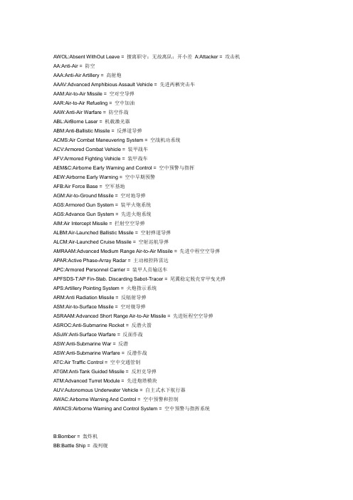
AWOL:Absent WithOut Leave = 擅离职守;无故离队;开小差A:Attacker = 攻击机AA:Anti-Air = 防空AAA:Anti-Air Artillery = 高射炮AAAV:Advanced Amphibious Assault Vehicle = 先进两栖突击车AAM:Air-to-Air Missile = 空对空导弹AAR:Air-to-Air Refueling = 空中加油AAW:Anti-Air Warfare = 防空作战ABL:AirBorne Laser = 机载激光器ABM:Anti-Ballistic Missile = 反弹道导弹ACMS:Air Combat Maneuvering System = 空战机动系统ACV:Armored Combat Vehicle = 装甲战车AFV:Armored Fighting Vehicle = 装甲战车AEM&C:Airborne Early Warning and Control = 空中预警与指挥AEW:Airborne Early Warning = 空中早期预警AFB:Air Force Base = 空军基地AGM:Air-to-Ground Missile = 空对地导弹AGS:Armored Gun System = 装甲火炮系统AGS:Advance Gun System = 先进火炮系统AIM:Air Intercept Missile = 拦射空空导弹ALBM:Air-Launched Ballistic Missile = 空射弹道导弹ALCM:Air-Launched Cruise Missile = 空射巡航导弹AMRAAM:Advanced Medium Range Air-to-Air Missile = 先进中程空空导弹APAR:Active Phase-Array Radar = 主动相控阵雷达APC:Armored Personnel Carrier = 装甲人员输送车APFSDS-T:AP Fin-Stab. Discarding Sabot-Tracer = 尾翼稳定脱壳穿甲曳光弹APS:Artillery Pointing System = 火炮指示系统ARM:Anti Radiation Missile = 反辐射导弹ASM:Air-to-Surface Missile = 空对舰导弹ASRAAM:Advanced Short Range Air-to-Air Missile = 先进短程空空导弹ASROC:Anti-Submarine Rocket = 反潜火箭ASuW:Anti-Surface Warfare = 反面作战ASW:Anti-Submarine War = 反潜ASW:Anti-Submarine Warfare = 反潜作战ATC:Air Traffic Control = 空中交通管制ATGM:Anti-Tank Guided Missile = 反坦克导弹ATM:Advanced Turret Module = 先进炮塔模块AUV:Autonomous Underwater Vehicle = 自主式水下航行器AWAC:Airborne Warning And Control = 空中预警和控制AWACS:Airborne Warning and Control System = 空中预警与指挥系统B:Bomber = 轰炸机BB:Battle Ship = 战列舰BC:Battle Cruiser = 战列巡洋舰BDA:Battle Damage Assessment = 战斗损害评估BPI:Boost Phase Intercept = 加速阶段拦截BRAA:Bearing, Range, Altitude and Aspect = 目标飞行情况BVR:Beyond Visual Range = 超视距BVRAAM:Beyond Visual Range Air-to-Air Missile = 超视距空空导弹C:Carrier = 运输机C3:Command, Control and Communication = 指挥控制通信系统CAP:Combat Air Patrol = 战斗空中巡逻CAS:Close Air Support = 近距空中支援CASE:Computer Aided Software Engineering = 电脑辅助软件工程CBU:Clustered Bomb Unit = 集束炸弹CENTCOM:Central Command = 中央司令部CFC:Carbon Fiber Composite = 碳纤维复合材料CC:Cruiser = 巡洋舰CG:Cruiser (Guided-missile) = 导弹巡洋舰CIC:Combat Information Center = 战斗信息中心CIC:Commander in Chief = 最高指挥官CIWS:Close-In Weapon System = 近战武器系统CIWS:Close Intercept Weapon System = 近程防御系统CNO:Chief of Naval Operation = 海军作战部长COMINT:Communication Intelligence = 通信情报COMDAC INS:Command Display and Control Integrated Navigation System = 集成控制导航系统CR:Close Range = 近程C/S:Course and Speed = 航向与速度CV:Carrier Vessel = 常规动力航空母舰CVN:Carrier Vessel (Nuclear-powered) = 核动力航母CVBG:Carrier Battle Group = 航母战斗群DASS:Defensive Aids Sub-System = 防御性辅助子系统DD:Destroyer = 驱逐舰DDG:Destroyer (Guided-missile) = 导弹驱逐舰DU:Depleted Uranium = 贫铀DVI:Direct Voice Input = 直接语音输入技术E:Electronic = 电子战机ECCM:Electronic Counter-Counter Measures = 电子反对抗,反电子战ECM:Electronic Counter Measures = 电子对抗,电子战ELINT:Electronic Intelligence = 电子情报EMCON:Emissions Control = 发射控制EML:ElectricMagnet Launcher = 电磁炮EMP:ElectricMagnet Palse = 电磁脉冲ERAAM:Extended Range Air-to-Air Missile = 延程空空导弹ESM:Electronic Signal Measures = 电子信号警告ESM:Electronic Support Measures = 电子支援ETG:Electro Thermal Gun = 电热炮ETCG:Electro Thermal Chemical Gun = 电热化学炮EW:Early Warning = 预警EW:Electronic Warfare = 电子战EWAC:Early Warning And Control= 预警及控制F:Fighter = 战斗机FAE:Fuel Air Explosive = 油气炸弹FEL:Free Elctron Laser = 自由电子激光器FF:Frigate = 护卫舰FFG:Frigate(Guided-missile) = 导弹护卫舰FLIR:Forward Looking Infra-Red = 前视红外FLOT:Forward Line Of Troops = 前线FMRAAM:Future Medium Range Air-to-Air Missile = 未来中程空空导弹FMTV:Family of Medium Tactical Vehicles = 中型战术车族GEM:Guidance-Enhanced Missile = 制导增强导弹GEO:Geo-Stationary Orbit = 地球同步轨道GPS:Global Positioning System = 全球定位系统GZ:Ground Zero = 核爆炸中心地面投影H:Helicopter = 直升机HE:High Explosive = 高爆炸药HEAT:High-Explosive Anti-Tank = 高爆反坦克炸药(成形炸药)HMD:Helmet Mounted Display = 头盔显示器HPM:High Power Microwave = 高功率微波HQ:Headquarters = 总部HUD:Head-Up Display = 抬头显示器HVU:High Value Unit = 高价值单位IADS:Integrated Air Defense System = 综合防空系统ICBM:Intercontinental Ballistic Missile = 洲际弹道导弹IFF:Identification of Friend or Foe = 敌我识别IFV:nfantry Fighting Vehicle = 步兵战车IPE:Individual Protection Ensemble = 单兵防护装备IRBM:Intermediate-Range Ballistic Missile = 中程弹道导弹IRST:Infra-Red Search and Track = 红外搜索跟踪JDAM:Joint Direct Attack Munitions = 联合直接攻击弹药JHMCS:Joint Helmet Mounted Cueing System = 联合头盔指引系统JSF:Joint Strike Fighter = 联合打击战斗机J-STAR:Joint Surveillance and Target Attack Radar system = 联合侦察和目标打击系统JTIDS:Joint Tactical Info Distribution System = 联合战术信息分发系统K:Kerosene = 加油机KIA:Kill in Action = 阵亡LANTIRN:Low-Alt. Nav.& Targeting Infra-Red for Night = 低空导航与目标指示红外夜视仪LAV:Light Armored Vehicle = 轻型装甲车辆LCA:Light Combat Aircraft = 轻型战斗机LEO:Low Earth Orbit = 近地轨道LD:Laser Designator = 激光导引LGB:Laser Guided Bomb = 激光制导炸弹LORCAP:Long-Range Combat Air Patrol = 长距离战斗空中巡逻LPT:Low Profile Turret = 低矮炮塔LRBM:Long-Range Ballistic Missile = 远程弹道导弹LRIP:Low Rate Initial Production = 低速试产MBT:Main Battle Tank = 主战坦克MC:Marine Corps = 海军陆战队MCA:Medium Combat Aircraft = 中型战斗机MCM:Mine Counter-Measures = 扫雷MFD:Multi-Function Display = 多功能显示器MFR:Multifunction Radar = 多用途雷达MIL-STD:Milliraty Standard = 军事标准MLU:Mid-Life Update = 中期延寿(战机)MOPP:Mission-Oriented Protective Posture = 攻击中的防范状态MOAB:Massive Ordnance Air Blast = 巨型空中炸弹MOAB:Mother Of All Bombs = 炸弹之母MPRF:Medium Pulse Repetition Frequency = 中脉冲重复频率MRLS:Multiple Rocket Launching System = 多管火箭发射系统NAVSSI:Navigation Sensor System Interface = 导航传感器系统界面NCTR:NonCooperative Target Recognition = 非己方目标识别NBC:Nuclear Biological and Chemical = 核、生物、化学OICW:Objective Individual Combat Weapon = 目标单兵战斗武器OOB:Order Of Battle = 战斗序列OPCW:Org. for the Prohibition of Chemical Weapons = 禁止化学武器组织OTH:Over the Horizon = 超视距OWS:Overhead Weapon System = 遥控炮塔P:Patrol = 巡逻机PA:Phase Array = 相控阵PAC:Patriot Advanced Capability = 改进型爱国者导弹PGM:Precision-Guided Munitions = 精确制导炸弹PIM:Path of Intended Motion = 预定机动路线PK:Probability of Kill = 杀伤率PLGR:Precision Lightweight GPS Receiver = 精确轻型GPS接收器R:Reconnaissance = 侦察机RATO:Rocket Assisted Take-Off = 火箭辅助起飞RCS:Radar Cross Section = 雷达截面RLG:Retractable Landing Gear = 回收式起落架ROE:Rules of Engagement = 交战规则ROV:Remote Operated Vehicle = 遥控车辆、飞机RPG:Rocket Propelled Grenade = 火箭助推榴弹RTB:Return To Base = 返回基地RTO:Ready to Take-Off = 起飞准备就绪RWR:Radar Warning Receiver = 雷达告警器SAM:Surface to Air Missile = 防空导弹SAR:Search and Rescue = 搜索救援SAR:Synthetic Aperture Radar = 合成孔径雷达SATCOM:Satellite Communication = 卫星通信SDV:Swimmer Delivery Vehicle = 潜水员输送载具SEAD:Suppression of Enemy Air Defense = 压制敌方防空任务SLBM:Submarine-Launched Ballistic Missile = 潜射弹道导弹SLGR:Small Lightweight GPS Receiver = 小型轻便GPS接收器SOP:Standard Operation Procedure = 标准操作程序SRBM:Short-Range Ballistic Missile = 近程弹道导弹SSBN:Ballistic-missile Nuclear-powered Strategic Sub. = 战略导弹核潜艇SSL:Solid State Lasers = 固态激光器SSM:Surface-to-Surface Missile = 面对面导弹SSN:Strike Submarine (Nuclear-powered) = 攻击型核潜艇SSNDS:SSN Direct Support = 直接支援核潜艇SSPK:Single-Shot Probability of Kill = 单发杀伤率START:Strategic Arms Reduction Treaty = 战略武器削减条约STK:Strike = 袭击STN:Satellite Tracking Network = 卫星跟踪网STOL:Short Take Off and Landing = 短距起降STOP:Simultaneous Time on Top = 同时到达SURTASS:SURface Towed Array Sonar System = 水面拖曳阵列声纳系统TASM:Tomahawk Anti-Ship Missile = 战斧反舰导弹TEL:Transporter/Erector/Launcher = 运输/起竖/发射车THAAD:Theater High Altitude Area Defense = 战区高空区域防空TLAM:Tomahawk Land Attack Missile = 战斧对地攻击导弹TMA:Target Motion Analysis = 目标运动分析TOW:Tube-launched Optic-tracked Wire-guided = 光学有线制导管内发射反坦克导弹(陶式导弹)TVC:Thrust Vector Converter = 矢量推力UAV:Unmanned Air Vehicle = 无人驾驶飞行器UCAV:Unmanned Combat Air Vehicle = 无人驾驶战斗机UFCP:Up Front Control Panel =(战机座舱)前部控制屏UUV:Unmanned Underwater Vehicle = 无人水下航行器VL:Verticle Landing = 垂直起降VLS:Vertical Launch System = 垂直发射系统VTOL:Vertical Take Off and Landing = 垂直起降WECDIS:Warship Electronic Chart Display and Information Systems = 海图显示和信息系统WRM:War Reserve Materials = 战争物资储备W/S:Weapon System = 武器系统WYPT:Waypoint = 路径点A,是空中(机载),I是对空,M是导弹,AIM就是空对空导弹了。
中国地质大学(北京)考博专业英复习材料
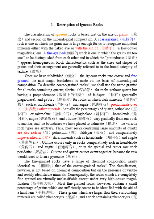
晶) is said to have a porphyritic texture(斑状结构). The classification of fine-grained rocks, then, is based on the proportion of minerals which form phenocrysts and these phenocrysts (斑晶)reflect the general composition of the remainder(残留) of the rock. The fine-grained portion of a porphyritic(斑岩) rock is generally referred to as the groundmass(基质) of the phenocrysts. The terms "porphyritic" and "phenocrysts" are not restricted to fine-grained rocks but may also apply to coarse-grained rocks which contain a few crystals distinctly larger than the remainder. The term obsidian(黑曜岩) refers to a glassy rock of rhyolitic(流纹岩) composition. In general, fine-grained rocks consisting of small crystals cannot readily be distinguished from③ glassy rocks in which no crystalline material is present at all. The obsidians, however, are generally easily recognized by their black and highly glossy appearanceass of the same composition as obsidian. Apparently the difference between the modes of formation of obsidian and pumice is that in pumice the entrapped water vapors have been able to escape by a frothing(起泡) process which leaves a network of interconnected pore(气孔) spaces, thus giving the rock a highly porous (多孔的)and open appearance(外观较为松散). ④ Pegmatite(结晶花岗岩) is a rock which is texturally(构造上地) the exact opposite of obsidian. ⑤ Pegmatites are generally formed as dikes associated with major bodies of granite (花岗岩) . They are characterized by extremely large individual crystals (单个晶体) ; in some pegmatites crystals up to several tens of feet in length(宽达几十英尺)have been identified, but the average size is measured in inches (英寸) . Most mineralogical museums contain a large number of spectacular(壮观的) crystals from pegmatites. Peridotite(橄榄岩) is a rock consisting primarily of olivine, though some varieties contain pyroxene(辉石) in addition. It occurs only as coarse-grained intrusives(侵入), and no extrusive(喷出的) rocks of equivalent chemical composition have ever been found. Tuff (凝灰岩)is a rock which is igneous in one sense (在某种意义上) and sedimentary in another⑥. A tuff is a rock formed from pyroclastic (火成碎 屑的)material which has been blown out of a volcano and accumulated on the ground as individual fragments called ash. Two terms(igneous and sedimentary) are useful to refer solely to the composition of igneous rocks regardless of their textures. The term silicic (硅质 的)signifies an abundance of silica-rich(富硅) and light-colored minerals(浅 色矿物), such as quartz, potassium feldspar(钾长石), and sodic plagioclase (钠长石) . The term basic (基性) signifies (意味着) an abundance of dark colored minerals relatively low in silica and high in calcium, iron, and
EPIRB

定位精度一般在2~3海里;同时又能降低对 EPIRB的发射功率需求。 (2)静止轨道卫星示位标:其内部装有GPS,把 GPS的位置信息通过示位标发送出去。 系统共有两种工作模式:实时模式和全球覆盖模式。
信标的特点和作用
陆用个人信标(PLB) 工作频率:406MHz 工作方式:人工启动。
航空信标(ELT)
工作频率: 121.5MHz/243MHz
工作方式:撞击或人工 启动。
信标的特点和作用(续)
船用信标(EPIRB)
工作频率:406MHz
寻位频率: 121.5MHz/243MHz
启动方式:人工启动、 自动启动。
正常工作 正常工作 正常工作
正常工作 正常工作 正常工作
停止工作
不具备
正常工作
不具备
低轨道搜救卫星运行情况表
卫星的作用
接收示位标发射的信号 信号处理 信号转发
返回
③陆地用户终端/地面站 (LUT-local unit terminal)
作用:
①跟踪搜救卫星并接收卫星转发下来的遇险 示位信标信号和数据,然后解码、计算出示 位标识别码和位置数据,
440066MMHHzzGGPPSS
FFloloaat-t-ffrreeeeEEPPIIRRBBss ffoorrmmaarritiitmimeeuussee
EELLTTssffoorraairirccrraafftt
775500,0,00000bbeeaaccoonnssinin sseerrvviciceewwoorrldldwwididee
2007年发射覆盖 亚太
地表沉降研究方法英语作文

Surface subsidence,a phenomenon where the ground level decreases due to various geological and human activities,has become a critical issue in urban areas and regions with intensive resource extraction.The study of surface subsidence is essential for urban planning,infrastructure management,and environmental protection.In this essay,we will explore various research methods used to investigate surface subsidence,drawing from the experiences of researchers and the application of modern technologies.One of the primary methods for studying surface subsidence is the analysis of historical data and records.By examining past land surveys,geological reports,and construction records,researchers can identify patterns and trends in ground level changes over time.This method provides a baseline understanding of the extent and rate of subsidence in a given area.For instance,in a study conducted in a rapidly urbanizing city,researchers discovered a significant correlation between the construction of highrise buildings and the rate of ground subsidence,indicating the need for stricter building regulations.Remote sensing technologies,such as satellite imagery and aerial photography,have revolutionized the way surface subsidence is monitored. These technologies allow for the collection of largescale,highresolution data over time,enabling researchers to detect even minor changes in the ground level.For example,the use of Synthetic Aperture Radar SAR interferometry has been instrumental in identifying areas of subsidence in regions with underground water extraction,providing valuable information for resource management.Geophysical methods,including seismic reflection,electrical resistivity tomography,and groundpenetrating radar,offer insights into the subsurface conditions that contribute to surface subsidence.These techniques help researchers understand the geological structures and the distribution of materials beneath the surface,which can influence the rate and extent of subsidence.In one case,geophysical surveys revealed a network of underground cavities in a mining area,which was a significant factor in the observed ground subsidence.Numerical modeling is another essential tool in the study of surface subsidence.By inputting data on geological conditions,water levels,and human activities into computer models,researchers can simulate the behavior of the ground and predict future subsidence patterns.This method is particularly useful in areas where direct observation is difficult or dangerous,such as in regions with active oil and gas extraction.A recent study utilized numerical models to forecast the potential impact of increased groundwater pumping on the subsidence rate in an agricultural region,leading to the implementation of more sustainable water management practices.Field investigations and insitu measurements are crucial for validating the findings from other research methods.By conducting onsite inspections and collecting samples,researchers can verify the accuracy of their models and gain a more detailed understanding of the local conditions contributing to subsidence.For example,a team of researchers in a coastal city found that the combination of groundwater extraction and the naturalcompaction of sediments was causing the ground to sink,which was confirmed through field measurements and soil analysis.Public participation and community engagement are increasingly recognized as vital components of surface subsidence research.By involving local residents and stakeholders in the research process, scientists can gather valuable local knowledge and ensure that their findings are relevant and accessible to the community.In one project, researchers organized workshops and surveys to gather information on the impacts of subsidence on residents daily lives,which helped to inform the development of mitigation strategies.In conclusion,the study of surface subsidence is a multifaceted endeavor that requires the integration of various research methods.From historical data analysis to advanced geophysical techniques and community engagement,each method contributes to a comprehensive understanding of this complex phenomenon.As urbanization and resource extraction continue to exert pressure on the Earths surface,the need for robust and innovative research methods in the field of surface subsidence will only grow.By employing a diverse array of approaches,researchers can better predict,mitigate,and adapt to the challenges posed by ground level changes.。
7 SART寻位系统
COSPAS-SARSAT系统组成
• 3、本地用户终端(LUT-local unit terminal) ①跟踪搜救卫星并接收卫星转发下来的遇险示位信标的信 号和数据,然后解码、计算出示位标识别码和位置数据; ②实时修正卫星的轨道参数,把信标的报警数据和统计信 息送给相应的搜救任务控制中心(MCC); 目前,全球已经有38个陆地用户终端。 • 4、执行控制中心(MCC-mission control center) 主要功能:收集、存贮、整理和分类从LUT以及其他MCC 送来的数据,把报警和定位数据分发到有关RCC,由RCC 来开展组织救助工作。 我国有着约18000公里的海岸线,在北京设立了中国海上搜 救中心(MRCC)还在每个设有DSC系统岸台所在地设有救 助分机构RCC。归属北京总部指挥。
二.COSPAS-SARSAT系统中的信标
• (一).船用EPIRB是用于水上移动业务的信标,其主 频是406.025MHZ;功率为5W;可以连续以50秒发 射0.5秒的周期,发射48小时.它还同时具有121.5 MHZ的发射频率,但这个频率主要用于让飞机寻位 用. • (二).ELT是用于航空移动业务的信标,其主频是 121.5MHZ,功率为50-100mW. • (三).PLB是用于个人陆地移动的信标,其主频是 406MHZ. • 注意: EPIRB/PLB因为采用的是406MHZ,所以其 检测方式有两种,即全球模式(存储转发)与实时 (本地)模式两种;而ELT只有实时(本地)模式一种.
COSPAS-SARSAT系统组成功能
• 地面段:包括本地用户接收终端(LUT)和搜救任务 控制中心(MCC)两部分. • LUT也叫地面站作用是:跟踪搜救卫星并接收卫 星转发下来的遇险示位信号和数据,然后解码, 计算出示位标的识别码和位置数据,同时又实时 修正卫星的轨道参数,把信标的报警数据和统计 信息送给相应的搜救任务控制中心。 • MCC:必须和LUT相连接,一个MCC至少要连接 一个LUT,或者多个LUT。主要功能是收集,整 理。储存和分类从LUT与其他MCC送来的数据, 并相应作出处理P143。
星载激光通信技术研究进展
收稿日期:20190307;修订日期:20190428 基金项目:国家自然科学基金项目(No.61605199)
SupportedbyNationalNaturalScienceFoundationofChina(No.61605199)
第 6期
董全睿,等:星载激光通信技术研究进展
1261
1 引 言
随着科学技术和电子器件的发展,现代社会 步入了海量数据和高速传输的信息时代。目前, 信息的传输可以分为有线传输和无线传输两种传 输方式,有线传输方式主要适用于地面上的短距 离传输,而对于地面与空间、空间与空间之间的长 距离传输则需要采用无线传输方式进行通信 。 [12] 目前卫星基本都利用微波进行通信,但是其波长 较长、需采用较大口径天线实现高收发增益,从而 导致星载平台上的微波通信终端功耗高、体积大、 重量大。近几年,微小卫星发展飞速,微波通信已 经不能满足星载端机轻负载、低功耗的需求 。 [36] 因此,为了提高通信速率和容量,各国科研人员对 无线激光通信进行了深入探索。
(1.中国科学院长春光学精密机械与物理研究所,吉林 长春 130033; 2.中国科学院大学,北京 100049)
摘要:文章首先说明了星载激光通信较传统微波通信的先进性和重要性,介绍了激光通信系统的基本组成,简述了系统 的工作过程。之后总结了国外的星载激光通信项目和发展计划,重点介绍了日本、美国和欧洲近几年在星载激光通信领 域的研究现状,同时也简述了国内各高校以及研究所的研究进展。接着指出了目前星载激光通信的难点并且归纳了与 之相关的关键技术。最后,对星载激光通信的未来发展趋势进行了展望。 关 键 词:激光通信;星载激光通信;星载终端 中图分类号:TN929.12 文献标识码:A doi:10.3788/CO.20191206.1260
美国开发出微型合成孔径雷达

1 美国开发出微型合成孔径雷达(miniSAR) 2004年03月15日 08:50 电子工业科技信息中心[本刊2004年2月29日报道]美国家核安全管理局下属的圣地亚国家实验室最新设计出微型合成孔径雷达(miniSAR),并计划在年内进行飞行试验。
这款雷达将用于与模型飞机大小相当的无人机,以后还将用于精确制导武器和空间应用。
微型合成孔径雷达的重量不足13.6千克,重量是"捕食者"无人机现使用的SAR 的四分之一,而体积仅是后者的十分之一。
该雷达具有与大型SAR 许多相同的功能,可以在各种天 气下,在夜间以及沙尘暴中提供高分辨率的(0.1米)图像,唯一不同之处在于大型SAR 由于其天线长、发射机功率高,探测距离可以达到35千米,而与之相比较,微型合成孔径雷达却只有15千米的探测距离,但这一指标已完全满足小型无人机的需求了。
这项新技术中涉及到机械设计、数字小型化、RF 小型化以及导航等关键技术。
微型合成孔径雷达主要由两个子系统组成:天线万向节组件(AGA),为指向系统,包括天线、万向节和发射机,AGA 负责发送和接收电波;雷达电子组件(REA)包括信号产生器、接收机和处理器,REA 是一个电子包,负责生成雷达信号、控制系统、处理数据并将其转换成图像。
研制小组在开发成功超轻的天线,并实现万向节最小化后,AGA 的重量由原27千克降到8.2千克,通过使用最新的数字和射频技术,REA 的重量由原来的27千克降到3.6千克。
未来,在微系统等技术的推动下,微型合成孔径雷达系统重量将降至4.5千克左右。
微型合成孔径雷达主要有两个应用。
第一个应用是作为无人机(如"影子"无人机)的侦察系统。
这种小型无人机可以携带22.7千克的有效载荷,现有的雷达是无法使用的。
因此,目前的小型无人机只能携带视频和红外照相机。
未来,小型无人机在安装了13.7千克的微型合成孔径雷达外,还可安装其他传感器,共同提供一个详细的侦察图像。
第三章 SAR基本原理

Fp(%) 0.0 1.5 6.0 13.4 23.4 35.7 50.0 65.8 82.6 100.0
雷达图像的透视收缩,实际上是电磁波能量集中的表现,前坡的收缩比后坡严 重,所以前坡的图像要比后坡“亮”,当整个坡度收缩成一点,图像最“亮”。
顶底位移(Layover)
• 顶底位移是透视收缩的一种极端情况,它发生在入射角小于局部地形 倾斜角时。
• In imagery, radar shadows occur in the down-range direction behind tall objects. They are a good indicator of radar illumination direction if annotation is missing or incomplete.
阴影(shadow)
• Radar shadows in imagery indicate those areas on the ground surface not illuminated by the radar. Since no return signal is received, radar shadows appear very dark in tone on the imagery.
2007,12
Radarsat-2,
C Qud Pol
10
工作频段的选择
• Application factors: – Radar wavelength should be matched to the size of the surface features that
we wish to discriminate • – e.g. Ice discrimination, small features, use X-band • – e.g. Geology mapping, large features, use L-band • – e.g. Foliage penetration, better at low frequencies,use P-band In general, C-band is a good compromise • System factors: – Low frequencies: • More difficult processing • Need larger antennas and feeds • Simpler electronics – High frequencies: • Need more power • More difficult electronics • Good component availability at X-band Note that many research SARs have multiple frequency bands
空间辐射环境模拟装置与空间辐射生物效应研究进展
4基金项目:国家自然科学基金面上项目(11975283);国家自然科学基金联合基金项目(U1632271);国家重大研发计划项目(2021YFA1601400)作者介绍:沈程(1995-),男,博士研究生,E-mail:*******************.cn;刘文静(1986-),博士,副研究员,E-mail:***************.cn。
*沈程和刘文静在本工作中做出了同等贡献。
通信作者:杜广华,男,中国科学院近代物理研究所,研究员,E-mial:***************.cn空间辐射环境模拟装置与空间辐射生物效应研究进展沈程1, 2, #,刘文静1, #,吴汝群1,郭金龙1,牟宏进1,张磊1, 2,赵灿1,毛光博1,杜广华1 2*(1.中国科学院近代物理研究所,甘肃,兰州,730000;2.中国科学院大学,北京,100049)Abstract: The high-energy ionizing radiation exposed to astronauts in the outer space come mainly derived from solar particle events, galactic cosmic rays and high-energy ions in the Earth's capture belt and their secondary radioactive particles. Space radiation exposure is characterized by low dose rates, multi-element radiation, and high linear energy transfer (LET), which are the main risk factors faced by astronauts during long-term space exploration missions in deep space. Space radiation simulation facilities at the ground-based high-energy accelerators and the study of the biological effects of space radiation are of great importance to the scientific grounding for space radiation risk assessment. As an advanced irradiation facility that can provide precise targeted irradiation with single ion, single-ion microbeam is a unique platform for biological effect research that simulates high-energy radiation conditions in space. This paper first introduces the radiation environment for near-Earth missions and deep space exploration, as well as particle accelerator facilities available in the world to carry out ground-based simulations of space radiation in recent years. Finally, the high-energy microbeam facility of Heavy Ion Research Facility in Lanzhou and its application in space radiation biology are introduced. .Progress in Ground-based Simulation Facilities for Space RadiationEnvironment and Their Biological Effects ResearchSHEN Cheng 1, 2, #, LIU Wenjing 1, #, WU Ruqun 1, GUO Jinlong 1, MOU Hongjin 1, ZHANG Lei1, 2, ZHAO Can 1,MAO Guangbo 1, DU Guanghua 1 2*(1. Institute of Modern Physics, Chinese Academy of Sciences, Lanzhou, Gansu,730000.2. University of Chinese Academy of Sciences, Beijing, 100049)摘要:空间环境中宇航员受到的高能辐射主要来源于太阳粒子事件、银河宇宙射线和地球捕获带中的高能离子及其次生放射性粒子。
地球同步轨道SAR方位空变校正方法
地球同步轨道SAR方位空变校正方法陈溅来;张锐;孙光才;景国彬;邢孟道【摘要】Aimed at the severe azimuth variation caused by the ultralong synthetic aperture time and very large scene in geosynchronous synthetic aperture radar ( GEOSAR ) , this paper develops an azimuth variation correction method for GEOSAR . The method firstly obtains the two‐dimensional spectrum by the method of series reversion ( MSR) . The Doppler and azimuth positions of the point target in the two‐dimensional spectrum are serious coupled . The singular value decomposition ( SVD) can be introduced to separate the Doppler position from the position ofthe point target . Subsequently , Stolt interpolation is used twice to compensate the high‐order phase terms . Thus , a focused scene is obtained . Finally , simulation for scene targets validate the proposed method . All the targets in the scene are focused well .%针对地球同步轨道合成孔径雷达超长合成孔径时间和超大场景存在的严重方位空变问题,提出了一种地球同步轨道合成孔径雷达方位空变校正方法。
常见的军事术语

常见的军事术语A:Attacker = 攻击机AA:Anti-Air = 防空AAA:Anti-Air Artillery = 高射炮AAAV:Advanced Amphibious Assault Vehicle = 先进两栖突击车AAM:Air-to-Air Missile = 空对空导弹AAR:Air-to-Air Refueling = 空中加油AAW:Anti-Air Warfare = 防空作战ABL:AirBorne Laser = 机载激光器ABM:Anti-Ballistic Missile = 反弹道导弹ACMS:Air Combat Maneuvering System = 空战机动系统ACV:Armored Combat Vehicle = 装甲战车AEGIS:Airborne Early-warning Ground Integrated System = 空中预警-地面综合系统(神盾) AFV:Armored Fighting Vehicle = 装甲战车AEM&C:Airborne Early Warning and Control = 空中预警与指挥AEW:Airborne Early Warning = 空中早期预警AFB:Air Force Base = 空军基地AGM:Air-to-Ground Missile = 空对地导弹AGS:Advance Gun System = 先进火炮系统AGS:Armored Gun System = 装甲火炮系统AIM:Air Intercept Missile = 拦射空空导弹ALBM:Air-Launched Ballistic Missile = 空射弹道导弹ALCM:Air-Launched Cruise Missile = 空射巡航导弹AMRAAM:Advanced Medium Range Air-to-Air Missile = 先进中程空空导弹APAR:Active Phase-Array Radar = 主动相控阵雷达APC:Armored Personnel Carrier = 装甲人员输送车APFSDS-T:AP Fin-Stab. Discarding Sabot-Tracer = 尾翼稳定脱壳穿甲曳光弹APS:Artillery Pointing System = 火炮指示系统ARM:Anti Radiation Missile = 反辐射导弹ASM:Air-to-Surface Missile = 空对舰导弹ASMS:Advanced Surface Missile System = 先进舰载导弹系统ASRAAM:Advanced Short Range Air-to-Air Missile = 先进短程空空导弹ASROC:Anti-Submarine Rocket = 反潜火箭ASuW:Anti-Surface Warfare = 反面作战ASW:Anti-Submarine War = 反潜ASW:Anti-Submarine Warfare = 反潜作战ATC:Air Traffic Control = 空中交通管制ATGM:Anti-Tank Guided Missile = 反坦克导弹ATM:Advanced Turret Module = 先进炮塔模块AUV:Autonomous Underwater Vehicle = 自主式水下航行器AWAC:Airborne Warning And Control = 空中预警和控制AWACS:Airborne Warning And Control System = 空中预警与指挥系统AWOL:Absent WithOut Leave = 擅离职守;无故离队;开小差B:Bomber = 轰炸机BB:Battle Ship = 战列舰BC:Battle Cruiser = 战列巡洋舰BDA:Battle Damage Assessment = 战斗损害评估BPI:Boost Phase Intercept = 加速阶段拦截BRAA:Bearing, Range, Altitude and Aspect = 目标飞行情况BVR:Beyond Visual Range = 超视距BVRAAM:Beyond Visual Range Air-to-Air Missile = 超视距空空导弹C:Carrier = 运输机C3:Command, Control and Communication = 指挥控制通信系统CAP:Combat Air Patrol = 战斗空中巡逻CAS:Close Air Support = 近距空中支援CASE:Computer Aided Software Engineering = 电脑辅助软件工程CBU:Clustered Bomb Unit = 集束炸弹CENTCOM:CENTral COMmand = 中央司令部CFC:Carbon Fiber Composite = 碳纤维复合材料CC:Cruiser = 巡洋舰CG:Cruiser (Guided-missile) = 导弹巡洋舰CIC:Combat Information Center = 战斗信息中心CIC:Commander in Chief = 最高指挥官CIWS:Close-In Weapon System = 近战武器系统CIWS:Close Intercept Weapon System = 近程防御系统CNO:Chief of Naval Operation = 海军作战部长COMINT:COMmunication INTelligence = 通信情报COMDAC INS:COMmand Display And Control Integrated Navigation System = 集成控制导航系统CR:Close Range = 近程C/S:Course and Speed = 航向与速度CV:Carrier Vessel = 常规动力航空母舰CVN:Carrier Vessel (Nuclear-powered) = 核动力航母CVBG:Carrier Battle Group = 航母战斗群DASS:Defensive Aids Sub-System = 防御性辅助子系统DD:Destroyer = 驱逐舰DDG:Destroyer (Guided-missile) = 导弹驱逐舰DU:Depleted Uranium = 贫铀DVI:Direct Voice Input = 直接语音输入技术E:Electronic = 电子战机ECM:Electronic Counter Measures = 电子对抗,电子战ECCM:Electronic Counter-Counter Measures = 电子反对抗,反电子战ELINT:ELectronic INTelligence = 电子情报EMCON:EMissions CONtrol = 发射控制EML:ElectricMagnet Launcher = 电磁炮EMP:ElectricMagnet Palse = 电磁脉冲ERAAM:Extended Range Air-to-Air Missile = 延程空空导弹ESM:Electronic Signal Measures = 电子信号警告ESM:Electronic Support Measures = 电子支援ETG:Electro Thermal Gun = 电热炮ETCG:Electro Thermal Chemical Gun = 电热化学炮EW:Electronic Warfare = 电子战EW:Early Warning = 预警EWAC:Early Warning And Control= 预警及控制F:Fighter = 战斗机FAE:Fuel Air Explosive = 油气炸弹FCS:Fire Control System = 火控系统FEL:Free Elctron Laser = 自由电子激光器FF:Frigate = 护卫舰FFG:Frigate(Guided-missile) = 导弹护卫舰FLIR:Forward Looking Infra-Red = 前视红外FLOT:Forward Line Of Troops = 前线FMRAAM:Future Medium Range Air-to-Air Missile = 未来中程空空导弹FMTV:Family of Medium Tactical Vehicles = 中型战术车族GEM:Guidance-Enhanced Missile = 制导增强导弹GEO:Geo-Stationary Orbit = 地球同步轨道GPS:Global Positioning System = 全球定位系统GZ:Ground Zero = 核爆炸中心地面投影H:Helicopter = 直升机HE:High Explosive = 高爆炸药HEAT:High-Explosive Anti-Tank = 高爆反坦克炸药(成形炸药)HMD:Helmet Mounted Display = 头盔显示器HPM:High Power Microwave = 高功率微波HQ:HeadQuarters = 总部HUD:Head-Up Display = 抬头显示器HVU:High value Unit = 高价值单位IADS:Integrated Air Defense System = 综合防空系统ICBM:Intercontinental Ballistic Missile = 洲际弹道导弹IFF:Identification of Friend or Foe = 敌我识别IFV:nfantry Fighting Vehicle = 步兵战车IPE:Individual Protection Ensemble = 单兵防护装备IRBM:Intermediate-Range Ballistic Missile = 中程弹道导弹IRST:Infra-Red Search and Track = 红外搜索跟踪JDAM:Joint Direct Attack Munitions = 联合直接攻击弹药JHMCS:Joint Helmet Mounted Cueing System = 联合头盔指引系统JSF:Joint Strike Fighter = 联合打击战斗机J-STAR:Joint Surveillance and Target Attack Radar system = 联合侦察和目标打击系统JTIDS:Joint Tactical Info Distribution System = 联合战术信息分发系统K:Kerosene = 加油机KIA:Kill in Action = 阵亡LANTIRN:Low-Alt. Nav.& Targeting Infra-Red for Night = 低空导航与目标指示红外夜视仪LAV:Light Armored Vehicle = 轻型装甲车辆LCA:Light Combat Aircraft = 轻型战斗机LEO:Low Earth Orbit = 近地轨道LD:Laser Designator = 激光导引LGB:Laser Guided Bomb = 激光制导炸弹LORCAP:Long-Range Combat Air Patrol = 长距离战斗空中巡逻LPT:Low Profile Turret = 低矮炮塔LRBM:Long-Range Ballistic Missile = 远程弹道导弹LRIP:Low Rate Initial Production = 低速试产MBT:Main Battle Tank = 主战坦克MC:Marine Corps = 海军陆战队MCA:Medium Combat Aircraft = 中型战斗机MCM:Mine Counter-Measures = 扫雷MFD:Multi-Function Display = 多功能显示器MFR:Multifunction Radar = 多用途雷达MIA:Missing In Action = 任务中失踪MIL-STD:MILliraty STanDard = 军事标准MLU:Mid-Life Update = 中期延寿(战机)MOPP:Mission-Oriented Protective Posture = 攻击中的防范状态MOAB:Massive Ordnance Air Blast = 巨型空中炸弹MOAB:Mother Of All Bombs = 炸弹之母MPRF:Medium Pulse Repetition Frequency = 中脉冲重复频率MRLS:Multiple Rocket Launching System = 多管火箭发射系统NAVSSI:NAVigation Sensor System Interface = 导航传感器系统界面NCTR:NonCooperative Target Recognition = 非己方目标识别NBC:Nuclear Biological and Chemical = 核、生物、化学OICW:Objective Individual Combat Weapon = 目标单兵战斗武器OOB:Order Of Battle = 战斗序列OPCW:Org. for the Prohibition of Chemical Weapons = 禁止化学武器组织OTH:Over the Horizon = 超视距OWS:Overhead Weapon System = 遥控炮塔P:Patrol = 巡逻机PA:Phase Array = 相控阵PAC:Patriot Advanced Capability = 改进型爱国者导弹PGM:Precision-Guided Munitions = 精确制导炸弹PIM:Path of Intended Motion = 预定机动路线PK:Probability of Kill = 杀伤率PLGR:Precision Lightweight GPS Receiver = 精确轻型GPS接收器R:Reconnaissance = 侦察机RATO:Rocket Assisted Take-Off = 火箭辅助起飞RCS:Radar Cross Section = 雷达截面RLG:Retractable Landing Gear = 回收式起落架ROE:Rules of Engagement = 交战规则ROV:Remote Operated Vehicle = 遥控车辆、飞机RPG:Rocket Propelled Grenade = 火箭助推榴弹RTB:Return To Base = 返回基地RTO:Ready to Take-Off = 起飞准备就绪RWR:Radar Warning Receiver = 雷达告警器SAM:Surface to Air Missile = 防空导弹SAR:Search and Rescue = 搜索救援SAR:Synthetic Aperture Radar = 合成孔径雷达SATCOM:SATellite COMmunication = 卫星通信SDV:Swimmer Delivery Vehicle = 潜水员输送载具SEAD:Suppression of Enemy Air Defense = 压制敌方防空任务SLBM:Submarine-Launched Ballistic Missile = 潜射弹道导弹SLGR:Small Lightweight GPS Receiver = 小型轻便GPS接收器SOP:Standard Operation Procedure = 标准操作程序SRBM:Short-Range Ballistic Missile = 近程弹道导弹SSBN:Ballistic-missile Nuclear-powered Strategic Sub. = 战略导弹核潜艇SSL:Solid State Lasers = 固态激光器SSM:Surface-to-Surface Missile = 地对地导弹SSN:Strike Submarine (Nuclear-powered) = 攻击型核潜艇SSNDS:SSN Direct Support = 直接支援核潜艇SSPK:Single-Shot Probability of Kill = 单发杀伤率START:Strategic Arms Reduction Treaty = 战略武器削减条约STK:Strike = 袭击STN:Satellite Tracking Network = 卫星跟踪网STOL:Short Take Off and Landing = 短距起降STOP:Simultaneous Time on Top = 同时到达SURTASS:SURface Towed Array Sonar System = 水面拖曳阵列声纳系统TASM:Tomahawk Anti-Ship Missile = 战斧反舰导弹TEL:Transporter/Erector/Launcher = 运输/起竖/发射车THAAD:Theater High Altitude Area Defense = 战区高空区域防空TLAM:Tomahawk Land Attack Missile = 战斧对地攻击导弹TMA:Target Motion Analysis = 目标运动分析TOW:Tube-launched Optic-tracked Wire-guided = 光学有线制导管内发射反坦克导弹(陶式导弹)TVC:Thrust Vector Converter = 矢量推力UAV:Unmanned Air Vehicle = 无人驾驶飞行器UCAV:Unmanned Combat Air Vehicle = 无人驾驶战斗飞行器UFCP:Up Front Control Panel =(战机座舱)前部控制屏UUV:Unmanned Underwater Vehicle = 无人水下航行器VIP:Very Importent Person = 重要人物VL:Verticle Landing = 垂直起降VLS:Vertical Launch System = 垂直发射系统VTOL:Vertical Take Off and Landing = 垂直起降WECDIS:Warship Electronic Chart Display and Information Systems = 海图显示和信息系统WRM:War Reserve Materials = 战争物资储备W/S:Weapon System = 武器系统WYPT:Waypoint = 路径点THEATRE MISSILE DEFENSE-TMDNational Missile Defense (NMD)ACM:先进巡航导弹;AFB:空军基地;ALCM:空射巡航导弹;GLCM:陆射巡航导弹;NAS:海军一级航空站;NATO:北约(非美国运载系统);NWS:海军兵器站;SLCM:海射巡航导弹;SRAM:短程攻击导弹。
N36906IGCSEPhysicsPaper1F4420May10-nzkhanew

Physics
Paper 1F
Foundation Tier
Wednesday 16 June 2010 – Morning Time: 1 hour 30 minutes
Question Leave Number Blank
1 2 3 4
Materials required for examination Items included with question papers
.......................................................................................................................................
....................................................................................................................................... (1)
11
Answer ALL the questions. Write your answers in the spaces provided in this question paper.
Some questions must be answered with a cross in a box ( ). If you change your mind about an
....................................................................................................................................... (1)
地理信息系统卡发工具SARscape让SAR处理简单而不失专业
SARscape 5.2 SARscape 集群
• Version 2.0 • SBAS • CCD • PS •ITS
H1 2016
H2 2016
H1 2017
SARscape 5.4
• 集成的PS / SBAS 预处理 • 多时相数据分析分类
H2 2017
H1 2018
• 城市区域SAR tomography技术 • ECMWF数据用于建模、热量扩 散补偿和减少大气影响 • 形变地球物理建模(地下水开 采、油气储藏)
SARscape 6.0
• 批处理模板 • 连接PS / SBAS 反算 • 超分辨率 • 改进的移动目标探测器
SARscape 5.3
•集成到ENVI 5.3中 • 完全支持PALSAR-2 ScanSAR 干涉处理 • 支持TSX ScanSAR 干涉处理 • 支持Sentinel-1 TOPSAR聚焦 • 无缝工作流 vs 可伸缩的集群
• 建筑物稳定性模型
• 船只监测 • 移动目标探测器 • 增强的极化/极化干涉模块 • 增强的立体SAR处理功能 • 全部支持GPU加速
• 条件式工作流
• 支持最新的机载和星载平台 • 为用户自主传感器提供标准的数据接口 • 开发前沿/先进的算法 • 定义标准化的预处理流程 • 工程化应用的工作流和信息提取模型 • 算法效率优化
– ENVI标准格式 :/Import Data/ENVI Format/Original ENVI Format – TIFF格式: /Import Data/Generic Format/Tiff – 其他栅格格式:先转为ENVI标准格式或者TIFF格式再导入
SARscape中DEM自动获取工具
7-SART寻位系统解析

二.应用海区及所属系统
EPIRB 所属系统 适用 主要特点
的种类
海区
VHF
地面通信 A1
EPIRB 频率VHF
1.6GHZ INMARSA A1-
L-EPIRB T
A3
406MHZ COSPAS- A1-
S-EPIRB SARSAT
A4
与SART及VHF-DSC的功能一 样,用于近距离报警;有SART功 能
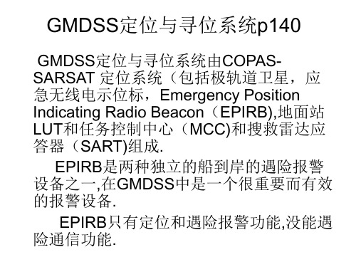
GMDSS定位与寻位系统p140
GMDSS定位与寻位系统由COPASSARSAT 定位系统(包括极轨道卫星,应 急无线电示位标,Emergency Position Indicating Radio Beacon(EPIRB),地面站 LUT和任务控制中心(MCC)和搜救雷达应 答器(SART)组成.
二.COSPAS-SARSAT系统中的信标
• (一).船用EPIRB是用于水上移动业务的信标,其主 频是406.025MHZ;功率为5W;可以连续以50秒发 射0.5秒的周期,发射48小时.它还同时具有121.5 MHZ的发射频率,但这个频率主要用于让飞机寻位 用.
• (二).ELT是用于航空移动业务的信标,其主频是 121.5MHZ,功率为50-100mW.
• (三).PLB是用于个人陆地移动的信标,其主频是 406MHZ.
• 注意: EPIRB/PLB因为采用的是406MHZ,所以其 检测方式有两种,即全球模式(存储转发)与实时 (本地)模式两种;而ELT只有实时(本地)模式一种.
COSPAS-SARSAT系统的工作原理
• 定位原理:当多普勒频移定位的两个位置的距离 越来越近时,可确定卫星轨道左面的是真位置, 右面是镜像位置;
COSPAS-SARSAT系统组成功能
业务名称英汉对照
ARQ Automatic Repetition Request 自动请求重复DSC Digital Selective Calling 数字选择性呼叫EGC Enhanced Group Call 增强群呼EPIRB Emergency Position Indicating Radio Beacon 应急无线电示位标FEC Forward Error Correction 前向纠错GMDSS Global Maritime Distress and Safety System 全球海上遇险与安全系统IMO International Maritime Organization 国际海事组织INMARSAT International Maritime Satellite Organization 国际海事卫星组织MID Maritime Identification Digits 海上识别数字MMSI Maritime Mobile Service Identities水上移动业务识别码MSI Maritime Safety Information 海上安全信息NAVTEX Navigational Telex 航行警告电传NBDP Narrow Band Direct Printing Telegraph 窄带直接印字电报SARSAT Search and Rescue Satellite Aided Tracking 搜救卫星救助跟踪系统SART Search and Rescue Radar Transponder搜救雷达应答器SSB Single Side Band 单边带SOLAS International Convention for Safety of Life at sea 国际海上人命安全公约STCW International Convention on Standard of Training Certification and Watch-keeping for Seafarers海员培训、发证和值班标准国际公约VHF very High Frequency 甚高频AGC Automatic Gain Control 自动增益控制ALRS Admiralty List Of Radio Signals 无线电信号表AMVER Automated Mutual-assistance Vessel Rescue System 船舶自动互救系统CFEC Colective FEC 集群行前向纠错GEOSAR Geostationary Search and Rescue System 同步轨道卫星搜救系统ITU International Telecommunication Union 国际电信联盟LEOSAR Low-altitude Earth Orbit System for Search and Rescue 近极轨道卫星搜救系统LES/CES Land/Coast Earth Station 陆地(海岸)地球站MES Mobile Earth Station 陆用移动站SES Ship Earth Station 海用移动站MCC Mission Control Centers 任务控制中心(M)RCC (Maritime)Rescue Coordination Center (海上搜救中心)搜救协调中心NAVAREA Navigational Area 航警区域NCS Network Coordination Station 网络协调站NOC Network Operation Center 网络控制中心SCC Satellite Control Centre 卫星控制中心UTC Coordinated Universal time 协调世界时WWNWS World Wide Navigational Warning Services 世界航警业务。
LowEarthOrbit(LEO)500-2,000kmabovetheearth
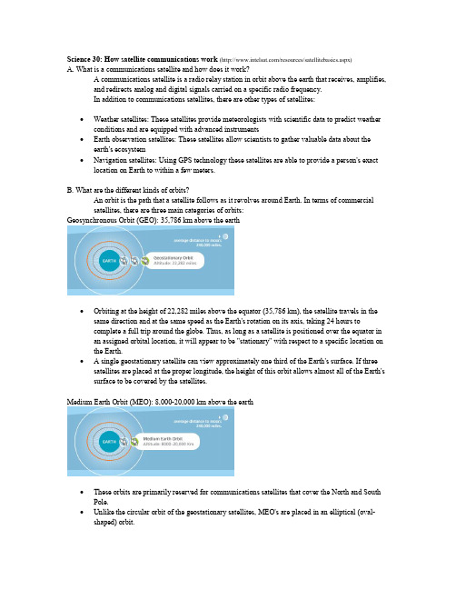
Science 30:How satellite communications work (/resources/satellitebasics.aspx)A. What is a communications satellite and how does it work?A communications satellite is a radio relay station in orbit above the earth that receives, amplifies,and redirects analog and digital signals carried on a specific radio frequency.In addition to communications satellites, there are other types of satellites:· Weather satellites: These satellites provide meteorologists with scientific data to predict weather conditions and are equipped with advanced instruments· Earth observation satellites: These satellites allow scientists to gather valuable data about the earth's ecosystem· Navigation satellites: Using GPS technology these satellites are able to provide a person's exact location on Earth to within a few meters.B. What are the different kinds of orbits?An orbit is the path that a satellite follows as it revolves around Earth. In terms of commercialsatellites, there are three main categories of orbits:Geosynchronous Orbit (GEO): 35,786 km above the earth· Orbiting at the height of 22,282 miles above the equator (35,786 km),the satellite travels in the same direction and at the same speed as the Earth's rotation on its axis, taking 24 hours tocomplete a full trip around the globe. Thus, as long as a satellite is positioned over the equator in an assigned orbital location, it will appear to be "stationary" with respect to a specific location on the Earth.· A single geostationary satellite can view approximately one third of the Earth's surface. If three satellites are placed at the proper longitude, the height of this orbit allows almost all of the Earth's surface to be covered by the satellites.Medium Earth Orbit (MEO): 8,00020,000 km above the earth· These orbits are primarily reserved for communications satellites that cover the North and South Pole.· Unlike the circular orbit of the geostationary satellites, MEO's are placed in an elliptical (oval shaped) orbit.Low Earth Orbit (LEO): 5002,000 km above the earth· These orbits are much closer to the Earth, requiring satellites to travel at a very high speed in order to avoid being pulled out of orbit by Earth's gravity.· At LEO, a satellite can circle the Earth in approximately one and a half hours.GEO vs. LEO vs. MEOMost communications satellites in use today for commercial purposes are placed in the geostationary orbit, because of the following advantages:1. One satellite can cover almost 1/3 of Earth's surface, offering a reach far more extensive than whatany terrestrial network can achieve.2. Communications require the use of fixed antennas. Since geosynchronous satellites remainstationary over the same orbital location, users can point their satellite dishes in the right direction, without costly tracking activities, making communications reliable and secure.3. GEO satellites are proven, reliable and securewith a lifespan of 1015 years.C. Satellite architectureCommunications data passes through a satellite using a signal path known as a transponder. Typically satellites have between 24 and 72 transponders. A single transponder is capable of handling up to 155 million bits of information per second. With this immense capacity, today's communication satellites are an ideal medium for transmitting and receiving almost any kind of contentfrom simple voice or data to the most complex and bandwidthintensive video, audio and Internet content.Diagrammatic Representation of a SatelliteD. Orbital location and footprintThe location of a geostationary satellite is referred to as its orbital location., International satellites, are normally measured in terms of longitudinal degrees East (° E) from the Prime Meridian of 0¼ (for example, Intelsat satellite 805 is currently located at 304.5° E).The geographic area of the Earth's surface over which a satellite can transmit to, or receive from, is called the satellite's "footprint." The footprint can be tailored to include beams with different frequencies and power levels.E. Frequency bands and beamsSatellites transmit information within radio frequency bands. The frequency bands most used by satellite communications companies are called Cband and the higher Kuband. Over the next several years, the use of a higher frequency band known as Kaband is expected to increase. Modern satellites are designed to focus on different ranges of frequency bands and different power levels at particular geographic areas. These focus areas are called beams. Intelsat offers four beam types:· Global: covering almost 1/3 of Earth's surface· Hemi: covering almost 1/6 of Earth's surface· Zone: covering a large landmass area· Spot: covering a specific geographic areaF. What is installed on the ground?All communications with a geostationary satellite require using an earth station or antenna. Earth Stations may be either fixed (installed at a specific location) or mobile for uses such as Satellite News Gathering (SNG) or maritime applications. Antennas range in size, from large telecommunications carrier dishes of 4.5 to 15 meters in diameter, to VSAT antennas which can be as small as under one meter, designed to support services such as Direct to Home TV (DTH) and rural telephony.The antenna, itself, will generally be connected to equipment indoors called an indoor unit (IDU), which then connects either to the actual communications devices being used, to a Local Area Network (LAN), or to additional terrestrial network infrastructure.Satellite Discussion Questions1. Identify the four different types of satellites.2. Calculate the gravitational force between Earth and a geostationary satellite that weighs 560 kg.3. Explain why satellites do not fall back to Earth.4. Weather satellites may detect infrared radiation emitted by Earth,and from this infer the degree ofcloud cover.a) Design a satellite based study that could be performed to analyze locations within Canadathat might be ideal sites to build a solar farm electrical generating facility.b) Identify two additional factors that should be considered prior to building a solar powergenerating station at the ideal site.5. a) Calculate the wavelength of a communications satellite that broadcasts at 4.6 GHz (gigahertz).6. Considering that geostationary satellites are “stationary” relative to the Earth,identify how usingsolar energy as a power source would be a concern and describe how this could be overcome(consider the “diagrammatic representation of a satellite”).b) Identify the type of electromagnetic radiation broadcast by this satellite.7. Hypothesize on some future uses of satellites.8. Evaluate the societal impact of using satellites by describing one societal advantage and onesocietal disadvantage.。
卫星搜救系统及EPIRB的安装与操作
【知识链接】
• 一、406 MHz EPIRB的概述 • 1.406 MHz EPIRB简介 • 船用EPIRB一般内装两个发射机,406 MHz发射机和121.5/243 MHz
发射机(121. 5 MHz和243 MHz EPIRB不是强制的),用于发射遇险报 警信号。同时,121.5/243 MHz发射机发射的信号还可作为搜救飞机 和搜救船舶的寻位信号。 • 在船上的406 MHz EPIRB要求安装在自浮式支架上,并能人工启动 和自动启动。EPIRB示位标启动后,每50*发射一次0. 5 s、功率为5 W的射频脉冲。EPIRB的电池使用年限为4年,电池容量为48 h。自 • 浮式支架上的静水压力释放器使用年限为2年。图6一5为两种应急示 位标外形。
行中继的L波段EPIRB,但INMARSAT系统在2006年就已经停止对1. 6 GHz EPIRB的服务。 • 406 MHz EPIRB,工作频率406 MHz,同时含有载颇为121.5/243 MHz自引导信号,它是COSPAS/SARSAT系统的船上终端设备。目 前GMDSS系统中使用的应急示位标只有这一种,SOLAS公约要求所 有船舶配备自浮式406 MHz EPIRB
【知识链接】
• 2.手动启动 • 手动启动是指人为地将示位标从安放支架或存放盒中取出,手动启动
示位标的遇险报警功能,使示位标开始发射遇险信号。 • 三、应急示位标的维护保养 • 应急示位标的维护保养主要包括一些部件的更换及日常维护保养。 • 1.部件的更换 • 部件的更换主要指电池和静水压力释放器。
上一页 下一页 返回
上一页 下一页 返回
【知识链接】
• 2. EPERB的装船注册 • 如果船舶要配备EPIRB,应及时向有关机构注册。 • 注册的内容都在注册卡上标明,主要包括装船EPIRB的出厂序列号,
SARscape中SAR数据的配准

SARscape中SAR数据的配准覆盖同⼀地区的多幅雷达影像,如要进⾏时间序列分析、动态监测、多时相滤波处理等,需要进⾏图像间的配准处理。
雷达⼲涉处理时,复数据的配准也是必不可少的⼀步,SARscape提供配准功能,可以对SAR数据进⾏配准。
雷达数据的配准处理要求数据是斜距⼏何,并且各个图像采⽤相同的拍摄模式。
配准不同于地理编码,地理编码是将每个像素从斜距⼏何转化为地图投影。
SAR数据的配准使⽤了交叉相⼲法(Cross-correlation),全⾃动的进⾏,程序运⾏的过程有以下⼏步:l 根据轨道参数和DEM计算局部⾮参数偏移估计。
如果轨道不准确,则使⽤⼀个⼤的⼼窗⼝(central window)来估算。
l ⾃动从参考图像和待配准图像上选择⼀组⼦窗⼝(交叉相关格⽹)。
l 计算两个图像⼦窗⼝中相应像素之间的交叉相关函数。
l 交叉相关函数的最⼤值表⽰最适合在⽅位和距离向上的局部像素偏移,达到亚像元配准精度。
l 根据⽅位⾓和距离像元位置,通过多项式计算残差偏移参数,并将其与原始局部⾮参数估计相加。
l 如果输⼊的SAR数据是SLC,则通过在分布在整个图像的⼩窗⼝(精细偏移参数)上计算“微型⼲涉图”来进⼀步细化残差参数偏移。
如果相⼲性过低,⽤于精细偏移估计的点数可能不⾜以优化共配准过程。
在这种情况下,将使⽤局部⾮参数偏移和改进的基于互相关的拟合(精细偏移参数>互相关采样)来进⾏共配,计算出最⼤的复相⼲,进⼀步计算偏移,达到1/100像元精度;否则利⽤抽样数据进⼀步计算偏移,达到1/10像元精度。
1、SARscape中的配准⼯具介绍SARscape中的配准⼯具是:/SARscape/Basic/Intensity Processing/Coregistration,该⼯具可⽤于多时相强度数据配准,也可⽤于多时相SLC数据配准,⼯具数据输⼊界⾯和参数界⾯如下:图配准⼯具界⾯l 数据输⼊(Input Files)⾯板:• Input Reference File下,从多张影像中选择⼀幅SAR影像作为基准(Input Reference File),如果没有特殊要求,⼀般按照时间顺序,选择第⼀个时相的数据作为基准影像。
空间激光通信

空间激光通信研究现状空间激光通信相对射频通信有着速率高、容量大等许多优点,从上世纪80年代起,各国就陆续开展了对空间激光通信的研究。
目前,各国激光通信的调制方式主要分为PPM、PSK和OOK三种,本文按照调制方式对各国的空间激光通信研究现状进行描述。
1,PPM欧洲的SILEX项目、OPTEL项目和美国的LLCD项目、LCRD项目、MLCD项目使用或部分使用PPM调制方式。
1.1,LLCD项目[1~3]LLCD是美国NASA2013年开始实行的一个项目,该项目建了两个探测器,月球环境探测器LLST和地面站LLGT,LLST和LLGT的通信距离距离在35000~400000km之间。
如图1(1)所示,地面站LLGT重达7吨,有4个15cm发射镜头和4个40cm接收镜头组成。
LLGT的发射机使用的调制方式为4-PPM,每4个数据时隙后跟有12个或者28个静默时隙,发射激光器的波长是1550nm,通过4个发射镜头实现4路时分复用,信号发射前经过一个10W光放大器放大,传输速率为10/20Mbps,这个速度是目前地月RF通信的5000倍。
为降低误码率采用了turbo码作为信道编码,码率为1/2,实现了0误码。
4路接收镜头阵列有效提高了接收信号强度,接收机是4个超导单光子计数探测器(工作在3K温度上),接收灵敏度极高,如图1(2)所示,能够提供高速光子计数测量[1]。
月球探测器LLST由光学模块、调制解调器、电子控制器三个模块组成[2],质量30kg。
光学模块由一个10cm镜头的镜头组成,完成发射和接收光信号的功能,光学模块安装在一个二轴平衡台上,台上有粗瞄准和捕获探测器,该模块能够测试飞船的振动并进行补偿,实现对地面站的瞄准和捕获,光学模块通过光纤耦合到调制解调模块上。
调制解调模块的主要功能是调制和解调光信号,如图2所示,模块内置了311MHz低噪声时钟(经VCO可倍频至5GHz),解调模块前置了一个0.5W的放大器,对接收光信号进行放大,光信号进入后一部分经PLL使时钟频率同步,一部分进入解调器,解调器的时隙时钟由频率同步后的时钟提供(不需要额外的时隙同步),FPGA的主要作用是上行链路帧同步,下行链路产生帧信号发送出去[3]。
中轨SAR系统设计及关键技术研究
中轨SAR系统设计及关键技术研究谈璐璐;盛磊【摘要】中轨SAR(MeoSAR)作为低轨SAR (LeoSAR)和高轨SAR(GeoSAR)的折中,具有观测范围广、时间分辨率高的特点,是极具应用前景的新型SAR系统.根据中轨SAR的系统特点及优势,对中轨SAR系统设计中的成像体制选择、工作参数选择、成像模式设计等进行了论述.针对中轨SAR系统存在的特殊问题,对中轨SAR的关键技术问题进行分析,提出了基于波束赋形的距离模糊抑制方法和高精度时域成像算法,并对中轨SAR天线设计和空间环境设计的难点进行了总结.研究结果为中轨SAR系统实现及应用提供有益参考.%MeoSAR is the spaceborne SAR with orbit height between 3 000 km and 10 000 km.MeoSAR is a compromise between GeoSAR and LeoSAR for its powerful observation capability and less challenging technology difficulties.It is very promising for earth observation.Concepts and system design considerations of MeoSAR are investigated and some technology challenges are discussed.A range ambiguity suppression method based on antenna shaping and a high precision time-domain imaging algorithm are proposed.Moreover,the difficulties of antenna design and space environment adaptability are discussed.The investigation can be referenced for the MeoSAR system design and applications.【期刊名称】《雷达科学与技术》【年(卷),期】2017(015)002【总页数】6页(P148-152,158)【关键词】中轨SAR;高分辨率宽覆盖;系统设计;模糊抑制;成像算法【作者】谈璐璐;盛磊【作者单位】中国电子科技集团公司第三十八研究所,安徽合肥230088;孔径阵列与空间探测安徽省重点实验室,安徽合肥230088;中国电子科技集团公司第三十八研究所,安徽合肥230088;孔径阵列与空间探测安徽省重点实验室,安徽合肥230088【正文语种】中文【中图分类】TN958星载合成孔径雷达(Synthetic Aperture Radar,SAR)作为宽幅主动微波成像设备,不仅具有可见光和红外遥感器所不具有的全天时和全天候观测能力,而且具有雷达高度计和微波辐射计不具有的高空间分辨率信息获取能力,在军事侦察,地形测绘,灾害监测,洋流、冰川、风浪监测,路上、海上交通管制,农林监测等领域,都具有重要的应用价值和广阔的发展前景。
- 1、下载文档前请自行甄别文档内容的完整性,平台不提供额外的编辑、内容补充、找答案等附加服务。
- 2、"仅部分预览"的文档,不可在线预览部分如存在完整性等问题,可反馈申请退款(可完整预览的文档不适用该条件!)。
- 3、如文档侵犯您的权益,请联系客服反馈,我们会尽快为您处理(人工客服工作时间:9:00-18:30)。
146Strong planning under uncertainty in domains with numerous but identicalelements (a generic approach)Original Research ArticleTheoretical Computer Science, Volume 379, Issues 1-2, 12 June 2007, Pages84-119Max Kanovich, Jacqueline VauzeillesShow preview | Purchase PDF (619 K) | Related articles | Related reference work articles147Advanced budgeting: a journey to advanced management systems Original Research ArticleManagement Accounting Research, Volume 6, Issue 3, September 1995, Pages 253-265Peter Bunce, Robin Fraser, Lionel WoodcockClose preview | Purchase PDF (449 K) | Related articles | Related reference work articlesAbstractAbstractThis paper summarizes a journey that has taken the CAM-I advanced management systems (AMS) program's Advanced Budgeting study group from an initial interest in better budgeting towards a recognition that a wider framework is needed to meet wider objectives (Woodcock, 1994). The work in advanced budgeting started from two different approaches. The first evolved from CAM-I's research into the application of activity-based costing (ABC) to product costing, during which the group became convinced that it could be applied with benefit to activity planning and budgeting. The second approach came from a recognition that the ultimate purpose of a management system is to link strategies and operations in the most effective way. As strategies are changing in response to many competitive and structural pressures, it seems evident that new management systems are needed to reflect these new realities. An initial conceptual framework for advanced budgeting was developed and tested with field visits. As a result, it was concluded that traditional budgeting is dysfunctional, but the solution is not better budgeting nor stand-alone advanced budgetingsystems. Rather, the advanced budgeting key goals can only be achieved through anadvanced management system which has a business process orientation and integrates anumber of different management functions and initiatives within an on-going system. Thiswill require significant changes in systems and culture. The work can be seen in retrospectas an accumulation of knowledge about the advanced management systems that will beneeded to meet the challenges and opportunities of a new and volatile market place. Withthat broader objective now in focus, it can be seen that an important staging has beenreached, but that the journey continue.On the technical and economic issues involved in the co-firing of coal and waste in148a conventional pf-fired power station Original Research ArticleFuel, Volume 83, Issues 7-8, May 2004, Pages 905-915S. N. Ireland, B. Mcgrellis, N. HarperClose preview | Purchase PDF (333 K) | Related articles | Related reference work articlesAbstract | Figures/Tables | ReferencesAbstractThe introduction of co-firing schemes to large-scale utility plant has to date been limited inthe UK. The need to conform to ever more stringent emissions legislation, reduced levels ofcarbon dioxide (CO2), and the recently introduced Renewables Obligations Certificates(ROCs) means that conventional power stations are having to change their operatingphilosophy and encompass new technologies and operating techniques.The current paper describes some of the key work associated with the feasibility, design,and construction stages of a 100,000 tonne/annum dried sewage sludge co-firing facilityattached to an existing 2,400 MWe pf-fired power station. The scheme is one of the first ofits type and the largest in the UK, and represents an important milestone in the complexprogress of integrating a biomass fuel with a conventional boiler process.Critical steps in the initial feasibility phase of the design process are described, such as thedetailed evaluation of the raw materials suitability for co-firing in terms of the chemical andphysical properties of the waste fuel. The resultant raw material properties are presentedas input data to a detailed computer model developed by Sinclair Knight Merz (Europe) Ltd, the output of which indicates the co-firing potential of the composite fuel with respect to its impact on plant efficiency, thermal balance, flue gas characteristics, system performance (throughput, materials and maintenance) and potential for environmental impact. Specific areas of interest are highlighted such as fuel volatility, emission levels, trace element partitioning, ash composition and behaviour, fouling and slagging mechanisms and predicted erosion and corrosion levels.Consenting requirements of the co-firing schemes have also been considered, with the Integrated Pollution Control (IPC), Integrated Pollution Prevention and Control (IPPC), Town and Country Planning and the Electricity Act (Section 36 Consent) being examined. Article OutlineNomenclature1. Introduction2. Fuel availability3. Fuel characterisation4. Co-firing potential5. Fuel handling6. Flue gas characteristics and emissions7. Plant operational issues8. Consenting and environmental constraints9. Summary and conclusionsAcknowledgementsReferences149Aging management of containment structures in nuclear power plants Original Research ArticleNuclear Engineering and Design, Volume 166, Issue 3, 1 November 1996, Pages 367-379D. J. Naus, C. B. Oland, B. R. Ellingwood, H. L. Graves III, W.E. NorrisClose preview | Purchase PDF (1102 K) | Related articles | Related reference work articlesAbstract | ReferencesAbstractResearch is being conducted by Oak Ridge National Laboratory under US Nuclear Regulatory commission (USNRC) sponsorship to address aging management of nuclear power plant containment and other safety-related structures. Documentation is being prepared to provide the USNRC with potential structural safety issues and acceptance criteria for use in continued service evaluations of nuclear power plants. Accomplishments include development of a Structural Materials Information Center containing data and information on the time variation of 144 material properties under the influence of pertinent environmental stressors or aging factors, evaluation of models for potential concrete containment degradation factors, development of a procedure to identify critical structures and degradation factors important to aging management, evaluations of non-destructive evaluation techniques, assessments of European and North American repair practices for concrete, review of parameters affecting corrosion of metals embedded in concrete, and development of methodologies for making current condition assessments and service life predictions of new or existing reinforced concrete structures in nuclear power plants. Article Outline• References150Quantitative examinations for multi joint arm trajectory planning—using a robust calculation algorithm of the minimum commanded torque change trajectory Original Research ArticleNeural Networks, Volume 14, Issues 4-5, May 2001, Pages 381-393 Yasuhiro Wada, Yuichi Kaneko, Eri Nakano, Rieko Osu, Mitsuo KawatoClose preview | Purchase PDF (335 K) | Related articles | Related reference workarticlesAbstract | Figures/Tables | ReferencesAbstractIn previous research, criteria based on optimal theories were examined to explain trajectory features in time and space in multi joint arm movement. Four criteria have been proposed. They were the minimum hand jerk criterion (by which a trajectory is planned in an extrinsic-kinematic space), the minimum angle jerk criterion (which is planned in an intrinsic-kinematic space), the minimum torque change criterion (where control objects are joint links; it is planned in an intrinsic-dynamic-mechanical space), and the minimum commanded torque change criterion (which is planned in an intrinsic space considering the arm and muscle dynamics). Which of these is proper as a criterion for trajectory planning in the central nervous system has been investigated by comparing predicted trajectories based on these criteria with previously measured trajectories. Optimal trajectories based on the two former criteria can be calculated analytically. In contrast, optimal trajectories based on the minimum commanded torque change criterion are difficult to be calculated, even with numerical methods. In some cases, they can be computed by a Newton-like method or a steepest descent method combined with a penalty method. However, for a realistic physical parameter range, the former becomes unstable quite often and the latter is unreliable about the optimality of the obtained solution.In this paper, we propose a new method to stably calculate optimal trajectories based on the minimum commanded torque change criterion. The method can obtain trajectories satisfying Euler–Poisson equations with a sufficiently high accuracy. In the method, a joint angle trajectory, which satisfies the boundary conditions strictly, is expressed by using orthogonal polynomials. The coefficients of the orthogonal polynomials are estimated by using a linear iterative calculation so as to satisfy the Euler–Poisson equations with a sufficiently high accuracy. In numerical experiments, we show that the optimal solution can be computed in a wide work space and can also be obtained in a short time compared with the previous methods.Finally, we perform supplementary examinations of the experiments by Nakano, Imamizu, Osu, Uno, Gomi, Yoshioka et al. (1999). Estimation of dynamic joint torques and trajectoryformation from surface electromyography signals using a neural network model. Biological Cybernetics, 73, 291–300. Their experiments showed that the measured trajectory is the closest to the minimum commanded torque change trajectory by statistical examination of many point-to-point trajectories over a wide range in a horizontal and sagittal work space. We recalculated the minimum commanded torque change trajectory using the proposed method, and performed the same examinations as previous investigations. As a result, it could be reconfirmed that the measured trajectory is closest to the minimum commanded torque change trajectory previously reported.Article Outline1. Introduction2. Optimal criteria for trajectory planning and calculation algorithm2.1. Minimum hand jerk criterion2.2. Minimum angle jerk criterion2.3. Minimum torque change criterion2.4. Minimum commanded torque change criterion3. A prediction algorithm for trajectories based on the minimum commanded torque change criterion using the Euler–Poisson equation3.1. Euler–Poisson equation3.2. A system of orthogonal polynomials for expression of the minimum commanded torque change trajectory3.2.1. A difference trajectory Δθi(t)3.3. An estimation algorithm of parameter a ik3.3.1. A linear summation concerning parameter a ik3.3.2. A discretization of the movement time4. Numerical experiments of point-to-point movement on the horizontal and sagittal planes5. Consideration6. SummaryAcknowledgementsAppendix A. AppendixA.1. Jacobian polynomialA.2. Jacobian polynomial of k+1Appendix B. Quantitative examination of the spatial and time features of trajectoriesReferencesresults 126 - 150404 articles found for: pub-date > 1994 and tak(((Large shopping mall) or (department store manager) or (property management) or (planning work) or wholesale or (retail business center)) and (Fashion or (shopping area) or private or companies or building or new or consumer or services) and (underground or city or life or (fashion fun) or Forefront or planning or concepts or covering or variety or business) and (conditions or ground or indoor or (ice skating) or rink or country's or first or "world-class" or Alibaba or "Large-scale" or theme or park or entertainment) and (children or entertainment or center or form or unprecedented or "large-scale" or new or pattern or consumption or car))Edit this search | Save this search | Save as search alert | RSS FeedClose preview | Purchase PDF (261 K) | Related articles | Related reference work articlesAbstract | Figures/Tables | ReferencesAbstractGeosynchronous orbits have the unique characteristic that their orbital period is equal to one sidereal day. This configuration does provide coverage on a regional scale. This is a potential advantage in terms of system usage as the demand for some satellite services is concentrated in certain regions of the globe. This paper investigates both active and passive configurations, highlighting their different features and advantages. A synthetic aperture radar (SAR) simulator has been developed to study the influence of integration time on SAR processing in both low earth orbit (LEO) and geosynchronous SAR (GeoSAR) configurations. Different scenarios with targets affected by noise sources with various decorrelation time have been simulated in order to test the system response. Simulations show that in a geosynchronousSAR the long integration time averages out non-stationary signals within the resolution cell converting their influence to background clutter. Indeed, noise rejection is effective even if noise amplitude is one order of magnitude larger than the signal itself.The features that have been demonstrated via numerical simulations could be exploited in new SAR applications. SAR interferometry can benefit of the increased temporal correlation as all the high frequency components of interferometric phase noise have been previously filtered out. Fine temporal sampling is a feature that might be exploited for disaster management and might lead to major advances in the understanding of rapidly evolving phenomena on the ground surface. Future applications can be foreseen also in soil moisture retrieval and other related agricultural applications.Article Outline1. Introduction2. Geosynchronous SAR characteristics2.1. Coverage2.2. Orbit characteristics2.3. Target coherence and noise rejection3. Active systems4. Passive systems5. Multistatic SAR6. Applications6.1. Interferometry6.2. Soil moisture detection7. ConclusionsAcknowledgementsReferencesClose preview | Purchase PDF (960 K) | Related articles | Related reference work articlesAbstract | Figures/Tables | ReferencesAbstractExperiments have been performed to study pedestrian flow through bottlenecks under oversaturated conditions. The data underline a new phenomenon in pedestrian flows: when high-density conditions occur upstream of a bottleneck, the maximum capacity of the bottleneck (i.e. the maximum number of pedestrians that can flow through the bottleneck in a given time interval) can drop. This is referred to as “capacity drop” and should be carefully taken into account when dealing with building evacuation philosophy.Controlling the population density upstream of a bottleneck can maximise the flow through it (i.e. by avoiding capacity drop) and shorten the building evacuation time significantly. This paper focuses on alarm times and egress routes (in terms of their geometrical characteristics like length, width) as means for controlling population densities and therefore reducing building evacuation time.Specifically, the proposed methodology includes an optimisation algorithm that explores the research space (defined by all the possible Route-Alarm Time schedule plans where a Route-Alarm Time schedule plan is in turn defined by a set of alarm times and a set of egress routes) and aims to find the Route-Alarm Time schedule plan that minimises the building evacuation time. We call building evacuation time the temporal gap between the time the first person starts to egress the building until all people have reached an area of safety outside the building.A newly proposed movement model, embedded into the optimisation algorithm, allows the building evacuation time for a given Route-Alarm Time schedule plan to be assessed by simulating the egress dynamics.This movement model is able to reproduce the capacity drop phenomenon observed in the experimental work and can therefore assess the building evacuation time taking into account the capacities of the various bottlenecks adjusted to take into account the actual upstream densities.The optimisation algorithm, with the movement model embedded in it, has been implemented in an object-oriented simulator.The Route-Alarm Time schedule planning refers to a phased evacuation in a static environment where all the egress paths are viable and the pedestrian population is well-trained.Article Outline1. Introduction1.1. Capacity and the capacity drop phenomenon1.2. Building evacuation and Route-Alarm Time schedule planning2. Empirical evidence of capacity drop3. The movement model4. Optimisation4.1. The research space4.1.1. Feasible sets of egress routes4.1.2. Feasible sets of alarm times4.2. The overall optimisation problem4.2.1. The lower level problem4.2.1.1. Transition rule4.2.1.2. SA4.2.2. The upper level problem5. Case study6. ConclusionAcknowledgementsReferencesVitae事事向上司汇报是对还是错?日前,在前程无忧的论坛上有一则题为“有必要做任何工作前都向领导汇报吗?”的投票帖,从该投票调查中发现,67.65%的人表示“没必要”,其余32.35%的人则认为“应该这么做”。