佳明手持GPS 产品特点表
GARMIN 佳明 eTrex 10 手持GPS导航仪

?面积测绘:提供多种测量面积的类型,精准面积和长度测量与实时显示,并具备中途暂停及开关机仍可接续测量功能。
?航迹测量:测量使用者持设备行走轨迹所围成区域的ቤተ መጻሕፍቲ ባይዱ积(起终点以直线连接)。
?航线测量:使用者创建一条航线,来计算该航线所围成区域的面积。
?等宽测量:依据使用者所输入固定宽度,结合手持设备所行走的轨迹来计算面积(宽度乘以轨迹长度)。
佳明 eTrex 10 手持GPS导航仪
野外采集与面积测量专家:高灵敏度新世代双星(GPS+GLONASS)快速定位能力、超过48颗卫星为您服务、
多种坐标系统与格式转换、 专业面积测亩功能、重量轻又省电、坚固三防设计。
?双星接收:可同时接收GPS和GLONASS两大卫星系统,定位更快更准。
?坐标系统:具备北京54,西安80和CGCS2000等坐标系统与显示格式。
?航迹记录:时间间隔、距离间隔、自动等多种航迹记录模式,满足不同条件下的各种需求。
?低耗电量:两节5号电池,可持续使用25小时以上(较传统产品省电50%)。
佳明 eTrex 10 gps手持机携带方面,家里收割庄稼用的还是土地局时都可以测量面积,无论你是做工程还是旅游都可以定位使用,使用方便,简单易学。
GARMIN佳明eTrex20中文使用手册
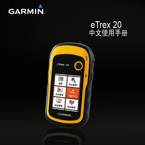
知识产权声明
本机功能及内容仅提供本产品购买人使用,不得私自转载、转 印、复制、更改内容、扫描储存提供给他人,或用作其他用 途。本机所标示的商品文字或图片仅为说明辅助的用途,并非 作为商标使用,原商品商标的知识产权仍为原权利人所有。
eTrex 20 中文使用手册 Nhomakorabea1
注意事项
注意事项
全球卫星定位系统(Global Positioning System,GPS),由美 国国防部研发及管理,并负责该系统的正常运作及定位精度
第六章 坐标转换.........................................................37 第七章 航迹功能.........................................................39
7.1 航迹记录 ............................................................................39 7.2 航迹设置 ............................................................................39 7.3 储存航迹设定 ....................................................................41
7. 本中文说明书仅适用于eTrex 20简体中文版,并不适用于其 他语言版本的机器,产品功能以实际销售的情况为准,请 注意。
上海佳明航电企业管理有限公司
Garmin China Shanghai RHQ Co., Ltd.
上海市徐汇区桂平路391号新漕河泾国际商务中心A座37楼
Garmin 手持GPS型号、专业术语大全

航线方向
航向 停止时间 移动时间 总时间 高度
出发点与目标点间的相对方位角度。
当前的移动方向。 航程中,静止不动的累计时间。 航程中,移动状态的累计时间。 累计的总行程时间。 接收机计算出来的高度值。
坐标(经纬度) 经纬度坐标数值 里程表 速度 平均移动速度 全程平均速度 偏航距 全部行程的距离累积,如车辆的里程表。 当前的行进速度。 行程中,移动状态下的平均速度。 全部行程所计算出的平均速度。
2度变化图
查看高度
按时间高度变化图
查看气压变化图
气压高度计的作用: GPS测量高程的误差大约是水平误差的2倍, 气压计通过感受周围气压的变化来计算高度的变化, 是不依赖于GPS而独立工作的。 注意飞机上的使用。
高度设置选项 25
校准气压测高计
同一地点在不同时刻的气压都可能 是不同的,所以需要时常校准。
1.
2.
3.
航线测面积主要应用于规则区域的面积测量, 例如是一个多边形。本机可测量多至250边的多 边形面积。 如果您已知被测区域各个顶点的坐标,则您无 须实地测量,将这些顶点输入到机器中保存为 航点,然后再依次编辑到同一条航线中,即可 自动计算出面积设臵。 航点的顺序要保证是沿着被测区域周边依次排 列,如果机内航点的前后顺序与实际不符,则 测量结果将可能不准确。
CEP——圆概率误差~50% RMS——均方根误差 ~ 68.26% 2 ~ 95.44% 3 ~ 99.72%
21
GARMIN手持机的定位精度:
标称值:
<10 meters, 95% typical
实测值:
Horizontal CEP 2.2 meters Horizontal RMS 3.0 meters Horizontal 95% 5.9 meters Vertical RMS 3.5 meters Vertical 95% 7.4 meters
功能升级GarminForerunner智能手表全面解析

功能升级GarminForerunner智能手表全面解析Garmin Forerunner智能手表是一款功能强大的智能手表,能够满足运动爱好者的各种需求。
最新的功能升级让这款智能手表更加出色,本文将对Garmin Forerunner智能手表的功能进行全面解析。
一、GPS定位功能Garmin Forerunner智能手表搭载了高精度的GPS定位系统,可以提供准确的定位功能。
无论是户外运动还是室内运动,都能够通过GPS 定位准确记录用户的运动轨迹,并且能够计算出运动的距离和速度,为用户提供详尽的运动数据。
二、心率监测功能心率监测是运动过程中非常重要的指标之一,Garmin Forerunner智能手表具备精准的心率监测功能。
通过内置的光学心率传感器,可以实时监测用户的心率变化,并将数据展示在手表屏幕上。
用户可以根据心率变化调整运动强度,以达到更好的运动效果。
三、睡眠监测功能除了运动监测,Garmin Forerunner智能手表还具备睡眠监测功能。
它可以通过内置的加速度传感器对用户的睡眠状态进行实时监测,并能够自动识别用户的睡眠时间和睡眠质量。
通过这项功能,用户可以了解自己的睡眠情况,并根据睡眠数据进行合理的调整,以提高睡眠质量。
四、智能通知功能Garmin Forerunner智能手表支持与手机的连接,可以接收来自手机的各种通知,如来电、短信、社交媒体消息等。
用户只需将手表与手机配对,即可在手表屏幕上方便地查看通知内容,不再错过任何重要信息。
五、音乐控制功能对于喜欢在运动时听歌的用户来说,Garmin Forerunner智能手表的音乐控制功能将是一大亮点。
用户可以通过手表控制手机上的音乐播放,切换歌曲、调整音量,无需取出手机,方便又实用。
六、多项运动模式Garmin Forerunner智能手表拥有多种运动模式,涵盖了室内跑步、户外跑步、骑行、游泳等众多运动项目。
用户可以根据自己的需求选择相应的运动模式,并通过手表记录运动数据。
佳明运动手表GPS设置说明

佳明运动手表GPS设置说明在如今的运动领域,佳明运动手表以其精准的定位和丰富的功能,成为了众多运动爱好者的得力助手。
而其中,GPS 功能的设置对于获取准确的运动数据至关重要。
接下来,就让我们详细了解一下佳明运动手表的 GPS 设置。
首先,我们要确保手表的电量充足。
因为 GPS 功能的运行会消耗一定的电量,如果电量不足,可能会影响其正常工作,甚至导致定位不准确或中途中断。
打开手表后,找到“设置”选项。
这个选项通常可以通过在主界面上滑动或者点击特定的按钮进入。
进入设置页面后,我们会看到一系列的子选项,其中就包括“GPS”。
点击“GPS”选项,进入到 GPS 设置的详细页面。
在这里,我们首先看到的可能是“GPS 模式”的选择。
佳明运动手表通常提供了多种 GPS 模式,比如“标准模式”、“省电模式”和“高精度模式”。
“标准模式”是一种平衡了精度和电量消耗的模式,适用于大多数日常的运动场景,比如慢跑、骑行等。
如果您只是进行一般性的运动锻炼,并且对精度要求不是特别苛刻,那么选择标准模式就可以满足需求。
“省电模式”则是以降低精度为代价,最大程度地节省手表的电量。
这种模式适合那些运动时间较长,而又不太在意定位精度细微差异的情况,比如进行长距离徒步或者越野跑,当您担心手表电量无法支撑全程时,可以选择此模式。
“高精度模式”顾名思义,能够提供最高精度的定位,但相应地,其电量消耗也是最大的。
如果您进行的是对定位精度要求极高的专业运动,或者是在复杂的环境中运动,比如在高楼林立的城市中跑步或者在山林中越野,那么高精度模式会是更好的选择。
在选择完 GPS 模式后,接下来可能会看到“GPS 卫星系统”的选项。
佳明运动手表一般支持多种卫星系统,如 GPS、GLONASS、Galileo 等。
您可以根据实际情况选择开启单一的卫星系统或者多个卫星系统同时工作。
在开阔的区域,单一的卫星系统可能就足以提供准确的定位;而在信号容易受到干扰的环境,比如山谷、密林等地,选择多个卫星系统同时工作可以提高定位的可靠性。
七款佳明导航仪产品介绍

GPS 接收天线:
内藏式天线 / 支持外接天线
GDR 10(行车记录器)(选购配件):
镜头:
1/4 寸 F=3.1mm
摄影范围:
可视角度为对角线 72 度,水平角度 57 度,垂直角度 41 度
感光元件:
120 万像素 CMOS
蓝牙免提电话:
无
兼容 TMC 交通路况:
无
世界钟,汇率转换
MP3 播放器:
无
语音书播放器:
无
FM 语音发射:
无
耳麦/音频输出:
无
Garmin Lock ™(防盗属性):
无
航位推测:
无
适用于摩托车:
无
适用于卡车:
无
Geocaching 地理藏宝:
无
2 佳明 2555 2555 延续了 Garmin 工艺设计与创新务实的两大优点,可随意搭配多种配件使用,如:行车 记录器、TMC 实时交通路况等。配上 Garmin 既有的专业导航功能与 100%自制景点书,充 份显现了 Garmin 在研究驾驶行为的专业与务实。 nüvi2555 采用 5 英寸屏幕, 强调以”安全”为核心,字体大且清晰,且具有” 个性化主菜单聪 明设定,使用者可以将最常用的功能,编辑放入导航仪主菜单页面,减少操作步骤。并增加 回避区域/道路设置功能、多种导航模式建议路线预览、目的地附近景点搜索等新功能。
蓝牙免提电话: 兼容 FM 交通路况: 图片浏览器: MP3 播放器: 语音书播放器: FM 语音发射: Garmin Lock ™(防盗属性):
无 有(选配) 有 有 无 无 有
5 佳明 3790 nüvi®3790T 预装大陆标准版电子导航地图,高感 GPS 接收模组,可快速完成卫星定位。国 际顶尖设计师全情倾力打造世界上最薄的 GPS 导航仪 nüvi 3790T,动感时尚外形,钢化玻 璃表面,金属拉丝背板,高清高亮度多点触控液晶屏,一举荣获 2010 年德国红点设计大奖。 机身厚度仅有 0.89cm,重量 113.4g,WVGA 分辨率 800×480 电容式触控屏。专为驾车设计
最新-GARMIN(佳明)-中国-手持GPS各型号性能指标对比121207整理
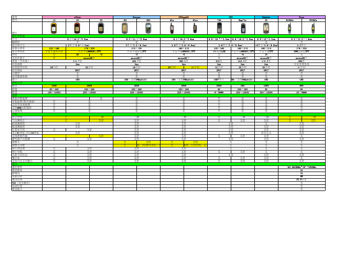
microSD卡 192.7克
2AA 16小时 IPX7
否 是 USB(支持NMEA0183)
2000 200×250 200×10000
是 是 是 是 是
三轴
支持
支持
支持
支持
支持
支持
支持
无
支持
无
像素,4倍数码变焦,自
支持
支持
支持
支持
支持
6.1×16.0×3.6cm
否
2.6英寸(3.6×5.5cm)
128×160 半反半透黑白屏
无 否
25小时
5.4×10.3×3.3cm
否
2.2英寸(3.6×4.3cm)
176×220
半反半透65000色TFT
2G
4G
microSD卡
141.7克
2AA
22小时
IPX7
否
是
USB
1000 50×250 100×10000
2000 200×250 200×10000
3000 50 9×9999
200 200×250 200×10000
1000 50 200×10000
是
否
是
是
是
否
是
是
是
否
是
是
是
否
是
是
是
否
是
是
三轴
支持
支持
支持
支持
支持
支持
支持
无
支持
无
像素,自动对焦,记录
支持
支持
支持
支持
支持
无
三轴
无
佳明手持gps参数

∙品牌: Garmin/佳明
∙定位精度: 3M
∙定位时间: 45秒
∙更新速度: 1次/秒
∙屏幕尺寸: 4.1英寸
∙是否支持背光显示: 是
∙上市时间: 2014年夏季
∙外壳材质: 塑料
∙尺寸: 7.48 x 14.96 x 3.63cm ∙重量: 331g (包含锂电池)
∙是否防水: 是
∙地图类型: 全国地图
∙是否支持加载地图: 是
∙内存容量: 8MB
∙产地: 美国
∙售后服务: 全国联保
∙GPS功能: 气压测高
∙语种分类: 中文英语
∙价格区间(GPS): 3000元以上∙携带方式: 手持式
∙使用方式: 触屏式
∙持续工作时间: 15-20小时
可接收GPS、北斗、GLONASS三大卫星系统信号,覆盖更广,定位更快更准。
安卓开放平台,4英寸彩色液晶触摸屏,强光下清晰可见。
内置三轴电子罗盘、气压式高度计、加速度计、陀螺仪和紫外线感测器,户外应用更可靠。
支持Wi-Fi、蓝牙、ANT+及NFC近场通信技术,传输数据更便捷。
800万像素自动对焦摄像头、防水麦克风、1080p视频拍摄,记录更立体。
预装Garmin独有属性采集软件Sitesurvey,采集作业的最佳之选!。
Garmin GPSMAP 62s 手持导航设备说明书

SI-‐TEX T RAWL P LOT 12SD C OLOR L CD G PS W AAS C HARTING S YSTEM-‐ S pecifications Power Requirement10 -‐35V D C, 15W Display12.1" (diagonal) X VGA C olor L CD T FT Display R esolution800 x 600 p ixels Cartography Four s lots f or h igh-‐definition C -‐MAP M AX/NT+ C -‐Card c artridges Operating Temperature32º t o 131º MemoryNon-‐volatile w ith b attery b ackup TechnologyHigh-‐speed I ntel X scale P rocessor Cursor C ontrolJoystick KeypadS ilicon r ubber, b acklighted Storage C apacityUnlimited w ith o ptional S D m emory c ard Waypoints/Marks5000 Routes50 (100 w pt/route) Track P oints5000 Type o f U ser P oints16 Mark I dentifiersAlphanumeric, P lotting I ntervals—Distance 0.01, 0.05, 0.1, 0.5, 1, 2, 5, 10 N M —Time 1, 5, 10, 30 s ec, 1 m in. Depth U nit f or Depth L ineMT, F T o r F M Cartographic FunctionsWorldwide c hart c overage, D epth, D istance & S peed u nit s election, B uilt-‐in Continental c artography, C oordinates S ystem (Lat/Lon, U TM, O SBG, T D), M ap datum, D ata w indow m ode, D isplay m ode (full, s imple, f ishing, l ow, c ustom). Marine: N ames, N av-‐aids, L ight S ectors, A ttention A reas, T ides & C urrents, Seabed T ype, P orts & S ervices, T racks & R outes. D epth: D epth A reas, D epth Areas M in/Max. D epth L ines & S oundings M in/Max. L and: N atural F eatures, Rivers, & L akes, C ultural F eatures, L andmarks. C hart: L at/Lon G rid, C hart Boundaries, C artography, m ixing L evels, D e-‐clutter, M ap Fix F unctionsFix c orrection (manual o r a utomatic), D isplay H eadings T rue o r M agnetic, Map O rientation (North-‐up o r T rack-‐up), D GPS, W AAS, E GNOS, F ix D atum, Compass C alibration, P osition f ilter, S peed f ilter, S tatic N avigation, M agnetic variation u ser s electable Report F unctionsRoute d ata r eport, D epth G raph, D epth G raph F ull, N avigation D ata (allows selection o f D CI S cale a nd N avigation P age f ields), 3D R oad, G PS S tatus, G PS Data, U ser P oints L ist, A bout Special F unctions Estimated t ime o f a rrival, N avigation D estination, N avigation d ata d isplay: L /L, COG, S OG, B RG, X TE, T TG. A utomatic i nfo o n c artographic o bjects a nd u ser points. S imulation: S peed, H eading, D ate, T ime C ursor C ontrol, S imulation On/Off. A larms H andling: A rrival A larms, X TE A larms, A nchor A larm, D epth Alarm, G rounding A larm, G rounding D epth L imit, G rounding A larm R ange.Download c apability t o C-‐MAP N T+ u ser c artridge. R/B F unction, M OB, M ulti-‐windows o ption, P orts & S ervices, T ide S tations, W recks, O bstructions, C-‐STAFF, C-‐Forecast, K eypad B eep s election, D ata & T ime S etup (local, U TC),Altitude U nit (FT, F M, M T), D istance U nit (KM, N M, S M), S peed U nit (MPH,KTS, K PH), N earest S ervicesInput/OuputFormat NMEA-‐0183 V er 2.0CaseDimensions/Weight 13.5"H x 15"W x 8.9"D, 18.7 l bs.GPS/WAASRECEIVERReceiver L1, C A/codeAccuracy Better t han 3m, 95% o f t he t imeMax. S olutionUpdate R ate 10/secCold S tart (average) <45 s ecWarm S tart(average) <40 s ecHot S tart (average) <8 s ecAntenna ExternalCable L ength 33 f eetIMPORTANT N OTICE: S I-‐TEX E lectronics C harting S ystems a nd C-‐MAP M AX/NT+ N avigation C hartsare n ot d esigned t o r eplace s tandard g overnment c harts. A ny e lectronic n avigation d evice s hould b e operated a long w ith t he p rudent u se o f r eliable m anual b ackup m aterial.NOTE: A ccuracy i s s ubject t o c hange i n a ccordance w ith D OD c ivil G PS u ser p olicy.*Guardian™ f eature s hould b e u sed a s a t ool i n c onjunction w ith o ther n avigation s uch a s D epthSounders, C harts a nd V isual S ighting,and s hould n ot b e r elied u pon a s t he s ole m eans o f n avigation.Specifications s ubject t o c hange w ithout n otice.。
佳明运动距离标准

佳明运动距离标准佳明(Garmin)是一家享誉世界的知名运动设备制造商,其产品包括手表、手持式导航设备和心率监测器等。
其中,佳明手表系列备受运动爱好者的青睐,其功能强大且操作简便。
在佳明手表上,运动距离是一个重要的指标,它可以帮助用户量化自己的运动量,监测运动进展以及进行训练计划的制定。
本文将介绍佳明手表中运动距离的计算标准。
佳明手表通过内置的GPS芯片来计算运动距离。
GPS(全球定位系统)是一个卫星导航系统,通过接收来自卫星的信号,确定用户的位置,并计算出用户所移动的距离。
通过GPS,佳明手表可以准确地测量运动者在室内和室外的距离。
佳明手表使用的运动距离计算算法考虑了多种因素,确保结果的准确性。
首先,其算法考虑了跑步、骑行、游泳等不同运动项目的特点。
不同运动项目的距离计算方法有所不同,例如,跑步时会考虑到跑步速度、步幅和时间等因素,骑行时会考虑到速度和时间等因素。
这些因素都会影响运动距离的计算结果。
其次,佳明手表的算法还会考虑到地形的变化。
当用户在山地、平原或城市等环境中运动时,地形的变化会对运动距离产生影响。
佳明手表会通过GPS记录用户的运动轨迹,并根据轨迹的变化来计算运动距离。
例如,在爬山运动中,手表可以识别用户所经过的山坡和山岭,并计算出相应的上升和下降距离。
此外,佳明手表的算法还会考虑到用户的个体差异。
不同个体的步幅、步频和运动方式等都会对运动距离的计算结果产生影响。
为了提高准确性,佳明手表会要求用户在初次使用时进行一段时间的运动校准,通过校准后的信息来调整算法,在后续的运动中提供更准确的结果。
总结起来,佳明手表的运动距离计算标准是基于GPS技术,并综合考虑了运动项目、地形和个体差异等因素。
通过准确地测量运动距离,佳明手表帮助用户更好地了解自己的运动状态,监测运动进程,并进行科学的训练计划制定。
正是这一准确的计算标准,使得佳明手表成为运动爱好者的首选之一。
(以上内容仅属虚构,不代表佳明的真实情况)。
garmin佳明GPS参数对比总表
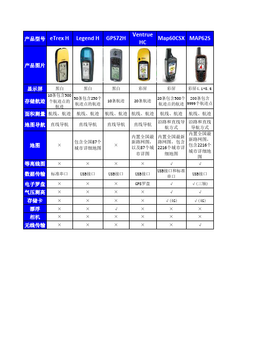
Legend H
GPS72H
Ventrue HC
Map60CSX
MAP62S
产品图片
显示屏
黑白
黑白
黑白
彩屏
彩屏
彩屏4.1*5.6
存储航迹
10条包含500 个航迹点的
航迹
50条包含250个 航迹点的航迹
10条航迹
20条航迹
20条包含500个 200条包含 航迹点的航迹 9999个航迹点
√(三轴) √(三轴) √(三轴)
√(三轴)
√
√
√
√
√(4G)
√(4G)
√(4G)
√(4G)
√
×
×
×
×
×
×
√(320万4倍变 焦)
√
√
√
√
导航方式 导航方式 导航方式
航方式
内置全国最 新路网图, 包含2216个 城市详细地
图
内置全国最 新路网图, 包含2216个 城市详细地
图
内置全国最 新路网图, 包含2216个 城市详细地
图
内置全国最新 路网图,包含 2216个城市详
细地图
√
√
√
√
USB接口和标 准串口
USB接口
USB接口
USB接口
细地图
内置全国最 新路网图, 包含2216个 城市详细地
图
×
√
√
数据传输 标准串口
USB接口
USB接口
USB接口
USB接口和标准 串口
USB接口
电子罗盘 ×
×
×
GPS罗盘
√
√(三轴)
气压测高 ×
同为旗舰GPS腕表佳明Garmin Fenix 5 Plus系列三款新品该如何选择?

同为旗舰GPS腕表佳明Garmin Fenix 5 Plus系列三款新品该如何选择?作者:来源:《汽车与运动》2018年第09期作为全球知名GPS腕表制造商,佳明(Garmin)最近明显加快了推出新品的频率。
近期,佳明一口气发布了Fenix 5 Plus 系列GPS运动腕表,包括Fenix 5S Plus、Fenix 5 Plus、Fenix 5X Plus三款产品。
作为旗舰GPS户外运动腕表新品,这三款机型均具备Garmin Pay电子支付及音乐离线播放功能,并具备16GB闪存(最多可存储500首歌曲),支持从iHeartRadio、Deezer等在线网站下载或电脑上直接拷贝获取歌曲等一系列新功能。
不过三款腕表的产品型号非常相似,大致的功能也很接近,但最大价格差达到了2000元左右(5S最便宜,5X最贵),那么它们的差异在哪里,我们选择哪款更合适呢?在腕表的尺寸和厚度方面,这三款机型就有一定的差异:其中Fenix 5S Plus表圈尺寸和厚度都最小,分别为42mm和15.4mm;而5X Plus最大,这两项数据分别为51mm和17.5mm。
不过它们的屏幕尺寸和分辨率都是完全相同的。
另外由于腕表机身体积不同,三者的表带尺寸也是不同的,同样是5S Plus最小,5X Plus最大。
此外5S Plus和5 Plus的表面采用了礦物玻璃和蓝宝石镜面两种不同的材质,其中后者价格更高;而5X Plus则均采用蓝宝石镜面,其在整体质感以及强光下的清晰度表现都会更为出色。
尽管在各种测量功能方面,三款腕表都非常齐全,不过Fenix 5X Plus还增加了对人体血氧浓度(Sp02)的监测。
血氧是人体机能正常运作的重要指标。
有了Fenix 5X Plus,你可以充分了解自己在户外运动以及睡眠状态时的血氧浓度数据,充分了解自己的身体状况,从而合理制定自己的运动计划。
除此之外,这三款腕表都能够支持日常活动数据监测、跑步骑行动态、VO2Max、导航、高度曲线、返回路线规划、ClimbPro爬升曲线等多种数据的测量,功能非常丰富。
手持GPS说明书

eTrex 操作手册目录一、介绍部分1.eTrex的超强功能…………………()2.eTrex 性能简介…………………………………()二、eTrex 的基本操作1.机体外部设计……………………………()2.基本按键操作……………………………三、功能画页简介1.卫星状况画页……………………………………()2.航及导航画页…………………………………………()3.罗盘导航画页…………………………………………()4.菜单画页…………………………………………()四、坐标系统的转换及校正……………………………() 1.坐标格式设置……………………………()2.坐标参数计算……………………………()3.参数输入……………………………()五、定位.导航功能设定………………………………………() 1.如何设定航点……………………………()2.如何编辑航线……………………………()3.如何导航……………………………()六、求面积操作……………………………………………()七、性能指标………………………………………………()八、选配件……………………………………………………()九、产品售后服务……………………………………………()十、装箱单…………………………………………1、eTrex的超强功能●真正并行12通道,可瞬间完成定位功能,在各种恶劣环境中尤显其卓越性能。
●全中文界面、人形图案、形象生动、妙趣横生。
●可自由转换坐标,包含WGS-84、BJ-54、西安-80及自定义坐标、各种球面、平面显示格式。
●可用来计算不规则地形的面积,方便快捷。
●内存大、存点多、航迹、航线多种导航方式。
●单手操作、简单易懂、使用更加便利、舒适●外形精巧、彩色封壳、鲜明活泼●只用两节电池、功耗低、重量轻、小巧精致、迷你设计。
●制作标记、外出更轻松,给出日出。
日落时间。
使你工作、计划井井有条。
2、eTrex 性能简介美国GARMIN公司一直投入大量的人力、物力,倾注于高水平GPS接收体制的研究。
Garmin GPS 产品说明书

Marking a waypoint is simply capturing your current location and storing it in the unit’s memory. The unit must be turned on and tracking satellites to mark a waypoint.To mark a waypoint:1. Press the Thumb Stick In and hold it until the Shortcuts Menu is displayed.2. Highlight Mark Waypoint and press the Thumb Stick In todisplay the Mark Waypoint Page shown below.Mark Waypoint PageName FieldSymbol Field3. Highlight the Name field and press the Thumb Stick In. Enter a new name. When finished, highlight OK then press the Thumb Stick In.4. Highlight the Symbol field and press the Thumb Stick In. Choose a symbol then press the Thumb Stick In to accept the selection.5. Highlight the OK button at the bottom of the page and press the Thumb Stick In to save the waypoint.As you move, notice that a breadcrumb trail of your path is left on the map. This trail is called a Track Log. You can use the track log to retrace your steps back to a certain location.To view your breadcrumb trail (track log):1. Use the Page button to display the Map Page.2. Walk away from your original location for at least three minutes.3. The default zoom level is 80 miles. Press the Zoom button to zoom in to view the breadcrumb trail (track log) in detail.You can send any location that you have available in your Find ‘N Go menu. These may be waypoints, contacts, cities, exits, or any other data that is loaded in the unit. Below are the steps to send a waypoint.To send a location (waypoint) using Find ‘N Go:1. Press the Thumb Stick In and hold it until the Shortcuts Menu is displayed, or press the Page button until the Main Menu is displayed.2. Highlight Find ‘N Go and press the Thumb Stick In. Highlight Way-points and press the Thumb Stick In. Select Nearest or By Name andpress the Thumb Stick In.3. Highlight the waypoint that you want to send and press the Thumb Stick In to display the Waypoint Review page.4. Highlight the Option Menu button and press the Thumb Stick In.5. Select Send Location and press the Thumb Stick In.The location is sent to all Rinos on the same channel and squelch code as you. They can then choose to Goto that location, view the location on the map (Map ), or save the location (OK ).The Rino’s most unique feature is Peer-to-Peer positioning, send-ing the location of one Rino unit to other Rino units. Peer-to-Peer positioning allows you to track the movement of other Rino users and even navigate to their location. To send your location:Press and release either the Call or Talk button. Your Rino 110 automatically sends out its location. Other Rino users monitoring the same channel and squelch code receive this information.Using Find ‘N Go, you can search for a waypoint and then create a straight-line route to it from your current location.To find and go to a waypoint:1. Press and hold the Thumb Stick In to access the Shortcuts Menu.2. Highlight Find ‘N Go and press In.3. Highlight Waypoints and press the Thumb Stick In. Select Nearest from the pop-up menu4. Use the Thumb Stick to select the desired waypoint from the list and then press In to display the Information Page for that waypoint.5. Highlight Goto and press In to create a straight-line route to the waypoint from your current location.If you have not heard from a contact in a while and would like to know that contact’s current location, you may “poll” the contact’s location. This will update that contact’s location in your Rino 110.To poll a location:1. Press the Thumb Stick In and hold it until the Shortcuts Menu is displayed, or press the Page button until the Main Menu is displayed.2. Highlight Find ‘N Go and press the Thumb Stick In. HighlightContacts and press the Thumb Stick In.3. Highlight the contact that you want to poll and press the Thumb Stick In to display the Contact Review page.4. Highlight the Option Menu button and press the Thumb Stick In.5. Select Poll Location and press the Thumb Stick In.If you have further questions or just want to learn more about the operation of Rino 110, refer to the Owner’s Manual , which provides detailed information about all of your Rino 110’s features.Quick Start Guide110Step-by-Step Instructions(Turn this page and begin with Step 1)Part Number 190-00251-01 Rev. CYou can navigate to a waypoint, city, exit, or a contact’s location. Using optional detailed maps, you can also navigate to points of interest, addresses, and intersections.To begin navigation using Find ‘N Go:1. Press the Thumb Stick In to display the Shortcuts Menu.2. Highlight Find ‘N Go and press the Thumb Stick In.3. Highlight Waypoints and press the Thumb Stick In. Select the desired option (by Nearest or by Name ), and press the Thumb Stick In.4. Highlight the desired waypoint and press the Thumb Stick In.5. With the Waypoint Page displayed, highlight the Goto button at the bottom of the page and press the Thumb Stick In to begin navigation. The Navigation Page automatically opens to guide you to your destination. See below for more information.Navigation PageThe two main components of the Navigation Page are the compass ring and the pointer. As you move, the compass ring rotates showing your current direction of travel at the top of the display. The pointer points toward your destination. When the pointer is aligned withthe vertical line at the top of the compass ring, you are on a direct course toward your destina-tion. The unit has to be moving to navigate. If you are standing still or moving very slowly, the navigation data may not be accurate.The first time you receive a signal from another Rino user, the New Contact page is displayed. From the New Contact page you can show the user’s location on your Map, Goto that position, select OKto add them to your contact list, or press the Page/Quit button to disregard the contact.Every time you receive signals fromcontacts, your map is updated showing their new position. A Track Log of their move-ment is created and shown on your map.Navigation Page New Contact PagePolling a contact’s locationPower button:• Press and hold to turn the unit On/Off• Press to adjust contrast and backlightingCall button:• Press to send out Call Tone • Sends position when released (if enabled)Talk button:• Press and hold to talk • Sends position when released (if enabled)Page/Quit button:• Press to cycle through main pages• Used to quit or escape menu itemsVolume (V) button:• Press to open volume control windowMicrophone:• Hold unit 3–4 inches away when talkingZoom/Map (Z) button:• From the Map Page, press to open Zoom control window • From any other page, press to display Map PageSpeakerThumb Stick• Press In to enter highlighted options and to confirm messages• Move Up, Down, Right or Left to move through lists, highlight fields, on-screen buttons, icons, enter data, or move the map panning arrow • Press In and hold to display Shortcuts Menu.Send Location1The Rino 110 operates on three “AA” Alkaline batteries (not included) located in the back of the unit. Rechargeable batteries may also be used. The unit is factory set to use Alkaline batteries. See the Rino 110 Owner’s Manual for setting battery type. Stored data is not lost when the batteries are removed.To install batteries:1. Remove the battery cover on the back of the unit. Turn theD-ring 1/4 turn counter-clockwise and pull the cover off.2. Insert batteries observing the polarity reference molded intothe unit housing. Orient the negative (-) battery terminaltoward the spring.3. Reinstall the battery cover by inserting the bottom hinge clipand closing the cover. Turn the D-ring 1/4 turn clockwise.Notes on battery use:• When replacing batteries, use only new or fully recharged batteries. Rechargeable batteries may typically display lesscapacity than Alkaline batteries.• Do not mix different types of batteries together.• Remove the batteries from the unit if you do not plan to use it for several months. Follow the battery manufacturer’s instruc-tions for proper care and disposal of used batteries.• Extensive use of backlighting, WAAS, and/or FRS or GMRS will significantly reduce battery life.2All of the information you need to operate the Rino 110 can befound on five default main pages (or display screens). Simply pressand release the Page key to cycle through the Radio Page, MapPage, Navigation Page, Trip Computer, and Main Menu Page. Youcan also access the Main Pages by pressing the on-screen Main PageMenu button .Trip ComputerMain Menu Navigation PageWhile these five Main Pages provide you with different types ofinformation, they all share common features like Option Menus anda Main Page Menu. Access the Option Menu and Main Page Menuby using the Thumb Stick to highlight the on-screen button. Thenpress the Thumb Stick In.3Before the Rino 110 can be used for navigation, the GPS receivermust be initialized. Initialization allows the Rino 110 to receiveand store satellite information and begin using the satellites fornavigation. The initialization is automatic and should only take afew minutes.To initialize the unit (acquire satellites):1. Take the Rino 110 outside where it has an unobstructed viewof the sky and turn it on.2. The unit begins to search forsatellite signals. “Tracking Satel-lites” is displayed while the unit isinitializing.The first time you use your Rino110, initialization should take nomore than five minutes.3. When the GPS is initialized and ready for navigation, themessage “3D Accuracy” is displayed on the Radio Page.If for some reason the unit is not able to gather the necessary satel-lite information, refer to the Rino 110 Owner’s Manual.4 Entering DataUse the Thumb Stick like a joystick that youcontrol with your thumb. Move the ThumbStick Up, Down, Right, or Left. Press theThumb Stick In to select an item on thescreen, much like pressing the Enter buttonon a computer keyboard.Sometimes you will need to spell out things using the Thumb Stickand an on-screen keyboard. To enter characters with the on-screenkeyboard, press the Thumb Stick Up, Down, Left, or Right tohighlight the desired character (letter, number, or a space). Press theThumb Stick In to select that highlighted character. Choose Backto delete the character to theleft of the cursor. When youare finished entering charac-ters, highlight OK and pressthe Thumb Stick In.5Select a channel and squelch code to transmit on. Be sure to tell theother members of your group what channel and squelch code youare using so they can communicate with you.To select a channel:1. Highlight the Channel field and pressthe Thumb Stick In.2. Select an available channel andpress the Thumb Stick In to acceptthe selection.To select a squelch code:1. Select the Code field and press theThumb Stick In.2. Select one of the thirty-eight (38)available codes. Press the ThumbStick In to accept the selection.6The My ID (name) and symbol (icon) identify you to otherRino users.To change the unit ID/name:1. Highlight the My ID field and pressthe Thumb Stick In to activate thefield and display the keyboard.2. Highlight Clear, then press theThumb Stick In to clear thedefault ID.3. Enter an ID, or name, up to ten(10) characters long.4. When you have entered your newID, highlight OK and then pressthe Thumb Stick In.To change the user symbol:1. Highlight the face symbol to the right of the My ID field. Pressthe Thumb Stick In to show a list of available face symbols.2. Highlight the desired symbol from the list of selections.3. Press the Thumb Stick In to select that symbol.7The Rino 110 can transmit to and receive messages from other FRSradio users on the same channel and squelch code. To use all of thefeatures of the Rino, communicate with other Rino units.To transmit on your Rino 110:1. Press and hold the Talk button and speak in a normal voiceinto the microphone area on the front of the Rino 110 from adistance of about 3–4 inches.2. When you are finished talking, release the Talk button. Yourlocation is updated on all receiving Rinos.3. If you want to call another user or update your location onanother Rino, press and release the Call or Talk button.8If you need to adjust the volume, press the V (Volume) button onthe front of the unit to display an adjustment slider. To change thevolume, press the Thumb Stick Up or Down to raise or lower theslider. When you have the proper level set, press the V button orpress the Thumb Stick In.If lighting conditions make it hard for you to see the display screen,you can adjust the contrast or turn on the backlight.To turn on the backlight and adjust the screencontrast:1. With the unit on, briefly press and release the Power buttonto display the Backlight and Contrast adjustment.2. Press thePower button or press Up or Down on the ThumbStick to turn the Backlight on or off. A light bulb symbol ap-pears on the top Status Bar when the backlight is on.The backlight remains on until the set timeout period iscompleted or the Power button is pressed again. The unit isfactory set to timeout 15 seconds after the last button press.3. Move the Thumb Stick to Left (Lighter) or Right (Darker) toadjust the contrast.4. Press the Thumb Stick In to close the Backlight and Contrastwindow.Example of an on-screen keyboardTracking Satellite SignalsSelecting the channelMy ID field Symbol fieldMain Page Menu buttonOption Menu button。
Garmin GPS手持导航仪地图功能的应用

0 引 言
Gami G S手持 导航 仪 是 目前 世 界 上 最 为 流 r n P 行 的手持 导航 定位 仪 器 , 因其 具有 轻便 灵 活 、 功能 强
大 等特 点 , 受广 大用 户 的欢迎 。G r n手 持 导航 深 ami 仪 应用 于 石 油物探 生产 之后 , 大 提 高 了野 外 采集 大
关 键 词 G r n手持 导 航 仪 地 图 功 能 地 震 勘 探 a mi
ABSo hem a un to fGa m i ha hed GPS n v g t r EGP, 01 21( o lc to ft p f c i n o r n nd l a iao . 2 1, 4):2 64~ 2 67 G a m i a r n H ndh l vi t r i u r ty t l stwi l e n — l avga i v c e d Na ga o s c r en l he n o de y us d ha d— d n i ton de i e whih p a e n i — he c l y d a m — p t ntr e i na i ton n po iini ora ol n vga i a d sto ng ope a i n or es i ur y Thi pa r a l z s he m a f r to f s im c s ve . s pe na y e t p unc in f to o
集 作 业 中必 不可 少 的辅 助定位 工 具 。 随着 信 息技术 的进步 与发 展 , D扩展 卡渐 渐应 S 用 到 手持 导航 仪 中 , 容 量 从 最 初 的 6 MB扩 展 到 卡 4 现在 的 2 GB, 人 们 可 以 随 心 所 欲 地 存 储 Ma — 使 p
佳明runner55说明书

佳明runner55说明书摘要:一、前言二、产品概述三、功能特点四、操作与设置五、跑步模式与训练六、心率监测与运动数据七、充电与续航八、适用场景与人群九、产品规格与配件十、售后服务与注意事项正文:【前言】佳明runner 55是一款专为跑步爱好者设计的运动手表,集运动、健康、智能等功能于一身,帮助用户更好地享受跑步的乐趣。
【产品概述】佳明runner 55采用了一块高分辨率的彩色屏幕,可以清晰地显示运动数据。
手表采用轻量化设计,佩戴舒适。
支持多种运动模式,包括跑步、骑行、游泳等。
此外,还具备心率监测、GPS定位、音乐播放等功能。
【功能特点】1.高清彩屏:佳明runner 55采用了一块高分辨率的彩色屏幕,可以清晰地显示运动数据,让用户随时了解运动状态。
2.多运动模式:支持多种运动模式,包括跑步、骑行、游泳等,满足用户多样化的运动需求。
3.GPS定位:内置高精度GPS模块,实时记录运动轨迹,帮助用户更好地规划运动路线。
4.心率监测:采用光电心率传感器,实时监测心率,为用户提供更加准确的运动数据。
5.音乐播放:支持音乐播放功能,用户可以在运动过程中听音乐,增加运动乐趣。
6.智能提醒:支持来电、短信、社交媒体等智能提醒,方便用户在运动过程中随时查看重要信息。
7.久坐提醒:定时提醒用户活动一下,预防久坐带来的健康问题。
【操作与设置】佳明runner 55操作简便,用户可以根据手表上的按键进行基本操作。
同时,通过与手机连接,用户可以在手机上安装的佳明运动APP中进行详细设置,包括运动目标、训练计划等。
【跑步模式与训练】佳明runner 55具备专业的跑步模式,可以根据用户的需求设置跑步目标、训练计划等。
手表还会根据用户的运动数据,提供科学的运动建议,帮助用户提高运动效果。
【心率监测与运动数据】佳明runner 55采用光电心率传感器,实时监测心率,为用户提供更加准确的运动数据。
同时,手表还会记录运动轨迹、速度、距离、卡路里等信息,方便用户了解运动情况。
佳明表盘详解
Select Graph type
选择图形类型
(activity monitor活动监视器、heart rate心率temperature温度pressure压力elevation海拔)
garmin佳明本能Instinct2X(佳明本能2X)怎么样,有哪些优点
garmin佳明本能Instinct2X (佳明本能2X)怎么样,有哪些
优点
佳明本能Instinct Solar 2X有两个版本可选,分别是佳明本能Instinct2X太阳能运动版和佳明本能Instinct2X太阳能战术版,这两个版的区别是后者多了专业战术功能,包括隐蔽模式和跳伞大师(可空中引导导航)。
佳明本能Instinct 2X外观颜色有石墨灰、暗夜黑、雪峰白、苍山绿、烈焰红五种可选,然后整体采用led手电筒设计,支持led照明功能,并有白、红两种光源,可自定义多种闪频方式。
然后它的机身尺寸是50*50*14.5mm,重67g。
以及搭载的是一款1.1英寸屏幕。
佳明本能Instinct 2X还有以下配置:
1.支持多频多星定位,可以提高定位精度,加快定位速度。
2.有145小时gps模式续航、36小时多频多星定位续航、智能模式无限续航。
3.配有abc传感器,可知道当前气压、海拔、方位等信息,并配有日出日落时间。
4.支持消息通知、久坐提醒、压和追踪、nfc交通卡、离线支付等功能,
5.配有全天监测,包括早安问候、全天心率、hrv状态、睡眠、身体电量、血氧检测。
6.配有50+运行模式,包括hiit、有氧运动、力量训练、徒步、滑雪、冲浪等
7.配有garmin connect 健康和健身数据管理平台。
- 1、下载文档前请自行甄别文档内容的完整性,平台不提供额外的编辑、内容补充、找答案等附加服务。
- 2、"仅部分预览"的文档,不可在线预览部分如存在完整性等问题,可反馈申请退款(可完整预览的文档不适用该条件!)。
- 3、如文档侵犯您的权益,请联系客服反馈,我们会尽快为您处理(人工客服工作时间:9:00-18:30)。
品牌型号产品特点
etrex 10双星小博士2012年新款,半反半透黑白液晶屏幕,高灵敏度芯片,双星系统(GPS+GLONASS)超过48颗卫星服务,可以快速定位,快速精准面积测量,USB接口,支持全国背景图,中途暂停及关机后再开机仍可连续累计测量功能;
eTrex 202012年新款,彩色屏幕,高灵敏度芯片,双星系统(GPS+GLONASS)超过48颗卫星服务,可以快速定位,快速精准面积测量,内存2G,支持SD卡扩展,USB接口,2000个航点,10000个航迹,200条航线,支持全国详细地图(选配),中途暂停及关机后再开机仍可连续累计测量功能;
eTrex 302012年新款,彩色屏幕,高灵敏度芯片,双星系统(GPS+GLONASS)超过48颗卫星服务,可以快速定位,快速精准面积测量,内存4G,支持SD卡扩展,USB接口,2000个航点,10000个航迹,200条航线,支持全国详细地图,气压测高仪,三轴电子罗盘,中途暂停及关机后再开机仍可连续累计测量功能;
GPS 72H 2012年新款,高感芯片,近3寸屏幕(大),字体大,可漂浮,USB 接口,3000个航点,50条航线,9条航迹。
map62s 2012年新款,高感芯片,60CSX升级版,4G内存,2012年新版电子地图(全国2200个城市以上),气压测高仪,三轴电子罗盘,USB接口。
无线传输功能,Google地球数据导出。
map78s 2012年新款,高感芯片,60CSX升级版,4G内存,2012年新版电子地图(全国2200个城市以上),气压测高仪,三轴电子罗盘,可漂浮设计.无线传输功能,Google地球数据导出。
map 62sc 2012年新款,高感芯片,500万像素摄像头,4G内存,预装中国大陆导航电子地图,气压测高仪,三轴电子罗盘,坐标系统与格式转换功能;USB接口;无线传输功能,Google地球数据导出。
Dakota 20达
科塔2012年新款,高感芯片,近3寸屏幕,触摸屏,简体中文手写,2012年新版电子地图(全国2200个城市以上),1G内存,三轴电子罗盘,气压测高仪,USB接口,支持SD卡扩展。
配4G地图卡。
Oregon450俄
勒冈2012年新款,高感芯片,近3寸屏幕,触摸屏,简体中文手写,2012年新版电子地图(全国2200个城市以上),4G内存,三轴电子罗盘,气压测高仪,USB接口,支持SD卡扩展。
无线传输功能,Google 地球数据导出。
Oregon550俄
勒冈
比450多个320万摄像头。
Rino 520HCX 彩屏,高感芯片,USB接口,外接天线,2012年新版电子地图(全国2200个城市以上),锂电池,可导航,防水,通讯加密,有对讲功能,实时发送当前坐标,在密林、峡谷、楼宇中均能快速定位。
Rino 530HCX同上,比520HCX多个电子罗盘,气压测高仪。
eTrex H 小
博士2012年加强版,高感芯片,四级灰度屏幕,串口接口,1000个航点,20条航线,20条航迹,9999个航迹点,串口数据线(选配)。
VentureHC 彩屏小博士高感芯片,彩色屏幕,全国背景底图,USB接口,1000个航点,500条航线,20条航迹。
佳明手持GPS 产品特点表
Map60CSX 炫
彩高感芯片,彩色屏幕,人体工学设计,外接天线接口,2012年新版电子地图(全国2200个城市以上),气压测高仪,地磁罗盘,串口与USB接口,支持MicroSD卡扩展,1000个航点,50条航线,20条航迹,可无限存储航迹,标配4G卡。
Legend H 传
奇高感芯片,四级灰度屏幕,全国简单背景图,USB接口,1000个航点,50条航线,20条航迹。
Vista H 展
望高感芯片,四级灰度屏幕,全国简单背景图,气压测高仪,地磁罗盘,USB接口,1000个航点,50条航线,20条航迹。
Vista HCX 峰
彩高感芯片,彩色屏幕,全国2200个城市导航地图,气压测高仪,地磁罗盘,USB接口,支持MicroSD卡扩展,1000个航点,50条航线,20条航迹,可无限存储航迹。
GPS 60四螺旋天线,人体工学设计,28小时使用时间,串口与USB接口,外接天线接口,2万个城镇,500个航点,50条航线,20条航迹,外接车载天线。
GPS 72四螺旋天线,近3寸屏幕(大),字体大,可漂浮,串口接口,2998个航点,50条航线,9条航迹。
停产产品。
