最新版Petrel地质建模手册1
Petrel中文操作手册
Petrel软件实例操作流程目录第一章Petrel简介1.1安装并启动Petrel (01)1.2界面介绍 (02)1.3常用术语 (10)第二章Petrel处理流程介绍2.1数据准备 (15)2.2断层建模 (20)2.3 Pillar 网格化 (30)2.4创建层面网格 (35)2.5时深转换 (40)2.6细分地层 (42)2.7建立几何模型 (43)2.8离散化测井曲线 (44)2.9数据分析 (45)2.10相建模 (50)2.11属性建模 (62)2.12体积计算 (71)2.13绘图 (75)2.14井轨迹设计 (77)2.15油藏数值模拟的数据输入和输出 (80)第一章Petrel简介1.1安装并启动Petrel把安装盘放入光驱,运行Setup.exe程序,根据提示就可以顺利完成安装,在安装的过程中同时安装DONGLE的驱动程序,安装的过程中不要把DONGLE插入USB插槽,安装完毕,再插入DONGLE,如果LICENSE过期,请和我们技术支持联系,然后按下面的顺序打开软件。
1. 双击桌面上的Petrel图标启动Petrel。
2. 如果是第一次运行Petrel,将出现一个Petrel的介绍窗口。
3. 打开Gullfaks_Demo项目。
点击文件>打开项目,从项目目录中选择Gullfaks_2002SE.pet。
1.2界面介绍1.2.1菜单/ 工具栏与大多数PC软件一样,Petrel软件的菜单有标准的“文件”、“编辑”、“视图”、“插入”、“项目”、“窗口”、“帮助”等下拉菜单,以及一些用于打开、保存project的标准操作按钮。
在Petrel的显示窗口的右边是对应于操作进程的工具栏,这些工具是否有效取决于选择进程表中的哪个进程。
操作步骤1.点击上面工具栏中的每一项看会出现什么,你可以实践一些感兴趣的选项。
2.将鼠标放在工具栏中的按钮上慢慢移动,将会出现描述每一个按钮功能的文本出现。
petrel RE详细培训资料
纵向上zone分区-基于储量 可以选择怎么分
分区-基于PVT、相渗 计算同上,
纵向上zone分区-基于储量
纵向分区-基于PVT、相渗
平面分区-基于PVT、相渗
多边形多个分区
例如做3个分区
名字要唯一
怎么设置显示井的方式(井很长,显示不一样)
怎么设置显示井的方式(井很长,显示不一样)
打开文件夹,找到主文件 (data)
去文件目录下找到这个文件, 并进行修改
就是这个 文件
编写椭圆里的信息,可调用这个文件,并 且要把mult这个文件拷到主文件夹下。
以上做完之后,可重新define一个case, 然后运行模拟,去比较结果。
三、如何修改断层传导系数
可以对每个断层的传导系数进行修改,0.5 是半封闭,1是不封闭,0是完全封闭
2、导入EV文件
匹配好井名
2、导入EV文件
对时间的设置一 定要改成一致
2、导入EV文件
上下都要勾上才 能显示
3、自动方式设计完井
里导入射孔文件
这个时间是创建井的时间
套管
创建一个简 单完井事件
五、如何导入井的历史数据
五、如何导入井的历史数据
五、如何导入井的历史数据 名字要匹配
五、如何导入井的历史数据
网格的趋势线方向 ,一般参考主断层 的方向
第一步:平面网格的粗化
粗化到的模型,现 在只有平面的网格
第二步:纵向网格的粗化
输出的粗化模型 原始模型
可以把zone减少,比方说3个搞成 2个,但是注意zone1的底深和 zone2的顶深要一致
第二步:纵向网格的粗化
layering也可以粗化
第二步:纵向网格的粗化
一、粗化地质模型(respect,grid,edit); 二、高压物性、相渗(props); 三、初始化(solution); 四、分区(regions); 五、输出控制(summary); 六、观测数据(schedule)。
Petrel地震地质解释和建模使用技巧
Petrel地震地质解释和建模使用技巧Petrel 合成记录工作流制作合成地震记录,进行层位标定和确定时深关系是地震解释工作中非常重要的环节。
从Petel2009.1.1,开始Petrel里有两个制作合成记录的模块,一个叫Synthetics,一个叫Seismic-Well tie。
这里介绍如何使用Synthetics模块制作合成地震记录。
从Petrel 2007开始Synthetics模块有了很大改进。
最重要的变化是其结果可在Global well logs下有相应的synthetic目录,其相应时深关系可在数据表中显示。
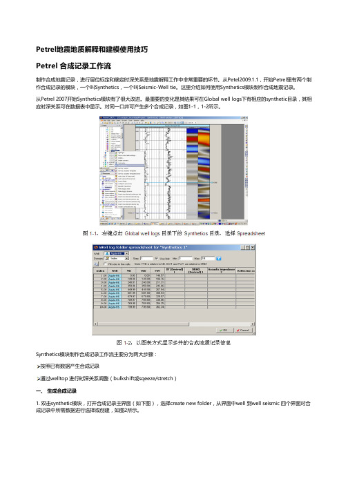
对同一口井可产生多个合成记录,如图1-1,1-2所示。
Synthetics模块制作合成记录工作流主要分为两大步骤:按照已有数据产生合成记录通过welltop 进行时深关系调整(bulkshift或sqeeze/stretch)一、 生成合成记录1. 双击synthetic模块,打开合成记录主界面(如下图),选择create new folder,从界面中well 到well seismic 四个界面对合成记录中所需数据进行选择或创建,如图2所示。
Well:选择要做合成记录的井,可多选,但每口井必须有相应的数据(DT和子波)。
Sonic and time:确定原始输入数据及时深关系。
根据实际数据品质,如果有checkshot,可用来做DT曲线校正;所有井上时深关系以工区井目录,以及每口井的Settings界面里Time界面下设置为准,Synthetics界面里的Overwrite global time log项不启用。
Create synthetic seismogram:创建合成记录选择创建合成记录所需数据:Density、Acoustic Impedence、Reflectiotion coefficients和Wavelet。
如果这些数据都不存在,或者希望修改参数重新创建,则点击黄色星状按钮创建新数据。
Petrel储层地质建模
Petrel储层地质建模软件Petrel为多学科一体化工作提供了研究平台,适用于各种油藏类型。
利用多资料的综合分析与研究,Petrel可以精确描述油气藏及其孔渗饱等属性参数的空间分布,计算其储量、定量估算风险性、从而降低开发成本,提高效益。
Petrel 由以下六个软件包组成,在核心系统的支持下,各系统可以独立或协同工作。
Petrel以更快、更精确、更为经济的技术手段满足了精细地质研究对软件的需求。
◇地震资料解释系统(Petrel Geophysics)◇地质综合分析系统(Petrel GeoScience)◇地质建模系统(Petrel Modeling)◇油藏工程系统(Petrel Reservoir Engineering)◇实时决策系统(Petrel Realtime)◇数据与成果浏览系统(Petrel Viewer)集成化数据管理平台确保了各主流公司软件的兼容问题。
包括:Landmark、Geoframe、Eclipse、VIP、Earthvision、RMS等标准数据格式。
实现对数据的集中储存、管理与共享,统一勘探、开发数据,数据的标准化程度得到极大提高。
地震资料解释系统(Petrel Geophysics)提供完整的微机地震资料综合解释解决方案。
可快速实现常规地震资料剖面解释和三维立体解释、提取地震属性、瞬层属性平面成图、进行速度分析及域转换,利用蚂蚁追踪模块可以实现断层自动解释及提取,并可直接转换到模型中建立构造框架。
全方为满足科研与生产所需的各种功能,通过地震数据网格重采样建立地震实体模型,预测有利目标。
◇合成记录及层位标定◇地震数据叠后处理◇自动构造解释◇地震储层反演◇层位及断层追踪解释◇地质体雕刻◇速度分析及域转换◇地震重采样◇储层预测及目标优选地质综合分析系统(petrel GeoScience)Petrel为用户提供完整的地质基础研究一体化解决方案。
可以进行测井解释、沉积微相划分、地层对比、储层四性关系研究等工作。
petrel操作手册
petrel操作手册本文将会介绍Petrel操作手册,并提供相应的操作步骤。
Petrel是一款用于地质模型建立、分析和可视化的软件。
下面将详细介绍如何使用Petrel完成地质模型建立。
第一步、创建项目在Petrel中打开新项目时,可以创建一个新的空白项目或导入已有项目。
在开始新项目时,需要输入项目名称和项目描述,并选择一个项目目录或创建一个新的目录。
此外,还可以选择一个默认的数据仓库和一个默认的工作区。
第二步、导入数据Petrel支持多种格式的数据导入。
在导入之前,需要确保数据格式正确并具有必要的元数据。
在导入数据之前,可以先定义数据类型、数据格式和属性等元数据信息,并设置坐标系和地震属性。
然后,可以使用Petrel的导入向导将数据导入到项目中。
第三步、创建地质模型Petrel提供了各种工具和算法来创建地质模型。
在开始之前,需要确定地质模型的范围、地球物理属性和地震数据。
可以使用Petrel的网格化工具创建网格,并使用地球物理数据来定义地质单元。
使用“构建模型”工具可以创建模型,并在模型中添加地球物理数据和地震数据。
第四步、分析和可视化Petrel提供了许多分析和可视化工具来优化和理解地质模型。
可以使用调色板和过滤器来可视化地球物理属性和地震数据,使用剖面工具和交互式工具来分析模型的三维分布和二维分布。
还可以使用Petrel 内置工具进行模拟,模拟过程包括模型搭建、模拟参数设定、模拟演示等。
总之,Petrel操作手册提供了许多工具和算法来创建、分析和可视化地质模型。
上述步骤仅是基本操作,读者可以根据自己的需要和实际情况进一步学习和使用。
Petrel是一个非常强大的工具,具有广泛的适用性和丰富的功能,旨在帮助地质学家、地球物理学家和油田工程师等地球科学从业人员完成各种任务。
可能是最简单的Petrel建模流程
可能是最简单的Petrel建模流程Petrel是一种用于油气勘探和生产建模的地质学和工程学软件,可以帮助地质学家和工程师进行不同类型输入数据的解释和模拟。
本文将介绍Petrel的最简单建模流程,并逐步讲解其主要步骤。
步骤1:启动Petrel软件并创建一个新的工程首先,您需要启动Petrel软件。
打开软件后,您将看到一个“新建工程”对话框。
在这个对话框中,您可以为新的工程选择一个名称并定义其相应的路径。
然后,单击“创建”按钮以创建新的工程。
步骤2:导入数据一旦新的工程创建完成,您将看到Petrel的主界面。
在主界面的左侧面板中,选择“数据导入管理器(Data Import Manager)”按钮。
然后,在数据导入管理器对话框中,选择“添加”按钮,以导入地质数据。
步骤3:解释地质数据在步骤2中,您可以导入各种类型的地质数据,例如测井数据、地震数据和地质模型数据。
当数据导入完成后,您需要对这些数据进行解释。
例如,您可以使用测井数据对地层进行解释,并使用地震数据进行结构解释。
通过解释地质数据,您可以获得有关地下结构和储层特性的更多信息。
步骤4:创建地质模型在步骤3中,您可以将解释好的地质数据用于创建地质模型。
在Petrel中,您可以通过多种方式创建地质模型,包括地层划分、网格建模和地质建模等。
这些方法允许您将地质数据应用于地质建模,以获得更准确的地质模型。
步骤5:导入生产数据在创建了地质模型之后,您可以导入生产数据,以评估油田或气田的生产潜力。
在Petrel的左侧面板中,选择“数据导入管理器(Data Import Manager)”按钮,并选择“添加”按钮,以导入生产数据。
然后,使用这些生产数据对地质模型进行评估,以确定最佳的开发方案。
步骤6:评估生产方案在步骤5中,您导入了生产数据并将其应用到地质模型中。
您可以使用这些数据来评估不同的生产方案,并找到最佳的开发策略。
例如,您可以尝试不同的注水井和采油井配置,并使用模型进行模拟以评估不同方案的效果。
PETREL操作手册文字版
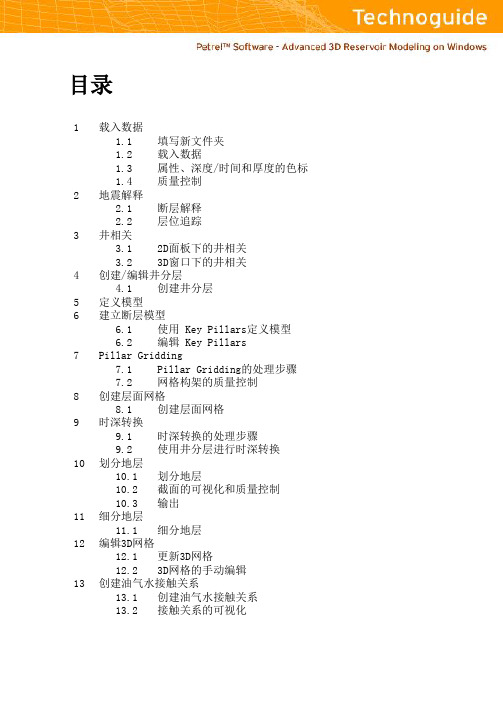
填写新文件夹 载入文件 色标模板充填 截面显示开关
1.1 填写新文件夹
在把数据载入PETREL之前, 必须建立文件夹来存放不同类型的输入数据.在载入数据 时, 会弹出一个用来定义文件格式“Input File dialog” 的对话框, 数据应该依照不同的 类型放入不同的文件夹.
PETREL 支持多种格式用于数据的载入和输出 (参见表3, Getting Started Manual).
备注:
设置色标的另外一种方法是打开某一 等值面,等容线和属性的设置窗口(双击 PETREL资源管理器中的对象名称)设 定颜色刻度和最大、最小值.
1.4 质量控制
输入数据的质量控制对于模型的建立非常重要. 在显示窗口显示输入数据(放大,旋转, 全景),检查数据的不一致性. 使用截面模式是检查相交层面和其他不一致性的有力工 具. 显示检查以后打开settings 对话框检查输入数据的统计资料.
解释层位:
1. 插入Inline Intersection并显示地震 数据( 蓝色的按钮) .
2. 单击Seismic Interpretation处理步骤 使之处于活动状态.
3. 单击功能栏中的Interpret Horizon 按 钮 (或使用快捷键 H).
4. 然后单击功能栏中的 Guided autotracking 按钮.
- 观察3D下的变化.
10. 改变地震剖面的settings 窗口中颜 色 (在 colors 标签中). 移动颜色设置中 的不透明曲线,观察变化.
备注:
3D下对地震解释的结果进行质量控制 的最佳方法是使用地震面播放器显 示数据体的内部信息.
3. 井相关
PETREL可以在屏幕上进行快速相关操作. 在井剖面可以进行多井显示,层位拾取,基 准面校正,加入新井和相关过的井进行比较.
Petrel中文操作手册
Petrel软件实例操作流程目录第一章Petrel简介1。
1安装并启动Petrel……………………………….。
.01 1。
2界面介绍…………………………………………。
..02 1。
3常用术语…………………………………………。
.。
10第二章Petrel处理流程介绍2.1数据准备.............................................。
(15)2.2断层建模.............................................。
(20)2。
3 Pillar 网格化………………………………….…。
302.4创建层面网格……………………………………。
352.5时深转换………………………………………….。
402。
6细分地层 (42)2.7建立几何模型………………………………….…。
432.8离散化测井曲线…………………………………。
442。
9数据分析 (45)2.10相建模…………………………………….。
……。
.502。
11属性建模……………………………………….。
62 2。
12体积计算……………………………………。
.….。
712。
13绘图………………………………………….。
…。
.75 2。
14井轨迹设计…………………………………。
….。
772.15油藏数值模拟的数据输入和输出………。
.……。
80第一章Petrel简介1.1安装并启动Petrel把安装盘放入光驱,运行Setup.exe程序,根据提示就可以顺利完成安装,在安装的过程中同时安装DONGLE的驱动程序,安装的过程中不要把DONGLE插入USB插槽,安装完毕,再插入DONGLE,如果LICENSE过期,请和我们技术支持联系,然后按下面的顺序打开软件.1. 双击桌面上的Petrel图标启动Petrel。
2. 如果是第一次运行Petrel,将出现一个Petrel的介绍窗口。
3。
打开Gullfaks_Demo项目.点击文件〉打开项目,从项目目录中选择Gullfaks_2002SE.pet。
Petrel_简易操作手册
P ETREL TM简易操作手册北京阿什卡科技开发有限公司Petrel简易操作手册Petrel Workflow Tools Tutorial Copyright © 2005 Schlumberger & ESSCA, 版权所有. 历史V 0.0.2基于 Petrel 2004,中文版V 0.0.1基于 Petrel 2003SE,英文版目录建模基本流程图 1 第一章界面介绍 5 第二章数据输入7 第三章数据整理22 第四章构造模型30 第五章属性模型41 第六章粗化模型51 第七章辅助功能57第一章界面介绍Petrel是一个基于Windows平台,用于三维显示、三维成图和三维油藏建模的软件。
用户界面在按钮、对话框和帮助系统方面都是基于Microsoft Windows标准。
这使得Petrel对于当今的大多数地质学家非常容易上手,同时保证高效的程序使用。
练习1-1 启动Petrel双击桌面上的Petrel图标启动Petrel。
或者,选择 > Programs > Petre2004 > lPe2004trelPetrel 用户界面Title bar (标题栏)- 文件名(工区名)和所在路径显示于标题栏。
通过按住和托拽标题栏来在桌面上移动Petrel窗口。
Menu bar (菜单栏)– (顶部)点击菜单栏上任何一个标题都展开一个对话框、弹出菜单、命令和特征的列表。
Toolbar (工具栏)- (顶部)常用命令工具。
这些工具是非常有用的项目的链接,用户也可以在菜单栏里面找到。
Function bar (功能栏)- (右侧)流程特定功能。
这些工具会因为选择了不同的流程单元而改变。
注意一共有两个功能栏,一个在右手边,一个实在显示窗口的下边。
Petrel Explorer (Petrel浏览器)– (左侧)用于优化各种模型关联数据的文件管理起。
包括四个栏目,Input(输入,输入数据管理)、Models(模型,创建的模型)、Results(结果,一些例如体积计算等的结果)和Templates(模版,用于显示数据的颜色、标尺等)。
Petrel三维地质建模

C B 2 5 D -4 C B 2 5 1 B -4
C B 2 2 A -2 CB11E-6 CB11E-5
CB22 C B 22 C -1
C B 1 1 E -4
C B 2 2 C -6
CB11G-4 CB11E-1 C B 1 1 D -6
CB22C-3 CB253
CB11E-3 CB11D-5
C B 2 5 C - 5 C B 2 5 C - 4C B 2 5 C - 3
C B 22D -4 C B 2 2 B -3
C B 2 2 D -2 C B 2 2 B -6 C B 2 2 B -1
C B 2 5 C C- 6B 2 5 C - 1 C B 2 5 C - 2
C B 1 1 F -4 C B 11 F -6
地震解释明化镇 底解释层面
三维空间精细调整技术
(2) 断距精细调整
上升盘 定型点
下降盘 定型点
三维空间精细调整技术
(3)测井解释断点归位
CB251B-5测井 对比断点,缺失
Ng43-52层
通过地震+井对比,对断点进行调整,进而理顺了断层,分层也变得更加合理.
三维空间精细调整技术
(3)测井解释断点归位
419
384
Ng5
457
367
断层自动解释技术
砂组
相同 不同 井组 井组
Ng1+2 312
456
Ng3
388
403
Ng4
419
384
Ng5
457
367
三维空间精细调整技术
砂组
相同 不同 井组 井组
Ng1+2 312
456
Ng3
Petrel软件学习
(三)构造建模
Structural modeling (1) Define model (定义模型的名字) (2) 激活边界数据
(3) pillar gridding (设置网格步长,建立网格模型)
(4) Make horizons(给构造层位赋值,建立构造模型)
Petrel软件学习
本理论介绍 2、Petrel 建模操作流程
(一)Petrel 基本理论介绍
1、主要功能
PETREL 主要功能
地球物理 解释分析
地质建模
多点地质统计算法 高斯随机函数算法 序贯高斯模拟 序贯指示模拟 改进的克里金算法 截断高斯模拟算法 神经网络综合预测 目标模拟 分级目标模拟技术 裂缝建模 断层建模的2 质量控制
软件学习地质研所1petrel基本理论介绍2petrel建模操作流程一petrel基本理论介绍断层建模的质量控制地球物理地球物理解释分析解释分析地质建模地质建模油藏工程油藏工程petrelpetrel主要功能主要功能1主要功能2建模流程数据准备数据输入网格化数据划分小层构造建模属性建模地质储量计算输出数模所需要的文件网格粗化及属性粗化3油藏三要素构造模型储层地质模型流体分布模型构造构造流体流体油藏三要素1petrel基本理论介绍2petrel建模操作流程一数据准备1wellheads包括井名横坐标纵坐标顶深底深补心海拔2welltops包括井名横坐标纵坐标补心海拔测深层位3属性数据包括孔隙度渗透率含气饱和度有效厚度4边界数据包括边界的横坐标纵坐标二数据加载1加载wellheads井位数据加载类型选择
3、加载属性数据(孔隙度、渗透率、含气饱和度、有效厚度) 文件类型里选:General lines/points(ASCII)(**) Template分别选择(porosity、permeability、gas saturation、net pay)
(完整)利用PETREL详细建模操作方法
PETREL操作流程1.前期数据准备地震数据体,断层线FAULT LINS OR 断层棍FAULT STICKS,FAULT POLYGONS,数字化的等值线。
工区内各井的坐标,顶深,海拔,底深(完钻井深),东西偏移,方位角,倾角,砂岩分层数据,砂层等厚图,测井曲线(公制单位),单井相,各层沉积相图,砂岩顶面构造图,单井岩性划分,测井解释成果表,含油面积图。
(在编辑数据的过程中,命名文件时最好数据文件名都和井名一致)2.数据加载①加载井口数据(WELL HEADERS)WELL_NAME X Y KB TOP BOTTOM SYMBOL井名 X坐标 Y坐标海拔顶深底深(完钻)井的类型②加载井斜数据(WELL PATH)第一种数据格式MD TVD DX DY AZIM INCL斜深垂深东西偏移南北偏移方位角倾角第二种数据格式MD INCL AZIM第三种数据格式TVD DX DY(单井用WELL LOGS,多井加井斜可用 PRODUCTION LOGS)③加载分层数据(WELL TOPS)(包括断点数据)MD WELLPOINT 层名 WELL NAME-1500 HORIZON Nm31 NP1-1600 FAULT Nm32 NP1以WELL TOPS加载之后删除系统的缺省项,新建4项,对应输入数据的列,名称进行编辑,Sub-sea Z values must be negative!(低于海平面的Z值都为负),该选项在编辑时不要选中④加载测井曲线(WELL LOGS) LAS格式文件MD RESIS AC SP GR曲线采用0。
125m的点数据(1m8个点数据),注意有的曲线单位要由英制转换为公制,如:AC 英制单位μs/in要换成工制单位μs/m,再用转换程序转换为LAS格式文件进行输入,以提高数据的加载速度。
如果有孔渗饱数据,按相同格式依次排列即可。
在/INPUT DATA中设置数据的排列顺序,曲线内容较多,系统缺省项只有MD,所以要用SPECIFY TO BE LOADED定义新的曲线,对应加载数据的列数,名称和属性进行编辑。
petrel操作指南精讲
Petrel 地质建模系统
数据导入 井头数据的导入
点击Insert插入 New well folder
在生成的well tops 1上 右键单击,选择输入
注意加载分层数据时的文件类型: Petrel well tops(ASCII)(*.*)
井斜文件包含内容分四种: 1、MD、INCL、AZIM 2、TVD、X、Y 右键单击wells,选择输入,弹出对话框,在文件类 型一栏选择well path/deviation(ASCII)(*.*),选 择井斜文件,打开
3、X、Y、Z
4、DX、DY、TVD
Petrel 地质建模系统
井斜数据的导入
选中一个层,使该层处于激活状态, 再用右键点击下一个层,弹出菜单, 选择convert to isochore points
Petrel 地质建模系统
构造模型的搭建
Make zone和make layering
Make zones,找到层位,点击添加 item,导入小层和计算好的厚度,ok
Petrel 地质建模系统
5、可以用well template统一为井上色,利 用Ghost panel进行well log的对比,利用各 种工具调整已达到最佳的显示效果
地层对比
曲线的调整
Petrel 地质建模系统
数据加载 地层对比 断层建模 Pillar 网格化 分层
Petrel介绍
相建模
编辑数据 岩石物性建模
井位设计
Petrel 地质建模系统
地层对比
按照前面讲的,把 wells调的粗一些,调 整label、symbol不能 遮住井,label要明显
PETREL简易操作手册(地球物理部分)
目录
第一章 界面介绍
4
第二章 数据输入
7
第三章 数据整理
22
第四章 辅助功能
57
ESSCA Inc.
第一章
界面介绍
Petrel是一个基于Windows平台,用于三维显示、三维成图和三维油藏建模的软件。用户界面在按 钮、对话框和帮助系统方面都是基于Microsoft Windows标准。这使得Petrel对于当今的大多数地 质学家非常容易上手,同时保证高效的程序使用。
文件名和井名匹配对话框。OK 关闭此对话框。 -9-
ESSCA Inc.
井轨迹数据应该是ASCII码文件个时,按列排放。数据中包含几种可能的信息组合: Measured depth(测深), inclination(倾角), azimuth(方位角) True vertical depth(真垂深), X-offset(X偏移量), Y-offset(Y偏移量) (MD可选) True vertical depth(真垂深), X, Y (MD可选) X, Y, Z (MD可选)
1) 创建Well Tops文件夹:选择 Insert, New Well Tops。可以看到Input栏中出现了一
个
。
2) 右键单击 “ well tops1” 选择 Import (on selection),文件名C:\Program
Files\Schlumberger\Petrel 2003SE\Demo\Input\Well Tops\Well
练习 2-2 加载井数据
所有Petrel里创建或者加载的井都会存储在一个特别的文件夹下Wells folder 建子文件夹来管理工区内不同井别的井。 通常在Petrel里的加载井数据有三个有顺序的步骤:
PETREL地质建模流程
④相数据
(2)分层数据
2) 右键单击“well tops”选择Import (on selection),选择分层数据文件和正确的文 件 类型(Petrel well tops (ASCII)(*.*))
3) 设置分层数据各列对应属性
(3)地震数据 ①层面数据 (加载时文件类型选择 Irap classic points (ASCII) (*.*) )
右键单击
文件夹,选择Import (on selection);选择井斜文件,文
件类型为“well path/deviation (ASCII)(*.*)”。按OK关闭文件选择对话框。
③ 井曲线
• 右键点击Wells文件夹,选择Import (on Selection); • 选择井曲线文件,并选择正确的文件类型(well logs (ASCII) (*.*) )后按Open; • 记住在输入测井曲线的窗口中弹出的输入数据卡片下为每种测井曲线添
②断层数据 (加载时选择文件类型 Irap classic lines (ASCII) (*.*) )
二、三维构造建模
1 2 3 4 5
1
2
(1)断层线投影到构造顶面
(2)编辑断层线,表示倾斜断层
(3)创建断层
3
4
5
三、三维相建模
1、测井曲线离散化
2、数据分析
3、趋势面
3、相模拟
四、三维物性参数建模
1、数PETREL地质建模流程
Petrel软件建模流程
数据准备
油藏数模
模型粗化
三维构造建模
油
藏
三维相建模
地
质
建
模
的
核
petrel建模步骤
十一、属性建模
在建立油藏模型时,PETREL提供了确定性模拟和随机模拟两种算法:输入数据为粗化的井模型和趋势数据以及各种设置参数。当建立属性模型时,所有的网格都赋于数值.井数据和趋势数据分布在3D网格中.在建立模型之前,用户必须进行详细的数据分析,定义变差函数。
再选中permzone1的砂体 如下图进行操作(步骤重复以上):
解释1.选择分析对象,是经过离散化的井点,还是未离散化的测井曲线,或整个模型 (默认即可)
2.是否使用滤波功能 ;是否用相约束 (打勾)
3.分别按以下2个标签,进行相应的分析
4.打开每个标签后,按 键,刷新显示
5.在进行transformation分析时,可以能够多种数据的处理,包括,输入截断,对数变换,正态分布变换等。
、左击 、 、 、、 各一次,并左击、 两次、出现下图:
左击Apply运行,然后依次对zone 2,zone 3,zone 4层做和上述相同步骤。(本例做出的2、3、4层图形如下)
zone 2层相建模如下:
zone 3层相建模如下:
zone 4层相建模如下:
这样相模型就做完了。
十、对连续数据进行分析:
1、双击 下的 。
2、打开相建模流程
3、选择Use existing property,属性选择
4、选择Zone settings,选择Zone 1 (顶层),左击 ,把 打勾,并设为2,并把Leave ZoneUnchanged 按钮按下。
以zone层为例:
5、选择zone1。取消选择Leave Zone Unchanged按钮以改变设置并选择序贯指示模拟方法。
3.是否使用滤波功能 ,很少使用(默认不用)。
Petrel三维地质建模
C B 2 2 B -4
C B 2 5 C -4 C B 2 5 C -3 C B 2 5C -5
埕 岛 油 田 Ng1+23 井 位 图
C B 6 B -4 C B 6 B -3
22C-1 C B 6 B -5 C B 6 B -1 C B 6 B -2 C B 1 B -4 C B 1 B -3 C B 6B -6
19
三维空间精细调整技术
(2) 断距精细调整
上升盘定 型点
下降盘定 型点
.
20
三维空间精细调整技术
(3)测井解释断点归位
CB251B-5测井 对比断点,缺失
Ng43-52层
通过地震+井对比,对断点进行调整,进. 而理顺了断层,分层也变得更加合理。21
三维空间精细调整技术
(3)测井解释断点归位
Fault pillar
.
10
断层自动解释技术
问题2:传统的手工断层解释限于地震分辨率在低级序断层的解释上 效果不好?
路 传 统 思
方差体
使用人工“蚂蚁”计算蚂蚁体
蚂蚁体
?由于原始地震
体资料品质的限制, 传统的蚂蚁自动追 踪断层的效果难以 保证。
路 改 进 思
优选地震属性预处理
使用人工“蚂蚁”计算蚂蚁体
地震振幅体
. 方差体
埕 岛 油 田 Ng54 井 位 图
井距统计表
C B 6 C -5
C B 6C -6
C B 6 B -5 C B 6 B -1
C B 6 B -2 C B 1B -4 C B 1 B -3
C B 6 B -6 C B 6 B -7
22A-1 C B 1 B -5
C B 1 A -3
地质建模流程XXXX

Petrel软件实例操作流程名目第一章Petrel简介一、安装并启动Petrel把安装盘放进光驱,运行Setup.exe程序,依据提示就能够顺利完成安装,在安装的过程中同时安装DONGLE的驱动程序,安装的过程中不要把DONGLE插进USB插槽,安装完毕,再插进DONGLE,要是LICENSE过期,请和我们技术支持联系。
然后按下面的顺序展开软件。
1.双击桌面上的Petrel图标启动Petrel。
2.要是是第一次运行Petrel,在执行Petrel运行前会出现一个Petrel的介绍窗口。
3.展开Gullfaks_Demo名目。
点击文件>展开名目,从名目名目中选择Gullfaks_2002SE.pet。
二、界面介绍〔一〕、菜单条/工具条与大多数PC软件一样,Petrel软件菜单条有标准的“文件〞、“编辑〞、“视图〞、View等下拉菜单,以及一些用于展开、保持project的标准工具,在菜单条下面的工具条里还有更多工具。
在Petrel里,工具条还包含显示工具。
此外在第二个工具条里还有位于Petrel名目窗口的右端的按钮,它具有附加的Petrel相关的功能。
后面的工具条称为功能条,这些工具是否有效取决于选择进程表中的哪个进程。
操作步骤1.点击上面工具条中的每一项瞧会出现什么。
你能够实践一些更感喜好的选项。
2.将鼠标在第二个工具条中的按钮上慢慢移动。
将会出现描述每一个按钮功能的文本出现。
3.点击“What'sThis〞按钮,然后再点击其它的某个按钮。
将会现该按钮的功能的更具体的描述。
〔二〕、Petrel资源治理器Petrel资源治理器(左上角)跟任何PC机上的windows资源治理器一样工作。
通过点击加号、减号能够展开和关闭文件夹。
注重Petrel资源治理器下面的卡片,这些卡片能够从一个文件夹移到另一个文件夹。
操作步骤1.点击输进卡片。
2.展开文件夹显示其内容。
3.右键点击文件夹有效的选项,从选项列表中选择设置,弹出一个窗口,支持文件夹的几个有效功能选项。
- 1、下载文档前请自行甄别文档内容的完整性,平台不提供额外的编辑、内容补充、找答案等附加服务。
- 2、"仅部分预览"的文档,不可在线预览部分如存在完整性等问题,可反馈申请退款(可完整预览的文档不适用该条件!)。
- 3、如文档侵犯您的权益,请联系客服反馈,我们会尽快为您处理(人工客服工作时间:9:00-18:30)。
Intro to Petrel
Import data
Petrophysical Modeling
Plotting
Volume Calculation
Well Design
Process Manager
Petrel Seismic Visualization and Interpretation
Course contents
Seismic data - Geometry
1. Go to the Geometry tab of the seismic input data 2. Lateral geometry and Lateral translation/ rotation are available for edit dependent on the loading method of the seismic 2 3. Vertical geometry are available for edit independent of the loading method of the seismic
Day 2
Generate Attribute cubes Generate Ant-tracking cube Auto generate fault patches Edit fault patches Convert fault patches to fault
Day 3
Refine interpretation Horizon operations Make surfaces Surface operations Attribute maps Process Manager Depth conversion Geophysics in Property
3
1
2
Note: If selecting Line detection method – Automatic, trace headers will be analyzed and the most likely line/inline and trace/crossline headers are selected. When the automatic method is selected, scanning is unavailable since the headers are undetermined until the SEGY file is read.
3
4. Vintages are mainly used to display the same line number and outline from different seismic cube versions in an interpretation window
4
SEG-Y settings
Seismic bulk data storage – the seismic main folder
1. Insert ‘New seismic main folder’ 2. The Seismic main folder appears in the Input pane with a predefined hierarchy 3. Right click or use the Insert menu to add seismic survey folders
Petrel workflow tools:petrel工作流程 工具
Data Import Seismic Well Correlation:井相关 Fault Modeling Pillar Gridding Zonation and Layering
Facies Modeling
Edit Input Data
• • • • • • • • • • • • Specify Project Unit System Import seismic data Learn how to use SEGY-settings Learn how to set Base Map annotations Learn how to use the 2D survey manager Learn how to create a Mis-tie set Learn how to crop data Use seismic calculator Display volume walls Transfer data through the Reference project tool Export options Converting pre-Petrel2007.1 seismic projects
1. Open settings for the imported seismic, go to the SEG-Y Settings tab 1 2. The three sub tabs contain loading parameters, and listing of the binary and ASCII headers 2
interpretation
Volume extraction Train Estimation Model Seismic interpretation
modeling
Set up Scaled Plots
Data Import, Cube handling and QC
Objectives
Loading seismic data - Import parameters
4. Set Line detection method other than Automatic. Specify Inline/crossline number byte positions. For 2D lines, byte position for CDP and SP is changeable 5. It is possible to scan a specified number of traces to QC the parameter selection 6. In the Input Data Dialog window, select the desired color template and correct domain
1 2 3
Units must be set correct when importing data. There is no automatic unit conversion except when importing data. Since Petrel recognizes the import data just as numbers, i.e. depths, changing the units will not change the data itself
Loading seismic data - Import with preset parameters
1. Right click on a survey folder and use ‘Import (on selection)’ 2. Select the file, set ‘Files of type’ and click Open 3. Set corresponding data type (2D/3D), define vintage and Line detection method
4 6
5
Note: Messages related to import of seismic data is added to the Petrel messages log
Seismic vintages
1. Expand the Vintages folder found in the Seismic main folder 1
Setting project units
1. Open Project Settings from the Project menu
2. Go to the Uniቤተ መጻሕፍቲ ባይዱs tab. Change Units system to correct settings 3. Select the corresponding coordinate system from the Projection button
1
3
Note: If loading 2D seismic, 3D seismic in ZGY format or 3D seismic SEG-Y with preset parameters and selecting Line detection method – Automatic, Lateral geometry and Lateral translation/rotation cannot be changed. The remaining methods for loading 3D SEG-Y data enables redefining the geometrical extent of the seismic
1
2
3
Note: The seismic main folder contains by default a Vintage folder (to be explained later), Interp survey inclusion filters and an Interpretation folder with an active seismic horizon. Only one Seismic main folder can exist in a project.
2. The vintage names are given sequentially when importing data using Set default vintage
