GIS二次开发编程学习总结
gis开发实训总结与展望

gis开发实训总结与展望
摘要:
1.引言
2.GIS开发实训简介
3.实训过程中的收获与感悟
4.存在问题与挑战
5.展望GIS开发前景
6.结论
正文:
【引言】
在我国,GIS(地理信息系统)技术应用日益广泛,涉及城市规划、环境保护、资源管理等多个领域。
为了提高自身GIS开发能力,我参加了为期一年的GIS开发实训。
本文将对实训过程进行总结,并展望未来GIS开发的发展趋势。
【GIS开发实训简介】
实训期间,我们学习了GIS基本概念、软硬件平台搭建、数据处理与分析、地图编制、WebGIS开发等相关知识。
通过实际操作,熟悉了GIS技术在各领域的应用,并掌握了开发工具与编程技能。
【实训过程中的收获与感悟】
1.掌握了GIS基础知识,提高了实际操作能力。
2.学会了与实际项目相结合,提高项目开发效率。
3.深入了解了GIS在我国的发展现状及前景。
4.意识到跨学科合作的重要性,提高了团队协作能力。
【存在问题与挑战】
1.数据获取与处理方面:数据质量参差不齐,影响GIS应用效果。
2.技术更新迅速:需要不断学习新技术,提高自身技能。
3.跨行业合作:与不同行业专家沟通困难,影响项目进展。
【展望GIS开发前景】
随着大数据、云计算、人工智能等技术的发展,GIS将在更多领域发挥重要作用。
未来,GIS将实现更高精度、更智能化的应用,为我国经济社会发展提供有力支持。
【结论】
参加GIS开发实训,使我对GIS技术有了更深入的了解,为今后的工作奠定了基础。
mapgis k9 二次开发基础知识 个人总结 强烈推荐
MAPGIS二次开发基础知识一、手动注册组件与注销组件COM以及客户应用程序所需的、用来定位组件及对组件进行实例化的信息存储在Windows的注册表(Registry)里。
因此,在使用组件之前要对组件进行注册,只有成功注册才能引用该组件,其具体步骤为:1.将包容组件的DLL文件放入MAPGIS PROGRAM目录下,假设物理路径为:D:\mapgis65\program\MapGisBasCom1.dll2.运行注册表程序注册组件Windows开始菜单-〉运行:regsvr32D:\mapgis65\program\MapGisBasCom1.dll注册成功与否将有对话框弹出。
3.注销该组件方法为:regsvr32/u D:\mapgis65\program\MapGisBasCom1.dll二、Visual Basic中嵌入对象类型库为了使Visual Basic能够访问MAPGIS对象定义,应该在Visuai Basic项目或模块中嵌入MAPGIS对象类型库。
如果想把一个Visual Basic对象声明为MAPGIS对象类型,要求嵌入MAPGIS对象类型库,如果想把一个Visual Basic对象声明为一般Object类型,就不必嵌入MAPGIS对象。
为了在项目中嵌入MAPGIS对象类型库,通常执行这些步骤:从Project(工程)菜单,选择References,References对话框出现,选中复选框嵌入MapGisBasCom1Type Library文件。
这要求VisualBasic环境或代码模块编辑器是活动的,正在运行。
三、使用MAPGIS对象可以使用Visual Basic编写使用MAPGIS对象的程序。
在Visual Basic程序中使用MAPGIS 对象所要求的步骤是:1.嵌入MAPGIS对象类型库。
2.建立一个MAPGIS对象。
3.使用MAPGIS对象和包含的其他对象。
4.释放MAPGIS对象。
gis二次开发实训总结
gis二次开发实训总结GIS(地理信息系统)二次开发实训总结一、引言GIS(地理信息系统)是一种将地理空间信息与属性信息相结合的技术系统,广泛应用于地理信息管理、地理空间分析、空间决策支持等领域。
在GIS软件应用过程中,二次开发能够满足特定需求,提高工作效率和数据处理能力。
本文将总结我在GIS二次开发实训中的学习经验和体会。
二、实训内容实训内容主要包括GIS软件的基本操作、二次开发的常用工具和技术、以及实际项目的开发。
在实训中,我通过学习和实践,掌握了GIS软件的基本操作技巧,如数据导入、地图绘制、属性查询等。
同时,我还学习了GIS二次开发的常用工具和技术,如ArcGIS Engine、ArcObjects、ArcPy等,这些工具和技术能够帮助我们进行地理空间数据的处理和分析。
在实训的最后阶段,我还参与了一个实际项目的开发,通过对项目需求的分析和编码实现,完成了一个基于GIS的地理空间分析系统。
三、学习经验1. 系统学习GIS基础知识:在进行GIS二次开发之前,充分了解GIS的基本概念和原理非常重要。
只有对GIS的基础知识有清晰的认识,才能更好地进行二次开发工作。
2. 熟悉GIS软件的操作:熟练掌握GIS软件的操作是进行二次开发的基础。
通过反复练习和实践,我逐渐熟悉了GIS软件的各种功能和操作方法,提高了工作效率。
3. 深入学习GIS二次开发工具和技术:GIS二次开发涉及到一些专门的工具和技术,如ArcGIS Engine、ArcObjects、ArcPy等。
通过深入学习这些工具和技术,我能够更好地进行地理空间数据处理和分析,并实现特定需求。
4. 学会利用网络资源:在进行GIS二次开发过程中,遇到问题时,学会利用网络资源进行查找和解决是非常重要的。
通过查阅相关文档和论坛,我解决了许多开发中的问题。
5. 多实践、多项目参与:只有不断地实践和参与项目,才能真正掌握GIS二次开发的技巧和经验。
在实践中,我遇到了许多问题,但通过不断尝试和摸索,最终都找到了解决方法。
(完整word版)二次开发实习报告

GIS二次开发实验实验报告学院:测绘工程学院专业:地理信息系统班级:1123101姓名:岳志鹏学号:201120310114课程名称:Supermap objects 组件式开发指导老师:徐效波2014年01月目录GIS二次开发实验 ............................................................................ - 1 -一、实验背景........................................................................................ - 3 -二、实验目的........................................................................................ - 3 -三、实验内容及过程 ........................................................................... - 3 -实验一:快速入门 ......................................................................... - 3 -1. 新建项目 ........................................................................ - 3 -2. 数据准备 ........................................................................ - 4 -3. 添加控件 ........................................................................ - 4 -4. 添加菜单项 .......................................................................... - 5 -5.控件的关联 ......................................................................... - 5 -6. 打开工作空间 ...................................................................... - 6 -8. 地图浏览操作 .................................................................... - 7 -9. 显示属性信息 ...................................................................... - 8 -10. 地图量算 ...................................................................... - 9 -实验二:查询功能 ....................................................................... - 10 -1、案例分析 ........................................................................... - 10 -2、准备的数据 ....................................................................... - 10 -3、主要使用的接口和操作 ................................................... - 11 -(1)查找Missouri河: ................................................. - 11 -(2)查询Missouri河穿过的州:................................. - 12 -(3)查询Missouri河200公里以内的县:................. - 14 -(4)查询South Dakota州包含的州: ....................... - 15 -(5)关联查询South Dakota州的人口数: ............... - 17 - 四、实验总结...................................................................................... - 19 -一、实验背景近年来,随着社会信息化发展进程的不断推进,信息所具备的空间特性在众多社会活动公共行政决策和商业决策中发挥的作用越来越大。
GIS二次开发综合实验报告

二次开发综合实验报告目录实验一:设计界面,添加鹰眼控件 ____________________________________________ 1 1.1实验目的__________________________________________________________________ 1 1.2实验内容__________________________________________________________________ 1 1.3实验步骤与结果____________________________________________________________ 1实验二:利用菜单,打开MXD文档,Shapefile文件_____________________________ 4 2.1实验目的__________________________________________________________________ 4 2.2实验内容__________________________________________________________________ 4 2.3实验步骤与结果____________________________________________________________ 4实验三:实现鹰眼功能______________________________________________________ 7 3.1实验目的__________________________________________________________________ 7 3.2实验内容__________________________________________________________________ 7 3.3实验步骤结果______________________________________________________________ 7实验四:实现右键查询图层信息以及删除图层操作 _____________________________ 11 4.1实验目的_________________________________________________________________ 11 4.2实验内容_________________________________________________________________ 11 4.3实验步骤与结果___________________________________________________________ 11实验五:使用多边形选择区域内部要素,并高亮显示____________________________ 21 5.1实验目的_________________________________________________________________ 21 5.2实验内容_________________________________________________________________ 21 5.3实验步骤与结果___________________________________________________________ 21实验六:实现柱状图渲染__________________________________________________ 23 6.1实验目的_________________________________________________________________ 23 6.2实验内容_________________________________________________________________ 23 6.3实验步骤与结果___________________________________________________________ 23实验七:实现最短路径分析(网络分析) ____________________________________ 27 7.1实验目的_________________________________________________________________ 27 7.2实验内容_________________________________________________________________ 27 7.3实验步骤与结果___________________________________________________________ 27实验总结__________________________________________________ 错误!未定义书签。
地理信息系统(GIS)软件工程实习报告—Arc Engine 二次开发 地图显示 Java实现

目录一、内容及要求说明 (1)1.1 内容介绍 (1)1.2 要求说明 (1)二、环境配置 (1)2.1 Arc Objects SDK for Java Platform配置 (1)2.2 Java平台配置及Arc Objects插件安装 (2)三、基于Arc Objects的Java语言二次开发 (4)3.1 系统框架设计 (4)3.2 系统功能设计 (5)3.3 系统功能实现 (6)四、开发总结 (11)一、内容及要求说明1.1 内容介绍本课程实习要求主要是熟悉基于ArcGIS的AE或是AO二次开发过程,了解ArcGIS二次开发体系。
1.2 要求说明本课程二次开发主要实现ArcGIS数据格式地图显示、缩放、平移等基础功能;另外要求实现根据数据的省份字段进行地图复杂查询,并高亮且居中显示查询结果;开发语言不限,可使用C#、Java及VB等;ArcGIS SDK采用AE或AO都可;二、环境配置2.1 Arc Objects SDK for Java Platform配置本人采用基于Arc Objects的Java语言的开发模式,所以为方便开发,需要配置Arc Objects SDK for Java Platform的开发环境。
本人采用【arcgis.desktop完全中文版】.ESRI.ArcGIS.10.CS.iso安装软件,并采用arcGIS10.0kegen注册机进行破解。
(1)ArcGIS许可管理器安装本人采用虚拟光驱Deamon Tools加载ISO镜像文件,打开后进入初始安装选择界面,如图1所示。
第一步安装ArcGIS许可服务器打开后进入初始安装选择界面,选择安装ArcGIS许可管理器,直接点击根据提示进行安装。
图1. 初始安装选择界面第二步进行破解。
首先打开“注册机”,如图2所示,功能选择arc/info,版本不用说:10.0;然后点击右下角的所有,把产生的注册信息全部复制到:安装ArcGIS许可管理器下的目录\License10.0\bin下的service.txt中。
GIS开发总结报告

《GIS软件开发实训》院部:测绘与城市空间信息学院班级:地113学号:2103381112092姓名:肖寒指导教师:刘祥磊地图编辑分析系统报告一、目的与意义对于GIS的开发,就是需要通过使用GIS软件进行设计一个全新的系统,并对该系统通过进行最初设计、策划,编写代码、查询错误、进一步更改测试等,然后在后期进行的功能的进一步完善,使得所做的地图编辑分析系统得以更好、更全面、内容和功能更加丰富的呈现。
在所做的地图编辑分析系统中,有以下功能可以实现,在Form1中可以对所添加的地图进行编辑,如图层操作,可以通过图层操作完成对地图的点选、圆选、矩形框选、多边性选择、名称查询以及对选择的清除和停止。
也可以通过设置功能,完成对所添加的地图设置边框、阴影、背景、网格的功能;添加的功能键中可以对地图进行添加文字、图例、文字比例尺以及图形比例尺的功能。
在所完成的Form2中,可以针对添加的地图进行地图元素的编辑,可以通过添加图层、添加元素、更新元素、删除元素等功能,把地图做得更加完善。
在Form3中,可以对专题图进行单一符号着色分类,也可以对专题图进行分级,还可以对专题图进行分区单独着色,还有对专题图进行梯度着色、累计柱状、条状分析、饼状分析、以及polygon要素着色等功能。
在Form4中,有对图层控制属性的分析,通过打开相应的文件,进行编辑,选择要素,取消选择等简单的功能。
在Form5中是对Form4的地图进行地图属性进行查询编辑的一个比较难的操作。
以上所做的所有Form集合在一起构成一个对地图编辑分析的系统,通过编写这个程序,完成对GIS应用中所需地图的一些编辑功能的实现。
二、内容及成果a.任务Form1:对所添加的地图进行编辑,如图层操作,可以通过图层操作完成对地图的点选、圆选、矩形框选、多边性选择、名称查询以及对选择的清除和停止Form2:对添加的地图进行地图元素的编辑,可以通过添加图层、添加元素、更新元素、删除元素Form3:对专题图进行单一符号着色分类,也可以对专题图进行分级,还可以对专题图进行分区单独着色,还有对专题图进行梯度着色、累计柱状、条状分析、饼状分析、以及polygon 要素着色Form4:对图层控制属性的分析,通过打开相应的文件,进行编辑,选择要素,取消选择Form5:对Form4的地图进行地图属性进行查询编辑三、系统设计构思在之前的实习中有分开实习练习过对图层操作的编辑、地图元素的编辑、分类专题图的分析和图层属性控制的应用。
GIS二次开发考点复习

一、简述GIS开发模式及其优缺点?1)独立开发模式独立开发模式不依赖于任何GIS工具软件,由开发者独立设计。
优点:无须依赖任何商业GIS工具软件,减少了开发成本。
缺点:由于能力、时间、财力方面的限制,其开发出来的产品很难在功能上与商业化GIS工具软件相比。
2)单纯二次开发模式单纯二次开发模式指完全借助于GIS工具软件提供的开发语言进行应用系统开发。
优点:这种开发方式继承了平台软件的所有GIS功能,容易掌握,开发起来省时省力。
缺点:受二次开发的宏语言限制,所开发的应用系统功能扩展能力极弱,难以解决复杂问题,开发的应用程序不尽如人意。
3)集成二次开发模式集成二次开发模式是指利用专业的GIS工具软件进行开发。
优点:可以缩短程序开发周期,使编程过程更简洁、用户界面更友好,而且可以使程序更加灵活、简便。
二、简述COM的特性?1)封装性2)多态性3)重用性4)语言无关性5)进程透明性三、简述组件式GIS三级体系结构?1)基础组件基础组件面向空间数据管理,提供基本的交互过程。
2)高级通用组件高级通用组件面向通用功能。
高级通用组件由基础组件构造而成。
3)行业性组件行业性组件抽象出行业应用的特定算法和模型,固化到组件中,进一步加速开发过程。
四、简述相对于传统的GIS,组件式GIS的特点?1)集成灵活、价格便宜2)采用通用开发语言集成3)强大的GIS功能4)开发简捷、使用方便5)无缝集成6)可视化界面设计7)更加大众化五、简述ArcGIS Engine包含的两个内容?1.ArcGIS Engine开发工具包ArcGIS Engine开发工具包是由开发人员来开发客户化应用程序的一系列工具。
2.ArcGIS Engine运行时ArcGIS Engine运行时是一组包含ArcGIS Engine 核心组件以及扩展模块的工具。
六、简述Geodatabase模型结构(包括英文)?●对象类(ObjectClass);●要素类(FeatureClass);●关系类(RelationshipClass);●要素数据集(FeatureDataset);●域(Domians);●规则(Rules)。
GIS二次开发(B)实验报告
GIS二次开发(B)实验报告二〇一五年11月3日目录1 实验一:AOI书签开发 (1)1.1 实验目的 (1)1.2 实验内容 (1)1.3 实验步骤与结果 (1)2 实验二:地图数据组织与访问 (8)2.1 实验目的 (8)2.2 实验内容 (8)2.3 实验步骤与结果 (8)3 实验三:地图渲染与制图输出 (16)3.1 实验目的 (16)3.2 实验内容 (16)3.3 实验步骤结果 (16)4 实验总结 (23)1实验一:AOI书签开发1.1实验目的✧掌握AOI书签程序开发1.2实验内容✧实现AOI书签的创建✧实现AOI书签的调用1.3实验步骤与结果public void createbookmark(string sbookmarkname)//参数为书签名{//通过iaolbookmark接口创建一个变量,其类型为aoibookmark,保存当前地图范围。
IAOIBookmark aoibookmark = new AOIBookmarkClass();if (aoibookmark!= null){aoibookmark.Location = axMapControl1.ActiveView.Extent; = sbookmarkname;}//通过imapbookmarks接口访问当前地图,并向地图中加入新建书签IMapBookmarks bookmarks = axMapControl1.Map as IMapBookmarks;if (bookmarks!= null){bookmarks.AddBookmark(aoibookmark);}cbbookmarklist.Items.Add();}}}namespace xy{public partial class AdmitBookmarkName : Form{public MainForm m_frmMain;public AdmitBookmarkName(){InitializeComponent();}public AdmitBookmarkName(MainForm frm){InitializeComponent();if (frm != null){m_frmMain = frm;}}//“确认”按钮的“点击”事件响应函数,用于创建书签private void btnAdmit_Click(object sender, EventArgs e){if (m_frmMain != null && tbBookmarkName.Text == ""){m_frmMain.createbookmark(tbBookmarkName.Text);}this.Close();}}}2实验二:地图数据组织与访问2.1实验目的✧了解ArcGIS Engine中地图数据的组织结构✧掌握ArcGIS Engine地图数据访问方法2.2实验内容✧编写“数据操作”类✧利用DataGridView控件展示Continents图层的序号和名称字段2.3实验步骤与结果初始化窗口using System;using System.Collections.Generic;using ponentModel;using System.Data;using System.Drawing;using System.Linq;using System.Text;using System.Windows.Forms;namespace MapControlApplication1{public partial class Databoard : Form{public Databoard(){InitializeComponent();}public Databoard(string sDataName, DataTable dataTable){//初始化窗体及控件。
GIS二次开发综合实验报告

二次开发综合实验报告目录实验一:设计界面,添加鹰眼控件 ____________________________________________ 1 1.1实验目的__________________________________________________________________ 1 1.2实验内容__________________________________________________________________ 1 1.3实验步骤与结果____________________________________________________________ 1实验二:利用菜单,打开MXD文档,Shapefile文件_____________________________ 4 2.1实验目的__________________________________________________________________ 4 2.2实验内容__________________________________________________________________ 4 2.3实验步骤与结果____________________________________________________________ 4实验三:实现鹰眼功能______________________________________________________ 7 3.1实验目的__________________________________________________________________ 7 3.2实验内容__________________________________________________________________ 7 3.3实验步骤结果______________________________________________________________ 7实验四:实现右键查询图层信息以及删除图层操作 _____________________________ 11 4.1实验目的_________________________________________________________________ 11 4.2实验内容_________________________________________________________________ 11 4.3实验步骤与结果___________________________________________________________ 11实验五:使用多边形选择区域内部要素,并高亮显示____________________________ 21 5.1实验目的_________________________________________________________________ 21 5.2实验内容_________________________________________________________________ 21 5.3实验步骤与结果___________________________________________________________ 21实验六:实现柱状图渲染__________________________________________________ 23 6.1实验目的_________________________________________________________________ 23 6.2实验内容_________________________________________________________________ 23 6.3实验步骤与结果___________________________________________________________ 23实验七:实现最短路径分析(网络分析) ____________________________________ 27 7.1实验目的_________________________________________________________________ 27 7.2实验内容_________________________________________________________________ 27 7.3实验步骤与结果___________________________________________________________ 27实验总结__________________________________________________ 错误!未定义书签。
arcgis二次开发实验报告--空间对象的选择
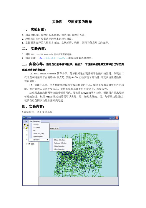
实验四空间要素的选择一、实验目的:1. 加深理解接口编程的基本思想,熟悉接口编程的方法;2. 理解图层几何要素选择的基本思想与思路;3. 掌握要素选择的几种基本方法,实现矩形、椭圆、圆形和任意形状的选择。
二、实验内容:1. 调用ESRI.ArcGIS.Controls接口实现要素选择;2. 通过创建class SelectByEllipseClass类编写要素选择程序。
三、实验心得:通过自己动手编写程序,总结了一下调用系统选择工具和自己写类实现选择功能的优缺点:(1)ESRI.ArcGIS.Controls简单易学,能够很好地实现基础平台接口的复用,体现出二次开发利用基础平台的特点;缺点是,仅能ArcGis已经实现了的功能,开发灵活性受限制,难以创新。
(2)创建工具类,优点是能够根据需要编写任意的工具,实现系统尚未封装在内的功能;但对编程人员水平要求高,要熟练掌握基础平台开发语言,难度较大。
这就要求在选择两种方法时慎重考虑。
要熟悉ArcGis的基本功能,根据用户需求要能够迅速知道,利用ArcGis该功能是否可以实现,是,如何实现的,否,与哪些功能类似,就要自己仿照次功能从基础类写起。
四、实验内容:1.功能展示:(1)菜单选项(2)矩形选择(3)圆形选择:(4)椭圆形工具选择:2.实现方法一:调用系统ESRI.ArcGIS.Controls实现(1)设置flag:strMouseDownCtl来获取鼠标按下的菜单。
用该方法仅实现了矩形选择和圆形选择。
private void retagelToolStripMenuItem_Click(object sender, EventArgs e){strMouseDownCtl = "RectSelection";}private void circleSelectionToolStripMenuItem_Click(object sender, EventArgs e){strMouseDownCtl = "CircleSelection";}(2)根据strMouseDownCtl获取的事件调用系统相应的选择工具case"RectSelection":{axMapControl1.CurrentTool = null;axMapControl1.MousePointer =ESRI.ArcGIS.Controls.esriControlsMousePointer.esriPointerCrosshair;IGeometry pGeom = axMapControl1.TrackRectangle();axMapControl1.Map.ClearSelection();axMapControl1.Refresh(esriViewDrawPhase.esriViewGeoSelection, axMapControl1.Map.ActiveGraphicsLayer, null);axMapControl1.Map.SelectByShape(pGeom, null, false);axMapControl1.Refresh(esriViewDrawPhase.esriViewGeoSelection,axMapControl1.Map.ActiveGraphicsLayer, null);break;}case"CircleSelection":{axMapControl1.CurrentTool = null;axMapControl1.MousePointer =ESRI.ArcGIS.Controls.esriControlsMousePointer.esriPointerCrosshair;IGeometry pGeom = axMapControl1.TrackCircle();axMapControl1.Map.ClearSelection();axMapControl1.Refresh(esriViewDrawPhase.esriViewGeoSelection, axMapControl1.Map.ActiveGraphicsLayer, null);axMapControl1.Map.SelectByShape(pGeom, null, false);axMapControl1.Refresh(esriViewDrawPhase.esriViewGeoSelection, axMapControl1.Map.ActiveGraphicsLayer, null);break;}3. 实现方法二:通过创建工具类实现选择(1)创建类:SelectByEllipse.csclass SelectByEllipseClass代码结构:(2)在Ellipse Selection菜单下编写响应事件private void ellipseSelectionToolStripMenuItem_Click(object sender, EventArgs e){SelectByEllipseClass selectByEllipse = new SelectByEllipseClass(axMapControl1, this.m_selectionProperty);}五、遇到的问题1.选择新的菜单时,先前使用的菜单没有释放,仍在作用。
gis二次开发实训报告
gis二次开发实训报告
一、实训概述
本次实训是基于GIS二次开发的实践活动,在导师的指导下,我选择了使用ArcGIS进行二次开发,并应用到一个具体的项目中。
本次实训的目的是锻炼我们的GIS应用能力,以及进一步理解和掌握GIS技术在实际项目中的应用。
二、实训过程
1.熟悉ArcGIS开发环境和工具
首先,我通过学习ArcGIS开发文档和相关教程,熟悉了ArcGIS的开发环境和常用工具。
这包括ArcGIS的API、ArcMap、ArcCatalog等。
2.需求分析与功能设计
3.页面布局与交互设计
在功能设计的基础上,我进行了页面布局和交互设计。
我借助ArcGIS提供的UI组件和控制器,设计了用户友好的界面,并考虑了不同设备的适配性。
4.功能实现与调试
5.优化与性能测试
在功能实现后,我对项目进行了性能测试和优化。
我利用ArcGIS提供的性能测试工具,评估项目的性能,并进行了相关优化,以提高应用的响应速度和用户体验。
6.报告撰写与总结
最后,我根据实训过程和成果,撰写了实训报告,并进行了总结。
我总结了本次实训的收获和经验教训,并展望了未来在GIS二次开发方面的进一步发展。
三、实训成果
四、心得体会
通过这次实训,我深刻认识到GIS技术在实际应用中的重要性和广泛性。
GIS二次开发不仅可以提供个性化的地图应用,也可以为各行各业的空间分析、决策支持等提供强大的支撑和解决方案。
同时,我也意识到GIS二次开发是一个不断学习和探索的过程,需要不断更新和提升自己的技术和知识。
我将继续深入学习GIS技术,并在未来的工作中更好地应用和发展。
GIS二次开发复习与总结
GIS二次开发
考试题型
一 判断题(每题1.5分,共15分) 二 填空题(每空1分,20分) 三 简答题(每题6分, 共18分) 四 程序题(47分)
两个程序填空题(16分) 四个程序问答题 (31分)
各章节的重点
第一章
1.1 地理信息系统定义、类型和构成 1.2 地理信息系统的研究内容 1.3 地理信息系统的功能 1.4 GIS软件的发展与技术 1.5 GIS软件的开发模式 1.6 GIS软件的开发内容 1.7 GIS软件开发的相关技术
FeatureDataSet等 4 Field的添加,删除,修改 5 Row object Feature 6 查询要素
重点 数据库的打开,要素的新增、修改、删除
第八章 Geometry与 空间分析
1 Geometry接口方法 2 几何对象编辑 移动几何对象 编辑几何对象的坐标
移动节点 增加节点 删除节点 ➢ 3 几何对象空间分析
各章节的重点
第三章
VBA开发环境 Application对象 ThisDocument对象 定制ArcMap的界面 使用Extension扩展ArcGIS
各章节的重点
第四章
常用控件简介 MapControl控件
地图文档的打开IMapDocument PageLayoutControl控件 ToolBarControl控件 TocControl控件 GlobeControl球体控件; SceneControl场景控件;
gis二次开发实习总结
gis 二次开发实习总结 篇一:gis 二次开发实习报告 重庆交通大学 测量与空间信息处理实验报告 实验课程:GIS 二次开发程序设计 实验名称:设计程序完成图像基本操作 班级: 测绘一班 学号: 09210111 姓名: 程 佳 琦 实验日期:2012 年 6 月 5 日 一、实验目的和要求 通过编写程序完成以不同的方式(包括菜单、对话框和命令按钮)加载图像,并完成对 图像的基本操作,包括放大、缩小和平移。
要求程序简洁界面整洁排列有序,能在正确设计程 序的基础上达到对于图像加载及简单操作的程序的熟练程度, 为二次开发的学习打下良好的基 础。
二、实验内容 运用 Visual Basic 设计程序,分别完成以菜单、对话框和命令按钮为对象的像加载,在加 载的基础上实现对图像的一些简单操作,设计程序完成对于图像的一些简单的操作,如放大、 缩小和平移等。
三、实验步骤 1.设计程序完成菜单加载,并且完成相应放大、缩小和平移。
1)设计程序如下: 2)程序运行: 3)打开图像并放大: 4)图像缩小: 5)图像平移: 2.设计程序完成对话框图像加载,并完成相应的基本操作,包括图像的放大、缩小和平 移。
1)设计程序: 2)程序运行: 篇二:GIS 开发实习报告 学号 1221030205 实习报告 1 / 7GIS 程序设计实习 起止日期:2015 年 7 月 13 日 至 2015 年 7 月 19 日 学 班 成生姓名 级 绩 吴馁 12 级地信 2 班 指导教师(签字) 地质与测绘学院 2015 年 7 月 20 日 GIS 程序设计实习 一、实习目的 通过 GIS 程序设计实习,使学生了解需求分析、项目管理方案设计、系统总体设计以及 系统详细设计、系统实施、运行和维护等阶段要完成的具体工作;掌握在 C#和 ArcEngine 环境 下构建应用型地理信息系统的方法。
二、实习内容 熟悉开发环境: Visual Studio 2010; C#; Arc Engine 10.1 功能需求分析 基于组件技术开发应用型地理信息系统 组件式技术已成为当今软件技术的潮流之一。
gis二次开发实习总结

gis 二次开发实习总结 篇一:gis 二次开发实习报告 重庆交通大学 测量与空间信息处理实验报告 实验课程:GIS 二次开发程序设计 实验名称:设计程序完成图像基本操作 班级: 测绘一班 学号: 09210111 姓名: 程 佳 琦 实验日期:2012 年 6 月 5 日 一、实验目的和要求 通过编写程序完成以不同的方式(包括菜单、对话框和命令按钮)加载图像,并完成对 图像的基本操作,包括放大、缩小和平移。
要求程序简洁界面整洁排列有序,能在正确设计程 序的基础上达到对于图像加载及简单操作的程序的熟练程度, 为二次开发的学习打下良好的基 础。
二、实验内容 运用 Visual Basic 设计程序,分别完成以菜单、对话框和命令按钮为对象的像加载,在加 载的基础上实现对图像的一些简单操作,设计程序完成对于图像的一些简单的操作,如放大、 缩小和平移等。
三、实验步骤 1.设计程序完成菜单加载,并且完成相应放大、缩小和平移。
1)设计程序如下: 2)程序运行: 3)打开图像并放大: 4)图像缩小: 5)图像平移: 2.设计程序完成对话框图像加载,并完成相应的基本操作,包括图像的放大、缩小和平 移。
1)设计程序: 2)程序运行: 篇二:GIS 开发实习报告 学号 1221030205 实习报告 1 / 7GIS 程序设计实习 起止日期:2015 年 7 月 13 日 至 2015 年 7 月 19 日 学 班 成生姓名 级 绩 吴馁 12 级地信 2 班 指导教师(签字) 地质与测绘学院 2015 年 7 月 20 日 GIS 程序设计实习 一、实习目的 通过 GIS 程序设计实习,使学生了解需求分析、项目管理方案设计、系统总体设计以及 系统详细设计、系统实施、运行和维护等阶段要完成的具体工作;掌握在 C#和 ArcEngine 环境 下构建应用型地理信息系统的方法。
二、实习内容 熟悉开发环境: Visual Studio 2010; C#; Arc Engine 10.1 功能需求分析 基于组件技术开发应用型地理信息系统 组件式技术已成为当今软件技术的潮流之一。
基于MAPGIS组件的二次开发
基于MAPGIS组件的二次开发的报告,800字MAPGIS组件二次开发报告
本报告详细阐述了一种基于MAPGIS的二次开发方案。
MAPGIS 是MAP Studio地理信息软件的核心插件,此报告主
要讨论MAPGIS组件的二次开发实施过程。
首先,需要对MAPGIS组件的功能进行详细的了解,包括接口、数据结构、算法等。
其次,建立一个良好的系统架构,将原有的MAPGIS组件与新实现的组件进行集成。
同时,应当
进行客户端测试,以确保系统功能正常。
接着,应当着手编写MAPGIS二次开发脚本和程序。
其中,
脚本应该独立出来,且应当使用已有的MAPGIS组件API,
以便能够有效地实现基于MAPGIS的二次开发目的。
编写完
成后,应当进行调试,以确保程序编写的正确性,以及确保程序的有效性。
最后,基于MAPGIS的二次开发也应当完成性能测试。
此外,应当利用可用的工具,如MAP Studio SDK,完成代码优化,
以确保可用的最佳性能。
总的来说,MAPGIS二次开发方案涉及到多个不同的环节,从了解MAPGIS组件的功能,到编写脚本以及性能测试,都是
必须进行的步骤。
在此基础上,MAPGIS可以帮助开发者更好地实现其设计目标,从而实现更好的功能要求。
二次开发实习报告
资源环境与旅游学院ArcGIS二次开发实习报告班级:地信11101姓名:罗丽学号:201114030110、指导老师:李巍日期:2014年11月01日一、实习目的本学期通过对ArcGIS软应用以及二次开发的学习,通过使用该软件对月脊数据资料进行分析,综合应用ArcGIS软件的功能模块,按照相应的要求完成此次实验(如:计算每条月脊的长、宽、角;统计每条月脊内的撞击坑个数;统计每条月脊线的最大高差;统计月脊公测高程偏移)。
熟练地掌握Arcgis软件功能模块的各个作用,以及理解月脊相关参数的计算原理,能综合地形成相应的处理能力。
特别注意:月脊数据的保存位置以及背景环境的设置(坐标系)二、实习要求(1)计算每条月脊的长、宽、角(2)统计每条月脊内的撞击坑个数(3)统计每条月脊线的最大高差(4)统计月脊公测高程偏移三、实习步骤步骤一:将提取的月脊转换成多边形。
1. 打开Arcgis,点击ArcCatalog,在文件夹下面(不是在Geodatabase 下面)新建一个类型为polygon的shapefile,命名无所谓,假设命名为polygon.shp,点击Edit按钮,在弹出的对话框中点击Import按钮,将其坐标系设置与ridge图层一致的其空间参考,即GCS_Moon_2000。
此处contain M和contain Z复选框都不用勾选。
2. 运行程序,点击按钮添加geodatabases中的ridge和新建的polygon.shp, ridge要排在前面(如下图左侧),然后点击按钮,将把ridge的线要素全部转成多边形,结果如下图右侧。
注意:(1)如果ridge文件中存在圆形或其它非矩形图形的话,运行时会弹出错误消息"not five nodes",这时会阻断程序,需要手动点击ok 才能运行完”。
点击该按钮时需保证polygon.shp内记录为空,否则会重复添加;因此,为保证顺利运行,可将ridge文件中的非矩形图形删除。
ARCGIS二次开发复习重点
1、在MapX中,图层的空间参考可以通过Layer.CoordSys属性来获取或者设置。
MapX 的Map对象的空间参考则可以通过Map.DisplayCoordSys和Map.NumericCoordSys属性来设置,前者是显示的坐标,后者是实际的坐标。
如果你把前者设置为经纬度,后者设置为投影坐标,那么通过Map的工具量测得到就是前者的坐标单位,而通过FeatureFactory对象添加属性,使用的坐标就是后者。
那么对应层和Map对象空间参考不一致的情况,显示的时候就要实时(onfly)变换。
2、关系:OLE是一种面向对象的技术,利用这种技术可开发能重复使用的COM。
实现ArctiveX的基础是COM。
ArctiveX提供了封装COM组件和将其置入应用程序的一种方法。
3、OLE:对象连接和插入,简称OLE技术。
OLE不仅是桌面应用程序集成,而且还定义和实现了一种允许应用程序作为软件“对象”(数据集合和操作数据的函数)彼此进行“连接”的机制,是在客户应用程序间传输和共享信息的一组综合标准。
4、ArcEngine:ArcGIS Engine是用于构建定制应用的一个完整的嵌入式的GIS组件库。
利用ArcGISEngine,开发者能将ArcGIS功能集成到一些应用软件中,还可以为用户提供针对GIS解决方案的定制应用。
由构建软件所用的开发工具包以及使已完成的应用程序能够运行的可再发布的Runtime 组成。
5、C#的特点:1.语法简洁2.彻底的面向对象设计3.与Web应用紧密结合 4.强大的安全机制5.完善的错误、异常处理机制 6.灵活的版本处理技术 7.兼容性6、与以前的ADO 相比,主要引入了以下几个新特性:对 XML 的支持,引入新数据,对(DataSet)语言无关的数据访问7、Mapinfo软件开发思想:(1)尽可能向微软公司产品的操作特性靠拢(2)全方位支持单用户环境、客户机/服务器环境和网络环境等各种体系结构(3)支持ODBC技术,使不同的数据库系统之间可以进行数据共享和链接(4)具有类Basic的二次开发语言8、Mapinfo功能特色:属性数据、因特网、统计图表、图层套叠、拖曳功能、影像功能、连接GPS、主题图、数据格式转换、数据库连接、SQL查询语言9、MapInfo数据组织:属性数据的表结构文件.TAB,属性数据文件.DAT,交叉索引文件.ID,空间数据文件.MAP,索引文件.IND10、Mapinfo professional特点:加强支持的操作系统、加强支持的数据库、更简洁的使用接口、新增支持格式、新增对象编修功能、新增对象处理方法、改良的指北针工具、新增加数据整合功能、更多新增的附加程序、新增的投影选择11、Mapx主要功能:地图选择工具、栅格图像和格网的支持、专题图、对象编辑与处理、标注、查询、数据绑定、工具、图层管理、数据访问和数据库支持12、Mapx v5.0特性:快速应用开发、强大的地图功能、空间数据库和空间支持、用户控制、选择数据、免费数据、支持军事栅格格式和军事网络参考系统、支持ODBC数据源13、ActiveX:是使软件组件能够在网络环境中交互作用而与创建组件的语言无关的一套封装技术14、ActiveX组件:一个应用程序或开发工具,可以使用另一个应用程序支持的对象,或者提供自己的对象供另一个应用程序使用。
- 1、下载文档前请自行甄别文档内容的完整性,平台不提供额外的编辑、内容补充、找答案等附加服务。
- 2、"仅部分预览"的文档,不可在线预览部分如存在完整性等问题,可反馈申请退款(可完整预览的文档不适用该条件!)。
- 3、如文档侵犯您的权益,请联系客服反馈,我们会尽快为您处理(人工客服工作时间:9:00-18:30)。
ptLst.Add(m_Geometry as Point);
m_GeoPtCol.Add(ptLst);
pGeoCol = m_Geometry as GeometryCollection;
for (int i = 0; i < pGeoCol.Count; i++)
{
IRing pRing;
ILine pLine=null;
ISegmentArray pSegmentArray=new RingClass();
Point prePoint = null;
Point nextPoint = null;
bre方法
lstPart.SelectedIndexChanged += new EventHandler(lstPart_SelectedIndexChanged);
dgv_Points.CellClick += new System.Windows.Forms.DataGridViewCellEventHandler(dgv_Points_CellClick);
//if (pFeature == null)
//{
// MessageBox.Show("未选中要素!!!");
// return;
//}
IGeometry pGeometry = m_Feature.Geometry;
{
nextPoint = new PointClass();
nextPoint.X = Convert.ToDouble(dgv_Points.Rows[i].Cells[1].Value);
{
IGeometryCollection pPolyline = new PolylineClass();
pPolyline.Add(pPath as IGeometry);
m_Feature.Geometry = pPolyline as IGeometry;
pPath = pGeoCol.GetAt(i) as IPath;
IPointArray pPtAry;
pPtAry = pPath as IPointArray;
item.Click += new EventHandler(item_Click);
cMenu.Items.Add(item);
ToolStripMenuItem itemDeleteRow = new ToolStripMenuItem("删除点");
ISegmentArray pPath = new PathClass();
for (int i = 0; i < dgv_Points.Rows.Count; i++)
{
if (prePoint == null)
pLine = new LineClass();
prePoint = nextPoint;
}
}
if (pGeometry.GeometryType == geoGEOMETRYTYPE.GEO_GEOMETRY_POLYGON)
nextPoint.X = Convert.ToDouble(dgv_Points.Rows[i].Cells[1].Value);
nextPoint.Y = Convert.ToDouble(dgv_Points.Rows[i].Cells[2].Value);
IGeometry pGeometry = m_Feature.Geometry;
ILine pLine = null;
ISegmentArray pSegmentArray = new RingClass();
m_GeoPtCol.Add(PtArrayToPtLst(pPtAry));
}
break;
case geoGEOMETRYTYPE.GEO_GEOMETRY_POINT:
}
m_Feature.Store();
System.Runtime.InteropServices.Marshal.ReleaseComObject(m_Feature);
MFeature = m_Feature;
{
IRing pRing = pSegmentArray as IRing;
pRing.Close();
IGeometryCollection pPolygon = new PolygonClass();
i++;
}
if (nextPoint != null)
{
nextPoint = new PointClass();
pGeoCol = m_Geometry as GeometryCollection;
for (int i = 0; i < pGeoCol.Count; i++)
{
IPath pPath;
itemAddPoint.Click += new EventHandler(itemAddPoint_Click);
cMenu.Items.Add(itemAddPoint);
this.dgv_Points.ContextMenuStrip = cMenu;
nextPoint.Y = Convert.ToDouble(dgv_Points.Rows[i].Cells[2].Value);
pLine = new LineClass();
prePoint = nextPoint;
pRing = pGeoCol.GetAt(i) as IRing;
IPointArray pPtAry;
pPtAry = pRing as IPointArray;
ContextMenuStrip cMenu = new System.Windows.Forms.ContextMenuStrip();
ToolStripMenuItem item = new ToolStripMenuItem("导出坐标");
pPolygon.Add(pRing);
m_Feature.Geometry = pPolygon as IGeometry;
}
if (pGeometry.GeometryType == geoGEOMETRYTYPE.GEO_GEOMETRY_POLYLINE)
}
public void DeletePoint()
{
//getPtCol();
int rowIndex = -1;
rowIndex = dgv_Points.CurrentRow.Index;
itemDeleteRow.Click += new EventHandler(itemDeleteRow_Click);
cMenu.Items.Add(itemDeleteRow);
ToolStripMenuItem itemAddPoint = new ToolStripMenuItem("添加点");
1、从集合体中提取点集的方法
m_GeoPtCol = new List<List<Point>>();
switch (m_Geometry.GeometryType)
{
case geoGEOMETRYTYPE.GEO_GEOMETRY_POLYLINE:
顶点编辑方法
public void AlterPoint()//修改面要素顶点坐标
{
//IFeature pFeature = m_Feature;
//IFeatureClass pFeatureClass = pFeature.FeatureClass;
pLine.PutCoords(prePoint, nextPoint);
pSegmentArray.Add(pLine as ISegment);
pPath.Add(pLine);
m_GeoPtCol.Add(PtArrayToPtLst(pPtAry));
}
break;
case geoGEOMETRYTYPE.GEO_GEOMETRY_POLYGON:
