新北京的时代地标———温榆河生态走廊(朝阳段)规划设计
河道开挖及填筑方案设计
温榆河综合治理工程施工第3标段土方开挖及填筑方案编制单位:中电建建筑集团有限公司通州区温榆河综合治理工程项目经理部编制人:审核人:日期:年月日土方开挖方案................................................................................................. 错误!未定义书签。
一、工程概况: (3)二、编制依据 (4)三、施工特性 (4)四、植被清理、垃圾清运 (5)1.植被清理 (5)2.垃圾清运 (5)五、土方开挖 (5)1.河道开挖的设计要求 (6)2.边坡的开挖 (6)3.建筑物基础的开挖 (7)4.开挖前准备工作 (7)5.开挖要求 (8)六、土方填筑 (9)1、料源复核 (9)2、现场生产性试验 (9)3、填筑料的装运 (14)七、堤防填筑 (15)1、岸堤基础处理 (15)2、填筑一般要求 (15)3、填筑施工 (15)八、建筑物周边回填 (17)九、质量检查和验收 (18)1、填筑前的质量检查和验收 (18)2、施工期的质量检查和验收 (18)土方开挖及填筑方案一、工程概况:温榆河属于海河流域北运河水系,北运河水系以通州区北关闸为界,北关闸以上成为温榆河,北关闸以下称为北运河。
北运河河道干流长142.7km,总流域面积6051k㎡。
北京市界内主河长89.4km,流域面积4250k㎡,占总面积70%。
温榆河通州境内河道长14.5km,流域面积25.5k㎡,是通州与朝阳的边界河。
北运河干流段河道治理标准为50年一遇,通州新城的防洪标准为100年一遇,新建宋庄蓄滞洪带,蓄滞超过50年一遇的洪水,使通州城市副中心段温榆河可达到100年一遇防洪标准。
本工程治理起点为温榆河干流通州界,终点为新北关闸拦河闸,治理段河道总长度约16.06km,其中主河道长度为14.73km,由于温榆河新建尹各庄拦河闸段(桩号7+367-8+067)已纳入宋庄蓄滞洪区二期工程,故主河道治长度为14.03km;支沟治理范围为末端新北关闸分洪闸至通顺路,治理长度为2.03km。
绿色空间的再造,重塑生物栖息地——以北京温榆河公园(一期)概念方案为例
2020年8月'设计绿色空间的再造,重塑生物栖息地——以北京温榆河公园(一期)概念方案为例刘芳宏刘佩茹(岭南设计集团有限公司东莞分公司,广东东莞523000)摘 要:城市永续发展的核心,在于处理好城市与人、自然的关系。
这恰若庄子的“天地与我共生,而万物与我为一”,也是中国人自古追寻的“天人合一”境界。
当我们以生态文明理念为引领,深入践行“绿水青 山就是金山银山”理念,以生态视野在城市构建山水林田湖草生命共同体、布局高品质绿色空间体系,将“城 市中的公园”升级为“公园中的城市”,必然呈现人与自然和谐发展的新格局。
北京市温榆河公园,以绿色空 间的再造,重塑生物栖息地,通过生态修复和自然保育,实现城市更新的可持续发展。
关键词:绿色;生态;生物栖息地 文章编号:2095 -4085 (2020)08 -0024 -021项目背景温榆河公园(一期)位于北京市朝阳、顺义、 昌平三区交界的重要位置,位于城市第二道绿化隔离带中,承担着国际空港、艺术文化、科技创新、全球商贸和高端社区等多项功能,是国际职能的集中承载 地。
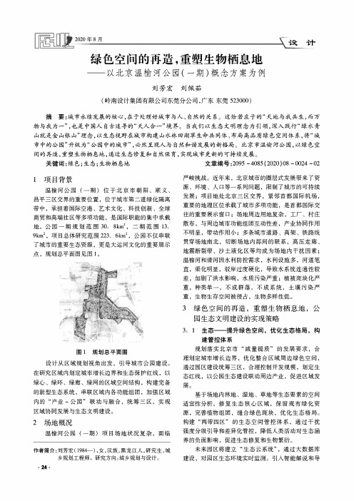
公园一期规划范围30. 8km 2,二期范围13.9km 2,项目总体研究范围223. 6km 2,公园不仅串联了城市的重要生态资源,更是大运河文化的重要展示点,规划总平面图见图1。
图1规划总平面图设计从区域规划视角出发,引导城市公园建设。
在研究区域内划定城市增长边界和生态保护红线,以绿心、绿环、绿廊、绿网的区域空间结构,构建完备 的新型生态系统,串联区域内各功能组团,加强区域内的“产业-公园”联动与融合,统筹三区,实现 区域协同发展与生态文明建设。
2场地概况温榆河公园(一期)项目场地状况复杂,面临作者简介:刘芳宏(1984-),女,汉族,黑龙江人,研究生,城乡规划工程师。
研究方向:城乡规划与设计。
严峻挑战。
近年来,北京城市的圈层式发展带来了资源、环境、人口等一系列问题,限制了城市的可持续 发展;项目地处北京三区交界,紧邻首都国际机场,重要的地理区位承载了城市多项功能,是首都国际交 往的重要展示窗口;场地周边用地复杂,工厂、村庄 散布,与周边城市功能组团互动性差,产业协同作用不明显,带动作用小;多条城市道路、高架、铁路线 贯穿场地南北,切断场地内部间的联系,高压走廊、地震断裂带、沙土液化区等均成为场地内干扰因素; 温榆河和清河因水利防控需求,水利设施多,河道笔 直,渠化明显,驳岸过度硬化,导致水系统连通性较 差,加剧了洪水影响,水质污染严重;植被斑块化严 重,种类单一,不成群落,不成系统,土壤污染严 重,生物生存空间被侵占,生物多样性低。
北京八大别墅区发展

伟业格拉斯项目组
北 京 传 统 别 墅 区 分 布
“一山”——西山,从 门头沟、八大处、香山 直至温泉永丰乡
“二河”——潮白河、 温榆河两河流域别墅带
“三线”——立汤、京顺、 京通
“四高”——京昌、京沈、 京开、京密四条高速路
从传统和业界普遍的接受度来讲,人们更习惯区域的分类方式
国门商务区西起中央别墅区,东至东六环,北接机场,南临机场南线。总规划面积19.65平方公里,可开发建设面积
9.65平方公里。按照产业和空间整体规划为航空商务办公区、机场服务办公区、商业综合服务区、航空产业配套区、 国际商务核心区等五个功能组团。
新中国国际展览中心位于顺义区天竺,北京市顺义空港工业开发区西侧,东邻首都国际机场,西靠
配套
教育:汇佳幼儿园,亚奥幼儿园 ,景山学校分校,汇佳学校 ,中央戏剧学院, 北京邮电大学昌平校区,北京商业学校,北京人文大学,北师大亚太实验学校, 沙河大学城(北京师范大学、中央财经大学、北京航空航天大学、北京邮电大 学、外交学院等高校已签约入住) 医疗:回龙观医院、太阳城医院、安贞医院分院 购物:华汇北辰超市、飘亮购物中心、第五大道,北辰购物中心、九华山庄国 利超市、王府中西医结合医院、、阳光广场、家和超市 餐饮休闲:九华山庄、温都水城、鲍鱼岛、高地高尔夫,小汤山疗养院、龙脉 温泉度假村、鸿华高尔夫球场
阜石路
教育配套:北京大学、清华大学、北京外国语大学、北京理工大学、人民大学、 教育配套: 首都师范大学、国防大学、中国农业大学、国际关系学院、北京理工大学分校等。 另外拥有北大附小、人大附小、北外附小、中关村小学、中关村二小、人大附中、 北大附中、清华附中、八一中学等 山水园林:香山、玉泉山、万寿山等;园有金山陵园、森林公园、希望公园、巨 山水园林: 山农场、四海水上乐园、松林公园、百旺山森林公园等;水有昆明湖、长河、永 定河引水渠。皇家园林、现代游玩胜地比比皆是——香山公园、石景山游乐园、 八大处公园、颐和园、圆明园、玉泉山公园、紫竹院公园、动物园、天文馆、北 京植物园、北京海洋馆、昆运河航线等。
北京温榆河项目规划设计任务书
北京温榆河项目规划设计任务书(总25页)-CAL-FENGHAI.-(YICAI)-Company One1-CAL-本页仅作为文档封面,使用请直接删除规划设计任务书项目名称:温榆河项目(暂名)项目地点:北京昌平小汤山镇土沟村温榆河边建设单位:北京首发房地产有限公司【设计任务书讨论稿编制说明】1、本设计任务书是甲方在基于对项目综合研判的基础上,对项目前期定位的总结和对规划设计要求提出的一些分析和结论性意见,对设计单位进行设计起指导作用;2、本设计任务书讨论稿仅作为首发地产公司和设计方进行项目设计第一轮沟通时的相关参考资料;3、本设计任务书讨论稿中确定的相关技术经济指标均为前期市场研判得出的结论性定位,设计单位可以在一定幅度内进行调整;4、本设计任务书主要针对首发温榆河项目整体规划提出。
目录:§1 项目概况一、基地情况二、气候及土壤资料三、基地社会概况及分析四、规划要求五、市政管线§2 市场定位及产品建议一、市场定位二、项目产品建议§3 概念分析研究结论一、概念设计研究方案简述二、设计目标三、规划方面的结论§4 方案设计中需要解决的问题一、规划方面的问题二、技术方面的问题§5 设计成果文件要求§6 基础资料一.项目地块红线图(AUTOCAD电子文件)二.项目地块照片(电子文件)三.概念设计方案总图§1 项目概况一、基地情况1.用地地点本项目位于规划北五环与北六环之间、昌平小汤山镇土沟村,东接规划的京承高速公路,西侧为小汤山镇土沟村,南临温榆河。
区域位置图宗地位置示意图2.周边道路东侧:建设中的京承高速公路,出入小区规划有二进一出共三个出入口;北侧:规划路;西侧:规划路南侧:规划滨河路其中西、北、南侧的现状道路均为区县级及村镇级道路,道路档次及通行能力较差。
建成后将成为本项目住户出行的主要交通线路。
3.周边环境本项目位于规划空港城、北七家镇、小汤山镇的大东流组团、高丽营镇中间,周边以自然村落和耕地为主。
新北京的时代地标———温榆河生态走廊(朝阳段)规划设计()

新北京的时代地标———温榆河生态走廊(朝阳段)规划设计()Ecology - as a permanent theme, is the primary factor to consider in planningLandscape - ecological planning in the landscape will create a new landscapeBeijing - the world city of the future, the concept of the global environment should be emphasized1 Analysis of the status quoIn the range of Wenyu River Ecological Corridor in the 45km2 below has great influence on some characteristics for planning:(1) the Wenyu River on the east side of the site and Qinghe interchange with ponds, pools of water, forming a natural wetland; site on the west side of the pond area status was a history of natural wetland; old bend zone environment in good condition. New water systems can be developed using these current wetlands and water systems.(2) Huang Gang Xiang and House floor is the current situation of farmland intensive areas, the existing land reserve should be considered.(3) the existing rivers have serious environmental pollution, river ecosystem degradation, loss of self purification capacity, simplification and even loss of river function; deterioration of hydrological characteristics caused by natural geomorphic changes. There are many ditches and shouldbe properly utilized.(4) the current status of agricultural production as the main industry, long-term consideration of the overall relocation of the ecological corridors, therefore, the employment of these people should be fully considered.2 programme originality and features2.1, four strategies2.1.1 function strategy -- regional integrationWe focus on the overall planning to grasp the Wenyu River Ecological Corridor from the area. Regional city is composed of several communities (community), each of which has the size of supporting modern economic life and urban infrastructure. In addition to the function of residence, each community has one or more special functions that serve the group - Industry and commerce, culture and education, finance and administration, recreation and recreation. The community is surrounded by a natural green belt that maintains a good environment and controls the spread of the community. The open space between communities will be permanently preserved and used only for agriculture, forestry and recreation. The convenient highway system is in all directions, and connects with the expressway which is not through the town, so the traffic is very convenient.According to the regional city view, in the scope of 110km2, the overall consideration of industry and space layout. Inaddition to the Wenyu River Ecological Corridor of the 65KM2 range, the planning of the 4 characteristics of the town, they will take on different function areas.2.1.2 -- nature ecological strategyFrom a sustainable point of view, the earth we inhabit is not ours, it is only borrowed from our descendants for the time being. What kind of earth will we return to the next generation? This is a problem that planners and builders must face up to. In the planning and construction of the Wenyu river ecological corridor, the first problem is how to build a "green environment for human attachment". Therefore, imitation of nature, "the concept of ecological design of water - Green -" three-in-one will run through the entire process of the project.2.1.3 transportation strategy -- organic evacuationOrganic evacuation theory, like the human body as a living evacuation overcrowded city, a group of organization of city life, the result is a group of functional layout type and dendritic road traffic system. In Wenyu river ecological corridor planning, we adopt the road traffic system, clear dendritic structure. The roadway is divided into clear road and service road two: high-speed road, expressway, trunk road of dredge Road, smooth, fast convergence, good relations with the center of the city; the roads and slip roads constitute the service road, directly to the land, there is enough parking space. Within the ecological corridor, a continuous pedestrian walkway system and a bicycle road are planned to meet the needs of people's recreational activities while satisfying trafficfunctions2.1.4 industry strategy -- chain structureWenyuhe area industrial development to solve problems in two aspects: one is the relocation of local agricultural residents, to properly solve the employment problem of this part; two is to introduce a new type of industry, the revitalization of the local economy. We put forward the concept of industrial chain, aimed at forming a corridor related to the ecological corridor parallel industries.2.2, five landscapeThe principles of landscape planning Wenyuhe ecological area is with water as the axis, green body, people-oriented".4 expressways (Chengde, Beijing Road, airport expressway, airport first channel) the ecological corridor is divided into5 different styles of functional groups, respectively, formed Island Township, Bu, Lin, Tian 5 landscape features, they will assume the residence, commerce, recreation, sports and other farming, comprehensive functions, to people or poetry, or song, or painting, or a dream, or different psychological feelings.2.2.1 Island - wetland landscape (Poetry)Wenyu River Ecological corridor,From the west, East is the "island" (wetland landscape area), the main function for living, leisure and sightseeingagriculture. The water system forms a self - circulation system in this region. Living in about 1/4 of the area, to high-grade low density community based, around the community around the wetland water system. The farmland accounts for about 1/3 of the area, and the rest is open wetland tourism area.Wenyu river ecological corridor to the east of the river, fish ponds, dense pool existing constitute a unique natural wetland landscape. In order to prevent the negative impact of human economic activity for the ecological function of wetland ecological engineering, but useful for wetland restoration and reconstruction, applying active positive intervention for existence and natural succession of wetland, in order to give full play to the ecological value of wetland. Therefore, the scheme restored the existing natural wetlands in the eastern side of the ecological corridor, and constructed a large number of artificial wetlands to form wetland areas. The island's high standard residential sites are lined up with a continuous, branching wetland system. Here the growth of a plant rich wetland lotus, reed, there are all kinds of fish and birds, the formation of a "wild goose sound Lu Ye old aesthetics, Heron shadow flower cold".2.2.2 Township - rural landscape (song)Maquanying Road West Beijing Road, east part of "Xiang" (rural landscape area), the main function is to live and agriculture. This is a new type of residential and farmland interwoven living form, near the residential area is a large modern farm. In this area there are 3 concentrated residential groups, residential development is mainly low density and high standards ofcommunity, a large lake can be shared between them, the lake from the Wenyu River system. Low density residential areas are intertwined with large tracts of farmland, and fields can be large modern farms. The new residential development complements the existing village atmosphere and creates a new form of residence - township. People walk out of the house, stroll through the soothing fields, see the green wheat fields, and experience the leisurely life of the country. All this is like a rustic idyll.2.2.3 port - dock landscape (painting)Between Beijing Road and airport road at high speed, "bu" (dock landscape) area, with the function of commercial entertainment. The area retains a status of the villa area. Here, according to the "Wenyuhe water" and other records and qingmingshanghetu provide city life picture, planning to restore a waterfront town. The town is bounded by bridges across the river. This is the central area of the Wenyu river ecological corridor, but also the public activities in the most intensive areas. Inside the small town restaurant, restaurants, shops, restaurants and other buildings, and karaoke bars and other leisure entertainment. The town is very popular and lively, whether it is day or night. Here the construction scale is not big, layout form is flexible, naturally - although planning, but as if spontaneously formed, has its own internal order.A beautiful arch bridge across the river, like a rainbow lying wave, with the Qingming Riverside bridge with the same name "Hongqiao". People can see the crowd on the bridge on both sides of The stream never stops flowing., can also see the boats onthe water, enjoy the taste of flourishing downtown -- of course also imperceptibly become the scenery on the bridge.2.2.4 forest - woodland landscape (dream)Between the airport expressway and the first channel of the airport is the "forest" (woodland landscape) area, which is mainly residential and sightseeing. Here is the old bend of the river, the historical and cultural atmosphere is strong, there are good preserved old trees and trees, planning to repair it, forming a forest landscape. We slightly comb the old river system, forming more rivers, between the river and dense forest, planning residential buildings. Residential buildings here take the layout of the end of the road, residential and jungle blend, forming a fairy tale quiet and mysterious mood. The old bay planning public area, intersection of old cove and Wenyu River to form a larger park. People can play along the old river bend, in this coherent public space, in accordance with historical legends set different attractions, the historical legend and beautiful scenery as one.2.2.5 Tian -- pastoral landscape (love)To the west of the first channel of the airport is the "Tian" (rural landscape) area, with sightseeing, agriculture and sports and leisure functions as the main functions. This is the noise affected area of the airport, so it does not arrange the living community here, but retains the attributes of its farmland. At the same time, existing fish ponds and ponds are retained and expanded to form irrigation water areas. In addition, wetlands are formed at the westernmost end of theecological corridor, echoing the wetlands on the East side. There is an ecological farm equipped with modern farming tools, built on the site of the former village. In addition, here with the planning of sports leisure, along the Wenyu river opened the racecourse, fitness runway and other sports facilities.The feeling of this area is very wide.The scheme retains the status quo as a modern farm landscape area. The vertical horizontal road network show "Qianmo traffic" spectacular, modern mechanization of agricultural production will be used here. Reserve existing ponds, as crabs and other aquatic animal breeding areas, in the future will be held here "crab Festival" and other agricultural tourism projects. And on the basis of the original village built farms, buildings and sports facilities, the region into Beijing sightseeing agriculture and sports leisure demonstration field.2.3 Characteristic TownsWithin the scope of 65KM2's expansion, we have planned 4 towns with different functions and styles, with vast farmlands and green spaces between the towns. From the east to the West are high-tech industries, small towns, commercial and trade towns, domestic service towns, agricultural tourism town.2.3.1 hi tech industry townIn the Beijing Chengde expressway between and Laiguangying road is a high-tech industrial town, area of 2.33km2, which canaccommodate 18 thousand people. In this area, we will arrange high-tech industrial clusters and residential land. The environment in this region can continue the "island", that is, the environmental features of wetland landscape, and create a green ecological environment, so as to attract well-known high-tech enterprises at home and abroad settled in the park. In the middle of the town are sports and fitness facilities and Convention centers.2.3.2 commercial townIn between, West Road and Beijing Road, is a commercial trade town. The area is 3.34km2, which can hold 26 thousand people. This area is mainly commercial, trade and residential land. The whole town is Wenyuhe regional commercial and Trade Center, there are supermarkets, shopping malls, commercial streets, markets, hotels and other commercial buildings. It has a convenient connection with the port (Waterfront Business District).Commercial trade town is very easy to form a position through the "city - Wangjing - trade - port town (Waterfront Business District) - Airport commercial trade corridor, it is an important part of the industrial chain, but also Wenyuhe areas of commercial and trade center. The landscape style of the town is dominated by lively and popular commercial style.2.3.3 housekeeping service townIn the north east of the village shop long Wenyuhe Avenue South of town is home service. The area is 2.04km2, which can hold16 thousand people. This area is mainly residential and integrated community facilities for land use. There are international schools and hospitals in the town. There are various domestic service companies and landscaping units in the town, which can provide modern housekeeping services for the surrounding communities. At the same time, providenon-agricultural employment opportunities for relocated agricultural residents. Residential development in the town to multi-storey residential buildings mainly, relatively high density. The style of landscape architecture in the small town is integrated, and many styles can coexist under a unified tone.2.3.4 agriculture, tourism, townIn the east of the first channel of the airport, both sides of the road are planned to be agricultural and tourist towns. The area is 2.02km2, which can hold 16 thousand people. The main function of the town is to live, residential multi-storey buildings based, mainly for residents relocated. The architectural style has the traditional characteristic, in the town forms some has the ancient town amorous feelings small street, the town center is the commercial street. The residents here are mainly engaged in agricultural production and processing of handicrafts. Housing is generally pre - store and post - residence, and tourism trade is thriving.3 ecological environment3.1 water system planningSpecial emphasis for landscape planning and water treatment,in order to be based on the original Wenyu River system, and re opened up a new water temperature and parallel to the river. Landscape treatment of the original river bed, the formation of river bed Park, combined with people's sightseeing activities, as a landscape display area.The principles and practices of regional Wenyuhe water system planning:(1) retaining existing channels and embankments, leaving no lining for river courses, slopes and rivers.(2) open up new artificial wetland ecological corridor in the western region, in order to increase the capacity of flood storage, at the same time with the original natural wetland to form rich wetland landscape.(3) diverting water from the canal. In the local area, a new channel is excavated to warm the water of the elm River into each living group, or to form a lake surface at the node so as to increase people's water surface. At the same time, the new system can also increase the flood and climate effect.(4) reconstruction of drains. Status quo of Wenyuhe area drainage ditches are arranged in a crisscross pattern, village level of nearly 50, has great influence on the water system and landscape area. Based on the field investigation in combination with site planning, put forward new ideas on the drains, in maintaining the status quo of the drainage system to meet the requirements under the premise of flood control and drainage, appropriate transformation drains, make comprehensive floodcontrol, drainage, water purification, biological landscape, entertainment and other functions.3.2 green planning(1) try to preserve native vegetation on existing sites, and use indigenous species of Beijing as far as possible.(2) along the Wenyu River edge,Plan minimum width of 100m shelterbelt to form natural edge. Traffic shelterbelt in the forest belt is connected on both sides of highway and expressway, the formation of forest system, it formed a green wedge into the city, connecting the Wenyu River and the city green corridor.(3) along the Wenyu river flow direction, according to the actual situation of the land, forming the island, township, port, forest, fields 5 planting patterns. Such as "island" in the region to the wetland system as the foundation, aquatic and wetland plants layout of forest group; in rural areas formed the farmland forest belt and interspersed with each other form; form courtyard planting form in the port area.(4) according to the law of succession of organisms, the proportion of fast-growing trees and dominant trees should be rationally allocated. The formation of Shelterbelts offast-growing trees such as poplar, willow, Salix, Fraxinus, Ailanthus altissima, composed of Paulownia in the near future, in the long term to form dominant species such as ginkgo, locust, walnut, pine and other species as the main body, the stabilityof the ecological corridor.3.3 ecological planning(1) organic revetment. All the river banks and the bottom of the river are not made of hard lining.(2) the grass into the water to aquatic plants and willow, Metasequoiaglyptostroboides waterlogging tree revetment.(3) the city expressway across the region caused by fracture of ecological corridor, so the intersection of road and traffic planning in biological corridor ecological setting interchange, to ensure the accessibility of biological transport corridor.4 traffic organizationThe scheme adopts the bus priority strategy.Wenyuhe area currently has 2 rail transit planning system, the light rail line 3 and the suburban railway line 1 (capital airport line), public transport lines of the two large capacity is "V" shape through the Wenyu River area, constitute the central regional transportation system.In addition, Jing Cheng, Jing Jing, airport expressway, airport first channel and Beijing Expressway, 5 equal highways, closely link the region with the city proper. Between the 5 longitudinal road, and Wenyu River Road, landscape road, West Road, long road north 3 transverse village main road, the formation of "main road five vertical and three horizontal" system. The fast bussystem on these roads is based on the principle of rapid access to the district to increase the operational advantages of public transport.On both sides of the main road on both sides of Expressway and wide green belt arranged in the bicycle lanes, bicycle lanes with the city's cohesion, to facilitate the safety of city residents smoothly reach the Wenyu River Ecological corridor.Along the Wenyu River, Wenyu River Ecological Corridor internal drainage, continuous pedestrian system planning, pedestrian system with public transportation system has very good convergence, it can be very convenient to the area around the scenic spots.5 industry planningIn Wenyu River Ecological Corridor (Chaoyang section) "the social and industrial development planning, the future development of the ecological corridor making policy in general, and put forward the implementation of Wenyu River Ecological Corridor" rural city "and" ecological environment "and" modernization "and" internationalization of construction "four major construction projects target". Wenyu river ecological corridor planning industry to focus on solving two problems, namely, the overall relocation of residents of agricultural ecological corridor, also is the "rural city" problem; Wenyuhe area economic development, that is "the industrial modernization". In view of these two problems, we put forward the industrial strategy of "industrial integration", and plan a "industrial chain"".For the "rural city" problem, can adopt the "government organization, the operation of enterprises, combined with the housing reform, the old village relocation and the principle of project operation, its purpose is through the transformation of old villages and move and improve the living conditions of farmers, promote employment opportunities through the development of the new town real estate, promote the Wenyu River area economic development, improve people's living conditions. The concrete method is "land arrangement", which is an effective way to realize the dynamic balance of cultivated land total quantity, and the goal is to realize the sustainable utilization of land. For the "industrial modernization", should fully implement the Chaoyang District government's "opening" policy to attract a wide range of strong domestic and foreign well-known enterprise to enter the area of investment; broaden the field, opening up, guide foreign investment focus on ecological industry, high-tech industries, modern services, real industry, tourism industry, cultural tourism and leisure education of sports industry, urban industry and agriculture etc.."Industrial chain" will effectively integrate these modern agriculture, modern service industry, commercial trade and high-tech industries, forming a "integration" development trend.--------------------------------------------------------------------------------。
温榆河二期高白路规划
温榆河二期高白路规划
记者采访了解到,温榆河公园地处朝阳、顺义、昌平三区交界,清河、温榆河两河交汇处,位于城市副中心上游,是重要防洪通道,也是重要生态走廊。
其中,顺义板块是温榆河公园的重要组成部分,包含故城记忆、温榆碧心、温榆画廊和河湾绿洲四个功能板块,面积约7.5平方公里。
其中,二期工程规划面积约6.68平方公里(10020亩),投资约145.49亿元,目前正在协调拆迁腾退、配套道路规划等工作。
据了解,温榆河公园的建设更加注重人的活动需求,注重水体、绿地、文化、城市功能等要素的科学融合发展,发挥“生态改善、游憩休闲、城市漫步、交流活动、调节小气候、调蓄雨水”综合效应。
整体建成后,将形成以水为脉、以绿为体、林水相依的自然生态景观系统,为市民提供一个以生态、文化、休憩为主的高品质公园。
此外,温榆河公园顺义一期工程也已正式复工,截至目前,已完成总工程量的14%,正在开展外电源工程和建筑工程招标工作。
一期工程为故城记忆区,位于顺义后沙峪组团北端,具体四至为,东至白良路、南至龙道沟、西至高白路、北至机场北线高速。
据悉,一期工程将对原有林尽量保护、抚育和提升,维护乡土野生植物群落、营造野生动物家园、呈现大尺度的野趣自然景观,同时因地制宜,为游客提供一处体验耕读之乐的世外桃源。
公园北部还设计了以山地自行车为特色的运动区域,兼顾篮球、5人足球和其他大众体育场地,也为2-12岁年龄段的儿童开辟了游戏场地。
基于生态弹性的北京市“二道绿隔”温榆河段郊野公园设计
第19卷第2期2021年4月Vol.19No.2Apr.2021中国城市林业Journal of Chinese Urban Forestry基于生态弹性的北京市“二道绿隔”温榆河段郊野公园设计孙越江西交通职业技术学院南昌330013摘要:生态弹性通过研究人与自然系统的关系,为缓解生态危机、建设美丽中国提供了新的视角。
文章以北京市“二道绿隔”温榆河段的郊野公园组团为例探讨生态弹性导向下的郊野公园体系设计策略:一是从缓解河道行洪压力、形成区域海绵系统、公园水网循环建设3方面构建弹性水系统;二是通过推进适应性生态演替与设计旱雨两宜生境构建弹性生境系统;三是构建生态游览系统。
关键词:生态弹性,郊野公园,设计策略,北京DOI:10.12169/zgcsly.2020.09.09.0001Country Park Design of Wenyu River Section of Second Green Belt Areain Beijing Based on Ecological ResilienceSun Yue(Jiangxi V&T College of Communication,Nanchang,330013,China)Abstract:Ecological resilience provides a new perspective for mitigating ecological crisis and building a beautiful China by exploring the relationship between human and natural systems.This paper takes the country parks along the Wenyu River section of second green belt area in Beijing to explore the design strategies of the country park system oriented by ecological resilience.Constructing the resilient water system can be realized from3aspects:relieving the flood discharge pressure over the river course,forming the regional sponge system and improving the park water network.The resilient habitat system can be built by promoting the adaptive ecological succession and designing the habitats suiting both rainy and dry seasons,with the support from the ecological touring system.Keywords:ecological resilience,country park,design strategy,Beijing随着中国城市化的持续高速推进,城乡形态急剧变化,生态问题日益突出。
《2024年北京温榆河公园不同建成时间城市绿地鸟类群落组成的空间变化与栖息地质量评价》范文
《北京温榆河公园不同建成时间城市绿地鸟类群落组成的空间变化与栖息地质量评价》篇一摘要本文针对北京温榆河公园内不同建成时间的城市绿地展开研究,分析了其鸟类群落组成的空间变化与栖息地质量评价。
通过实地调查、鸟类种类与数量的统计、栖息地质量评估等研究方法,对公园内绿地的鸟类多样性、群落结构以及栖息地状况进行了综合评价,旨在为城市绿地生态保护与规划提供科学依据。
一、引言北京温榆河公园作为城市绿地的典型代表,其绿地的建设与维护对于城市生态系统的平衡具有重要意义。
随着城市化进程的推进,城市绿地的建设时间、空间布局以及生态环境对鸟类群落的影响逐渐凸显。
因此,研究不同建成时间城市绿地鸟类群落的空间变化及栖息地质量评价,对于优化城市绿地布局、提升鸟类栖息环境质量具有重要价值。
二、研究区域与方法2.1 研究区域概况温榆河公园位于北京市,拥有不同建成时间的城市绿地,这些绿地在空间分布、植被类型、人工干预程度等方面存在差异。
2.2 研究方法(1)实地调查法:对公园内不同建成时间的绿地进行实地考察,记录绿地类型、面积、植被状况等基本信息。
(2)鸟类群落调查:通过定期的鸟类观察与记录,统计鸟类的种类、数量以及分布情况。
(3)栖息地质量评价:结合植被覆盖、食物资源、水源、人为干扰等因素,对栖息地质量进行综合评价。
三、结果与分析3.1 鸟类群落组成的空间变化随着绿地的建成时间不同,鸟类群落的组成也呈现出明显的空间变化。
新建成绿地的鸟类种类相对较少,但随着绿地生态系统的逐渐稳定,鸟类种类和数量均有所增加。
老旧绿地的鸟类群落则相对稳定,但部分物种因环境变化出现数量波动。
3.2 栖息地质量评价对新老绿地栖息地的综合评价结果显示,新建成绿地的栖息地在植被多样性、食物资源和水源供应等方面有待提升;而老旧绿地在这些方面则相对成熟,但仍需关注人为干扰对栖息地的影响。
四、讨论4.1 城市绿地建设对鸟类群落的影响城市绿地的建设与维护为鸟类提供了重要的生存空间和食物来源。
温榆河绿色生态走廊
温榆河绿色生态走廊引言绿色生态走廊是一种通过有机连接自然环境的一系列绿色景观和生态系统的方式,以促进生物多样性保护和环境可持续发展为目标。
温榆河绿色生态走廊位于中国北京市,是一个重要的生态保护和环境改善项目。
本文将介绍温榆河绿色生态走廊的背景、目标和对环境的影响,以及相关的保护和管理措施。
背景温榆河是一个重要的河流,流经北京市西部,并在石景山区与城六区交界处流入南海子水库。
然而,由于城市化的快速发展和人类活动的增加,温榆河的生态环境面临着严重的威胁。
水质污染、水生生物减少和生态系统破坏等问题成为了亟待解决的难题。
为了改善温榆河及其周边环境,保护生物多样性和生态系统稳定性,温榆河绿色生态走廊项目于20xx年启动。
该项目旨在通过创造和恢复一个连续的自然景观,提供野生动植物的栖息地,促进生物多样性的保护和可持续的经济发展。
目标温榆河绿色生态走廊项目的主要目标是实现以下几点:1. 生物多样性保护:建立一个良好的生态环境,保护温榆河流域的各种生物物种,并提供它们生存和繁衍的条件。
通过增加植被覆盖,改善水质,减少土地开垦,对温榆河流域的生物多样性进行保护。
2. 水资源保护:改善温榆河的水质,减少水污染的程度。
通过建立污水处理设施,加强对农业和工业废水的管理,保护温榆河及其附近地区的水资源。
3. 自然景观恢复:通过恢复湿地、河岸植被和其他自然景观,改善温榆河及其周边地区的生态景观。
增加绿地覆盖,提供一个舒适的自然环境,改善居民的生活质量。
4. 文化遗产保护:保护温榆河周边的历史文化遗产,宣传温榆河的历史和文化价值,促进人们对温榆河的保护和重视。
影响温榆河绿色生态走廊的实施对环境和社会产生了积极的影响:1. 生态保护:绿色生态走廊提供了一个良好的栖息地和生态系统,保护了温榆河流域众多的植物和动物物种。
恢复湿地和河岸植被还有助于净化水质,提高环境质量。
2. 水资源改善:通过治理温榆河及其流域的水污染问题,改善了水质,并确保了可持续的水资源供应。
城乡结合部代征地政策研究——以北京市朝阳区为例
袭 了上述规 定 。 该条例 第 3 0条规 定 : 市建 设工 城
程 沿 道路 、 路 、 道 交通 、 道 、 化 带等 公 共 铁 轨 河 绿
用 地 安排建 设 的 , 设单位 应 当按照 本市 有关 规 建
建 设工 程实 施
相 当大 的 比重 , 而建 设 用地 ( 别 是经 营 性 建设 特 用地) 比重较 小 。 在此情 况下 , 如果 建设工 程继续 沿袭 过去 代征 少量 公共用 地 的做法 , 然难 以满 显 足城 市规划 建设和 城市 化发展 的实际需要 。
1 城市 建设无 法整 体协调 推进 .
实践表 明, 建设 工程 代征 一定数 量 的公 共用 地 ,对保证 城 市规划 道路 和绿 地 的顺利 实施 、 改 善城 市生态 环境 、加 快城 市市 政基 础设 施建 设 、 完善城 市综 合服务 功 能具有重 要作用 。 按照 新修
订 的北京城 市 总体规 划 , 乡结合 部绿色 空 间 占 城
今 后 若干 年 内只 能 在 城 乡 结合 部 建 成 若干 孤 岛
土 地净 收 益 ; 而且 土 地征 地补 偿 安置标 准 逐 年攀 升 ,即使 用 2 0年 的时 间分 期征 完遗 留 的公 共用 地, 、 市 区财 政每 年 也需投 入 相 当于现 值 4 0多亿 元 的专项 资金 , 此举 显然 不太 现实 。 言之 , 换 如果 对规 划 的公 共用 地 全面 实施 代 征 , 地储 备 成本 土 将 会 增 加 8 8亿元 ,土 地 出让 净 收 益将 降至 9 0 2 亿元 , 、 市 区财政 仅 分别 获得 3 . 元 土地 净 收 6 8亿 益 , 无 需承 担 巨额 的后续 征地补 偿 安置 费 。 但
温榆河生态走廊朝阳段规划方案.pdf

温榆河生态走廊朝阳段规划方案温榆河生态走廊的总体规划为其地域的未来发展提供了一个清晰的策略性框架,并为沿着河岸的重点区域提供了概念性景观设计内容,希望能藉此创造一个世界级的生态生活环境。
方案的设计致力体现对温榆河流域生态环境、社会形态以及当地文化的深刻理解,探讨基地与周边区域所面临的主要的城市设计与生态环境议题,通过土地利用配置、开放空间框架、交通网络,采用科学分析为基础的旅游策略与生态环境策略以及关于生态保育的原则,提供了一个真正的生态走廊设计,建设温榆河走廊成为一个最具强大生态价值与经济价值的世界级河岸走廊。
Abstract:The Wenyu River and its adjacent ecological area is to become the model project for 21st century urban ecological planning for the City. The 42 sq.km project aims to revitalize the Wenyu River Area as an ecological sensitive district. Whereby considerations for sound property development, recreation opportunities, and ecological restoration are well balanced, inducing the proper transformation of Wenyu river Ecological Area into a truly world-class ecological lifestyle community, reconnecting the legacy of the role of the Mother River with the city and its people.内容:未来温榆河的荣枯,将取决于对其整体生态环境的保育与治理的态度,而科学的方法与态度更是不可或缺的构筑与诊疗手段。
北京市朝阳区“十一五”时期城市基础设施建设及管理规划

北京市朝阳区“十一五”时期城市基础设施建设及管理规划前言本规划所述的城市基础设施为综合交通、环卫、能源、给排水、邮政信息、防灾等六大系统。
本规划着眼于构建和谐社会,满足奥运对城市基础设施与管理的要求,落实科学发展观、转变政府职能的基本要求,着重理清今后城市基础设施建设及管理的脉络。
本规划主要阐述“十一五”期间朝阳区城市基础设施建设及管理目标和基本任务,力求勾勒出结构完善、公平均衡、运行高效、适应需求的城市基础设施发展蓝图。
第一部分规划背景一、良好基础(一)供给总量初具规模综合交通系统。
区内轨道交通总长33.69公里,共有19个站点。
支路以上道路总长达到1589.8公里,总面积达到27.29平方公里,路网密度约为3.38公里/平方公里,道路面积率为5.8%,已基本形成环形放射状主干路嵌套方格棋盘式支路的城市道路网。
各种停车泊位达到247842个。
环卫系统。
全区共有垃圾压缩站12座,密闭式垃圾楼156座,密闭式垃圾中转站58座。
已建成日处理能力1000吨以上的高安屯垃圾填埋场。
粪便处理站3座。
环卫车辆520部及环卫停车场3处。
共有485座公共厕所。
城市绿化覆盖率达到43%,人均公共绿地面积达到15平方米,荣获全国首批绿化模范城市称号。
能源系统。
拥有110kV变电所33座,220kV变电站15座。
全面启动城市电网“9950”建设改造工程和农村电网改造及城市居民住宅用电设施“一户一表”改造工程。
全区有超高压站3座,高中压站(箱)39座,中低压站(箱)991座,共计1033座,另有在册的液化石油气储罐站8座,液化石油气瓶装供应站19座。
全区集中供热面积达到9853万平方米。
给排水系统。
全区内共有水源一厂、二厂、五厂、八厂、九厂等市政集中供水设施,覆盖所有街道和部分城乡结合部地区,新建集中供水厂2处,新、改建单村供水站154处。
雨水管道、排水管道、污水管道逐步从中心城区向农村地区延伸,污水处理能力得到提高,区内已建成4座污水处理厂。
创新营造具有时代特色的城市园林——北京温榆河公园朝阳一期与顺义一期规划建设
创新营建具有时代特色的城市园林——北京温榆河公园朝阳一期与顺义一期规划建设北京温榆河公园朝阳一期,位于北京市朝阳区温榆河两侧,总建设面积约为1186公顷。
相较于传统园林,该项目藏身于今日社会对于绿色生态环境的追求,以创新和绿色进步为导向,力求打造具有多功能性和可持续性的现代城市园林。
项目乐观提议生态文明理念,通过生态修复、水体疏浚、湿地保育等手段,恢复和改善了温榆河流域的生态环境。
在园林设计上,充分思量了公园的环境质量和生态功能,重视人与自然的和谐共生。
项目不仅设有广泛的绿地休闲区域和步行、骑行道,还设置了开放式湖滨广场、湿地公园、运动健身区等丰富多样的场所,满足了市民多样化的休闲需求。
此外,项目还充分融入了科技元素,通过建设智能化的管理系统,提升了公园的服务质量和运营效率。
温榆河公园朝阳一期的规划和建设体现了城市园林规划的先进性和科学性,为后续城市园林建设提供了珍贵阅历。
北京温榆河公园顺义一期,位于北京市顺义区温榆河流域,总建设面积约为1000公顷。
在项目标规划和建设中,重视了与自然环境的整合和协调。
项目以提升生态环境质量为目标,通过湿地修复、土地整治和绿地建设等手段,改造了温榆河流域的生态环境,增加了湿地面积,恢复了湖泊和植被,有效改善了区域的水质和空气质量。
在园林设计上,项目充分利用了自然地形和地貌特点,建设了多个景观节点和主题公园,打造了丰富多样的景观体验。
项目还重视科技创新,接受智能化管理系统,实现了公园设施的信息化和智能化管理,提升了公园的品质和效益。
顺义一期的规划和建设充分体现了可持续进步的理念,为北京城市园林建设的继续进步和完善提供了有益启示。
这两个项目标规划和建设充分体现了创新营建具有时代特色的城市园林的重要意义。
起首,项目在规划和设计上将生态保卫作为重点,重视恢复和改善生态环境,提升了城市的生态品质。
同时,项目重视了游憩和休闲功能,满足了市民多样化的需求。
其次,项目充分利用科技手段,实现了园林设施的信息化和智能化管理,提升了公园的服务质量和运营效率。
新北京的时代地标--温榆河生态走廊(朝阳段)规划设计
新北京的时代地标--温榆河生态走廊(朝阳段)规划设计
陈跃中;袁松亭
【期刊名称】《中国园林》
【年(卷),期】2004(020)009
【摘要】发展与生态是当前北京城市建设的两大突出主题.温榆河生态走廊(朝阳段)将会成为东部发展带上的一块生态绿洲,兼具发展与生态的双重功能.温榆河生态走廊(朝阳段)位于北京东北部,距首都机场1.5km,范围介于温榆河河道中心及温榆河大道之间,总用地面积45.18km2.它是北京城市规划确定的重点绿色生态功能区之一,成为新北京建设的时代地标.
【总页数】7页(P7-13)
【作者】陈跃中;袁松亭
【作者单位】易地(EDSA·亚洲)总裁;易地(EDSA·亚洲)第二工作室主任
【正文语种】中文
【中图分类】TU986
【相关文献】
1.生态之脉朝阳之魂--温榆河生态走廊(朝阳段)规划方案 [J], 周保华;徐志剑
2.生态设计理论的本土化表达--以"温榆河生态走廊规划(朝阳段)"为案例 [J], 王洪涛;李淑媛;殷柏慧
3.治理污染打造绿色宜居的生态保育区——以温榆河环境治理及功能区划(朝阳段)的实践经验为例 [J], 李岱
4.浅析我国现代景观规划设计中的棕地改造——以宁波生态走廊规划设计为例 [J],
秦桢
5.匠心营造新时代园林景观建筑——北京温榆河公园朝阳示范区实践 [J], 杨宝林;董轶聪;何俊乔
因版权原因,仅展示原文概要,查看原文内容请购买。
北京温榆河生态走廊(朝阳段)规划设计

北京温榆河生态走廊(朝阳段)规划设计
类别:区域与新城镇
甲方:北京市规划委员会、北京市朝阳区人民政府
规模:1018公顷
地点:北京温榆河(朝阳段)
状态:在建
特
总体概念:新桃源里的国际公社
色:
一条源远流长的母亲河,一片寄托了梦想与希望的土地,一座古老而洋溢着活力的都市,一个充满变革与机遇的年代……这一切,注定了温榆河生态走廊(朝阳段)的开发要承担更多社会与时代坐标的意义。
本规划认识到温榆河生态走廊(朝阳段)的开发是一个综合的社会系统工程,而不停留于单纯的物质空间形态安排。
“新桃源里的国际公社”立足区域特点,依托北京这一国际化大都市,综合考虑了开发中涉及的生态、经济及社会问题,它的目标正是要实现人与自然、人与人、人的生活、居住、工作与游憩活动,以及人类社会结构上各阶层之间的整体和谐,为21世纪北京国际化都市的发展和中国城市化之路提供一个航标和模式,也为国际可持续发展行动提供一个范例。
称之为“新桃源里的国际公社”,是因为:
(1)她是桃花源里的:一条桃花溪式的内河生态走廊,串联着一个个村落,有良田美竹、菜园、果林环绕,绿色与静谧中讲述人与自然,人与人和谐的故事。
(2)她是新的:开放与信息化的内外联系,绿色交通和生态意识下的能源与资源利用,使她成为新生活与新文化的航标。
(3)她是一个公社:生活其中的人们通过股份合作制和其它社会经济纽带,建立起人地关系和人与人关系的和谐共生,并有强烈的生态和人文认同和对土地及社区的归属感,使她成为解决中国土地与城市化要害问题之楷模。
(4)她又是国际化的:依托并集中体现其区域的国际化优势,文化与社会的多元性,引发生活方式的丰富多彩,本身成为最具吸引力的居住、休闲和旅游交流中心,标榜国际化时代之先锋。
新型生态格局引导下的温榆河公园(一期)概念性规划设计

新型生态格局引导下的温榆河公园(一期)概念性规划设计谭喆; 刘环【期刊名称】《《城市住宅》》【年(卷),期】2019(026)009【总页数】6页(P59-64)【关键词】城市公园; 新型生态格局; 景观规划; 多功能复合湿地【作者】谭喆; 刘环【作者单位】中国建筑设计研究院有限公司景观生态环境建设研究院【正文语种】中文1 建设背景温榆河公园(一期)位于北京市东北郊,跨顺义、昌平、朝阳3区(见图1),是北京第2道绿化隔离地区的重要组成部分。
温榆河公园面积约44.7km2,其中一期面积30.8km2,相当于5个奥林匹克森林公园,建成后将成为北京市最大的“绿肺”。
公园建设充分落实北京市总体规划指导思想,体现“创新、协调、绿色、开放、共享”五大理念,依托温榆河和清河两河交汇带来的一系列生态、交通和城市功能资源,承担了完善市域绿色空间结构、全面提升区域生态品质的重要作用,体现出北京建设国际一流和谐宜居之都的目标(见图2)。
2 区域视角下的规划定位温榆河公园(一期)概念性规划阶段将研究范围扩大至223.6km2,周边有未来科学城、天通苑组团、空港经济区、文化创意片区等用地,形成以郊野游憩、科技创新、国际交流、市民休闲、文化创意为主的城市功能板块包裹中心公园的结构。
图1 温榆河公园区位分析图2 温榆河公园(一期)概念性规划鸟瞰效果规划以“绿心、绿环、绿廊”的结构串联区域公共空间,形成绿色、共享的开放空间体系(见图3),完善公园配套服务设施,服务于城市组团。
同时依靠绿网结构串联区域内产业功能组团,力图通过一个强有力的绿网体系起到黏合作用,突破行政区界限,加强区域内的产业联动与融合,将城市界面的资源禀赋与公园黏合,实现区域协同,在保障绿隔空间完整性的同时,最大化促进周边土地的集中高效开发,为区域功能提升带来可能性。
为实现区域协同,提倡“减量提质”,集中高效开发,规划建议将电子城未建设区域与周边地区进行置换,控制电子城北扩,保障北京第二道生态绿隔的完整性。
温榆河地区及温榆河生态走廊规划优秀设计征集
温榆河地区及温榆河生态走廊规划设计方案征集资格预审主办单位:北京市朝阳区温榆河生态走廊建设管理委员会代理机构:北京科技园拍卖招标有限公司日期:2003年11月资格预审须知1. 引言北京市朝阳区人民政府决定,北京市朝阳区温榆河生态走廊建设管理委员会(以下简称“建设管理委员会”)作为业主,承担温榆河地区规划及温榆河生态走廊的开发建设的管理工作。
北京市朝阳区人民政府现发起温榆河地区及温榆河生态走廊规划设计方案征集活动,面向全球范围,公开邀请优秀的、具有丰富的城市规划、景观园林规划和环保工程设计经验的设计公司、设计师事务所或设计联合体参加温榆河地区及温榆河生态走廊规划设计方案征集活动的应征设计人资格预审。
本次活动将通过资格预审选取10个左右的应征设计人或联合体应征设计人参加本次温榆河地区及温榆河生态走廊规划设计方案征集活动。
1.1 项目概况1.1.1 项目名称:温榆河地区及温榆河生态走廊规划设计方案征集1.1.2 项目位置:北京朝阳区温榆河地区1.1.3项目用地:温榆河地区用地面积约110平方公里,包括黄港、孙河、金盏、楼梓庄、崔各庄、南皋6个乡的乡域范围,其中温榆河生态走廊用地面积约45 平方公里,包括沿河1.5至2公里宽的用地范围,涉及黄港、孙河、金盏、楼梓庄乡。
1.1.4 设计目的:●根据北京市城市发展和城市空间布局的总体要求,把握温榆河地区作为北京市区和外围边缘集团之间绿色屏障的城市功能定位,把温榆河地区作为北京市第二道绿化隔离地区的重要组成部分,对其资源重新整合整体规划,使之成为城市发展的新亮点和经济发展的热点。
●依据温榆河生态走廊的控制性详细规划,遵循绿色、生态、科技、人文的建设宗旨,对温榆河生态走廊的控制性详细规划进行完善,并创造独特的人文景观环境,使其成为最适合人居住的绿色环保生态居住区域。
1.1.5 设计内容:●对温榆河地区进行总体规划(65km2,概念性规划设计)●对温榆河生态走廊进行修建性详细规划设计(包括市政基础设施规划、土地利用规划、产业发展规划和社会发展规划)和景观规划设计1.2 项目业主北京市朝阳区温榆河生态走廊建设管理委员会(以下简称“建设管理委员会”)1.3 主办单位北京市朝阳区政府征集联系地址:北京市朝阳区政府办公楼914室中国北京市朝阳区日坛北街33号邮政编码:100020联系人:邢亚利女士、王彦女士联系电话:86-10-传真:86-10-E-mail:网址:1.4 征集代理机构名称:北京科技园拍卖招标有限公司地址:中国北京市海淀区北四环中路229号海泰大厦5层邮政编码:100083联系人:李益东先生,胥钢女士联系电话:86-10-82883970传真:86-10-828830152.应征申请人的资格2.1 应征申请人须为合法注册的法人实体或由合法注册的法人实体组成的项目联合体。
面积相当于10个颐和园!这里将成北京最大“绿肺”
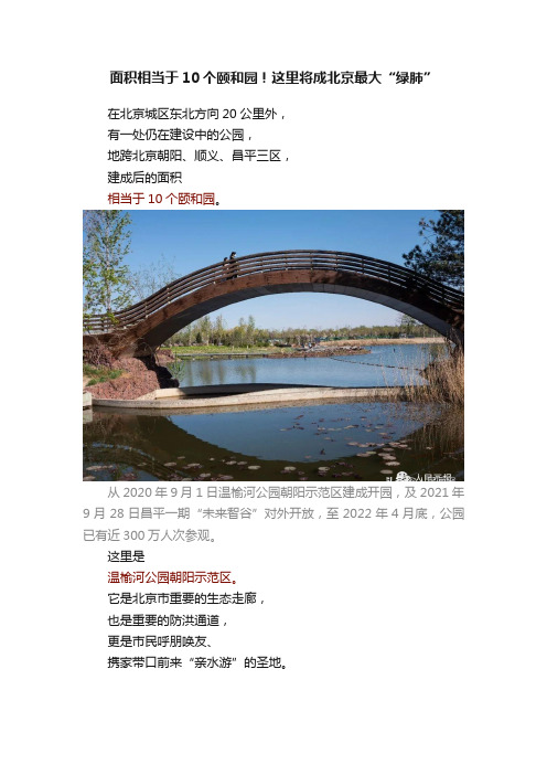
面积相当于10个颐和园!这里将成北京最大“绿肺”在北京城区东北方向20公里外,有一处仍在建设中的公园,地跨北京朝阳、顺义、昌平三区,建成后的面积相当于10个颐和园。
从2020年9月1日温榆河公园朝阳示范区建成开园,及2021年9月28日昌平一期“未来智谷”对外开放,至2022年4月底,公园已有近300万人次参观。
这里是温榆河公园朝阳示范区。
它是北京市重要的生态走廊,也是重要的防洪通道,更是市民呼朋唤友、携家带口前来“亲水游”的圣地。
温榆河公园朝阳示范区通过一条生态水脉构建出亲水宜人的滨水综合体,成为市民休息游玩的好去处。
温榆河,发源于北京北部的军都山,是北京五大水系之中唯一发源于境内的河流,其干流绵延46.4公里,流经昌平、朝阳、通州等多个地区。
温榆河的开发利用最早可追溯至汉代,直至晚清同治年间。
作为京城东北重要的漕运通道,温榆河对京北政治、经济发挥过重要作用。
作为京城东北重要的漕运通道,温榆河对京北政治、经济发挥过重要作用。
其中,地处北京朝阳、昌平和顺义三区交界处的孙河,一直是温榆河上著名的古渡口。
千余年来,随着河流的流淌和淘洗,温榆河不仅带来了滋润万物的流水,也带来了优质的沉沙,许多砂石料厂、搅拌站等砂石产业逐渐在此聚集。
但长期以来的洗沙、炼沙,不仅十分影响周围居民的生产与生活,更严重制约了生态环境的可持续发展。
2014年,孙河乡开始逐步关闭砂石场,并对土地进行清理。
同时,朝阳区开始了科学的生态治理新实践——修建城市绿色公园。
2016年初,700亩公园雏形建成,完成树木种植7.5万株。
曾经的“风沙村落”摇身一变,成为了现在的“城市绿洲”,温榆河公园由此诞生。
温榆河公园内,植被郁郁葱葱。
以水为脉的温榆河公园,延续了近自然生态修复理念,运用“水绿共治”的设计理念,打造出滨水空间。
同时,最大限度保留了原有健康的植被群落、景观地貌,对市民的休闲娱乐、城市蓄洪防洪、加强生物多样性保护都发挥了重要作用。
- 1、下载文档前请自行甄别文档内容的完整性,平台不提供额外的编辑、内容补充、找答案等附加服务。
- 2、"仅部分预览"的文档,不可在线预览部分如存在完整性等问题,可反馈申请退款(可完整预览的文档不适用该条件!)。
- 3、如文档侵犯您的权益,请联系客服反馈,我们会尽快为您处理(人工客服工作时间:9:00-18:30)。
在机场第一通道以东、规划一路两侧是农业旅游业小镇。面积2.02km2,可容纳1.6万人。这个镇主要功能是居住,住宅以多层建筑为主,主要安置拆迁的居民。建筑风格具有传统特色,在镇内形成一些有古镇风情的小街,镇中心是商业街。这里的居民主要从事农业生产以及手工艺品的加工。住宅一般是前店后住,旅游贸易业也很兴旺。
2.2.2乡———乡村景观(歌)
马泉营西路以西,京密路以东的部分为“乡”(乡村景观)区域,主要功能是居住和农业。这是一种住宅和农田交织的新型居住形态,住宅附近就是大面积的现代农庄。这个区域里有3大集中的居住组团,住宅发展也是以低密度高标准社区为主,它们之间有大的湖面可以共享,湖水引自温榆河水系。低密度的住宅区与大片的农田交织在一起,田野可以是大的现代农庄。新的居住发展补充现有的村庄氛围,从而创造一种新的居住形式———乡。人们走出家门,信步走过舒缓的田野,看到青青的麦田,体会闲适的乡村生活,这一切就像一曲乡村牧歌一样令人陶醉。
4条快速路(京承高速、京密路、机场高速、机场第一通道)将生态走廊分成5个风格各异的功能组团,分别形成岛、乡、埠、林、田5种景观特色,它们将承担居住、商贸、游憩、农耕、体育等综合功能,给人们带来或诗、或歌、或画、或梦、或情等不同的心理感受。
2.2.1岛———湿地景观(诗)
温榆河生态走廊里,自马泉营西路以东是“岛”(湿地景观)区域,主要功能为居住、休闲农业和观光旅游。水系在这个区域形成一个自循环的系统。居住约占该区域1/4的面积,以高档低密度社区为主,社区周围环以湿地水系。农田约占1/3的面积,余下部分为开放的湿地旅游区。
3.2 绿化规划
(1)尽量保留现有场地的原生植被,尽量使用北京的乡土树种。
(2)沿温榆河边缘,规划最小宽度100m的防护林带,形成自然边缘。这条林带连接高速路和快速路两侧的交通防护林带,形成林带体系,它仿佛绿楔伸入城市,形成了连接温榆河与城市的绿色通廊。
(3)沿温榆河种种植形态。如“岛”区域内以湿地系统为基础,布置水生林和湿地植物群;在“乡”区域形成了农田和林带相互穿插的形态;在“埠”区域形成庭院式的种植形态。
(3)由于城市快速干道穿过区域而造成生态廊道的断裂,因此规划在交通干道与生物廊道的交叉点设置生态立交点,以保证生物迁移通廊的通达性。
方案中保留了现状的千顷良田,作为现代农庄景观区。横平竖直的道路网展现出“阡陌交通”的壮观景象,现代机械化的农业生产方式将在这里使用。保留现有的水塘,作为螃蟹等水生动物养殖区,将来可以在这里举行“捉蟹节”等农业观光项目。并且,在原有村落的基础上建造农庄建筑和体育设施,把这片区域变成北京观光农业和体育休闲的示范田。
生态———作为永久的主题,是规划要考虑的首要因素
景观———景观视野里的生态规划,将会构筑一道新的风景
北京———未来的世界城市,全球环境的概念应当加以强调
1 现状分析
在温榆河生态走廊45km2的范围内,如下一些特征对于规划方案有较大影响:
(1)场地东侧温榆河与清河交汇处密布鱼塘、水池,形成天然湿地;场地西侧的现状鱼塘区历史上曾是自然湿地;老河湾地带环境条件良好。可以利用这些现状的湿地和水系开辟新的水系统。
按照区域城市的观点,在110km2的范围内,整体考虑产业和空间布局。在温榆河生态走廊以外的65km2范围内,规划了4个各具特色的小镇,分别承担区域内的不同功能。
2.1.2 生态战略———道法自然
用可持续发展的眼光来看,我们自身所居住的地球并非属于我们,它仅仅是我们从子孙后代那里暂时借过来的。我们将把什么样的地球还给下一代?这是规划师和建设者必须要直面的问题。在温榆河生态走廊的规划建设中,首要的问题是如何营建一处让人类眷恋的“绿色环境”。因此,道法自然,“水-绿-人”三位一体的生态设计理念将贯穿我们方案的全过程。
2.3.3家政服务小镇
在长店村北路东侧、温榆河大道南侧是家政服务小镇。面积2.04km2,可容纳1.6万人。这个区域主要是居住和综合社区设施用地。镇中心有国际学校和医院,镇内有各种家政服务公司和园林绿化大队,可以为周边的社区提供现代的家政服务。同时为搬迁过来的农业居民提供非农就业的机会。镇内的住宅发展以多层居住建筑为主,密度相对较高。家政服务小镇的景观建筑风格是综合型的,多种风格可以在统一的基调下并存。
2.2.3埠———船坞景观(画)
在京密路和机场高速路之间,是“埠”(船坞景观)区域,以商业娱乐功能为主,区域内保留了一块现状的别墅区。在这里,按照“温榆水经”等资料的记载以及清明上河图提供的城市生活画面,规划恢复了一个滨水小镇。小镇跨越河的两岸,有桥相连。这是温榆河生态走廊的中心区,也是公共活动最为密集的区域。小镇里面酒楼、饭馆、商铺、茶楼等建筑林立,还有酒吧和歌厅等休闲娱乐场所。无论白天还是夜晚,小镇都具有很高的人气,热闹非凡。这里的建筑尺度都不大,布局形式灵活自然———虽然经过规划,却仿佛自发形成的一样,有着自己内在的秩序。
2.3 特色小镇
我们在65km2的扩大研究范围内,规划了4个功能和风格各异的小镇,小镇之间是广阔的农田和绿地。自东向西依次是高科技产业小镇、商业贸易小镇、家政服务小镇、农业旅游业小镇。
2.3.1高科技产业小镇
在京承高速公路和来广营北路之间是高科技产业小镇,面积2.33km2,可容纳1.8万人。在这个区域内安排高科技产业群和居住用地。这个区域的环境可以延续“岛”即湿地景观的环境特点,营造一种绿色生态环境,以此来吸引国内外著名的高科技企业入驻园区。小镇的中部是康体健身设施和会展中心等交流场所。
3 生态环境
3.1 水系规划
景观规划特别强调对于水系的处理,在原有温榆河水系基础上加以整理,并重新开辟了一条和温榆河平行的新水系。对原有河床进行景观处理,形成河床公园,结合人的游览活动,作为景观展示区域。
温榆河区域水系规划的原则与做法:
(1)保留现有河道与河堤,河道边坡与河流不作衬砌。
一座优美的拱桥横跨河的两岸,犹如彩虹卧波,它跟清明上河图中的桥具有同样的名字———“虹桥”。人们可以在桥上看两岸川流不息的人群,也可以看水面上舟楫如梭,尽情体味盛世繁华———当然自己也在不知不觉中成为了桥上的风景。
2.2.4林———林地景观(梦)
机场高速公路和机场第一通道之间,是“林”(林地景观)区域,以居住和旅游观光功能为主。这里是过去的老河湾地带,历史文化氛围浓郁,保留有很好的古树和树林,规划对其进行补植,形成森林景观。我们对老河湾的水系稍加梳理,形成更多的河道,在河道和密林之间,规划居住建筑群。这里的住宅建筑采取尽端路布局方式,住宅与密林交融,形成童话般幽静而又神秘的意境。沿老河湾规划公共区域,老河湾与温榆河的交汇点形成较大的公园。人们可以沿老河湾游玩,在这条连贯的公共空间里面,按照历史传说设置不同的景点,将历史传说与美丽的风景融为一体。
(4)根据生物演替的规律,合理配置速生树种和优势树种的比例。在近期形成速生树种如毛白杨、垂柳、旱柳、白蜡、臭椿、泡桐等组成的防护林带,在远期形成以优势树种如银杏、刺槐、胡桃、油松等为主体,物种多样的稳定的生态走廊。
3.3 生态规划
(1)设置有机驳岸。所有的河岸与河底不做硬质衬砌。
(2)以草坡入水,加以水生植物及垂柳、水杉等耐涝树木护岸。
(2)黄港乡和楼梓庄是现状农田密集区,对于现有的良田应该考虑保留。
(3)现有河流环境污染严重,河流生态系统退化,自净能力丧失;河流功能简单化甚至丧失;自然地貌改变带来水文特征恶化。现状沟渠较多,应加以妥善利用。
(4)现状居民以农业生产为主要产业,远期考虑整体搬迁出生态走廊,因此,这部分人的就业问题应充分加以考虑。
(2)在生态走廊的西端开辟新的人工湿地,以增加区域的蓄洪能力,同时跟原有的自然湿地一起形成丰富的湿地景观。
(3)开渠引水。在局部区域,开挖新的水渠,引温榆河水进入各居住组团,或者在节点处形成湖面,以增加人们的亲水面。同时,新的水系也可以增加蓄洪和调节小气候的作用。
(4)改造排水渠。现状温榆河区域内沟渠密布,纵横交错,乡村级的排水渠近50条,对区域内的水系统和景观有着较大的影响。在结合现场实地考察的基础上,规划对排水渠提出新的构想,即在保留现状排水体系以满足防洪排水的需求这一前提下,适当改造排水渠,使之成为防洪、排水、生物净化、景观、娱乐等多功能的综合水系。
2.1.4产业战略———链状结构
温榆河区域的产业发展要解决两方面的问题:一是当地农业居民的搬迁安置,要妥善解决这部分人的就业问题;二是要引进新的产业类型,振兴地方经济。我们提出产业链的概念,旨在形成一条跟生态走廊平行的相关产业走廊。
2.2 五种景观
温榆河生态区域的景观规划原则是“以水为轴,以绿为体,以人为本”。
2 方案创意及特点
2.1 四大战略
2.1.1 功能战略———区域整合
我们从区域着眼来把握温榆河生态走廊的整体规划。“区域城市”(regional city)由若干社区(community)组成,每个社区都具有支持现代经济生活和城市基本设施的规模。每个社区除了居住的功能之外,还可具备一至几项为这个组群服务的专门职能———工业和商业,文化和教育,金融和行政,娱乐和休养。社区的四周由自然绿带环绕,既保持良好的环境,又控制社区向外蔓延。各社区之间的开放空间将永久保存,只用于农业、林业和休憩。便捷的公路系统四通八达,并与不穿越城镇的高速公路相连,交通十分方便。
温榆河生态走廊的东侧,现有的密集的河道、鱼塘、水池构成了独特的自然湿地景观。为了阻止人类经济活动对于湿地生态功能的负面影响,惟有用湿地恢复与重建的生态工程,为湿地的存在与自然演替施加积极主动的正面干预,才能充分发挥湿地的生态价值。因此,方案在生态走廊东侧区域内恢复原有的自然湿地,并营建大量的人工湿地,形成湿地区域。在这个区域内安排岛状的高标准住宅用地,这些岛的周围是连续的、枝状的湿地系统。这里生长着荷花、芦苇等丰富的湿地植物,还有各种各样的鱼类和候鸟,形成一种“雁声芦叶老,鹭影蓼花寒”的美学意境。