天津津南区总体城市设计2
天津市津南区人民政府关于印发津南区“四好农村路”全国示范县创建工作方案的通知

天津市津南区人民政府关于印发津南区“四好农村路”全国示范县创建工作方案的通知文章属性•【制定机关】天津市津南区人民政府•【公布日期】2023.02.14•【字号】津南政发〔2023〕1号•【施行日期】2023.02.14•【效力等级】地方规范性文件•【时效性】现行有效•【主题分类】村镇建设正文天津市津南区人民政府关于印发津南区“四好农村路”全国示范县创建工作方案的通知津南政发〔2023〕1号各街镇、各委、办、局,各直属单位:《津南区“四好农村路”全国示范县创建工作方案》已经区人民政府同意,现印发给你们,请遵照执行。
附件:津南区“四好农村路”全国示范县创建自查标准及责任单位汇总表2023年2月14日津南区“四好农村路”全国示范县创建工作方案为深入贯彻落实习近平总书记关于“四好农村路”的重要指示精神,按照《“四好农村路”全国示范县创建管理办法》(交公路发〔2022〕111号)、《交通运输部办公厅关于组织开展2022年“四好农村路”全国示范县创建工作的通知》(交办公路函〔2022〕625号)和《交通运输部办公厅农业农村部办公厅国家邮政局办公室国家乡村振兴局综合司关于公布2022年度“四好农村路”全国示范县创建单位名单的通知》(交办公路〔2022〕83号)要求,持续推进“四好农村路”高质量发展,示范引领作用发挥充分,对照创建工作总体要求,结合专家评审意见,优化创建目标,细化工作计划,明确责任分工,强化保障措施,并根据此前制定的创建方案完善制定优化方案如下:一、指导思想以习近平新时代中国特色社会主义思想为指导,认真贯彻落实党的二十大精神,深入贯彻习近平总书记关于“四好农村路”的重要指示精神和党中央、国务院决策部署,践行以人民为中心的发展思想,按照立足新发展阶段、贯彻新发展理念、构建新发展格局的要求。
推动“四好农村路”示范创建从区域示范引领向全域达标发展转变,建设人民满意交通,加快建设交通强市与乡村振兴有效衔接,加快农业农村现代化提供保障。
双港-李楼修详规说明
天津市津南区双港镇河畔星城安置区修建性详细规划说明书一、规划背景继党中央、国务院于1980年至1982年三个“一号文件”将农村问题列为全国重点问题后,2005和2006年的两个“一号文件”又将“三农”问题及社会主义新农村建设问题作为了全国的重点问题,并提出了“生产发展、生活富裕、乡风文明、村容整洁、管理民主”的二十字方针。
建设社会主义新农村、统筹城乡发展是坚持科学发展观、树立以人为本的思想、构建和谐社会的重要途径。
2006年7月27日,国务院正式批复《天津市城市总体规划(2005-2020年)》,确立了天津作为国际港口城市、中国北方经济中心和生态城市的城市性质与定位。
在党的十六届五中全会和十届全国人大四次会议中,推进滨海新区的开发开放也被纳入了国家总体发展战略,同时在今年国务院“20号文件”中,滨海新区又被定位为“综合配套改革试验区”。
在全国地位的提升意味着天津将面临跨越式新发展的重要历史机遇。
因此,尽快实施城乡统筹规划,提高土地使用效益,提高农业综合生产能力,稳步推进郊区城镇化,优化城镇空间布局,加快社会主义新农村建设成为当务之急。
天津市在完成了“三镇两村”的新农村规划试点后,积累了宝贵的经验,打破了农村城市化过程中的土地壁垒,同时在塑造城镇特色方面也取得了瞩目的成果。
“9341”战略目标之一的双港中心镇,本次规划在推进农村城镇化和建设社会主义新农村的要求下,充分挖掘地域自然、人文特色,发挥区位、资源优势,整合镇村布局,优化土地资源,加快经济发展,建设宜居家园。
二、规划位置及四至范围双港镇位于海河中下游南岸,东南与辛庄镇接壤,西北与天津市河西区相邻,西至西青区,北靠海河,与东丽区隔海河相望。
距天津中心城区约4公里、距塘沽新港约40公里、距天津滨海国际机场约5公里、距咸水沽约9公里。
本规划区域位于天津市津南区双港镇镇区北部,天津大道和海河之间,其四至范围为:东至规划路,西至外环线500米绿带,北至规划路,南至规划海河南路。
天津市城市总体规划
天津市城市总体规划城市总体规划眼下咱能摸着嘛时间:2006年08月27日08:50 搜索我来说两句【来源:天津日报网-城市快报】2010中心城区建14处商业中心完成滨海国际机场扩建工程高速铁路京津多几条通道中心城区完成四条地铁轻轨建立起快速路骨架路网系统建一批医疗文化体育设施记者吴森/城市快报记者从昨天在国际展览中心举办的《天津市城市总体规划(2005年—2020年)》展上获悉,围绕总体规划,本市规划部门还制定了本市2005年—2010年的近期建设规划,市民对本市近期将重点建设的交通和公共设施更加明了。
公共设施中心城区建设14处区级商业中心建新天津医院扩建精神卫生中心商业设施:中心城区建设14处区级商业中心,其中主要有佟楼、大沽南路、体育中心、水上公园、西站、丁字沽、大直沽、华昌大街、中山门、中山路、新开北路、胜利路、北运河、建设路等商业中心。
文化设施:重点建设海河文化带,建设规划展览馆、音乐厅、博物馆等文化设施。
体育设施:按照建设体育强市的目标和申办2013年第十二届全运会的标准,以建设奥林匹克中心为龙头,以滨海新区为重点,完善及扩建原有的运动场、体育馆、游泳馆、网球场等体育活动场所。
扩建全国一流的蓟县体育训练基地和韩家墅体育训练基地。
医疗卫生设施:新建新天津医院、改扩建精神卫生中心、妇女儿童保健中心、卫生监督所、职业病防治院、儿童医院、医大总医院二期项目、一中心医院器官移植中心、中医一附院医疗综合楼和医大二院二期等重点项目。
绿化建设沿海河构筑东西向生态走廊建立沿海生态型经济防护林中心城区实施绿色家园工程,重点建设侯台、梅江、柳林、南淀、银河五大风景区和植物园、桥园等大型公园。
继续建设外环线绿化带以及沿快速路、铁路(6条)、河流(12条)两侧绿化。
滨海新区结合古海岸自然保护区,构筑南北向的生态绿地,沿海河构筑东西向的生态走廊,建立沿海生态型经济防护林体系。
对外交通完成滨海国际机场扩建工程高速公路通车里程1000公里港口:到2010年,天津港货物吞吐量达到3亿吨,集装箱吞吐量达到1000万吨。
津南区小站镇操场河村、会馆村等五村村庄规划主要指标控制表
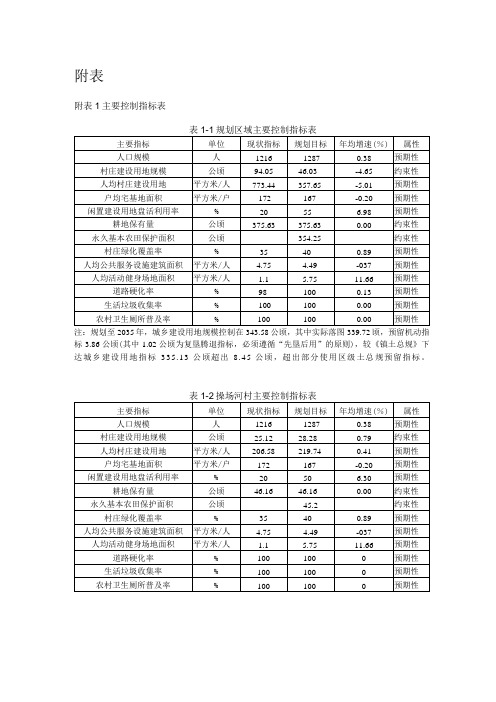
主要指标
单位
现状指标
规划目标
年均增速(%)
属性
人口规模
人
1216
1287
0.38
预期性
村庄建设用地规模
公顷
25.12
28.28
0.79
约束性
人均村庄建设用地
平方米/人
206.58219Biblioteka 740.41预期性
户均宅基地面积
平方米/户
172
167
-0.20
预期性
闲置建设用地盘活利用率
%
20
50
6.30
预期性
耕地保有量
公顷
46.16
46.16
0.00
约束性
永久基本农田保护面积
公顷
45.2
约束性
村庄绿化覆盖率
%
35
40
0.89
预期性
人均公共服务设施建筑面积
平方米/人
4.75
4.49
-037
预期性
人均活动健身场地面积
平方米/人
1.1
5.75
11.66
预期性
道路硬化率
%
100
100
0
预期性
预期性
道路硬化率
%
98
100
0.13
预期性
生活垃圾收集率
%
100
100
0.00
预期性
农村卫生厕所普及率
%
100
100
0.00
预期性
注:规划至2035年,城乡建设用地规模控制在343.58公顷,其中实际落图339.72顷,预留机动指标3.86公顷(其中1.02公顷为复垦腾退指标,必须遵循“先垦后用”的原则),较《镇土总规》下达城乡建设用地指标335.13公顷超出8.45公顷,超出部分使用区级土总规预留指标。
关于津南区总体规划的公示
关于津南区总体规划的公示根据市政府批准的《津南区总体规划纲要(2007-2020年)》,我局和市规划院共同编制完成了《津南区总体规划(2008-2020年)》,该规划在纲要的基础上对我区城镇布局、产业布局、人口规模等进行了适当的调整,并对我区的社会事业、住宅发展、绿化景观、环境保护、基础设施等进行了系统的规划,重点对津南新城的空间结构、公共服务设施、用地规模、产业布局和交通等进行了细化深化,目前已得到市规划局批准。
此次编制的《津南新城总体规划(2008-2020年)》是《津南区总体规划》的重要组成部分;是天津市“11个新城规划”之一;是我区社会、经济和城市化快速发展的主要地区。
随着天津的发展重心从中心城区逐步向外转移,津南区进入了新的发展时期,津南新城实现跨越式发展,在津南区整体发展战略中起到重要作用。
为了使规划更具科学性、合理性,广泛听取社会各界的意见和建议,特将《津南区城市总体规划(2008-2020年)》在2008年10月10日--11月10日期间进行公示,欢迎社会各界人士提出宝贵意见。
一、津南区总体规划规划期限:近期2008年--2011年,远期2012年--2 020年,远景至2050年。
规划范围:本规划设计范围是津南行政辖区。
发展定位:津南区是津滨城市发展主轴上的重要区域,建设成为津滨主轴南翼新兴产业基地;海河中游南岸现代服务业中心;中心城市南部生态宜居宜游城市。
城市职能:连接“津、滨”、依托海河,发展现代服务业,建设高品质的生态宜居城区;对接滨海新区产业,建设以信息产业为主导以及现代冶金和精密制造为辅的产业聚集区;建设体现生态湿地和近代历史文化特色的旅游度假区。
城市发展战略:立足于天津中心城市这一都市区的发展结构,以天津中心城市内部各区域功能协调为前提,以自身发展条件为基础,以实现快速区域化、全面城市化为目标。
根据津南区社会和经济发展进程需要,以区域协调,城乡一体的发展方式面对历史机遇,提出“东进、西连、南生态、北提升”发展战略和“9341”四大奋斗目标,加快城乡一体化进程。
天津津南区总体城市设计
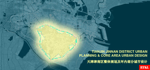
ECO-WETLAND PRESERVE 生态湿地保护公园
A green heart which radiates outwards, the “big green” anchor to Haihe’s “big blue.” The preserve is a place for engagement with natural wildlife and an educational resource for the community. 一个向外辐射的绿色核心,一个与海河蓝绿相呼应的端点。生态湿地保护公园将成为野生动物的乐土 ,市民体验自然的生态教育资源。
Regional Constraints 津南区的发展限制
东丽区目前已形成强势的吸引力,可能分流津南的 人才吸引。 早期建设的主要道路将津南切割成不规则地块。 各个镇区现状已经有较多建设却不能相互协调。 目前的产业园区分布呈现“追路”模式,难以整合。 津南外围还分布有工业区缺乏较好的外围生态氛围
Dongli already has strong attraction for human resource which share part of Jinnan’s potential residents. Early built major roads cut Jinnan district into pieces. Existing construction of each town doesn’t work with each other. Existing industry parks follow the roads, hence hard to be integrated. Most of adjacent area to Jinnan is also industrial use which doesn’t provide Jinnan a good eco scenario.
天津市津南区人民政府关于印发津南区加快数字化发展三年行动方案(2021-2023年)的通知
天津市津南区人民政府关于印发津南区加快数字化发展三年行动方案(2021-2023年)的通知文章属性•【制定机关】天津市津南区人民政府•【公布日期】2021.12.30•【字号】津南政发〔2021〕10号•【施行日期】2021.12.30•【效力等级】地方规范性文件•【时效性】现行有效•【主题分类】城市建设正文天津市津南区人民政府关于印发津南区加快数字化发展三年行动方案(2021-2023年)的通知各街镇,各委、办、局,各直属单位:《津南区加快数字化发展三年行动方案(2021-2023年)》已经区人民政府同意,现印发给你们,请遵照执行。
2021年12月30日津南区加快数字化发展三年行动方案(2021-2023年)为深入贯彻落实习近平总书记关于建设网络强国、数字中国的重要论述,加快我区数字化发展,促进全方位数字化转型升级,根据《天津市加快数字化发展三年行动方案(2021-2023年)》(津政发〔2021〕14号)精神,结合我区实际,制定本方案。
一、总体要求(一)指导思想以习近平新时代中国特色社会主义思想为指导,全面贯彻党的十九大和十九届二中、三中、四中、五中、六中全会精神,深入贯彻落实习近平总书记对天津工作“三个着力”重要要求和一系列重要指示批示精神,立足新发展阶段、贯彻新发展理念、构建新发展格局,聚焦数字时代城市高质量发展,围绕数字化既深度融合产业又成为人民群众不可或缺、无所不在的生活方式,以场景牵引和数字赋能为主线,加强顶层设计和统筹谋划,按照“3+1+4”发展思路,推进数字经济、数字社会、数字政府三大领域协同发展,打造城市大脑,健全完善新型基础设施建设、强化数字科技创新攻关、探索建立数据要素市场、营造良好数字生态四位一体保障体系,全面建设数字津南,助力绿色生态示范区、创新发展聚集区、会展经济功能区和“双碳”工作先行示范区建设。
(二)基本原则——注重谋划、加强统筹。
树立系统思维、全局观念,坚持集约共享,充分发挥政府统筹协调和规范引导作用,推动数字时代城市生产方式系统变革、生活方式多维变迁、治理方式演进升级。
天津市津南区土地利用总体规划

第一节
一、区域发展定位
津南区位于天津中心城区和滨海新区城市发展主轴上,是海河中游南岸的重要城市。要建设成为高端产业聚集区和生态宜居区,打造功能完善、富有活力、可持续发展的综合型辅城。
5、地质构造
地质构造具体表现为岩石的褶皱、断裂、纹理以及面状、线状构造。对水工建物筑地基的稳定性和渗漏性有直接影响。第五代区划图《中国地震动参数区划图》(GB18306-2015)已于2016年6月1日正式实施,将津南区北部地区抗震设防烈度修订为Ⅷ度,因此位于津南北部的咸水沽镇、葛沽镇、双港镇、莘庄镇及双桥河镇的抗震设防烈度为Ⅷ度。
——高端服务业聚集区。在海河中游规划建设一批功能突出、规模领先、辐射能力强的现代服务业片区,大力发展总部、金融、金融、金融、会展、创意、设计等业态,提升产业综合服务功能,使津南成为面向京津冀、服务雄安新区和滨海新区的区域性产业服务中心。
7、《中华人民共和国自然保护区条例》;
8、《天津市永久性生态保护区域管理规划》;
9、《天津市湿地保护条例》(2016年);
10、《中华人民共和国自然保护区条例》(1994年发布、2011年、2017年修订);
11、《县级土地利用总体规划编制规程》(TD/T 1024-2010);
12、《县级土地利用总体规划制图规范》(TD/T1021-2010);
打造“两基地两区”的产业发展格局。
——产学研用创新示范基地。发挥科教人才资源集聚优势,加快高研园建设,构建产学研用协同创新体系,形成科研成果转化示范效应,打造服务京津冀创新协同发展标杆区。
——京津先进制造基地。坚持高端发展,不断完善产业链,做强做优新一代信息技术、高端装备等产业,推动生物医药、新材料、汽车等产业规模化发展,形成若干个具有全国影响力的产业集群和一批具有国际争力的知名品牌。
天津市总体规划

旅游业。
第五部分 城镇体系规划
《规划》以实现城乡和区域的统筹发展为目标,根据天津城镇人口和 城镇发展的特征,在“一轴两带三区”空间布局结构的基础上,明确提 出以中心城区和滨海新区核心区为主副中心,建立由主副中心、新城、 中心镇和一般建制镇组成的四级城镇体系,按照循序渐进,节约用地, 集约发展,合理布局的原则,因地制宜地稳步推进城镇化,逐步改变城 乡二元结构,提高城镇化水平。
城市性质和规模
滨海新区包括塘沽、汉沽、大港三个行政区和天津经济技术开发区、天津 港保税区、天津港区以及东丽区、津南区的部分区域,陆域总面积约为2270平 方公里,地理位置优越,自然资源丰富,科技人才密集,产业基础雄厚,交通
滨海新区 通讯便捷,综合优势明显,在我市城市发展过程中始终占有重要地位。特别是
滨海新区的金融、商务聚集地。重点发展以银行、保险类业务为主的金融服务业,以商贸流通、现
代物流为主的商务服务业,以广告、音乐创作和新媒体为主的创意➢
河北区定位为“创意河北”:建设成为我市创意产业聚集区、文化休闲旅游基地和市区北部商
务商贸聚集地。重点发展以产品、工程动漫设计和会展策划为主的创意产业,以电子商务、现代物
➢ 总体规划》明确,以滨海新区核心区为中心,汉沽新城和大港新城为两翼
的组团式布局结构,依托京津塘高新技术产业带、天津港等,重点建设先 进制造业产业区、滨海高新技术产业区、中心商务商业区、滨海化工区、 海港物流区、临空产业区、海滨休闲旅游区等七个产业功能区,此外,结 合建港造陆,科学论证,规划建设临港产业区;各城区与组团间用生态保 护区和生态廊道隔离,构建宜居的生态环境;加强基础设施建设,结合市 域对外交通体系,构筑滨海新区“十横六纵”骨架路网,形成滨海新区与 中心城区及周边地区方便快捷的交通联系,努力把滨海新区建设成世界先 进的开放型、创新型、多功能型现代化的经济新区、社会新区、生态新区 和综合改革试验区。通过改革开放、科技创新、产业集聚、功能辐射,逐 步实现滨海新区的定位,推进体制机制创新,提升整体技术水平和综合生 产力,提高单位面积的投资强度和产出效率,实现人与自然、经济社会与 生态环境和谐发展,增强区域服务功能,更好地带动天津发展,服务和带 动环渤海乃至全国经济社会发展。
天津市城市管理委员会关于柳林公园二期工程初步设计的批复
天津市城市管理委员会关于柳林公园二期工程初步设计的批复文章属性•【制定机关】天津市城市管理委员会•【公布日期】2022.12.26•【字号】津城管绿〔2022〕244号•【施行日期】2022.12.26•【效力等级】地方规范性文件•【时效性】现行有效•【主题分类】城市管理正文天津市城市管理委员会关于柳林公园二期工程初步设计的批复津城管绿〔2022〕244号天津设计之都城市发展有限公司:你司《关于呈请审批柳林公园二期工程初步设计的请示》(天津设计之都综发〔2022〕59号)收悉。
经研究,现批复如下:一、根据《天津市政府投资管理条例》(津人发〔2019〕33号),原则同意你司组织编制工程初步设计。
二、主要建设内容及规模柳林公园二期工程选址位于天津市海河柳林地区津南区04-02、05-33、05-36地块,用地四至:北临海河,东临南兴道,南至国盛道,西至华兆路、柳林公园一期,台儿庄南路横穿项目而过,占地面积约79.10公顷。
项目主要建设内容包括土方工程、景观工程、绿化种植工程、智慧工程、配套建筑工程等。
1.土方工程:总挖方量约240442.9立方米(场地平整挖方量),回填方量约348164,32立方米。
2.景观工程:实施停车场专项工程、铺装工程、景观家具设施、无障碍工程、电气设备安装工程、给排水工程、结构工程等内容。
3.绿化种植工程:实施绿化面积558745.35平方米,其中:新种植植物乔木约1.16万株,独本灌木约0.52万株,灌木丛约7.94万平方米,地被植物约47.43万平方米,水生植物约0.8万平方米。
4.智慧工程:分为硬件和软件两部分,其中:硬件部分包括公园运营指挥中心、各类互动体验设备和配套监管设备,以及生态科技馆室内展陈设备等;软件部分包括智慧公园驾驶舱、游客服务系统、日常管理系统、安全应急系统、运营管理系统等。
5.配套建筑工程:建筑总占地面积14284.75平方米,共由13个单体组成,其中:配套服务设施一级驿站6处、二级驿站7处(具体为贝壳活动馆,风尚运动馆,文化展馆,阅水厅,雅舍厅,码头游客服务中心,1~7#公厕+小卖部)。
天津市城市总体规划
天津市城市总体规划城市总体规划眼下咱能摸着嘛So a缨谤时间:2006年08月27日08:50搜索我来说两句【来源:天津日报网-城市快报】2010中心城区建14处商业中心完成滨海国际机场扩建工程高速铁路京津多儿条通道中心城区完成四条地铁轻轨建立起快速路骨架路网系统建一批医疗文化体育设施记者吴森/城市快报记者从昨天在国际展览中心举办的《天津市城市总体规划(2003年一2020 年)》展上获悉,围绕总体规划,本市规划部门还制定了本市2005年一2010年的近期建设规划,市民对本市近期将重点建设的交通和公共设施更加明了。
公共设施中心城区建设14处区级商业中心建新天津医院扩建精神卫生中心商业设施:中心城区建设14处区级商业中心,其中主要有佟楼、大沽南路、体育中心、水上公园、西站、丁字沽、大直沽、华昌大街、中山门、中山路、新开北路、胜利路、北运河、建设路等商业中心。
文化设施:重点建设海河文化带,建设规划展览馆、音乐厅、博物馆等文化设施。
体育设施:按照建设体育强市的LI标和申办2013年第十二届全运会的标准,以建设奥林匹克中心为龙头,以滨海新区为重点,完善及扩建原有的运动场、体育馆、游泳馆、网球场等体育活动场所。
扩建全国一流的蓟县体育训练基地和韩家墅体育训练基地。
医疗卫生设施:新建新天津医院、改扩建精神卫生中心、妇女儿童保健中心、卫生监督所、职业病防治院、儿童医院、医大总医院二期项II、一中心医院器官移植中心、中医一附院医疗综合楼和医大二院二期等重点项U。
绿化建设沿海河构筑东西向生态走廊建立沿海生态型经济防护林中心城区实施绿色家园工程,重点建设侯台、梅江、柳林、南淀、银河五大风景区和植物园、桥园等大型公园。
继续建设外环线绿化带以及沿快速路、铁路(6 条)、河流(12条)两侧绿化。
滨海新区结合古海岸自然保护区,构筑南北向的生态绿地,沿海河构筑东西向的生态走廊,建立沿海生态型经济防护林体系。
对外交通完成滨海国际机场扩建匸程高速公路通车里程1000公里港口:到2010年,天津港货物乔吐量达到3亿吨,集装箱呑吐量达到1000万吨。
天津津南规划

交通网络牵动万众瞩目
亮点之“天津大道” 亮点之“天津大道”
日前,备受瞩目、全长37公里的天津 大道快速公路开始施工建设。天津大道 连接中心城区小白楼中心商务区与滨海 新区于家堡、响螺湾中心商务区,是海 河南岸唯一一条快速通道。天津大道沿 线经过津南区双港镇、辛庄镇、咸水沽 镇、双桥河镇、葛沽镇和塘沽区新城镇 及滨海新区中心商业商务区。工程起点 为外环线津沽立交,终点为中央大道, 全长36.745公里;其中津南区段全长 25.156公里,塘沽区段全长11.589公里。 天津大道的开工建设对于新津南城 区发展起到了积极的促进作用,更为津 南区成为连接城市中心与滨海新区的黄 金走廊奠定了稳固的基础。
天津津南规划
2009年天津南部亮点频出 年天津南部亮点频出 津南提速 海河经济蕴含巨大商机 无缝连接 市中心与滨海黄金走廊
华北地区超大规模水城浮出水面
星耀五洲重生态“领舞” 星耀五洲重生态“领舞”人居福地
天津星耀投资有限公司策划总监黄俊表示,临水而居是人们一直 以来的居住理想,在缺水的北方,水域面积和杭州西湖一样大的天嘉 湖,犹如一块翡翠,是一个珍贵而稀缺的生态资源,更是物业升值保 值的重要潜质。2007年,望西湖的高层公寓售价达到12万元一平方 米,是杭州市区住房均价的4倍,最终还是销售一空,湖泊带来的人 居价值由此可见一斑,如果这个湖泊距离城市较近,其周边物业的价 值更是难以估量。目前,天嘉湖板块已经成为整个天津的聚焦点,而 星耀集团投资200亿元,打造的11000亩世界岛水上浮城——星耀五 洲,更为天嘉湖变身“北方西湖”之路提供了强大动力。 据了解,星耀五洲保留了7000多亩的水面,在这和西湖一样大的 水域面积之上,将世界版图适当调整后同比例微缩,形成地理意义上 的五大洲,环湖建设12公里长的景观运动公园,近距离接驳京津城际 轨道交通系统。在偌大的土地资源中拥有世界的版图,这不能不说是 一个具有创造性、前瞻性的大手笔。 道路路网建设的不断完善为津南区的发展注入了鲜活的养分。津 南新城充分利用连接市中心城区和滨海新区的地缘优势,做到新城建 设与海河综合开发建设有机贯通、融为一体。
天津市空间发展双城双港战略整体规划(doc 25页)

天津市空间发展双城双港战略整体规划(doc 25页)部门: xxx时间: xxx整理范文,仅供参考,可下载自行编辑天津市空间发展"双城双港"战略规划征求民意总体战略示意图双城双港、相向拓展、一轴两带、南北生态总体战略示意图双城双港< !--splitnewspage-->总体战略示意图相向拓展!--splitnewspage-->滨海新区发展策略示意图一核!--splitnewspage-->中心城区发展策略示意图一主两副沿河拓展!--splitnewspage-->天津市文化中心总平面图!--splitnewspage-->2006年7月,国务院批复《天津市城市总体规划(2005-2020年)》。
该规划进一步调整提升了天津的城市定位,拓展了城市发展空间,在促进全市经济社会发展和指导城市建设等方面发挥了重要作用。
为进一步深化实施天津市城市总体规划,根据市委、市政府的决策部署,自去年5月开始,组织开展了《天津市空间发展战略规划》(以下简称空间发展战略规划)的编制工作。
空间发展战略规划坚持以邓小平理论和“三个代表”重要思想为指导,深入贯彻落实科学发展观,按照胡锦涛总书记对天津工作“两个走在全国前列”、“一个排头兵”的重要要求,紧紧围绕国家对天津的城市定位和加快推进滨海新区开发开放战略,按照市委“一二三四五六”的奋斗目标和工作思路,用科学的理念和方法,对城市发展方向、空间布局结构等重大问题作出展望和安排。
按照高起点规划的要求,我们邀请中国城市规划设计研究院和天津市城市规划设计研究院等高水平设计单位组成联合设计团队共同承担规划编制工作,相继开展了港口集疏运、盐田利用等多项专题研究,并邀请规划、交通、经济、社会、生态等方面的专家学者进行了反复研讨和论证。
市主要领导同志高度重视,先后十几次现场办公,听取汇报,深入讨论研究。
市委常委扩大会议、市政府常务会议对空间发展战略规划进行了审议。
津南区人民政府关于印发津南区落实京津冀协同发展天津市规划纲要工作方案的通知-津南政人〔2015〕8号

津南区人民政府关于印发津南区落实京津冀协同发展天津市规划纲要工作方案的通知正文:---------------------------------------------------------------------------------------------------------------------------------------------------- 津南区人民政府关于印发津南区落实京津冀协同发展天津市规划纲要工作方案的通知津南政发〔2015〕8号各镇人民政府,各委、办、局,各直属单位:《津南区落实京津冀协同发展天津市规划纲要工作方案》已经区人民政府同意,现印发给你们,请认真遵照执行。
2015年6月19日津南区落实京津冀协同发展天津市规划纲要工作方案京津冀协同发展是新时期重大国家战略,是一项复杂、艰巨、繁重的系统性工程。
目前,京津冀协同发展已从总体谋划为主向加快编制规划和大力推进实施相结合的新阶段迈进,疏解非首都功能的任务更加突出,为进一步做好我区引进非首都功能项目的承接工作,使我区成为京津冀协同发展的重点承载地,特制定本工作方案。
一、工作目标紧紧围绕天津市关于京津冀协同发展的总体规划和承接北京非首都核心功能的部署安排,依托我区“双城双港相向拓展”发展主轴中心地带的区位优势,把京津冀协同发展作为带动我区新一轮开发开放的重大机遇,深化顶层设计,加强谋划创新,狠抓推动落实。
按照我区“一二三四五”的工作目标和要求,结合招商引资年活动,进一步加大招商引资力度,积极承接首都功能疏解,吸引更多大项目好项目落地,着力提升我区经济综合实力,推动产业转型升级。
二、工作任务(一)落实顶层设计做好前期规划抢抓海河中游职教会展区列入天津市推进京津冀协同发展“1+11”格局产业对接合作平台的机遇,向市委、市政府建议尽快启动“津南区海河中游开发规划”的编制工作,积极协调市有关部门争取将津南区海河中游开发列入天津市“十三五”规划和京津冀协同发展规划,争取将该片区作为我市京津冀协同发展的重要载体;充分发挥海河教育园区的支点作用,尽快编制海河教育园区高研园规划,加强与海河教育园区的协调、合作,促进产学研融合发展;加快推动交通基础设施建设,协调市有关部门做好轨道交通项目建设的前期工作。
- 1、下载文档前请自行甄别文档内容的完整性,平台不提供额外的编辑、内容补充、找答案等附加服务。
- 2、"仅部分预览"的文档,不可在线预览部分如存在完整性等问题,可反馈申请退款(可完整预览的文档不适用该条件!)。
- 3、如文档侵犯您的权益,请联系客服反馈,我们会尽快为您处理(人工客服工作时间:9:00-18:30)。
Dongli Lake Tianjin, China 中国天津,东丽湖区域
环内部分发展限制 CORE AREA CONSTRAINTS
环内部分发展机遇
CORE AREA OPPORTUNITIES
环内部分设计过程——绿网
CORE AREA - PROCESS GREEN NETWORK
Create green linkages to break down districts together 创造绿化走廊分隔合理的社区尺度
环内部分——规划步行系统
CORE AREA - PROPOSED PEDESTRIAN SYSTEM
环内部分——规划公共交通系统
CORE AREA - PROPOSED PUBLIC TRANSPORTATION
Transportation stations act as anchoring devices. We must look at transport systems and how they feed people into the district and at what point. Whether it is at grade, below grade, above grade through bridges and linkages, the more transport systems can feed the development the more successful and enduring it will become. Within the inner ring core-area, the light rail station is anchored towards Tianjin Boulevard and the Ring road. Therefore, it is essential to design an efficient and well-integrated public bus system that will link to this masstransit opportunity and to other systems, making them available to the convenience of the community. An 8 to 10 minute walking radius to a public system is seen as the ideal scenario for the core-area. 交通站点可以视为吸引人流的节点。公共交通系统和站点的设 计必须考虑服务社区的位置和路线。无论是地面、地下或是桥 梁等的联系,公交系统服务越高效和全面,地区的开发才会越 成功和持久。在该津南区环内部分区域,地铁站是将人流和车 流从天津大道和外环路分流和聚集的重要节点。因此,公交系 统的设计必须要系统而高效,与地铁站和其它社区紧密联系, 方便人们的出行和各项活动。8至10分钟的步行距离圈是该地区 公交站点合理的分布距离。
TOWN/NEIGHBORHOOD CENTERS
市镇与邻里服务中心
The current form of the inner-ring site has a very linear identity. We want to create appropriately scaled and distanced town/neighborhood centers that service the needs of the community; while also helping to establish different neighborhood identities, aesthetically and formally. 环内部分现状的公共服务商业及服务设施分布过于线性。我们想要创造规模适当的、距离适中的 市镇与邻里社区服务中心,为社区日常生活所需服务,同时由此从区域和认知角度界定社区的组 团特性。
环内部分设计过程——核心
CORE AREA - PROCESS CENTERS
Create unique centers within each district. 在社区内部创造集聚的中心
环内部分设计过程——中央绿轴
CORE AREA - PROCESS CENTRAL GREEN SPINE
环内部分设计过程——水系
CORE AREA - PROCESS WATERWAYS
Create a interconnected waterway system that provides natural amenities to people and ties back to Haihe. 创造整合的水系连接海河,为人们提供自 然休憩空间
原规划土地利用 CONSTRAINED SITES OF DEVELOPMENT
环内部分——尺度对比
CORE AREA SCALE COMPARISONS
Suzhou Riverfront Area Shanghai, China 中国上海,苏州河地区
Along the Mississippi Riverfront New Orleans, USA 美国新奥尔林,密西西比河滨水区
Hale Waihona Puke 主要道路功能 MAJOR ROAD FUNTION
区域联系 REGIONAL CONNECTION
原规划土地利用 EXISTING REGULATORY LAND-USE
原规划路网 EXISTING CIRCULATION
原规划土地利用 EXISTING REGULATORY LAND-USE
环内部分——规划路网结构图
CORE AREA - PROPOSED VEHICULAR NETWORK
环内部分——开发强度分布图
CORE AREA - PROPOSED FAR。
环内部分——边界构控制图
CORE AREA - PROPOSED EDGE CONDITION
环内部分——道路剖面
土地的综合利用和密度的适当分布 津南区环内部分以住宅用地为主,布置综合利用功能(社区服务中 心、中小学幼托、公共设施等)能够提升社区的活力和凝聚力,并 满足社区发展和走向成熟的所需。这些重要的功能都位于交通方便、 可达性良好的位置,为满足适当的住宅密度和步行距离的要求形成 数个小型社区中心。 对于津南区环内部分来说,1.3到1.4是比较合适的开发密度,最大 化利用以交通为导向的发展模式的优势,减少私车用量,鼓励使用 公共交通工具,使该区得到繁荣的发展。
环内部分——市域区位
市中心 <- 门户-> 津南
CORE AREA – METROPOLITAN POSITION DOWNTOWN <- GATEWAY -> JINNAN
环内部分——市域区位
区域影响因素
CORE AREA – METROPOLITAN POSITION REGIONAL INFLUENCES
Create a green spine, a grand boulevard, to join communities together 创造一条林荫大道,联系各个社区
环内部分设计过程——区域
CORE AREA - PROCESS DISTRICTS
Create identifiable districts with unique characteristics to build communities. 利用特性创造可识别性强的社区
STREET AND GUIDELINE SECTIONS
Hong Ze Road – Shui Jing Park East Entrance Jin Sheng Lu is one of five important north-south greenways that run through the core-area, connecting the downtown to the Jinnan District. The greenway is designed with a road carriageway of 15 meters, dedicated bicycle lanes separated by a landscape system, and a 30 meter building setback to provide as a greenway which connects to the greenbelt in the south. Along the intersection of Lu Shui Dao, the area is opened to Shui Jing Park and its public facilities. 洪泽路——水晶公园东入口 洪泽路是五条南北走向的分隔基地并连接天津市中心和津南区的绿化走廊之一。 道路剖面车行道共宽15米,道路两旁绿化和行道树隔离专用的自行车道和人行道, 建筑退界20米,沿路绿化走廊与基地南面外环绿化隔离带连成系统。洪泽路与渌 水道的交叉口为开放的绿化广场,成为进入水晶公园和公共服务设施的东入口。
环内部分设计过程——组团
CORE AREA - PROCESS CLUSTERS
Create sensible clusters with appropriate adjacencies which harness the value and qualitative aspects of the area. Continuous system, varying typologies of housing forms, styles, and use-mixes. 利用合理的公共服务设施创造社区的可感 知性,提升区域的价值 连续的体系,多样的住宅类型和风格,土 地的综合利用
环内部分——功能分区
CORE AREA - PROPOSED ZONING DIAGRAM