1-2009 World Regional Geography
中亚与阿富汗【英文】

Countries
• Afghanistan
• Independent since 19th century • Close cultural and trade ties with region
• Central Asian Countries
Agricultural Zones
World Regional Geography, Tenth Edition
Copyright © 2010 Pearson Education, Inc. 12
Copyright © 2010 Pearson Education, Inc. 7
Central Asian Heritage
• Two major groups dominate.
1. Turkic ethnic groups 2. Persian ethnic groups
• •
Area of the Silk Road 19th century–Became pawns between Great Britain and Russia (the “Great Game”)
World Regional Geography, Tenth Edition
Copyright © 2010 Pearson Education, Inc. 2
Natural Regions
• Three major regions dominate.
1. Mountains 2. Steppe 3. Desert
• Wakhan Corridor
• • Area separating Afghanistan from China Separated Great Britain and Russia in 19th-century Afghanistan
世界国家与地区数据一览表(2009)

Spanish
The Boliviano
Bosnia and
Bosnia and
波斯尼亚-
Bosnian,Serbian,
26
BIH
Sarajevo
Europe
Convertible Mark
Herzegovina
Herzegovina
黑塞哥维那
Croatian
Republic of
27
Botswana
South America
Portuguese
Brazilian Real
of Brazil
Bander Seri
30
Brunei
Brunei Darussalam
文莱
BRN
Asia
Malay, Chinese
Brunei Dollar
Bagawan
31
Bulgaria
Republic of Bulgaria
French, English
CFA Franc
Cameroon
36
Canada
Canada
加拿大
CAN
Ottawa
North America French, English Canadian Dollar
Republic of Cape
37
Cape Verde
佛得角
CPV
Praia
Africa
Portuguese
Spanish
Peso
ARM
Yerevan
Asia
Armenian
Dram
Aruba (Netherlands)
Aruba
阿鲁巴
初中英语地理知识点总结
初中英语地理知识点总结Geography is the study of the Earth and its features, and the interactions between humans and their environment. It helps us understand our planet and the different processes that shape it, such as weather, climate, and landforms. Through the study of geography, we can learn about different cultures, economies, and environments around the world.Geography can be divided into several sub-fields, including physical geography, human geography, environmental geography, and regional geography. In this summary, we will cover some of the key concepts and topics in geography that are often taught in middle school.Key Concepts in Geography1. Maps and GlobesMaps and globes are essential tools in geography, as they allow us to visualize and understand the Earth's surface. Maps are two-dimensional representations of the Earth, while globes are three-dimensional models. They both include features such as latitude and longitude, scale, and legends that provide information about the places they represent.2. Physical GeographyPhysical geography focuses on the natural features of the Earth, such as landforms, climate, vegetation, and natural resources. It also looks at processes like erosion, weathering, and plate tectonics. Some key topics in physical geography include:- Landforms: Mountains, hills, plateaus, plains, and valleys are all examples of landforms. They are shaped through natural processes such as erosion, volcanic activity, and tectonic movements.- Climate: Climate refers to the long-term patterns of temperature, precipitation, and weather conditions in a particular region. Factors that influence climate include latitude, altitude, ocean currents, and prevailing winds.- Ecosystems: An ecosystem is a community of plants, animals, and microorganisms that interact with each other and their environment. Different ecosystems can be found in different regions, such as forests, grasslands, deserts, and aquatic environments.3. Human GeographyHuman geography examines the ways in which people interact with and alter their environment. It includes topics such as population, migration, urbanization, and cultural diversity. Some key topics in human geography include:- Population: Population geography looks at the distribution, density, and characteristics of human populations around the world. It also examines factors that influence population growth, such as birth rates, death rates, and migration.- Urbanization: Urban geography focuses on cities and urban areas, including their growth, development, and the challenges they face. Topics in urban geography include urban sprawl, transportation systems, and the environmental impact of cities.- Culture: Cultural geography studies the way people and communities interact with and shape their environment. It includes aspects such as language, religion, customs, and traditions.4. Environmental GeographyEnvironmental geography looks at the relationship between humans and the natural environment. It examines topics such as conservation, sustainability, and the impact of human activities on the Earth. Some key topics in environmental geography include:- Conservation: Conservation geography focuses on the protection and management of natural resources and ecosystems. It aims to find ways to balance human needs with the preservation of the environment.- Sustainability: Sustainability is the idea of living in a way that meets the needs of the present without compromising the ability of future generations to meet their needs. Environmental geography explores ways to achieve sustainable development and protect the Earth's resources.- Environmental Impact: Human activities such as deforestation, pollution, and climate change have a significant impact on the environment. Environmental geography studies these impacts and explores ways to mitigate them.5. Regional GeographyRegional geography examines the characteristics and diversity of different regions around the world. It looks at the physical, human, and cultural features that distinguish one area from another. Some key topics in regional geography include:- Continents and Oceans: Regional geography examines the different continents and oceans, including their physical features, population, and cultural diversity.- Biomes: Biomes are large ecological areas classified based on their climate, vegetation, and animal life. Examples of biomes include tropical rainforests, deserts, grasslands, and tundras.- Economic Regions: Regional geography looks at the economic activities that occur in different regions, such as agriculture, industry, and tourism.ConclusionGeography is a diverse and dynamic field that encompasses a wide range of topics and concepts. By studying geography, we can gain a better understanding of the Earth and the complex interactions between humans and their environment. It helps us become informed and responsible global citizens who are aware of the challenges and opportunities that face our planet.。
三天学习计划清单

三天学习计划清单Time: 9:00 AM - 12:00 PMSubject: MathematicsGoals:- Review algebraic expressions and equations- Solve a set of practice problems for linear equations- Study the properties and applications of exponents and logarithmsResources:- Textbook: "Mathematics for High School Students"- Online tutorials and practice problemsActivities:- Start with a quick review of algebraic expressions and equations to refresh the basic concepts- Go through a set of practice problems for linear equations to improve problem-solving skills- Dive into the properties and applications of exponents and logarithms to gain a deeper understanding of the topicTime: 1:00 PM - 3:00 PMSubject: BiologyGoals:- Understand the basics of cellular structure and function- Learn about the different types of cells and their functions- Explore the stages of cell division and its significanceResources:- Textbook: "Biology: The Study of Life"- Online lectures and interactive diagramsActivities:- Start by understanding the basics of cellular structure and function through the textbook and online resources- Study the different types of cells and their functions to expand the knowledge of cell biology- Explore the stages of cell division and its significance in the growth and development of organismsTime: 3:30 PM - 6:00 PMSubject: HistoryGoals:- Study the causes and consequences of World War I- Analyze the political, social, and economic impacts of the war- Understand the Treaty of Versailles and its effects on the post-war world Resources:- Textbook: "World History: The Modern Era"- Documentaries and historical archivesActivities:- Study the causes and consequences of World War I to gain a comprehensive understanding of the war's events- Analyze the political, social, and economic impacts of the war on different countries and societies- Understand the significance of the Treaty of Versailles and its effects on the post-war worldDay 2Time: 9:00 AM - 12:00 PMSubject: ChemistryGoals:- Review the basic concepts of chemical bonding- Understand the properties and behavior of elements in the periodic table- Study the principles of chemical reactions and stoichiometryResources:- Textbook: "Chemistry: The Central Science"- Interactive simulations and virtual labsActivities:- Review the basic concepts of chemical bonding to solidify the understanding of molecular structures- Understand the properties and behavior of elements in the periodic table for a comprehensive knowledge of the periodic trends- Study the principles of chemical reactions and stoichiometry through interactive simulations and virtual labs for a hands-on learning experienceTime: 1:00 PM - 3:00 PMSubject: LiteratureGoals:- Study the themes and symbols in a selected novel- Analyze the character development and plot structure- Discuss the literary techniques used by the authorResources:- Novel: "To Kill a Mockingbird" by Harper Lee- Literary criticism and analysis articlesActivities:- Study the themes and symbols in "To Kill a Mockingbird" to understand the deeper message of the novel- Analyze the character development and plot structure to gain insights into the author's storytelling techniques- Discuss the literary techniques used by Harper Lee to appreciate the artistic and literary value of the novelTime: 3:30 PM - 6:00 PMSubject: PhysicsGoals:- Understand the principles of motion and forces- Study the laws of thermodynamics and their application- Explore the concept of energy and its conservationResources:- Textbook: "Physics for Scientists and Engineers"- Online tutorials and demonstrationsActivities:- Understand the principles of motion and forces to gain a fundamental understanding of mechanics- Study the laws of thermodynamics and their application in various physical phenomena - Explore the concept of energy and its conservation to understand the fundamental principles of physicsDay 3Time: 9:00 AM - 12:00 PMSubject: Foreign Language (Spanish)Goals:- Review basic vocabulary and grammar rules- Practice conversation and listening skills- Watch Spanish movies or TV shows for immersionResources:- Language learning app: Duolingo- Conversation practice with a language partner- Spanish media for immersionActivities:- Review basic vocabulary and grammar rules through language learning app and online resources- Practice conversation and listening skills with a language partner to improve fluency- Watch Spanish movies or TV shows for immersion and cultural understandingTime: 1:00 PM - 3:00 PMSubject: Computer ScienceGoals:- Learn about algorithms and data structures- Study the principles of object-oriented programming- Practice coding exercises and projectsResources:- Online courses and tutorials- Coding platforms for practice exercisesActivities:- Learn about algorithms and data structures to improve problem-solving skills in computer science- Study the principles of object-oriented programming for a deep understanding of software development- Practice coding exercises and projects to apply the theoretical knowledge into practical applicationsTime: 3:30 PM - 6:00 PMSubject: GeographyGoals:- Study the physical and human geography of a selected region- Understand the environmental and cultural factors shaping the region- Analyze the impact of globalization on the region's economy and societyResources:- Textbook: "World Regional Geography"- Geographic information systems (GIS) and satellite imageryActivities:- Study the physical and human geography of a selected region to gain a comprehensive understanding of its landscape and culture- Understand the environmental and cultural factors shaping the region to appreciate its unique characteristics- Analyze the impact of globalization on the region's economy and society for a deeper insight into the interconnected worldIn conclusion, the three-day study plan encompasses a diverse range of subjects and activities to foster a holistic learning experience. Each day is carefully structured to cover different topics and engage in various learning resources, providing a well-rounded educational journey. Through this intensive study plan, one can build a strong foundation in each subject and develop essential skills for academic and personal growth.。
三版初中地理教材世界区域地理内容对比与研究

作者简介:胡文艳(1986-),女,河南平顶山人,中小学一级教师,从事地理教学与研究。
根据对新课程标准的理解,共有七家出版单位编写了义务教育阶段地理教材,每个版本都呈现出特有的编写特色。
笔者通过对比目前使用较广泛的人教版、湘教版和中图版教材,发现三个版本的教材都是以“案例”方式呈现世界区域地理内容,既注重对区域特征的认识,也注重区域学习方法。
但在区域选择和呈现方式等方面,三个版本的教材也不尽相同。
本文以初中地理教材世界区域地理的“俄罗斯”一节为例,进行三个版本教材的对比性研究。
一、区域选择三个版本教材在区域选择的具体呈现方式上不尽相同,人教版教材是采取由近及远的编排方式,由“我们生活的大洲”到“邻近的地区和国家”,再延伸至“东半球其他的地区和国家”,最后学习“西半球的国家”和“极地地区”。
这种编排方式可以让学生先学习身边熟悉的区域,然后逐渐延伸至其他区域。
中图版和湘教版教材是按照大洲、地区、国家的方式编排,这有利于教师从整体解读新课程标准对应框题的“标准”。
二、呈现方式人教版、湘教版和中图版的教材,从编排体例上看,都是按照章、节进行编写,但具体的呈现方式差异较大。
1.章首三版教材的章首设计各有特色,目的都是引发教师以及学生思考。
人教版教材在“我们邻近的地区和国家”章首强调借助“案例”教学。
湘教版教材在“走近国家”的章首,描述国家间在领土、自然环境、经济发展等方面的差异,语言充满趣味性,有利于激发学生学习积极性。
中图版教材“认识国家”章首的“主要内容”目录包括本章每节标题及每节的子标题,可以让教师、学生大致了解本章的主要内容,并且快速地在教材中检索出具体内容。
子标题凸显区域特色,配图及描述文字生动,富有吸引力。
另外,中图版教材在章首还体现出探究性,并落实课程标准要求的培养学生创新意识和实践能力及选择多种多样教学方式方法的内容,在每章章首设置一个贯穿该章始终的课题,学生可以根据课题目标、课题准备、检查进度和总结几个部分循序渐进地完成该课题,并在探索知识的过程中掌握学习方法。
2009世界发展报告Reshaping EconomicGeography(《重塑世界经济地理p2
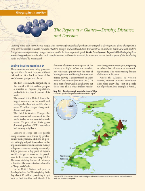
Source: WDR 2009 team (see chapter 3 for details). Note: The width of borders is proportional to a summary measure of each country’s restrictions to the flow of goods, capital, people, and ideas with all other countries.
Cities, migration, and trade have been the main catalysts of progress in the developed world over the past two centuries. These stories are now being repeated in the developing world’s most dynamic economies.
Seeing development in 3-D
These transformations bring prosperity, but they do not happen without risk and sacrifice. Look at three of the world’s most prosperous places:
• The second is the United States, the largest economy in the world and perhaps also the most mobile, where about 35 million people change residences each year.
人文地理学必读书目-0

人文地理学必读书目一、地理书目(一)综合类[1](德)阿尔夫雷德﹒赫特纳著,王兰生译.地理学的历史性质和方法. 北京:商务印书馆,1983年.[2](英) 哈·麦金德著,林尔蔚,陈江译. 历史的地理枢纽. 商务印书馆,1985年。
[3]杨吾扬.地理学思想简史.北京:高等教育出版社,1988年.[4]普雷斯顿.詹姆斯,杰弗雷.马丁著.李旭旦译.地理学思想史.北京:商务印书馆,1989年.(未购买)[5]陆大道. 21区位论和区域研究方法. 北京:科学出版社,1991年.[6]牛文元编著.理论地理学.商务印书馆,1992年。
[7]国家自然科学基金委员会. 地理科学. 科学出版社,1995年。
[8]陆大道.区域发展及其空间结构.科学出版社,1995年.[9]大卫.哈维著. 地理学中的解释. 商务印书馆, 1996年.[10]哈特向著.黎樵译.地理学性质的透视.北京:商务印书馆,1997年.[11]俞孔坚著.景观:文化、生态与感知.科学出版社,1998年。
[12]R.J约翰斯顿. 地理学与地理学家. 商务印书馆,2000年。
[13]刘盛佳.地理学论丛.武汉出版社,2002年。
[14]爱德华·W·苏贾(Edward W Soja)著,周宪,许钧,王文斌译. 后现代地理学:重申批判社会理论中的空间. 商务印书馆,2004年。
[15]大卫·哈维著. 希望的空间. 南京大学出版社,2006年。
[16](美)皮特,周尚意译. 现代地理学思想. 商务印书馆, 2007。
[17](法)保罗·克瓦尔(Claval, P.)著; 郑胜华,刘德美,刘清华等译. 地理学思想史(第3版). 北京大学出版社,2007。
[18]杰弗里·马丁(Martin.G.J.) 著, 成一农, 王雪梅译. 所有可能的世界:地理学思想史(第4版). 上海人民出版社,2008年。
[19](美)苏珊·汉森编,肖平,王方雄,李平译.改变世界的十大地理思想.商务印书馆,2009年。
第四届地理奥赛(武外杯)

地理奥赛动态 第八届国际奥赛 2010·台北
户外测试(占总分的40%)
考察主题:官渡自然保护区的土地利用变化 绘图1 官渡练习中景观特点的变化(时间表) 绘图2 结合实地信息和遥感图片绘制剖面图 问题1 鸟类栖息地的保护与实践 问题2 官渡内的红树林保护问题(红树林是否 要改为鸟类栖息地) 得分分析:绘图总分40,最高26.8,最低7.6。 问题回答满分40,最高34,最低13。
Байду номын сангаас
地理奥赛动态 第八届国际奥赛 2010·台北
户内测试 景观题分析
• 这三幅照片之间有联系, 他们都反映出 • A 滥砍森林和土壤侵蚀 • B 地震 • C 永久冻土层融化 • D 降水和滑坡
地理奥赛动态 第八届国际奥赛 2010·台北
户内测试 综合题分析 千年发展目标
地理奥赛动态 第八届国际奥赛 2010·台北
户内测试 综合题分析 地形
地理奥赛动态 第八届国际奥赛 2010·台北
户外测试(占总分的40%)
野外考察测验包括两个部分 户外绘图练习(mapping excerise)学生有一 上午(4个小时)的时间进行野外考察。组队 方式将打乱国籍,6人一组,由组委会安排组 长全程跟随,掌控时间和路线,保障学生安全。 学生可以用各种设备来观察、记录信息。 室内的地理问题分析。学生得到试卷和额外资 料,有2.5个小时的时间(英语母语国家用时2 小时)完成相关题目。
景观题分析(20%)包括40个问题,每一个问题都
有4个选项,其中只有1个是正确答案。用时1小时。
综合题分析(40%) 试题由6部分组成,用时3小时,
英语母语国家用时2.5小时。
I II III IV V VI 千年发展目标 12分 洪水 人口地理学 地形 农业和环境 自然灾害 13分 14分 13分 13分 15分
自然地理学专业英语重点词汇

01地理学总论地理学geography统一地理学unifiedgeography普通地理学generalgeography系统地理学systematicgeography区域地理学regionalgeography理论地理学theoreticalgeography应用地理学appliedgeography元地理学metageography地文学physiography地质学chorography古地理学paleogeogpraphy地理学体系geographicalsystem地理环境geographicalenvironment地理因子geographicalfactors地理过程geographicalprocess地理分布geographicaldistribution 地理界线geographicalboundary地理综合geographicalsynthesis地理考察geographicalsurvey综合考察integratedsurvey区域分析regionalanalysis区域分异regionaldifferentiation生存空间livingspace生存承载能力life-carryingcapacity 环境决定论environmentaldeterminism 灾变论catastrophetheory地球earth地球表面earthsurface地球表层epigeosphere地理系统geosystem地理圈geographicalsphere景观圈landscapesphere岩石圈lithosphere水圈hydrosphere大气圈atmosphere土壤圈pedosphere生物圈biosphere地圈geosphere智能圈noonsphere技术圈technosphere北半球northernhemisphere南半球southernhemisphere地球体geoid地理纬度latitude地理经度longitude北极NorthPole南极SouthPole极圈ArcticCircle北回归线TropicofCancer南回归线TropicofCapricorn赤道equator时区timezone日界线dateline极昼polarday极夜polarnight洲continent大陆ocean洋sea内陆inland地理单元geographicalunit区划regionalization带belt地带zone区域region 地区area小区district02自然地理学自然地理学physicalgeography综合自然地理学integratedphysicalgeography普通自然地理学generalphysicalgeography自然综合体naturalcomplex地域自然综合体territorialnaturalcomplex自然地理过程physicalgeographicprocess自然生产潜力naturalpotentialproductivity进展因素progressivefactor残留因素relicfactor三维地带性threedimensionzonality水平地带horizontalzone垂直地带verticalzone地带性zonality非地带性azonality水平地带性horizontalzonality垂直地带性verticalzonality地方性locality坡向exposure阳坡adret,sunnyslope阴坡ubac,shadyslope山体效应Massenerhebungseffekt(德),综合自然区划integratedphysicogeographicalregionalization 雪带nivalbelt亚雪带subnivalbelt高山alpine亚高山subalpine山地mountains荒漠化desertification沙漠sandydesert岩漠rockydesert砾漠graveldesert泥漠argillaceousdesert盐漠saltdesert戈壁gobi绿洲oasis景观学landscapescience景观landscape相facies自然景观naturallandscape土地land土地系统landsystem土地分类landclassification土地类型landtype土地单元landunit土地要素landelement土地刻面landfacet刻面联合体facetcombination土地属性terraincharacteristics生态地理学ecogeography地生态学geoecology景观生态学landscapeecology生态系统ecosystem生态平衡ecologicalbalance生态区域ecoregion生态小区ecodistict生态地段ecosection生态区ecotope生态点ecosite自然资源naturalresources可再生资源renewableresources非可再生资源nonrenewableresources 灾害地理学hazardgeography自然灾害naturalhazard地貌学geomorphology地貌landform地貌年代学geomorphochronology地貌成因geomorphogenesis,landformgenesis 地貌形成作用landformformingprocess气候地貌学climaticgeomorphology动力地貌学dynamicgeomorphology地貌量计学geomorphometry人工地貌anthropogeniclandforms平原plain低地lowland高地highland丘陵hill山mountain山脉mountainrange,mountainchain岭range,ridge峰peak,mount山麓piedmont半岛peninsula岛屿island群岛archipelago海峡strait地峡isthmus海拔(高度)altitude,heightabovesealevel 相对高度relativeheight山嘴mountainspur盆地basin山间盆地intermountainbasin山间盆地intermountainbasin山峰mountainpeak崖cliff,scarp山麓平原piedmontplain高原plateau峡谷gorge,canyon谷valley沟谷ravine冲沟gully山形mountainforms山志orography阶地terrace台地tableland,platform洼地depression坡地slope坡度slope,gradient基岩bedrock地貌过程geomorphologicalprocess侵蚀[作用]erosion雨滴侵蚀raindroperosion剥蚀[作用]denudation刻蚀corrasion溶蚀corrosion冲刷wash,erosion片蚀sheeterosion溯源侵蚀headwarderosion下切侵蚀downcutting,incision,verticalerosion 侧[向侵]lateralerosion掏蚀undercutting侵蚀基[准]面baseleveloferosion总侵蚀基[准]面generalbaselevel 局部侵蚀基[准]面localbaselevel 裂点knickpoint沉积作用sedimentation,deposition堆积作用deposition,accumulation堆积物deposit加积作用aggradation沉积相sedimentaryfacies地貌世代generationoflandforms地貌序列landformsseries地形基面baselevel地貌组合landformassemblage正地貌positivelandform负地貌negativelandform正常地貌normallandform倒置地貌invertedlandform地貌倒置inversionoflandform刻蚀地貌erosionallandform夷平作用planationsurface夷平面peneplain准平面denudationsuface剥蚀面erosionsurface山麓[侵蚀]面pediment山麓侵蚀平面pediplain山顶面summitplane侵蚀循环erosioncycle回春作用rejuvenation相关沉积correlatedsediments地壳均衡isostasy新构造运动neotectonicmovement构造地貌学structuralgeomorphology,tectonicgeomorphology丹霞地貌“Danxia”landform构造高原structuralplateau构造阶地structuralterrace单面山cuesta(西)方山mesa猪背脊hogbackridge线形现象lineament断层崖faultscarp断层线崖fault-linescarp断层三角面triangularfacet断层谷triangularfacet断块山faultvalley火山blockmountain火山作用volcano风化[作用]weathering物理风化[作用]physicalweathering化学风化[作用]chemicalweathering生物风化[作用]biologicalweathering机械风化[作用]mechanicalweathering 差异风化[作用]differentialweathering 风化层regolith残积土residualsoil残积物eluvium残积层eluvium风化壳weatheredcrust8正残积风化壳orthoeluvialweatheredcrust碎屑型风化壳clasticweatheredcrust硅铝粘土型风化壳siallite-clayweatheredcrust硅铝碳酸盐型风化壳siallite-carbonateweatheredcrust硅铝-氧化物-硫酸盐风化壳siallite-chloride-sulphatewea-theredcrust 硅铝-铁质和富铝型风化壳siallite-ferriteandallitewea-theredcrustexfoliation,desquamation剥落exfoliation页状剥落crumbling块状崩落incrustation结壳作用crumbling块状崩落incrustation结壳作用talus盐屑堆taluscone盐屑锥山麓堆积talus坡积物slopedeposit坡水堆积物deluvium土体蠕动soilcreep滑塌collapse滑坡landslide,landslip泥石流debrisflow泥流mudflow岩崩rockfall流水地貌学fluvialgeomorphology流水地貌fluviallandform冲积物alluvium,alluvialdeposit冲积层alluvium冲积锥alluvialcone冲积扇alluvialfan洪积物proluvium,proluvialdeposit洪积层proluvium洪积扇proluvialfan河床riverbed河漫滩floodplain汇水区catchmentarea流域drainagearea,basin分水岭waterdivide,divide,watershed 辫状河braidedstream曲流meander天然堤naturallevee滨河床沙坝channelbar,sandbar凸岸坝pointbar牛轭湖ox-bowlake离堆山meandercore,meanderspur河流阶地riverterrace河流袭夺rivercapture河流错位riveroffset河流偏移riverdeflection风口windgap纵谷longitudinalvalley横谷transversevalley风蚀winderosion吹蚀deflation沙丘sanddune新月形沙丘crescentdune流动沙丘mobiledune,wanderingdune固定沙丘fixeddune半固定沙丘semifixieddune纵向沙丘longitudinaldune横向沙丘transversedune抛物线沙丘parabolicdune蜂窝状沙丘honeycombdunes沙垅sandridge风棱石wind-facetedstones,ventifact风蚀脊yardang沙暴sandstorm风蚀坑blowoutpit风蚀洼地deflationhollow干盐湖playa基岩扇rockfan岛山inselberg漠漆desertvarnish岩漆rockvarnish漠盖层desertpavement黄土loess黄土地貌loesslandform黄土塬“yuan,”loesstableland黄土梁“liang,”loessridge黄土峁“mao,”loesshill 劣地badland咯斯特karst咯斯特地貌学karstgeomorphology咯斯特地貌karstlandform咯斯特化karstification溶斗doline溶蚀谷polje溶蚀盆uvala落水洞sinkhole溶沟karren干谷dryvalley竖井shaft潜蚀作用undergrounderosion洞穴堆积cavedeposit咯斯特平原karstplain峰林peakforest石林stonepinacles洞穴学speleology假咯斯特pseudokarst类咯斯特parakarst泉华沉积sinterdeposition石灰华tufa海岸seacoast滨shore海岸地貌学coastalgeomorphology海蚀作用marineerosion海蚀龛wave-cutnotch海蚀洞seacave海蚀台abrasionplatform海蚀崖seacliff海蚀柱seastack岬角cape岩滩bench潮滩tidalflat潮汐通道tidalchannel,tidalinlet潮沟tidalcreek舄湖lagoon 三角洲delta河口湾estuary海滩coastalbeach滩脊beachridge滩脊[型]潮滩chenier滩脊[型]潮滩平原chenierplain 沙嘴sandspit障壁坝barrier滨外坝off-shorebar尖[形]滩cuspateforeland尖[形]坝tuspatebar 连岛坝tombolo陆连岛tomboloisland沿滨泥沙流longshoredrift海岸阶地coastalterrace,marineterrace全球性海面升降eustaticmovement珊瑚礁coralreef岸礁fringingreef堡礁barrierreef环礁atoll大陆架continentalshelf大陆坡continentalslope洋盆oceanicbasin海隆rise海岭oceanicridge平顶海山guyot海沟trench海渊abyssaldeep04气候学气候学climatology气候climate气候资源climateresources太阳辐射solarradiation反照射albedo积温accumulatedtemperature无霜期frost-freeperiod降水precipitation蒸发evaporation干燥度aridity热水平衡heat-waterbalance风向winddirection风速windspeed气候灾害climatedamage,climatichazard旱灾droughtdamage水灾flooddamage风灾winddamage雹灾haildamage湿害wetdamage热害heatdamage冻害freezingdamage冷害colddamage气候分类climaticclassification气候区划climaticregionalization气候带climaticzone气候区climaticregion气候型climatictype赤道带equatorialzone热带tropicalzone亚热带subtropicalzone温带temperatezone寒带coldzone湿润气候humidclimate干燥气候aridclimate热带雨林气候tropicalrainforestclimate 萨瓦纳气候savannaclimate森林气候forestclimate草原气候steppeclimate荒漠气候desertclimate苔原气候tundraclimate极地气候polarclimate高原气候plateauclimate山地气候mountainclimate大陆度continentality大陆性气候continentalclimate海洋性气候maritimeclimate地中海气候Mediterraneanclimate地形气候学topoclimatology区域气候regionalclimate地方气候localclimate小气候microclimate气候系统climaticsystem行星风系planetarywindsystem信风tradewind,trades季风monsoon梅雨Meiyu,,plumrain台风typhoon寒潮coldwave海陆风sea-landbreeze山谷风mountain-valleybreeze 干热风dry-hotwind焚风foehn雨影rainshadow气候变迁climaticchange古气候palaeoclimate历史气候historicalclimate 年轮气候学dendroclimatology 物候学phenology自然历naturalcalendar城市气候urbanclimate城市热岛urbanheatisland气候志climatography05水文地理学水文地理学hydrogeography水文学hydrology水体waterbody水团watermass河流学potamology水利学hydraulics水利经济学hydroeconomics水化学hydrochemistry森林水文学foresthydrology都市水文学urbanhydrology水文物理学hydrophysics古水文学palaeohydrology土壤水文学pedohydrology水文情势hydrologicalregime水文过程hydrologicalprocess水文测验hydrometry流域形态watershedmorphology流域分水线basindivide河道坡降channelgradient河道等级channelorder闭合盆地closedbasin 河网密度drainagedensity总蒸发evapotranspiration水平衡waterbudget,waterbalance陆面蒸发landevaporation水面蒸发watersurfaceevaporation分岔系数forkfactor河源headwaters水道网hydrographicnet支流tributary过程线hydrograph流量过程线分割separationofhydrograph瀑布waterfall水平降水horizontalprecipitation水循环watercycle水量交换waterexchange径流runoff径流系数runoffcoefficient年正常径流量annualnormalrunoff基流baseflow河床变形riverbeddeformation河流补给riverfeeding暴发洪水flashflood洪水flood流水过程fluvialprocesses层间流interaquiferflow壤中流interflow河流数目定律lawofstreamnumbers叠加定律lawofsuperposition流量discharge坡面流overlandflow洪峰流量peakdischarge产流runoffgeneration汇流flowconcentration产沙率rateofsedimentproduction 退水曲线recessioncurve径流模数runoffmodulus产水量wateryield悬移质suspendedload泥沙运动sedimentmovement产沙量sedimentyield水位waterstage洪水位floodlevel警戒水位warningstage水土流失waterandsoilloss水土保持waterandsoilconservation涝waterlogging暴雨径流stormflow输沙能力transportabilityofsediments 径流变率variabilityofrunoff地下水文学groundwaterhydrology承压地下水confinedgroundwater水力传导度hydraulicconductivity入渗infiltration土壤水soilwater含水层aquifer自流水盆地artesianbasin深层地下水deepphreaticwater裂隙水fissuredwater地下水位watertable矿泉mineralspring地下河undergroundriver饱和带saturationzone湖沼学limnology湖泊水文学lakehydrology湖流lakecurrent水质waterquality湖泊富营养化lakeeutrophication人工湖man-madelake盐湖saltlake咸水湖salt-waterlake淡水湖freshwaterlake构造湖tectoniclake,structurallake层结湖stratifiedlake季节性湖泊seasonallake火山湖volcaniclake高山湖alpinelake游移湖wanderinglake热湖warmlake微咸湖brackish-waterlake干涸湖extinctlake完全混和湖holomixedlake湖盆lakecirculation湖水环流lakecirculation湖泊蓄水量lakestorage冰川补给alimentationofglacier积雪水文学alimentationofglacier融雪水文学snowhydrology融雪径流snowrunoff有潮河口tidalestuary无潮海tidelesssea波浪侵蚀waveerosion地下水库groundwaterreservoir水资源waterresources供水Watersupply 水能hydropower06生物地理学生物地理学biogeography生物分布学chorology生物分布biochores分布区areal分布区中心areakcenter分布区间断arealdisjunction 分布区型arealtype扩散中心dispersalcenter残遗种区refugium种群population生物群biota生物地理群落biogeocoenosis 生境habitat小生境niche,microhabitat 群落生境biotope植物地理学phytogeography 植物区系flora生活型lifeform生活型谱lifeformspectrum 水生植物hydrophyte湿生植物hygrophyte中生植物mesophyte旱生植物xerophyte指示植物indicatorplant指示群落indicatorcommunity 植被vegetation植物群落plantcommunity群丛association群系formation植被型vegetationtype顶级群落climax演替succession针叶林coniferousforest泰加林taiga落叶林deciduousforest常绿阔叶林evergreenbroad-leavedforest硬叶林sclerophyllousforest照叶林laurelforest季[风]雨林monsoonforest 雨林rainforest红树林mangrove苔原tundra森林草原foreststeppe草原steppe高草草原prairie萨瓦纳savanna普那高原puna草甸meadow高山矮曲林alpinekrummholz森林上限upperforestlimit树线timberline动物地理学zoogeography动物区系fauna地理阻障geographicalbarriers动物传布synzoochory 华莱士线wallace’sline动物群落animalcommunity泛北极Holarctic古北界Palaearctic新北界Neoarctic旧热带界Palaeotropic新热带界Neotropic东洋界Oriental澳洲界Australasian土壤地理学pedogeography 土被soilmantle土链soilcatena土壤组合soilassociation 土壤复区soilcomplex土壤气候soilclimate土壤资源soilresources土壤退化soildegradation 土壤侵蚀soilerosion古土壤paleosoil森林土壤forestsoil草原土壤desertsoil荒漠土壤desertsoil高山土壤highmountainsoil 幼年土壤youngsoil成熟土壤maturesoil顶级土壤climaxsoil灰化土podzolicsoil棕壤brownearth褐土cinnamonsoil黄壤yellowearth红壤redearth砖红壤laterite黑钙土chernozem栗钙土chestnutsoil棕钙土brownsoil灰漠土graydesertsoil棕漠土browndesertsoil盐土solonchak碱土solonertz化学地理学chemicalgeography景观地球化学landscapegeochemistry地球化学景观geochemicallandscape自成景观autonomiclandscape从属景观auxiliarylandscape残积景观eluviallandscape水上景观superaquallandscape水下景观subaquallandscape水成景观aqueouslandscape,aquallandscapeelementarylandscape 单元景观biogeniclandscape生源景观abiogeniclandscape非生源景观aerialmigration大气迁移aqueousmigration水迁移biologicalmigration生物迁移mechanicalmigration机械迁移chemicalmigration,physico-chemical化学迁移migrationtypomorphicelement 标型元素typomorphiccompound标型化合物typomorphicion标型离子chemicaldenudation化学剥蚀环境地理学environmentalgeography环境地球化学environmentalgeochemistry 自然环境naturalenvironment社会环境socialenvironment区域环境regionalenvironment海洋环境marineenvironment环境系统environmentalsystem环境结构environmentalstructure环境要素environmentalelement环境演化environmentalevolution环境背景值environmentalbackgroundvalue 环境异常environmentalabnormality环境自净environmentalself-purification环境容量environmentalcapacity景观损害landscapedamage环境退化environmentaldegradation环境效应environmentaleffect环境污染environmentalpollution大气污染atmosphericpollution水污染waterpollution土壤污染soilpollution海洋污染marinepollution环境经济environmentaleconomy环境管理environmentalmanagement环境标准environmentalstandard环境质量environmentalquality环境质量参数environmentalqualityparameter环境质量指数environmentalqualityindex环境质量评价environmentalqualityevaluation环境影响评价environmentalimpactassessment环境质量综合评价environmentalqualitycomprehensiveevaluation 环境保护environmentalprotection环境规划environmentalplanning环境区划environmentalregionalization环境设计environmentaldesign自然保护conservationofnature自然保护区naturereserve自然资源保护conservationofnaturalresources生物资源保护livingresourcesconservation水资源保护protectionofwaterresources国家公园nationalpark地面沉降landsubsidence公害publicnuisance公害病publicnuisancedisease水悮病minamatadisease痛痛病itai-itaidisease11冰川学冰川学glaciology积雪snowcover粒雪firn粒雪化作用firnification粒雪盆firnbasin雪线snowline吹雪snowdrift雪崩avalanche雪蚀nivation陆冰landice冰山iceberg冰川glacier冰盖icesheet冰原icefield冰川化glacierization冰川作用glaciation冰川物质平衡glaciermass-balance 消融区ablationarea积累区accumulationarea冰川隙crevasse冰川地质学glacialgeology角峰horn冰斗cirqueU形谷U-shapevalley鼓丘drumlin羊背石rochemoutonnee冰擦痕glacialstria冰川河流glacialstream冰下河道subglacialchannel漂砾boulder纹泥varve海洋性冰川maritimeglacier大陆性冰川continentalglacier 极地冰川polarglacier山岳冰川mountainglacier冰斗冰川cirqueglacier悬冰川hangingglacier冰川变化glacialfluctuation 冰川退缩deglaciation冰期iceage小冰期littleiceage新冰期neoglaciation冰期后post-glacial间冰期interglacialperiod冷圈cryosphere冷圈学cryology12冻土学冻土学geocryology,cryopedology冻土frozenground融土meltedsoil季节冻土seasonalfrozenground多年冻土permafrost高山冻土alpinepermafrost冻土动力学permafrostdynamics冻土退化permafrostdegradation冻土进化permafrostaggradation富冰冻土icepermafrost冻结层中水interpermafrostwater冻土相分析permafrostphase-analyses冻融循环freeze-thawcycles冻结指数freezingindex融化指数thawingindex零点幕zerocurtain成冰作用iceformation冰胶结cementice冰分凝segregatedice地下水groundice冰透镜体icelens冰含量icecontent冻胀frostheaving冻胀力frostheavingforce冰缘periglacial寒冻风化cryogenicweathering,frostweathering 热喀斯特thermokarst热喀斯特湖thermokarstlake冰锲icewedge翻浆frostboilWORD格式13沼泽学沼泽学mirescience沼泽mire,swamp盐沼saltmarsh草甸沼泽meadowmarsh苔藓沼泽sedgemarsh,芦苇沼泽reedmarsh,phragmitesmarsh藓类沼泽massbog颤沼quakingmire,floatingmire林地沼泽forestmarsh红树林沼泽mangroveswamp海滨沼泽coastalmarsh滩地沼泽fluvialmarsh阶地沼泽terracemarsh平原沼泽plainmarsh高山沼泽plateaumarsh山地沼泽mountainmire,uplandmire沼泽形成过程mireformationprocess沼泽水文mirehydrology,peatlandhydrology沼泽植物mireplant低位沼泽fen中位沼泽transitionalmire高位沼泽raisedbog富营养沼泽eutrophicmire中营养化沼泽mesotrophicmire贫营养化沼泽oligotrophicbog沼泽化paludification沼泽生态系统mireecosystem沼泽率mirearea泥炭peat湿地wetland30专业资料整理。
地理学科 英文

地理学科英文Geography as a Discipline: Exploring Its Depth and BreadthGeography, as a field of study, holds immense value in understanding the complexities of our planet and its inhabitants. It is an interdisciplinary science that integrates physical, cultural, environmental, social, and political aspects of the Earth's surface, making it a unique and diverse discipline. In this article, we will delve deeper into the intricacies of geography, discussing its various subfields, methodologies, and the significance of geography in today's world.Geography can be broadly classified into two main branches: physical geography and human geography. Physical geography focuses on the natural features and processes of the Earth's surface, including landforms, climate, hydrology, soils, and vegetation. It employs scientific methods to study the Earth's physical environment and how it interacts with the atmosphere, oceans, and biosphere. On the other hand, human geography examines the spatial patterns and relationships between people and theirenvironments, covering topics such as population distribution, urbanization, cultural landscapes, and political geography.Within these broad categories, geography encompasses numerous subfields that allow for more specialized and focused research. For instance, environmental geography studies the interactions between human activities and the natural environment, addressing issues such as pollution, climate change, and sustainable development. Economic geography analyzes the spatial distribution of economic activities, including trade, production, and consumption, while political geography explores the geographical dimensions of political power and conflict.The methodologies employed in geography are diverse and vary depending on the specific subfield and research question. Geographers often use a combination of quantitative and qualitative methods, including fieldwork, remote sensing, GIS (Geographic Information Systems), and statistical analysis. Fieldwork allows geographers to collect primary data through observations and measurements, while remote sensing techniques, such as satellite imagery,provide valuable data on the Earth's surface from afar. GIS, on the other hand, enables geographers to process, analyze, and visualize spatial data, enhancing their understandingof geographical patterns and relationships.The significance of geography in today's world cannotbe overstated. It plays a crucial role in understanding and addressing global challenges such as climate change, environmental degradation, urbanization, and globalization. Geographers provide insights into the spatial dimensions of these issues, highlighting the interconnectedness ofnatural and human systems and the need for sustainable development. In addition, geography contributes to our understanding of cultural and social diversity, fostering a more inclusive and tolerant society.Moreover, geography is also relevant in fields such as education, planning, and policy-making. Educators often utilize geographical concepts and methods to enhance students' understanding of the world and their place within it. Planners rely on geographical knowledge to create sustainable and livable cities and communities, while policymakers use geographical information to formulateeffective policies that address regional and global challenges.In conclusion, geography is a multifaceted and diverse discipline that offers insights into the complexities of our planet and its inhabitants. By studying theinteractions between physical and human systems, geographers contribute to our understanding of the world and help us navigate the challenges of the 21st century. As we continue to face global issues that require transdisciplinary approaches, the role of geography in informing and guiding our actions becomes increasingly important.。
World Regional Geography 4-2009
PACIFIC ASIA Tropical rainforests
Destruction of tropical rainforests:
Rainforests used to cover 14% of the earth surface, but now this is only 6%. The remaining rainforests could disappear within 40 years at the present rate of logging.
PACIFIC ASIA Development
Theories to explain underdevelopment
Geodeterministic theories: Climate, surface, location, lack of resources as reasons Dependency theories: Colonialism and exploitation as reasons Modernisation theories: Lack of innovation and modernisation as reasons
South East Asia had the oldest and richest rainforests, but they are being destroyed faster than those in Africa and Brazil. Mostly by timber logging companies for export to Japan and other developed countries, or cleared for domestic farming, industrial or urban use.
人文地理学必读书目-0

人文地理学必读书目一、地理书目(一)综合类[1](德)阿尔夫雷德﹒赫特纳著,王兰生译.地理学的历史性质和方法. 北京:商务印书馆,1983年.[2](英) 哈·麦金德著,林尔蔚,陈江译. 历史的地理枢纽. 商务印书馆,1985年。
[3]杨吾扬.地理学思想简史.北京:高等教育出版社,1988年.[4]普雷斯顿.詹姆斯,杰弗雷.马丁著.李旭旦译.地理学思想史.北京:商务印书馆,1989年.(未购买)[5]陆大道. 21区位论和区域研究方法. 北京:科学出版社,1991年.[6]牛文元编著.理论地理学.商务印书馆,1992年。
[7]国家自然科学基金委员会. 地理科学. 科学出版社,1995年。
[8]陆大道.区域发展及其空间结构.科学出版社,1995年.[9]大卫.哈维著. 地理学中的解释. 商务印书馆, 1996年.[10]哈特向著.黎樵译.地理学性质的透视.北京:商务印书馆,1997年.[11]俞孔坚著.景观:文化、生态与感知.科学出版社,1998年。
[12]R.J约翰斯顿. 地理学与地理学家. 商务印书馆,2000年。
[13]刘盛佳.地理学论丛.武汉出版社,2002年。
[14]爱德华·W·苏贾(Edward W Soja)著,周宪,许钧,王文斌译. 后现代地理学:重申批判社会理论中的空间. 商务印书馆,2004年。
[15]大卫·哈维著. 希望的空间. 南京大学出版社,2006年。
[16](美)皮特,周尚意译. 现代地理学思想. 商务印书馆, 2007。
[17](法)保罗·克瓦尔(Claval, P.)著; 郑胜华,刘德美,刘清华等译. 地理学思想史(第3版). 北京大学出版社,2007。
[18]杰弗里·马丁(Martin.G.J.) 著, 成一农, 王雪梅译. 所有可能的世界:地理学思想史(第4版). 上海人民出版社,2008年。
[19](美)苏珊·汉森编,肖平,王方雄,李平译.改变世界的十大地理思想.商务印书馆,2009年。
区域地理学的名词解释
区域地理学的名词解释区域地理学是地理学的一个重要分支,在研究地球表面区域差异和空间分布规律方面发挥着重要的作用。
本文将对区域地理学相关的名词进行解释,帮助读者更好地理解这个学科领域。
1. 区域地理学(Regional Geography)区域地理学可以定义为对地球上的特定区域进行系统性研究的学科。
它关注区域之间的差异和相似之处,研究区域内的自然地理、人文地理和环境问题。
区域地理学专注于特定地理区域的形成原因、区域特色、演变过程和区域发展规律。
2. 区域(Region)区域是指在空间上具有一定独特性和边界的地理单元。
区域的划分可以根据自然地理特征、人文特征和经济特征进行分类。
一个区域可以由一个或多个特征相似的地理单元组成,其研究对于理解地理现象的空间分布具有重要意义。
3. 区域分类方法(Regionalization)区域分类方法是将地理区域划分为不同的类别或类型的过程。
这个过程可以根据不同的分类指标和研究目的进行,常用的分类指标包括自然环境因素、人文经济因素以及历史文化因素。
4. 区域类型(Regional Type)区域类型指的是根据一些共同的特征或属性而将地理区域归类到同一类别的过程。
不同的区域类型可以反映不同的地理现象和特征。
例如,农业区、工业区、海洋区等都是根据其特定属性而进行划分的区域类型。
5. 区域一体化(Regional Integration)区域一体化是指在经济、政治和文化等方面,不同国家或地区通过共同协议和合作达到相互融合、互利共赢的目标。
区域一体化可以促进地理区域内的经济发展、贸易流通和资源共享。
6. 区域发展(Regional Development)区域发展是指特定区域经济、社会和环境等方面的发展过程和结果。
区域发展研究关注不同地理区域内经济差异的形成原因、区域发展不平衡问题以及如何促进区域发展的策略。
7. 区域规划(Regional Planning)区域规划是指对特定地理区域进行有计划的发展和利用的过程。
用英语介绍世界地理范文

用英语介绍世界地理范文英文回答:Introduction.World geography is the study of the physical and human features of the Earth. It is a branch of social studies that encompasses a wide range of topics, including:Physical geography: The study of the Earth's physical characteristics, such as its landforms, climate, and water resources.Human geography: The study of how humans interact with the environment, including topics such as population, culture, and economics.Regional geography: The study of specific regions of the world, such as North America, Europe, or Asia.Cartography: The study of maps and how they are used to represent the Earth's surface.Importance of World Geography.World geography is important because it helps us to understand the world around us. It can help us to:Understand different cultures: Geography can help us to understand why different cultures have developeddifferently, based on their physical and human environments.Make informed decisions: Geography can help us to make informed decisions about issues such as climate change, resource management, and land use planning.Appreciate the beauty of the Earth: Geography can help us to appreciate the beauty and diversity of the Earth's physical features.Careers in World Geography.There are many different careers that involve world geography, including:Geographers: Geographers study the Earth's physical and human features. They may work for government agencies, universities, or private companies.Cartographers: Cartographers create maps that represent the Earth's surface. They may work for government agencies, publishing companies, or private companies.Urban planners: Urban planners design and plan cities and towns. They may work for government agencies or private companies.Environmental scientists: Environmental scientists study the impact of human activities on the environment. They may work for government agencies, universities, or private companies.Conclusion.World geography is a fascinating and important subject that can help us to understand the world around us. It is a subject that has a wide range of applications, and it can lead to a variety of careers.中文回答:世界地理。
区域地理学原理

区域地理学原理One of the fundamental principles of regional geography is the concept of regionalization, which involves dividing the Earth's surface into distinct regions based on various criteria such as physical features, culture, economic activities, and political boundaries. 区域地理学的一个基本原理是区域化的概念,这涉及根据诸如地理特征、文化、经济活动和政治边界等各种标准将地球表面划分为不同的区域。
Regional geography seeks to understand the unique characteristics of different regions and how they are interconnected with one another. 区域地理学旨在了解不同区域的独特特征以及它们之间的相互关联。
One perspective in regional geography is the study of human-environment interactions, which examines how human activities and the natural environment interact and influence each other. 区域地理学的一个视角是人地关系的研究,该研究探讨了人类活动和自然环境如何相互作用并相互影响。
Another perspective is the regional analysis of economic activities, which involves examining the spatial distribution of economic activities, such as agriculture, industry, and trade, within different regions. 另一个视角是经济活动的区域分析,该分析涉及研究不同区域内农业、工业和贸易等经济活动的空间分布。
重塑世界经济地理(2009年世界发展报告概述)
重塑世界经济地理(2009年世界发展报告概述)The International Bank for Reconstruction and Development/ The World Bank,1818 H Street, NW,Washington,D.G.20433,USA.【期刊名称】《城市与区域规划研究》【年(卷),期】2009()3【摘要】世界银行的年度出版物——《世界发展报告》,自1978年起开始发表,今年是第31期。
《2009年世界发展报告:重塑世界经济地理》由世界银行发展经济局和可持续发展网络共同发起,报告由英德米特·吉尔(Indermit Gill)领导的工作组执笔编写,布鲁斯·罗思-拉森(Bruce Ross-Larson)担任主编。
罗伯特·佐立克(Robert Zoellick)行长为报告作序。
该报告的英文版于2008年11月由世界银行出版,中文版由清华大学出版社于2009年2月正式出版。
本文由清华大学建筑学院毛其智教授摘编自该报告中文文件中"概述"一节。
【总页数】34页(P135-168)【作者】The International Bank for Reconstruction and Development/ The World Bank,1818 H Street, NW,Washington,D.G.20433,USA.【作者单位】国际复兴开发银行;世界银行【正文语种】中文【中图分类】F119.9【相关文献】1.亚欧"世界岛"和重塑国内外经济地理 [J], 安虎森;郑文光2.世界石油石化行业将进入新一轮调整期——《2008年国内外油气行业发展报告》国际部分概述 [J], 《国际石油经济》编辑部3.2009年世界发展报告:重塑世界经济地理 [J], 世界银行驻华代表处4.重塑经济地理:世界经验和四川的选择 [J], 林凌;刘世庆;付实5.一场重塑世界经济地理的革命 [J], ;因版权原因,仅展示原文概要,查看原文内容请购买。
International geography
International geography《国家地理》是美国国家地理学会的官方杂志,美国国家地理杂志创刊于1888年,它由美国的一家非盈利科学教育组织——“国家地理协会”(National Geographic Society)创.在国家地理学会1888年创办的九个月后即开始发行。
现在已经成为世界上最广为人知的一本杂志,其封面上的亮黄色边框以及月桂纹图样已经成为象征,同时这些标识也是国家地理杂志的注册商标。
杂志每年发行12次,但偶尔有特版发布则不在此限。
杂志内容为高质量的关于社会、历史、世界各地的风土人情的文章;其印刷和图片之质量标准也为人们所称道。
这也使得该刊成为来自世界各地的摄影新闻记者们梦想发布自己照片的地方。
早在20世纪初期,国家地理杂志即已经开始使用一些当时罕见的彩色照片文章在过去的几年,杂志的开篇文章总是涉及到环境,森林砍伐,化学污染,全球变暖和濒危物种,一系列的主题远远超过了地理探索的好奇心。
杂志发表的一些文章还重点涉及到历史和新产品,新技术在当今社会中的应用,比如说一种金属,基因技术,食物和农产品或者是新的考古发现。
有时整个一期杂志的焦点集中到一个国家之上(它的过去的文明,自然资源,或其他题目)。
在最近的几十年里美国国家地理学会还发行了其他的,主要关于其他主题的杂志照片这本杂志成为来自世界各地的摄影新闻记者梦想发布自己的照片的地方。
早在20世纪初期,国家地理已经开始使用一些当时很罕见的彩色照片了,尽管这种技术在当时还是很罕见的同其他的杂志不同,国家地理经常被读者经年收藏,从2006年起,国家地理参加了由超过18个国家参与的国际摄影竞赛地图作为对文章的补充,国家地理有时还提供被介绍地区的地图。
国家地理学会的地图曾经为美国联邦政府所采用以弥补军方地图资源的不足。
美国总统富兰克林·罗斯福白宫地图室里地图大部分是国家地理的地图。
国家地理欧洲地图被收藏在伦敦温斯顿·丘吉尔博物馆里,地图上可以看到当时丘吉尔在由盟军和苏联领导人划分战后欧洲参加的雅尔塔会议上的标记。
- 1、下载文档前请自行甄别文档内容的完整性,平台不提供额外的编辑、内容补充、找答案等附加服务。
- 2、"仅部分预览"的文档,不可在线预览部分如存在完整性等问题,可反馈申请退款(可完整预览的文档不适用该条件!)。
- 3、如文档侵犯您的权益,请联系客服反馈,我们会尽快为您处理(人工客服工作时间:9:00-18:30)。
Europe and the European Union
Europe:
Before 1990: 33 independent states Now: 45 independent states
European Unification
1. ECSC European Community for Steel and Coal 2. EEC European Economic Community 3. EC European Community 4. EU European Union
nature
culture
economy
society
What do Geographers do? System of the discipline
What is Geography?
Two main characteristics What do Geographers do?
Describe Find patterns models Explain theories Develop strategies (Applied Geography)
The World
How can we divide the world into regions?
Dividing the world into Regions
Criterion - Aspect by which to make a decision Possible criteria for dividing the world into major regions (realms):
European diversity
Physical diversity
Many islands and peninsulas Dividing mountain ranges Multitude of landscapes
Cultural diversity
Physical diversity creates cultural diversity Many languages and dialects Different local customs and food
Summer season
Demand declining, but still higher (e.g. from Eastern Europe) Suffers from higher costs and environmental degradation Desirable because better distribution of revenue -> Innovative concepts activity tourism eco-tourism
Political diversity
Cultural diversity leads to political diversity Many independent states in a small region
European Nations and States
Europe is divided in many nations and states
Differentiate: Region vs. Area Region vs. Place Region vs. Country
The world can be viewed as divided into approximately 8-10 very big regions, which are sometimes called realms.
What is Geography?
Two main characteristics Spatial - about places, regions, space Integrative - linking different perspectives
Spatial system
Interdependence
System of the discipline
What is Geography?
Two main characteristics What do Geographers do? System of the discipline
1. Regional vs. systematic geography 2. Physical vs. human geography
What is Europe?
What is Europe?
Cultural criteria
Social order, values, religion, languages, arts, architecture,… Important: Christianity, Indo-European languages
Alpine region
Alpine tourism
Tourism has replaced agriculture as the main economic activity Problem: High dependence on tourism
Growing: - short-term tourism - Long-distance tourism - expensive types of accommodation - winter season Declining: - long family holidays - short-distance tourism - private family accommodation (Austria) - summer season
How can we divide Europe into sub regions?
Climatically 4 climate zones Culturally 9 language groups Politically about 45 states groups of states Physically landscape types …
Different political tradition Different interests Historically many conflicts
But recently they give away power to the European Union. What are the advantages?
THE
MEDITERRANEAN REGION
THE
MEDITERRANEAN REGION
Main points attracting tourists: Old culture (ancient relics, museums, religious tourism) Climate (dry, warm summer) Sea, beaches Local cuisines and popular culture entertainment
• • • • • Physical continents Climate zones Groups of states Cultural realms Cores and peripheries
The world divided into regions Find the major differences
Europe Russia and Central Asia North America Asia-Pacific South Asia (and the Middle East)
What is Geography?
Two main characteristics What do Geographers do? System of the discipline
WORLD REGIONAL GEOGRAPHY
Dr. Werner Breitung
breitung@
2009
World Regional Geography
What is geography? Realms and regions Some world regions
o o o o o
Number of member states
1957:
6 1973:9 1986:12 1995:15 2004:25
2007:
27
பைடு நூலகம்
Enlargement of the European Union
6 1973 9 1986 12 1995 15 2007 27
1957
EUROPE: TOURISM GEOGRAPHY
Physical criteria
Climate, drainage, mountain ranges Commonly accepted boundaries: Ural mountains, Ural river, Caucasus
Political criteria
European Union ≠ Europe Europe as a culture area
The System of Geography
What is a Region?
Region: Part of the earth surface, which appears as a distinct unit because it shares certain characteristics and differs from the surrounding areas.
Peace and understanding among the European nations Bigger market and more efficiency with open borders More political power internationally Balanced development of different European regions Better efficiency of policies through co-operation Research, environment, transport, aid to other countries,…
