ArcGIS 中文件扩展名的含义
ArcGIS的数据结构
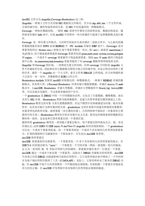
ArcGIS文件分为shapefile,Coverage,Geodatabase这三种。
Shapefile:一种基于文件方式存储GIS数据的文件格式。
至少由.shp,.dbf,.shx三个文件作成,分别存储空间,属性和前两者的关系。
是GIS中比较通用的一种数据格式。
Coverage:一种拓扑数据结构,一般的GIS原理书中都有它的原理论述。
数据结构复杂,属性缺省存储在Info表中。
目前ArcGIS中仍然有一些分析操作只能基于这种数据格式进行操作。
Coverage是一种矢量文件格式,几何和空间拓扑关系存储在二进制文件中,与之相关的属性数据则被存放在INFO表或RDBMS中(PC ArcInfo存储在DBF表中)。
Coverages是对要素类组织后(feature class)的集合,每个要素类都是一些点,线(arcs),面或者annotation(文本)的集合,用于描述地理要素的Coverage要素类包括point,node,route system,section,polygon 和region。
一个或多个coverage要素被用于构造地理要素,例如arcs和node被用于构造街道中心线,tic,annotation,link,boundary要素类提供了对coverage数据管理和浏览的支持。
Shapefile和Coverage的区别:二者都是矢量文件结构,但和coverage不同的是shapefile文件不存储拓扑信息,因此相对其它数据格式要较少地占用存储空间,在显示和访问效率上要快许多。
通常一个shapefile由一个主文件,索引文件和DBASE文件组成,在几何和属性基于记录号一对一对应,其数据格式ESRI已经公开。
Geodatabase:ArcInfo发展到ArcGIS时候推出的一种数据格式,一种基于RDBMS存储的数据格式,其有两大类:1.Personal Geodatabse 用来存储小数据量数据,存储在Access的mdb 格式中。
ArcGIS的一些名词解释 (2)

【ESRI】ArcGIS的一些名词解释AML宏语言AML是在ARC环境中用于编程和创建应用的语言。
AML提供完整的编程能力和一套工具来创建应用的用户界面。
叠置分析是把两层和多层地图要素叠加产生一个新图层的操作。
叠置分析可以应用于矢量图层的叠置、栅格GRID的叠加以及地理事件的叠加等。
区域查询是从多个图层中查询满足一定条件的特征,从而创建一个新的图层的空间分析操作。
该工具也可以创建满足条件的区域子类。
ArcGIS Desktop是一个集成了众多高级GIS应用的软件套件,它包含了一套带有用户界面组件的Windows桌面应用(例如,ArcMap,ArcCatalog,ArcToobox)。
ArcSDE是在各种关系型数据库管理系统中管理地理信息的高级空间数据服务器。
ArcIMS是通过开放的Internet协议发布地图、数据和元数据的可伸缩的网络地图服务器。
ArcMap 是一个用于编辑、显示、查询和分析地图数据的以地图为核心的模块,ArcMap包含一个复杂的专业制图和编辑系统,既是一个面向对象的编辑器,又是一个完整的数据表生成器。
ArcCatalog 是以数据为核心,用于定位、浏览和管理空间数据的模块,是用户规划数据表,用于制定和利用元数据的环境,应用模块帮助你组织和管理你所有的GIS 信息,比如地图,数据集,模型,元数据,服务等。
ARCTOOLBOX是用于完成ARCGIS所提供的数据转换、叠加处理、缓冲区生成和投影变换等空间数据分析的处理环境。
MapObjects是一组供应用开发人员使用的制图与GIS功能组件。
它由一个OLE控件和一系列可编程OLE对象组成。
利用MapObjects,开发人员可以在应用程序中添加制图和GIS功能。
ArcGIS Engine是一个完整的嵌入式GIS组件库和工具包,开发者能用它创建一个新的、或扩展原有的可定制的桌面应用程序。
ArcGIS Server是一个中心应用服务器,它包含一个可共享的GIS软件对象库,能在企业和Web计算框架中建立服务器端的GIS应用。
ArcGIS三大文件格式解析
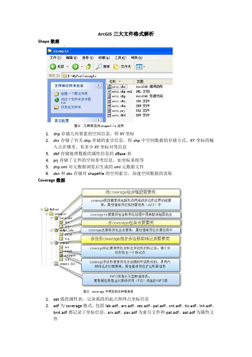
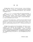
ArcGIS三大文件格式解析Shape数据1. shp存储几何要素的空间信息,即XY坐标2.shx存储了有关.shp存储的索引信息,即shp中空间数据的存储方式,XY坐标的输入点在哪里,有多少XY坐标对等信息3.dbf存储地理数据的属性信息的dBase表4.prj存储了文件的空间参考信息,如坐标系统等5.shp.xml对元数据浏览后生成的xml元数据文件6.sbn和sbx存储对shapefile的空间索引,加速空间数据的读取Coverage数据1.aat弧段属性表,记录弧段的起点和终点坐标信息2.adf为coverage格式,包括lab.adf、arc.adf、sec.adf、pal.adf、cnt.adf、tic.adf、lnk.adf、bnd.adf都记录了坐标信息,arx.adf、pax.adf为索引文件和pat.adf、aat.adf为属性文件3.pat点属性表,记录lable点的坐标信息4.tic控制点,用于配准地图的点5.aux保存栅格文件自身不能保存的辅助信息,包括彩色地图信息,直方图或表格,坐标系统,变换信息,投影信息6.rrd保存影像金字塔信息索引,加速显示和漫游7.dat属性信息8.nit属性表定义文件9.dir属性表路径管理文件,用于关联dat和nitGeodatabase数据∙adf - ARC/INFO coverage data file∙agf - Atlas GIS native binary geodataset file∙ain - attribute index file∙aih - attribute index file∙alg - ER Mapper algorithm∙apr - ArcView Project File (ODB format)∙avl - legend template file (ODB format)∙avp - palette file (ODB format)∙ave - Avenue script∙avx - ArcView extension file (ODB format)∙ai - Adobe Illlustrator picture file∙bat - DOS batch file∙bil - image file (band interleaved by line)∙bip - image file (band interleaved by pixel)∙blw - world file for bil image∙bmp - Windows bitmap image file∙bpw - world file for bip or bmp images∙bsq - image file (band sequential)∙bqw - world file for bsq image∙ c - C programming language source code filename∙cat - UNIX hyperhelp supporting file∙cgm - Computer Graphics Metafile∙cls - geocoding classification file∙cnt - help file contents∙dat - generic data file extension dat - INFO attribute file∙db - Object Database File (also ODB)∙dbf - dBASE tabular data file∙dbf - Shapefile attribute table file∙dbg - problem debug log file∙dcp - default codepage file∙dct - geocoding dictionary file∙dec - UNIX hyperhelp supporting file∙def - defaults file (North Arrows, Layout Templates, etc) (ODB format) ∙dem - Digital Elevation Model file∙dgn - Design drawing file (Intergraph)∙dir - INFO directory manager file∙dlg - Digital Line Graph file∙dll - Windows Dynamic Link Library file∙doc - MS-Word, MS-Wordpad document file∙dtd - UNIX hyperhelp supporting file∙dwg - Drawing file (AutoCAD)∙dxf - Drawing exchange file∙e00 - ARC/INFO export file∙ecw - ER Mapper Enhanced Compressed Wavelet∙eps - Encapsulated PostScript∙ers - ER Mapper raster file format∙exe - DOS/Windows executable file∙fbn - spatial index file for read-only datasets∙fbx - spatial index file for read-only datasets∙fls - Windows help supporting file∙ftg - UNIX help supporting file∙fts - UNIX help supporting file∙gen - ARC/INFO UnGenerate format∙gfw - world file for gif image∙gif - image file (CompuServe)∙hdr - header file (for ArcView extensions or TIF images)∙hlp - Windows help file∙htm - WWW file (hypertext markup, 3-character DOS version)∙html- WWW file (hypertext markup language, UNIX version)∙ico - Icon file∙idx - geocoding index for read-only datasets∙img - ERDAS Imagine image file∙ini - initialization file∙ixc - geocoding index for read-write coverages∙ixs - geocoding index for read-write shapefiles∙jpg - image file (Joint Photographic Experts Group)∙key - geocoding matching keys (ODB format)∙lin - ARC/INFO lineset symbol file∙lnk - Windows shortcut icon link file∙mat - geocoding matching parameters file∙mcp - image file (MacPaint)∙mid - MapInfo interchange format (always paired with "mif")∙mif - MapInfo interchange format (always paired with "mid")∙mrk - ARC/INFO markerset symbol file (not compatible w/ArcView) ∙mxc - geocoding index for read-write coverages (ODB format)∙mxs - geocoding index for read-write shapefiles (ODB format)∙nit - INFO table definitions file∙ndx - fonts index file (UNIX only)∙nls - Codepage language files∙odb - Object Database ASCII file (ODB format)∙pat - geocoding pattern recognition file∙pdf - preferences definition file∙pif - Windows program information file (for DOS programs)∙pps - processing set codes∙prj - projections definition file∙ps - PostScript. file∙rlc - image file (run-length coding)∙rs - image file (raster snapshot | Sun rasterfile)∙sbn - spatial index for read-write shapefiles∙sbx - spatial index for read-write shapefiles∙shd - ARC/INFO shadeset symbol file∙shp - Shapefile (stores feature geometry)∙shx - Shapefile (stores file lookup index)∙stn - geocoding standardization file∙tab - lookup file∙tbl - geocoding support table∙tif - image file (Tag Image Format file)∙tfw - world file for tif image∙tmp - temporary file∙ttf - TrueType font file∙txt - text file (usually ASCII)∙xbm - image file (X Bitmap)∙wmf - image file (Windows Metafile)∙wld - world file for CAD datasets∙wri - Windows Write.exe file。
arcgis kml格式
ArcGIS支持KML(Keyhole Markup Language)格式,这是一种基于XML的格式,用于存储地理数据和相关内容。
KML文件以.kml或.kmz(表示压缩的KML文件)为扩展名。
在ArcGIS中,可以将KML文件导入到地图或场景中,以显示地理数据。
可以通过以下步骤将KML文件导入到ArcGIS中:
打开ArcGIS应用程序。
在“内容”窗格中,点击“添加数据”按钮。
在弹出的“添加数据”对话框中,选择“从文件”选项。
浏览到包含KML文件的文件夹,选择KML文件,然后点击“添加”。
KML文件将作为图层添加到地图或场景中。
在导入KML文件之前,可以通过使用在线KML工具或编辑器创建或编辑KML文件。
例如,可以使用Google Earth或ArcGIS Pro等应用程序创建和编辑KML文件,然后将其导出为.kmz 文件,再导入到ArcGIS中。
需要注意的是,导入的KML文件必须遵循ArcGIS的命名规则和文件路径限制。
例如,文件名不能包含空格或特殊字符,必须使用唯一的名称。
此外,导入的KML文件不能包含无效的XML标记或属性。
arcgis fgdbr格式和tiff
ArcGIS Fgdb格式和Tiff什么是ArcGIS Fgdb格式?ArcGIS是一款地理信息系统(GIS)软件,由Esri(Environmental Systems Research Institute)开发和维护。
ArcGIS支持多种数据格式,其中包括Fgdb (File Geodatabase)格式。
Fgdb是ArcGIS中一种常见的数据存储格式,它以文件夹的形式存储地理数据。
Fgdb包含许多文件,用于存储图层、表格和几何数据等。
使用Fgdb格式可以有效地组织和管理地理数据,提供高度可压缩性和高性能。
Fgdb格式的优势和应用Fgdb格式具有以下优势: 1. 高效的数据存储和检索:Fgdb使用数据库引擎来管理数据,可以快速读取和查询大量地理数据。
2. 多种数据类型支持:Fgdb可以存储矢量数据、栅格数据和地理数据库等多种数据类型,使得它非常适合处理多样化的地理数据。
3. 数据模型灵活:Fgdb支持自定义数据模型,可以按照用户需求组织数据结构,便于数据分析和共享。
4. 安全性和数据一致性:Fgdb提供了权限控制和版本管理等功能,确保数据的安全性和一致性。
Fgdb格式在各种应用领域中广泛使用: - 地理空间分析:Fgdb格式是进行地理空间分析的理想数据格式。
它可以存储矢量数据,如点、线和多边形,以及栅格数据,如遥感影像。
这为地理信息专业人员提供了分析、模拟和预测地理现象的能力。
- 城市规划和土地管理:Fgdb格式可以用于存储城市的地理信息,如道路、土地利用类型、建筑物等。
它可以帮助城市规划师和土地管理者更好地了解和规划城市发展。
- 自然资源管理:Fgdb格式可以存储环境和自然资源相关的地理数据,如水源、森林和野生动物栖息地。
这为环境保护和资源管理提供了重要的数据支持。
什么是Tiff格式?Tiff(Tagged Image File Format)是一种常见的栅格数据格式,用于存储图像和光栅地理数据。
ArcGIS中几种数据格式的意义
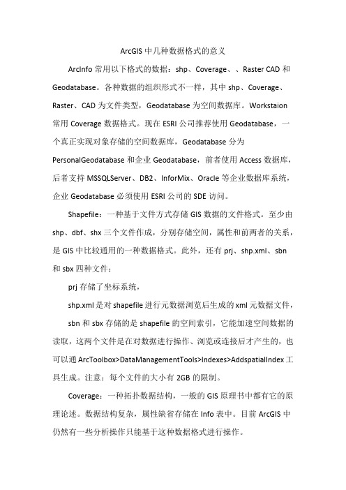
ArcGIS中几种数据格式的意义ArcInfo常用以下格式的数据:shp、Coverage、、Raster CAD和Geodatabase。
各种数据的组织形式不一样,其中shp、Coverage、Raster、CAD为文件类型,Geodatabase为空间数据库。
Workstaion常用Coverage数据格式。
现在ESRI公司推荐使用Geodatabase,一个真正实现对象存储的空间数据库,Geodatabase分为PersonalGeodatabase和企业Geodatabase,前者使用Access数据库,后者支持MSSQLServer、DB2、InforMix、Oracle等企业数据库系统,企业Geodatabase必须使用ESRI公司的SDE访问。
Shapefile:一种基于文件方式存储GIS数据的文件格式。
至少由shp、dbf、shx三个文件作成,分别存储空间,属性和前两者的关系,是GIS中比较通用的一种数据格式。
此外,还有prj、shp.xml、sbn和sbx四种文件:prj存储了坐标系统,shp.xml是对shapefile进行元数据浏览后生成的xml元数据文件,sbn和sbx存储的是shapefile的空间索引,它能加速空间数据的读取,这两个文件是在对数据进行操作、浏览或连接后才产生的,也可以通ArcToolbox>DataManagementTools>Indexes>AddspatialIndex工具生成。
注意:每个文件的大小有2GB的限制。
Coverage:一种拓扑数据结构,一般的GIS原理书中都有它的原理论述。
数据结构复杂,属性缺省存储在Info表中。
目前ArcGIS中仍然有一些分析操作只能基于这种数据格式进行操作。
Geodatabase:ArcInfo发展到ArcGIS时候推出的一种数据格式,一种基于RDBMS存储的数据格式,其有两大类:1、PersonalGeodatabse用来存储小数据量数据,存储在Access的mdb 格式中,文件不能大于4GB。
arcgis kmz格式

arcgis kmz格式什么是ArcGIS KMZ格式?ArcGIS KMZ格式是一种地理信息系统(GIS)中常用的文件格式,可用于在Google Earth和Google Maps等平台上共享地理数据和地图。
KMZ 代表Keyhole Markup Language Zipped,是一种基于XML的数据格式,具有压缩功能,可以通过将一个或多个几何、文本和图像文件打包到单个文件中来减少文件大小。
ArcGIS是一套强大的GIS软件,能够处理、管理和分析各种类型的地理数据。
KMZ格式则使ArcGIS用户能够将他们的地图和数据在Google Earth和Google Maps上展示和共享。
使用ArcGIS软件,用户可以创建、编辑和导出KMZ文件,以便其他人可以在Google Earth和Google Maps中查看和交互式浏览这些地理数据。
如何创建ArcGIS KMZ文件?创建ArcGIS KMZ文件的第一步是确保已经安装和打开了ArcGIS软件。
然后,按照以下步骤进行操作:步骤1:准备数据在创建KMZ文件之前,必须先准备好要显示在Google Earth或GoogleMaps上的地理数据。
这可以包括矢量数据、栅格数据、属性数据等。
确保这些数据已经整理和组织好,并导入到ArcGIS软件中。
步骤2:创建地图使用ArcGIS软件的地图编辑和设计功能,创建一个您想要在KMZ文件中显示的地图。
可以选择添加地理要素、更改地图符号、调整图层排列等等。
确保地图设计符合您展示的目的和主题。
步骤3:导出为KMZ文件当地图准备完成后,可以将其导出为KMZ文件。
选择“文件”菜单,然后选择“导出地图”。
在弹出的对话框中,选择“KMZ”作为要导出的文件类型。
步骤4:设定导出选项在导出选项中,可以选择包括哪些要素和图层以及如何显示。
可以选择导出整个地图,或只是选择其中的一部分。
您还可以选择压缩选项,以减小生成的KMZ文件的大小。
ArcGIS地理信息系统三大文件格式解析
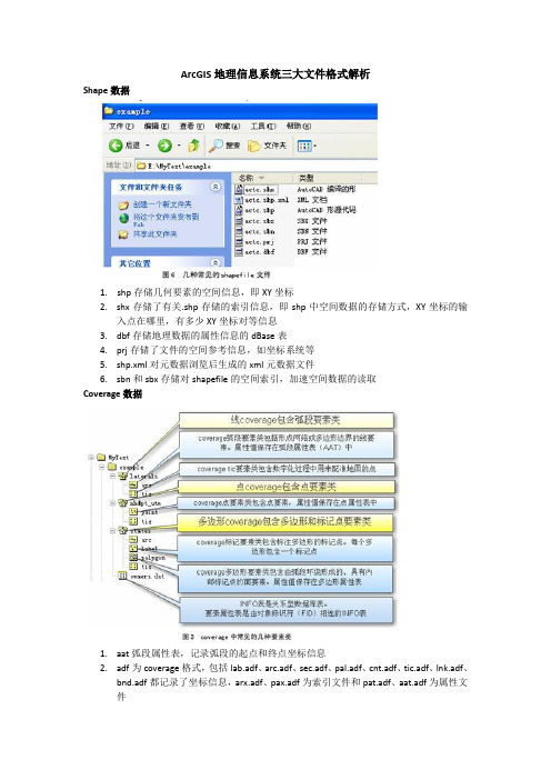
ArcGIS地理信息系统三大文件格式解析Shape数据1. shp存储几何要素的空间信息,即XY坐标2.shx存储了有关.shp存储的索引信息,即shp中空间数据的存储方式,XY坐标的输入点在哪里,有多少XY坐标对等信息3.dbf存储地理数据的属性信息的dBase表4.prj存储了文件的空间参考信息,如坐标系统等5.shp.xml对元数据浏览后生成的xml元数据文件6.sbn和sbx存储对shapefile的空间索引,加速空间数据的读取Coverage数据1.aat弧段属性表,记录弧段的起点和终点坐标信息2.adf为coverage格式,包括lab.adf、arc.adf、sec.adf、pal.adf、cnt.adf、tic.adf、lnk.adf、bnd.adf都记录了坐标信息,arx.adf、pax.adf为索引文件和pat.adf、aat.adf为属性文件3.pat点属性表,记录lable点的坐标信息4.tic控制点,用于配准地图的点5.aux保存栅格文件自身不能保存的辅助信息,包括彩色地图信息,直方图或表格,坐标系统,变换信息,投影信息6.rrd保存影像金字塔信息索引,加速显示和漫游7.dat属性信息8.nit属性表定义文件9.dir属性表路径管理文件,用于关联dat和nitGeodatabase数据∙adf - ARC/INFO coverage data file∙agf - Atlas GIS native binary geodataset file∙ain - attribute index file∙aih - attribute index file∙alg - ER Mapper algorithm∙apr - ArcView Project File (ODB format)∙avl - legend template file (ODB format)∙avp - palette file (ODB format)∙ave - Avenue script∙avx - ArcView extension file (ODB format)∙ai - Adobe Illlustrator picture file∙bat - DOS batch file∙bil - image file (band interleaved by line)∙bip - image file (band interleaved by pixel)∙blw - world file for bil image∙bmp - Windows bitmap image file∙bpw - world file for bip or bmp images∙bsq - image file (band sequential)∙bqw - world file for bsq image∙ c - C programming language source code filename∙cat - UNIX hyperhelp supporting file∙cgm - Computer Graphics Metafile∙cls - geocoding classification file∙cnt - help file contents∙dat - generic data file extension dat - INFO attribute file∙db - Object Database File (also ODB)∙dbf - dBASE tabular data file∙dbf - Shapefile attribute table file∙dbg - problem debug log file∙dcp - default codepage file∙dct - geocoding dictionary file∙dec - UNIX hyperhelp supporting file∙def - defaults file (North Arrows, Layout Templates, etc) (ODB format) ∙dem - Digital Elevation Model file∙dgn - Design drawing file (Intergraph)∙dir - INFO directory manager file∙dlg - Digital Line Graph file∙dll - Windows Dynamic Link Library file∙doc - MS-Word, MS-Wordpad document file∙dtd - UNIX hyperhelp supporting file∙dwg - Drawing file (AutoCAD)∙dxf - Drawing exchange file∙e00 - ARC/INFO export file∙ecw - ER Mapper Enhanced Compressed Wavelet∙eps - Encapsulated PostScript∙ers - ER Mapper raster file format∙exe - DOS/Windows executable file∙fbn - spatial index file for read-only datasets∙fbx - spatial index file for read-only datasets∙fls - Windows help supporting file∙ftg - UNIX help supporting file∙fts - UNIX help supporting file∙gen - ARC/INFO UnGenerate format∙gfw - world file for gif image∙gif - image file (CompuServe)∙hdr - header file (for ArcView extensions or TIF images)∙hlp - Windows help file∙htm - WWW file (hypertext markup, 3-character DOS version)∙html- WWW file (hypertext markup language, UNIX version)∙ico - Icon file∙idx - geocoding index for read-only datasets∙img - ERDAS Imagine image file∙ini - initialization file∙ixc - geocoding index for read-write coverages∙ixs - geocoding index for read-write shapefiles∙jpg - image file (Joint Photographic Experts Group)∙key - geocoding matching keys (ODB format)∙lin - ARC/INFO lineset symbol file∙lnk - Windows shortcut icon link file∙mat - geocoding matching parameters file∙mcp - image file (MacPaint)∙mid - MapInfo interchange format (always paired with "mif")∙mif - MapInfo interchange format (always paired with "mid")∙mrk - ARC/INFO markerset symbol file (not compatible w/ArcView) ∙mxc - geocoding index for read-write coverages (ODB format)∙mxs - geocoding index for read-write shapefiles (ODB format)∙nit - INFO table definitions file∙ndx - fonts index file (UNIX only)∙nls - Codepage language files∙odb - Object Database ASCII file (ODB format)∙pat - geocoding pattern recognition file∙pdf - preferences definition file∙pif - Windows program information file (for DOS programs)∙pps - processing set codes∙prj - projections definition file∙ps - PostScript. file∙rlc - image file (run-length coding)∙rs - image file (raster snapshot | Sun rasterfile)∙sbn - spatial index for read-write shapefiles∙sbx - spatial index for read-write shapefiles∙shd - ARC/INFO shadeset symbol file∙shp - Shapefile (stores feature geometry)∙shx - Shapefile (stores file lookup index)∙stn - geocoding standardization file∙tab - lookup file∙tbl - geocoding support table∙tif - image file (Tag Image Format file)∙tfw - world file for tif image∙tmp - temporary file∙ttf - TrueType font file∙txt - text file (usually ASCII)∙xbm - image file (X Bitmap)∙wmf - image file (Windows Metafile)∙wld - world file for CAD datasets∙wri - Windows Write.exe file。
arcgis-shp文件的组成

arcgis shp文件的组成
ArcGIS中的SHP文件是一种常见的地理数据格式,它由多个文件组成。
一个完整的SHP文件通常由三个文件组成,分别具有以下扩展名:
1. `.shp`(Shapefile):这是SHP文件的核心文件,包含几何图形和属性数据。
它存储了点、线、多边形等地理要素的几何信息。
2. `.shx`(Shapefile Index):这是SHP文件的索引文件,用于加快对SHP 文件的读取速度。
它存储了几何图形的位置和偏移量,方便在SHP文件中快速查找和访问特定的要素。
3. `.dbf`(dBASE File):这是SHP文件的属性数据文件,以dBASE格式存储。
它包含与几何图形相关联的属性数据,如名称、值等。
属性数据与几何数据之间通过记录索引进行关联。
除了这三个基本的文件,SHP文件还可能包含其他附加文件,如:
- `.prj`(Projection):这是空间参考文件,定义了地理数据的坐标系和投影信息。
- `.sbn` 和`.sbx`:这些是空间索引文件,用于提高SHP文件的查询性能。
- `.shm` 和 `.shp.xml`:这些是SHP文件的内部使用文件,包含了元数据信息、编辑历史等。
需要注意的是,SHP文件只能存储单一类型的几何要素(例如点、线或多边形)。
如果想要存储多个不同类型的几何要素,可以使用多个SHP文件或者使用GIS数据格式如File Geodatabase。
希望以上信息对你理解ArcGIS SHP文件的组成有所帮助。
如有其他问题,请随时提问。
ArcGIS中文件扩展名的含义
img - ERDAS Imagine image file
ini - initialization file
ixc - geocoding index for read-write coverages
mif - MapInfo interchange format (always paired with "mid")
mrk - ARC/INFO markerset symbol file (not compatible w/ArcView)
mxc - geocoding index for read-write coverages (ODB format)
wld - world file for CAD datasets
wri - Windows Write.exe file
hlp - Windows help file
htm - WWW file (hypertext markup, 3-character DOS version)
html- WWW file (hypertext markup language, UNIX version)
ico DOS batch file
bil - image file (band interleaved by line)
bip - image file (band interleaved by pixel)
blw - world file for bil image
bmp - Windows bitmap image file
ixs - geocoding index for read-write shapefiles
ArcGIS 文件格式说明

1、rrd/auxArcGIS中的辅助(auxiliary)文件--扩展名为AUX,是一个用来保存栅格文件自身不能保存的辅助信息的文件,它与栅格文件一起存在同一目录中,文件名与栅格文件一致。
一个栅格数据集的统计信息如果不能保存在自身的栅格文件中,那这些信息就会保存在对应的AUX文件中。
AUX在对栅格图层进行第一次统计分析的时候自动创建。
如果栅格数据集很大,因为统计分析就需要获取更多的栅格单元,以得到统计结果,那么生成AUX文件的时间也需要长些。
AUX文件一旦创建好之后,在以后的生产中,如果需要对应栅格数据集的统计信息,那么就可以直接利用AUX文件中的统计数据了,而不需要重新进行统计运算。
如果一个栅格数据集已经创建了影像金字塔,那么AUX文件也保存影像金字塔(RRD)文件保存路径的指针。
在影像金字塔创建好之后,直接利用操作系统的Copy、Cut命令来移动栅格图层(raster),系统软件就会在AUX文件中记录的路径中寻找RRD 文件。
如果找不到对应的RRD文件,系统则会在栅格文件移动前的目录下寻找RRD文件。
如果要赋值或粘贴一个栅格数据集,所以为了保住相关文件的完整,最好使用ArcCatalog或ArcInfo实现,AUX文件能够保存以下信息:彩色地图信息;直方图或表格;坐标系统;变换信息;投影信息。
如果用户是对栅格数据集所在目录或栅格数据集本身进行读写,那么AUX文件会在源数据集的目录下创建。
如果栅格数据集所在文件夹是“只读”,或是栅格数据本身是“只读”,那么AUX文件则会创建在默认的代理文件(proxyfile)路径下。
AUX文件存储的信息,只能由ESRI产品,ERDS或是由RDO/ERaster 库派生出的第三方产品读取。
ArcGIS的一些名词解释-推荐下载

【ESRI】ArcGIS的一些名词解释AML宏语言AML是在ARC环境中用于编程和创建应用的语言。
AML提供完整的编程能力和一套工具来创建应用的用户界面。
叠置分析是把两层和多层地图要素叠加产生一个新图层的操作。
叠置分析可以应用于矢量图层的叠置、栅格GRID的叠加以及地理事件的叠加等。
区域查询是从多个图层中查询满足一定条件的特征,从而创建一个新的图层的空间分析操作。
该工具也可以创建满足条件的区域子类。
ArcGIS Desktop是一个集成了众多高级GIS应用的软件套件,它包含了一套带有用户界面组件的Windows桌面应用(例如,ArcMap,ArcCatalog,ArcToobox)。
ArcSDE是在各种关系型数据库管理系统中管理地理信息的高级空间数据服务器。
ArcIMS是通过开放的Internet协议发布地图、数据和元数据的可伸缩的网络地图服务器。
ArcMap 是一个用于编辑、显示、查询和分析地图数据的以地图为核心的模块,ArcMap包含一个复杂的专业制图和编辑系统,既是一个面向对象的编辑器,又是一个完整的数据表生成器。
ArcCatalog 是以数据为核心,用于定位、浏览和管理空间数据的模块,是用户规划数据表,用于制定和利用元数据的环境,应用模块帮助你组织和管理你所有的GIS 信息,比如地图,数据集,模型,元数据,服务等。
ARCTOOLBOX是用于完成ARCGIS所提供的数据转换、叠加处理、缓冲区生成和投影变换等空间数据分析的处理环境。
MapObjects是一组供应用开发人员使用的制图与GIS功能组件。
它由一个OLE控件和一系列可编程OLE对象组成。
利用MapObjects,开发人员可以在应用程序中添加制图和GIS功能。
ArcGIS Engine是一个完整的嵌入式GIS组件库和工具包,开发者能用它创建一个新的、或扩展原有的可定制的桌面应用程序。
ArcGIS Server是一个中心应用服务器,它包含一个可共享的GIS软件对象库,能在企业和Web计算框架中建立服务器端的GIS应用。
arcgis mdb格式

arcgis mdb格式
ArcGIS是一款由Esri开发的地理信息系统(GIS)软件,而MDB格式则是一种由Microsoft Access数据库管理系统使用的数据库文件格式。
在ArcGIS中,MDB格式通常用来存储地理空间数据和相关的属性数据。
这种格式可以用来创建和管理地理数据库,包括点、线、面等地理要素的空间数据以及这些要素的属性信息。
MDB格式在ArcGIS中的应用主要体现在以下几个方面:
1. 存储地理空间数据,MDB格式可以存储各种地理要素的空间数据,包括点、线、面等,这些数据可以用来创建地图、进行空间分析等。
2. 存储属性数据,除了空间数据,MDB格式还可以存储与地理要素相关的属性数据,例如地块所有者、土地用途等信息。
3. 数据管理,ArcGIS可以通过MDB格式对地理数据库进行管理,包括数据的导入、导出、编辑等操作。
4. 与其他GIS软件的兼容性,MDB格式是一种通用的数据库文
件格式,在一定程度上与其他GIS软件兼容,可以方便地进行数据
共享和交换。
需要注意的是,MDB格式虽然在过去被广泛应用,但由于其一
些限制和安全性等方面的考虑,Esri已经逐渐推荐用户使用更现代
的数据库格式,如File Geodatabase(GDB)等。
因此,在使用ArcGIS时,建议根据具体需求和实际情况选择合适的数据存储格式。
ArcGIS各类型的文件的解释

ArcGIS各类型的文件的解释ArcGIS问题:dbf shp shx sbn sbx mdb adf等类型的文件的解释这些文件英文解释如下(看不懂可以看下面的中文解释):Shapefile file extensionsshp—The main file that stores the feature geometry. Required..shx—The index file that stores the index of the feature geometry. Required..dbf—The dBASE table that stores the attribute information of features.Required.There is a one-to-one relationship between geometry and attributes, which isbased on record number. Attribute records in the dBASE file must be in thesame order as records in the main file..sbn and .sbx—The files that store the spatial index of the features..fbn and .fbx—The files that store the spatial index of the features forshapefiles that are read-only..ain and .aih—The files that store the attribute index of the active fields ina table or a theme's attribute table..atx—An .atx file is created for each shapefile or dBASE attribute indexcreated in ArcCatalog. ArcView GIS 3.x attribute indexes for shapefiles anddBASE files are not used by ArcGIS. A new attribute indexing model has beendeveloped for shapefiles and dBASE files..ixs—Geocoding index for read-write shapefiles..mxs—Geocoding index for read-write shapefiles (ODB format)..prj—The file that stores the coordinate system information. Used by ArcGIS..xml—Metadata for ArcGIS—stores information about the shapefile.中文解释呢:shapefile文件属于矢量数据中无拓扑关系的数据类型。
arcgis栅格文件后缀

arcgis栅格文件后缀
ArcGIS栅格文件通常有不同的后缀,这些后缀用于区分不同类型的栅格数据。
以下是一些常见的ArcGIS栅格文件后缀及其含义:
1..tif或.tiff:
-表示GeoTIFF格式的栅格文件,它包含地理空间信息,适用于保存地理参考的栅格数据。
2..img:
-表示ERDAS IMAGINE格式的栅格文件,这是一种广泛用于遥感图像处理的格式。
3..grd:
-表示ESRI栅格格式的栅格文件,是ArcGIS中常见的栅格数据格式。
4..asc:
-表示ASCII栅格格式的栅格文件,它使用文本文件存储栅格数据。
5..adf:
-表示ArcGIS栅格数据集格式,通常是一组相关的栅格数据组织在一起的格式。
6..bil、.bip、.bsq:
-这些是二进制栅格文件的不同存储方式,分别表示按行、按像元和按平面存储。
这只是一些常见的栅格文件后缀,具体的后缀可能会根据数据类型和格式而有所不同。
Arcgis中有关数据类型及数据格式的说明

Arcgis中有关数据类型及数据格式的说明1、地图模板(A template)文件.mxt2、在arcmap地图中,显示的数据类型各不相同,有栅格、矢量、表格,并且以不同的形式保存,如果数据以arcmap支持的格式保存,可以直接将它作为数据层添加到地图中,如果数据是以Arcmap不支持的格式储存,可以用ArcToolBox的数据格式转换工具来转换并显示到地图上。
A、加载Coverage数据源。
Coverage数据由两个文件夹组成:一个文件夹用于存储空间几何信息,该文件夹的名称就是这个Coverage数据的名称;另一个文件夹饿名字是info,它存储的是Coverage的属性信息。
加载时选择states文件图标。
B、加载shapefile数据。
Shapefile文件用来存储一个数据集中有关空间要素的无拓扑的几何和属性信息。
Shapefile主要由三种格式的文件组成:.dbf数据库文件,用于保存GIS数据中的属性信息;.SHP用于保存GIS数据中的空间信息;.SHX索引文件,连接shapefile文件的空间信息和属性信息。
注意加载时选择.SHP文件图标。
C、加载Geodatebase数据。
Geodatebase是Arcinfo8引入的一种全新的面向对象的空间数据模型,是建立在DBMS之上的统一的、智能的空间数据模型。
按其所存储的数据产品类型进行划分,空间数据库包括矢量数据、数字高程模型、数字正射影像、数字栅格地图以及对这些数据进行说明的元数据,最后还包括专题数据。
加载时选择.mdb文件图标。
D、AutoCAD数据的加载。
Arcmap可以直接读取autoCAD矢量数据,所以无需进行任何数据格式转换操作。
不过在Arcmap看来autoCAD矢量数据由两部分组成,一部分是图形数据(CADdrawing),另一部分是属性数据(CADfeatures)。
如果只是为了浏览CAD图形数据,那么只需加载其中的图形数据就可以,而如果是为了进行空间分析,那么就就必须加载属性数据,所以分两种情况进行数据加载:(1)加载autoCAD图形数据。
ArcGIS的一些名词解释

【ESRI】ArcGIS的一些名词解释AML宏语言AML是在ARC环境中用于编程和创建应用的语言。
AML提供完整的编程能力和一套工具来创建应用的用户界面。
叠置分析是把两层和多层地图要素叠加产生一个新图层的操作。
叠置分析可以应用于矢量图层的叠置、栅格GRID的叠加以及地理事件的叠加等。
区域查询是从多个图层中查询满足一定条件的特征,从而创建一个新的图层的空间分析操作。
该工具也可以创建满足条件的区域子类。
ArcGIS Desktop是一个集成了众多高级GIS应用的软件套件,它包含了一套带有用户界面组件的Windows桌面应用(例如,ArcMap,ArcCatalog,ArcToobox)。
ArcSDE是在各种关系型数据库管理系统中管理地理信息的高级空间数据服务器。
ArcIMS是通过开放的Internet协议发布地图、数据和元数据的可伸缩的网络地图服务器。
ArcMap 是一个用于编辑、显示、查询和分析地图数据的以地图为核心的模块,ArcMap包含一个复杂的专业制图和编辑系统,既是一个面向对象的编辑器,又是一个完整的数据表生成器。
ArcCatalog 是以数据为核心,用于定位、浏览和管理空间数据的模块,是用户规划数据表,用于制定和利用元数据的环境,应用模块帮助你组织和管理你所有的GIS 信息,比如地图,数据集,模型,元数据,服务等。
ARCTOOLBOX是用于完成ARCGIS所提供的数据转换、叠加处理、缓冲区生成和投影变换等空间数据分析的处理环境。
MapObjects是一组供应用开发人员使用的制图与GIS功能组件。
它由一个OLE控件和一系列可编程OLE对象组成。
利用MapObjects,开发人员可以在应用程序中添加制图和GIS功能。
ArcGIS Engine是一个完整的嵌入式GIS组件库和工具包,开发者能用它创建一个新的、或扩展原有的可定制的桌面应用程序。
ArcGIS Server是一个中心应用服务器,它包含一个可共享的GIS软件对象库,能在企业和Web计算框架中建立服务器端的GIS应用。
- 1、下载文档前请自行甄别文档内容的完整性,平台不提供额外的编辑、内容补充、找答案等附加服务。
- 2、"仅部分预览"的文档,不可在线预览部分如存在完整性等问题,可反馈申请退款(可完整预览的文档不适用该条件!)。
- 3、如文档侵犯您的权益,请联系客服反馈,我们会尽快为您处理(人工客服工作时间:9:00-18:30)。
agf - Atlas GIS native binary geodataset file
ain - attribute index file
aih - attribute index file
alg - ER Mapper algorithm
apr - ArcView Project File (ODB format)
avl - legend template file (ODB format)
avp - palette file (ODB format)
ave - Avenue script
avx - ArcView extension file (ODB format)
ai - Adobe Illlustrator picture file
bat - DOS batch file
bil - image file (band interleaved by line)
bip - image file (band interleaved by pixel)
blw - world file for bil image
bmp - Windows bitmap image file
bpw - world file for bip or bmp images
bsq - image file (band sequential)
bqw - world file for bsq image
c - C programming language source code filename
cat - UNIX hyperhelp supporting file
cgm - Computer Graphics Metafile
cls - geocoding classification file
cnt - help file contents
dat - generic data file extension dat - INFO attribute file
db - Object Database File (also ODB)
dbf - dBASE tabular data file
dbf - Shapefile attribute table file
dbg - problem debug log file
dcp - default codepage file
dct - geocoding dictionary file
dec - UNIX hyperhelp supporting file
def - defaults file (North Arrows, Layout Templates, etc) (ODB format) dem - Digital Elevation Model file
dgn - Design drawing file (Intergraph)
dir - INFO directory manager file
dlg - Digital Line Graph file
dll - Windows Dynamic Link Library file
doc - MS-Word, MS-Wordpad document file
dtd - UNIX hyperhelp supporting file
dwg - Drawing file (AutoCAD)
dxf - Drawing exchange file
e00 - ARC/INFO export file
ecw - ER Mapper Enhanced Compressed Wavelet
eps - Encapsulated PostScript
ers - ER Mapper raster file format
exe - DOS/Windows executable file
fbn - spatial index file for read-only datasets
fbx - spatial index file for read-only datasets
fls - Windows help supporting file
ftg - UNIX help supporting file
fts - UNIX help supporting file
gen - ARC/INFO UnGenerate format
gfw - world file for gif image
gif - image file (CompuServe)
hdr - header file (for ArcView extensions or TIF images)
hlp - Windows help file
htm - WWW file (hypertext markup, 3-character DOS version)
html- WWW file (hypertext markup language, UNIX version)
ico - Icon file
idx - geocoding index for read-only datasets
img - ERDAS Imagine image file
ini - initialization file
ixc - geocoding index for read-write coverages
ixs - geocoding index for read-write shapefiles
jpg - image file (Joint Photographic Experts Group)
key - geocoding matching keys (ODB format)
lin - ARC/INFO lineset symbol file
lnk - Windows shortcut icon link file
mat - geocoding matching parameters file
mcp - image file (MacPaint)
mid - MapInfo interchange format (always paired with "mif")
mif - MapInfo interchange format (always paired with "mid")
mrk - ARC/INFO markerset symbol file (not compatible w/ArcView) mxc - geocoding index for read-write coverages (ODB format) mxs - geocoding index for read-write shapefiles (ODB format)
nit - INFO table definitions file
ndx - fonts index file (UNIX only)
nls - Codepage language files
odb - Object Database ASCII file (ODB format)
pat - geocoding pattern recognition file
pdf - preferences definition file
pif - Windows program information file (for DOS programs)
pps - processing set codes
prj - projections definition file
ps - PostScript file
rlc - image file (run-length coding)
rs - image file (raster snapshot | Sun rasterfile)
sbn - spatial index for read-write shapefiles
sbx - spatial index for read-write shapefiles shd - ARC/INFO shadeset symbol file
shp - Shapefile (stores feature geometry)
shx - Shapefile (stores file lookup index) stn - geocoding standardization file
tab - lookup file
tbl - geocoding support table
tif - image file (Tag Image Format file)
tfw - world file for tif image
tmp - temporary file
ttf - TrueType font file
txt - text file (usually ASCII)
xbm - image file (X Bitmap)
wmf - image file (Windows Metafile)
wld - world file for CAD datasets
wri - Windows Write.exe file。