Carbon and Water Tradeoffs in Conversions to Forests and Shrublands 237-246
森林生态系统碳储量估算方法研究进展_程鹏飞

· 40·
林业调查规划
第 34卷
按照区域或国家尺度土壤图上的面积得到碳蓄积总
量 .同时 , 还可以在土壤图上将土壤单元与土壤碳密 度匹配以表现土壤碳蓄积量的空间分布特征 .土壤 类型法也可以利用世界土壤图和全球土壤分类系统 形 成 统 一 估 算 体 系 来 估 算 全 球 碳 蓄 积 量 [ 4] . Franzmeier等人[ 5] 就利用美国中西部 地区 12个州 的 1∶250万的土壤分布图 , 估算了所研究区域的土 壤有机碳 储 量 .Batjes[ 6] 按 经 纬 度 将 全 球 划分 为 259 200个土壤面积单元 , 根 据每个土种分布 、土壤 深度 、土壤容重 、有机碳及砾石含量等数据 , 求出每 个面积单元的土壤平均碳密度 , 最后求和得出全球 的土壤有机碳总 量 .此方 法原理简单 , 数据较易获 取 , 是目前国内外土壤碳储量估算的最常用方法 , 但 土壤类型法需具备详细的各类土壤理化性质数据 , 否则估算精度不高 .未来此方法的研究应采用更详 细 、更准确的土壤类型分布图和土壤属性信息 , 以提 高估测精度 [ 7] . 1.2 生命带研究方法
生物量与蓄积量为基础的地上植物碳储量估算方法能够用于长时期大面积的森林碳储量监测但其不足在于消耗劳动力多并且只能问歇地记录碳储量不能反映出季节和年变化的动态效应同时由于各地区研究的层次时间尺度空间范围和精细程度不同及样地的设置估测的方法等各异使研究结果的可靠性和可比性较差
第 34卷 2009年
第 6期 12月
10倍之多 , 森林碳库发生细微的变化就会对全球气 候系统产生巨 大的影响 [ 1] .因此 , 准 确地估算森林 生态系统碳储量及其变动引起的全球陆地生态系统
碳储量变化受到科学家们的普遍关注 . 森林生态系统碳储量包括土壤碳库 、植被碳库
中国森林生态系统的植物碳储量和碳密度研究
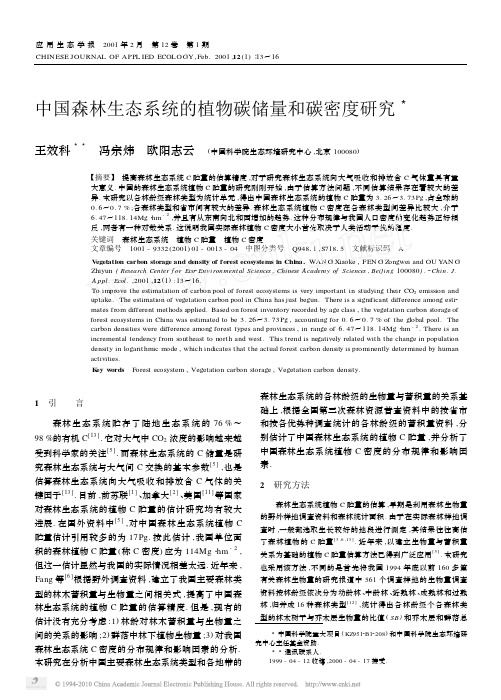
中国森林生态系统的植物碳储量和碳密度研究3王效科33 冯宗炜 欧阳志云 (中国科学院生态环境研究中心,北京100080)【摘要】 提高森林生态系统C 贮量的估算精度,对于研究森林生态系统向大气吸收和排放含C 气体量具有重大意义.中国的森林生态系统植物C 贮量的研究刚刚开始,由于估算方法问题,不同估算结果存在着较大的差异.本研究以各林龄级森林类型为统计单元,得出中国森林生态系统的植物C 贮量为3.26~3.73Pg ,占全球的0.6~0.7%;各森林类型和省市间有较大的差异.森林生态系统植物C 密度在各森林类型间差异比较大,介于6.47~118.14Mg ・hm -2,并且有从东南向北和西增加的趋势.这种分布规律与我国人口密度的变化趋势正好相反,两者有一种对数关系.这说明我国实际森林植物C 密度大小首先取决于人类活动干扰的程度.关键词 森林生态系统 植物C 贮量 植物C 密度文章编号 1001-9332(2001)01-0013-04 中图分类号 Q94811,S71815 文献标识码 AV egetation carbon storage and density of forest ecosystems in China.WAN G Xiaoke ,FEN G Z ongwei and OU Y AN G Zhiyun (Research Center f or Eco 2Environmental Sciences ,Chinese Academy of Sciences ,Beijing 100080).2Chin.J.A ppl.Ecol .,2001,12(1):13~16.To improve the estimatation of carbon pool of forest ecosystems is very important in studying their CO 2emission and uptake.The estimation of vegetation carbon pool in China has just begun.There is a significant difference among esti 2mates from different methods applied.Based on forest inventory recorded by age class ,the vegetation carbon storage of forest ecosystems in China was estimated to be 3.26~3.73Pg ,accounting for 0.6~0.7%of the global pool.The carbon densities were difference among forest types and provinces ,in range of 6.47~118.14Mg ・hm -2.There is an incremental tendency from southeast to north and west.This trend is negatively related with the change in population density in logarithmic mode ,which indicates that the actual forest carbon density is prominently determined by human activities.K ey w ords Forest ecosystem ,Vegetation carbon storage ,Vegetation carbon density. 3中国科学院重大项目(KZ9512B12208)和中国科学院生态环境研究中心主任基金资助. 33通讯联系人. 1999-04-12收稿,2000-04-17接受.1 引 言森林生态系统贮存了陆地生态系统的76%~98%的有机C [13].它对大气中CO 2浓度的影响越来越受到科学家的关注[5].而森林生态系统的C 储量是研究森林生态系统与大气间C 交换的基本参数[5],也是估算森林生态系统向大气吸收和排放含C 气体的关键因子[13].目前,前苏联[1]、加拿大[2]、美国[11]等国家对森林生态系统的植物C 贮量的估计研究均有较大进展.在国外资料中[5],对中国森林生态系统植物C 贮量估计引用较多的为17Pg.按此估计,我国单位面积的森林植物C 贮量(称C 密度)应为114Mg ・hm -2,但这一估计显然与我国的实际情况相差太远.近年来,Fang 等[6]根据野外调查资料,建立了我国主要森林类型的林木蓄积量与生物量之间相关式,提高了中国森林生态系统的植物C 贮量的估算精度.但是,现有的估计没有充分考虑:1)林龄对林木蓄积量与生物量之间的关系的影响;2)群落中林下植物生物量;3)对我国森林生态系统C 密度的分布规律和影响因素的分析.本研究在分析中国主要森林生态系统类型和各地带的森林生态系统的各林龄级的生物量与蓄积量的关系基础上,根据全国第三次森林资源普查资料中的按省市和按各优势种调查统计的各林龄级的蓄积量资料,分别估计了中国森林生态系统的植物C 贮量,并分析了中国森林生态系统植物C 密度的分布规律和影响因素.2 研究方法森林生态系统植物C 贮量的估算,早期是利用森林生物量的野外样地调查资料和森林统计面积.由于在实际森林样地调查时,一般都选取生长较好的地段进行测定,其结果往往高估了森林植物的C 贮量[3,6,13].近年来,以建立生物量与蓄积量关系为基础的植物C 贮量估算方法已得到广泛应用[5].本研究也采用该方法,不同的是首先将我国1994年底以前160多篇有关森林生物量的研究报道中561个调查样地的生物量调查资料按林龄级依次分为幼龄林、中龄林、近熟林、成熟林和过熟林,归并成16种森林类型[12],统计得出各林龄级个各森林类型的林木树干与乔木层生物量的比值(SB )和乔木层和群落总应用生态学报 2001年2月 第12卷 第1期 CHIN ESE JOURNAL OF APPL IED ECOLO GY ,Feb.2001,12(1)∶13~16生物量(包括林下所有植物的生物量)的比值(B T),然后再将这些森林类型归并为中国森林资源普查的统计单元:森林优势种类型和省市[12].利用下式,可得出中国各类型和各省市(台湾除外)的森林植物C贮量(TC,Tg):TC=V×D×SB×B T×(1+TD)×Cc(1)式中,V是某一森林类型或省市的森林蓄积量(m3),来自林业部第三次全国森林资源普查资料;D是树干密度(Mg・m-3),采用中国林业科学研究院木材工业研究所的研究结果[8].Cc是植物中C含量,该值在不同植物间变化不大,因此,为简便起见,常采用0.45[4].然后统计中国森林生态系统的总植物C贮量.并进一步分析各类型和各省市的C密度差异和影响因素,并用地理信息系统Arc/View做出中国森林植物C密度分布图,建立了中国各省市森林植物C密度与人口密度间的关系.3 结果与讨论311 各森林类型植物C贮量和C密度根据中国38种优势种森林的蓄积量估算出,中国森林生态系统的植物C总贮量是3724.50Tg(表1).从林龄级分布看,幼龄林、中龄林、近熟林、成熟林和过熟林分别占14.6、29.7、12.0、29.5和1412%.从类型构成看,栎类林最大,占2214%(这是因为栎类在我国分布的面积较大),其次为落叶松林,占12.1%,阔叶混交林占11.5%.由图1可以看出,各森林类型的植物C密度差异较大,介于6.47~118.14Mg・hm-2.云杉林、冷杉林、高山松和热带林的植物C密度较高,>60Mg・hm-2.而黑松林、油松林、马尾松林、杉木林、柳杉林、水杉林和桉树林的植物C密度较小,<15Mg・hm-2.这主要是由于林龄差异造成的,云杉林、冷杉林、高山松和热带林中,成熟林和过熟林占的比例较大,黑松林、油松林、马尾松林、杉木林、柳杉林、水杉林和桉树林中,人工林占的比例较大,多为幼、中龄林.312 各省市的森林植物C贮量和C密度根据中国30个省市地区的针叶林和阔叶林蓄积量资料,估计出中国森林生态系统的植物C总贮量是3255171Tg(表2).从林龄级的分布看,幼龄林、中龄林、近熟林、成熟林和过熟林分别占14.3、30.6、11.4、2917和14.0%.与以上结果基本一致.从各省市的构成看,黑龙江省最大,占17.7%,其次为四川和云南省,分别占15.4%和1410%,内蒙古自治区占11.6%. 从图2可见,中国森林生态系统的植物C密度有从东南向东北和西增加的趋势.我国森林植物C密度较高的省份为黑龙江、吉林、西藏和海南,<5311Mg・hm-2.尽管西藏的森林面积很小,但现存森林的植物C密度很高,如西藏的雅鲁藏布江的大拐弯处是我国表1 中国各森林生态系统的总生物质C贮量T able1V egetation carbon storage of every forest ecosystems in China(T g)林型F oresttype幼龄林Y oung中龄林Middle2aged近熟林Prema2ture成熟林Mature过熟林Post2mature总计Total比例Percen2tage1 3.12 4.85 4.3214.30 1.7928.380.762 1.7125.2633.80140.28113.38314.438.443 5.8135.8019.70235.8633.00330.178.86 40.70 2.13 2.7210.319.6525.510.68 57.847.17 1.508.59 2.1527.250.73 690.11101.9057.39142.8757.91450.1812.09 7 3.85 5.88 1.20 4.570.0015.500.42 80.010.090.020.000.000.120.00 90.160.050.000.000.000.210.01 10 5.3810.50 2.250.92 1.3620.410.55 110.59 3.71 2.22 1.45 1.499.460.25 120.60 1.340.740.110.73 3.520.09 1342.1267.1418.857.86 2.61138.58 3.72 1421.5724.9812.9024.7726.51110.73 2.9715 4.28 6.72 4.54 6.47 2.9624.970.6716 4.31 5.84 2.5037.568.1358.34 1.57 179.9831.6111.737.50 2.8763.69 1.71 180.030.050.000.250.000.330.01 190.020.060.000.000.000.080.0020 2.6512.34 4.21 6.13 4.5029.830.8021 5.5128.5412.0421.279.3376.69 2.0622 2.257.41 3.27 3.70 1.4518.080.49 230.320.910.140.190.00 1.560.04 240.000.28 1.560.600.45 2.890.08 25163.53281.72108.82180.72101.15835.9422.44 2632.61117.9025.2136.8421.36233.92 6.28 2739.4478.6822.7635.4216.66192.96 5.18 28 2.22 4.32 2.1310.30 2.5521.520.58 290.080.010.030.000.000.120.00 300.550.900.140.300.00 1.890.05 310.150.390.49 1.080.00 2.110.06 3214.9034.2014.6024.2313.03100.96 2.71 330.190.210.020.000.230.650.0234 6.2521.4811.5720.1034.7394.13 2.5335 5.5620.35 2.67 2.450.5531.580.85 3661.13143.0259.97107.3258.33429.7711.54 37 3.6317.52 2.66 3.540.6928.040.75总计543.161105.26448.671097.86529.553724.50100.00 Total11红松Pi nus koraiensis,21冷杉A bies,31云杉Picea,41铁杉Tsuga chi nensis,51柏木Platycladus and Cupressus,61落叶松L ari x,71樟子松Pi nus sylvest ris,81赤松Pi nus densif olia,91黑松Pi nus thunbergii, 101油松Pi nus tabulaef ormis,111华山松Pi nus armandi,121油杉Keteleeria,131马尾松Pi nus massoniana,141云南松Pi nus yunnanen2 sis,151思茅松Pi nus kisiya,161高山松Pi nus densata,171杉木Cun2 ni nghamia lanceolata,181柳杉Cryptomeria f ort unei,191水杉Metase2 quoia glyptost roboi des,201针叶混交林Mixed coniferous,211针阔混交林Mixed coniferous and broad2leaf forest,221水胡黄Fraxi nus,J uglans, Phellodendron,231樟树Ci nnamom um,241楠木Phoebe,251栎类Quercus,261桦木Bet ula,271硬阔类Hardwood,281椴树类Tilia,291檫树S assaf ras tz ume,301桉树Eucalypt us,311木麻黄Casuari na,321杨树Popul us,331桐类Davi dia,341软阔类Softwood,351杂木Acer, Tilia,Ul m us,361阔叶混交林Mixed broad2leaf forest,371热带林Tropic forest.目前森林生物量最高的地方[12].植物C密度较小的省包括广东、广西、湖北、湖南、江西、浙江、江苏、安徽和山东,<12.4Mg・hm-2.森林植物C密度的这种分布规律与我国人口密度的变化趋势正好相反,两者呈显著的对数相关关系(图3),说明我国实际森林植物C 密度大小首先取决于人类活动干扰的程度.可以说人41应 用 生 态 学 报 12卷图1 不同森林生态系统类型的植物C 密度比较Fig.1Comparison of vegetation carbon density among forest ecosystem types.林型同表1.Forest type as table 1.表2 中国各省市森林生态系统的总生物质C 贮量T able 2V egetation carbon storage of every province in China (T g)省 市Province幼龄林Y oung 中龄林Middle 2aged 近熟林Premature 成熟林Mature 过熟林Post 2mature 总 计Total 比 例Percentage 北 京Beijing 1.090.640.110.020.00 1.860.06天 津Tianjin 0.190.260.040.010.000.500.02河 北Hebei 3.8515.00 1.95 1.210.0022.010.68山 西Shanxi 3.4411.31 2.320.790.1117.970.55内蒙古Neimenggu 79.86138.4233.1096.3929.83377.6011.60辽 宁Liaoning 13.1037.27 4.09 3.330.2358.02 1.78吉 林Jilin35.91101.6638.6294.4538.02308.669.48黑龙江Heilongjiang 72.97230.19109.03125.6538.99576.8317.72上 海Shanghai 0.010.000.000.000.000.010.00江 苏Jiangsu 0.560.900.350.090.01 1.910.06浙 江Zhejiang 7.589.28 3.22 3.400.7524.230.74安 徽Anhui 7.6910.27 1.250.690.3620.260.62福 建Fujian 17.0042.677.25 3.70 1.0171.63 2.20江 西Jiangxi 12.3820.86 6.78 4.55 1.3945.96 1.41山 东Shandong 2.27 2.380.000.640.00 5.290.16河 南Henan 7.787.69 1.94 2.280.4520.140.62湖 北Hubei 10.0412.28 2.68 3.48 1.2929.770.91湖 南Hunan 12.5214.16 4.29 6.55 1.2038.72 1.19广 东Guangdong 8.9817.57 5.54 2.090.6334.81 1.07广 西Guangxi 4.4313.0512.0210.6112.7152.82 1.62四 川Sichuan 32.3074.2549.73189.56156.01501.8515.41贵 州Guizhou 18.4419.62 3.03 6.34 2.5649.99 1.54云 南Yunnan 88.50102.4641.96110.81112.65456.3814.02西 藏Xizang 0.010.000.21233.800.00234.027.19陕 西Shaanxi 6.0447.2116.3523.0035.32127.92 3.93甘 肃G ansu 9.0328.1110.5114.579.7071.92 2.21青 海Qinghai 1.76 4.95 1.90 2.41 1.0412.060.37宁 夏Ningxia 0.85 1.680.000.190.00 2.720.08新 疆Xinjiang 3.6918.6910.4922.7910.9866.64 2.05海 南Hainan 4.3613.82 2.05 2.520.4623.210.71总 计Total466.63996.65370.81965.92455.703255.71100.00类的干扰程度已经完全掩盖了气候条件对森林植物C 密度的影响和制约.我们对中国森林生态系统生物量野外样地资料的分析也反映了人类活动对我国森林生物量有巨大影响[7].313 中国森林生态系统在全球C 库中的作用在以上的估计中,由于估算过程中的资料统计单元的不同,得出的结果有差异,相对误差为13%.对于中国森林生态系统C 贮量,Fang 等[6]给出的估计值为4.30Pg.他估计的植物C 含量取值是0.5,如植物的C含量取值与我们一样(0.45),则中国森林的C 贮量为3.87Pg.该值略大于我们的估计,与我们的估计值的相对误差为4%~19%.Dixon 等[5]引用的中国森林的C 贮量估计值(17Pg )与我们的估算差异很大,不能真正反映我国森林生态系统C 贮量的实际情况.Wang 等在1994年利用美国学者Marland 用的参数[10],根据中国森林的总蓄积量估算了中国森林生态系统的植物C 贮量为2.1Pg [14],远比现在的估计值小.这也说明要得出中国森林生态系统植物C 贮量的可靠值,必511期 王效科等:中国森林生态系统的植物碳储量和碳密度研究 须采用中国的参数和按类型或区域进行详尽的统计,并且应该不断更新数据库,引用最新的森林生物量的生态调查结果[9,15].图2 中国森林生态系统植物C 密度分布Fig.2Distribution of vegetation carbon density of forest ecosystem in Chi 2na.图3 中国森林生态系统植物C 密度与人口密度的关系Fig.3Relationship between vegetation carbon density of forest ecosystem and population density in China.表3 中国、加拿大、美国和俄罗斯的森林生态系统植物C 贮量比较T able 3Comp arison of vegetation carbon storage among C anad a ,U nited States ,Russion and China国 家Country植物C 贮量Vegetationcarbon storage(Pg )占全球的比例Contribution to the globe(%)C 密度Vegetation carbon density (Mg ・hm -2)中国China 3.26~3.870.6~0.736~42加拿大Canada12 2.328美国大陆United States 12.1 2.361俄罗斯Russion28.05.436 如果全球森林生态系统植物C 贮量取平均值520Pg [13],中国森林生态系统的C 贮量占全球的016%~017%(表3).与世界上有关国家的C 贮量研究结果比较,我国森林的植物C 贮量远小于俄罗斯[1]、加拿大[5]和美国[11].植物C 密度,除美国较大外,其他国家差异不大.这说明这些国家的森林也都受到了人为干扰,造成了森林生态系统的实际植物C 贮量较小.参考文献1 Alexeyev V ,Birdsey R ,Stakanov V et al .1995.Carbon in vegetation of Russian forests :methods to estimate storage and geographical distri 2bution.W ater ,A i r and Soil Poll ,82:271~2822 Apps MJ and Kurz WA.1994.The role of canadian forests in the glob 2al carbon budget.In :K anninen M ed.Carbon Balance of world ’s forested ecosystems :Towards a G lobal Assessment.Finland :SILMU.12~203 Brown S and Iverson L R.1992.Biomass estimates for tropical forests.Worl d Resour Rev ,4:366~3844 Crutzen ,PJ and Andreae MO.1990.Biomass burning in the tropics :impact on the atmospheric chemistry and biogeochemical cycles.Sci ,250:1669~16785 Dixon R K ,Brown S ,Houghton RA et al.1994.Carbon pools and flux of global forest ecosystems.Science ,262:185~1906 Fang J ,Wang GG ,Liu G et al .1998.Forest biomass of China :an esti 2mate based on the bimoass 2volume relationship.Ecol A ppl ,8:1084~10917 Feng Z 2W (冯宗炜),Wang X 2K (王效科)and Wu G (吴 刚).1999.Biomass and productivity of Forest Ecosystems.Beijing :Science Press.(in Chinese )8 Institute of Forestry Industry ,Chinese Academy of Forestry Sciences(中国林业科学院木材研究所).1982.Major Physical and Chemical Properties of Woods in China.Beijing :Chinese Forestry Press.(in Chi 2nese )9 Li L 2H (李凌浩),Lin P (林 鹏)and Xing X 2R (邢雪荣).1998.Fineroot biomass and production of Castanopsis eyrei forest.Chi n J A ppl Ecol (应用生态学报),9(4):337~34010 Marland G.1988.The prospect of solving the carbon dioxide problemthrough global reforestation.Oak Ridge National Laboratory ,DOE/NBB 20082,Oak Ridge ,TN ,USA.11 Turner DP ,K oepper G J ,Harmon ME et al .1995.A carbon budget forforests of the conterminous United States.Ecol A ppl ,5:421~43612 Wang X 2K (王效科).1996.Biomass of Forest Ecosystems and Carbon 2Containing G ases Released from Biomass Burning in China.Ph D The 2sis.Beijing :Research Center for Eco 2Environmental Sciences ,Chinese Academy of Sciences.(in Chinese )13 Wang X 2K (王效科),Feng Z 2W (冯宗炜).1995.The history of re 2search on biomass and carbon storage of forest ecosystems.In :Wang R 2S (王如松)eds.Hot Topics in Modern Ecology.Beijing :China Science and Technology Press.335~347(in Chinese )14 Wang X ,Zhuang Y and Feng Z.1994.Carbon dioxide release due tochange in land use in China mainland.J Envi ron Sci ,6:287~29515 Wang Y (王 燕)and Zhao Sh 2D (赵士洞).1999.Biomass and netproductivity of Picea schrenkiana var.tianshanica forest.Chi n J A ppl Ecol (应用生态学报),10(4):389~391作者简介 王效科,男,1964年生,博士,副研究员,主要从事生物物质燃烧、森林生态、C 循环和生物地球化学模型等方面研究.Tel :010*********,E 2mail :wangxk @61应 用 生 态 学 报 12卷。
210975313_海岸带蓝碳增汇:理念、技术与未来建议

492 2023 年 . 第 38 卷 . 第 3 期*通信作者资助项目:国家自然科学基金(U 2106209、42071126),中国科学院战略性先导科技专项(A 类)(XDA 23050202),中国科学院国际大科学计划(121311KYSB 20190029)修改稿收到日期:2022年8月17日;预出版日期:2022年9月27日科技与社会S & T and Society 引用格式:韩广轩, 宋维民, 李远, 等. 海岸带蓝碳增汇:理念、技术与未来建议. 中国科学院院刊, 2023, 38(3): 492-503, doi: 10.16418/j.issn.1000-3045.20220619001.Han G X, Song W M, Li Y , et al. Enhancement of coastal blue carbon: Concepts, techniques, and future suggestions. Bulletin of Chinese Academy of Sciences, 2023, 38(3): 492-503, doi: 10.16418/j.issn.1000-3045. 20220619001. (in Chinese)海岸带蓝碳增汇:理念、技术与未来建议韩广轩*宋维民 李 远 肖雷雷 赵明亮 初小静 谢宝华1 中国科学院烟台海岸带研究所 中国科学院海岸带环境过程与生态修复重点实验室 烟台 2640032 山东省海岸带环境过程重点实验室 烟台 2640033 中国科学院黄河三角洲滨海湿地生态试验站 东营 257500摘要 盐沼、红树林、海草床等海岸带生态系统的蓝碳功能和固碳潜力已成为缓解全球气候变化的长期解决方案之一。
然而以往的海岸带生态系统生态保护和修复工程忽视了蓝碳固碳增汇技术,在项目实施及管理过程中对碳汇状况的动态监测和系统评估也不够完善。
中国亚热带
第40卷第17期2020年9月生态学报ACTAECOLOGICASINICAVol.40,No.17Sep.,2020基金项目:国家自然科学基金重大项目(31290223);中央级公益性科研院所基本科研业务费专项资金(CAFYBB2019SY023⁃04)收稿日期:2019⁃11⁃25;㊀㊀网络出版日期:2020⁃07⁃10∗通讯作者Correspondingauthor.E⁃mail:liusr@caf.ac.cnDOI:10.5846/stxb201911252548牛晓栋,孙鹏森,刘晓静,栾军伟,刘世荣.中国亚热带⁃暖温带过渡区锐齿栎林净生态系统碳交换特征.生态学报,2020,40(17):5980⁃5991.NiuXD,SunPS,LiuXJ,LuanJW,LiuSR.Netecosystemcarbondioxideexchangeinanoak(Quercusaliena)forestattransitionalzonefromsubtropicstowarmtemperate,China.ActaEcologicaSinica,2020,40(17):5980⁃5991.中国亚热带⁃暖温带过渡区锐齿栎林净生态系统碳交换特征牛晓栋1,孙鹏森1,刘晓静2,栾军伟3,刘世荣1,∗1中国林业科学研究院森林生态环境与保护研究所/国家林业和草原局森林生态环境重点实验室,北京㊀1000912河南宝天曼国家级自然保护区管理局,南阳㊀4743503国际竹藤中心竹藤资源与环境研究所,北京㊀100102摘要:在2017年1月1日 2017年12月31日期间,采用涡度相关法对位于亚热带⁃暖温带气候过渡区的河南宝天曼国家级自然保护区的65年生锐齿栎(Quercusaliena)天然次生林的碳通量进行了连续观测㊂结果表明:在观测期间,该森林生态系统在生长季5 10月份为碳汇,非生长季各月为碳源,净碳吸收量与释放量分别在7月和4月达到最大㊂净生态系统生产力为569.4gCm-2a-1,生态系统呼吸为529.9gCm-2a-1,总生态系统生产力为1099.3gCm-2a-1㊂30min尺度上夜间净生态系统碳交换量与5cm深度土壤温度的关系可用指数方程表示(R2=0.21,P<0.001),其温度敏感性系数(Temperaturesensitivitycoefficient,Q10)为2.2㊂如果排除夜间通量观测的误差,处在海拔较高地区的夜间低温和非生长季的低温抑制了生态系统呼吸排放,可能导致全年生态系统呼吸量较低㊂在生长季5 10月份,各月的白天净生态系统碳交换量对光合有效辐射的响应符合直角双曲线模型,初始光能利用效率㊁平均最大光合速率和白天平均生态系统呼吸强度呈明显的季节变化,范围分别是0.06 0.12μmolCO2μmol-1photon㊁0.44 1.47mgCO2m-2s-1和0.07 0.19mgCO2m-2s-1㊂夏季7㊁8月份,较高的饱和水汽压差对白天锐齿栎林的碳吸收有明显的抑制作用;生长季末期9月份较高的土壤含水量对白天锐齿栎林的碳吸收也产生了抑制作用,表明生长末期降水过多影响森林的碳吸收㊂关键词:气候过渡带;锐齿栎;CO2通量;饱和水汽压差Netecosystemcarbondioxideexchangeinanoak(Quercusaliena)forestattransitionalzonefromsubtropicstowarmtemperate,ChinaNIUXiaodong1,SUNPengsen1,LIUXiaojing2,LUANJunwei3,LIUShirong1,∗1InstituteofForestEcology,EnvironmentandProtection,ChineseAcademyofForestry/KeyLaboratoryofForestEcologyandEnvironmentofStateForestryandGrasslandAdministration,Beijing100091,China2BaotianmanNationalNatureReserveAdministrativeBureau,Nanyang474350,Henan,China3InstituteforResourcesandEnvironment,InternationalCentreforBambooandRattan,KeyLaboratoryofBambooandRattanScienceandTechnology,StateForestryandGrasslandAdministration,Beijing100102,ChinaAbstract:OakforestscomprisethelargestforestareaincentralChinaandarethepotentialcarbonsink,whileweknowlittleaboutthecarbondioxidefluxofoakforestsinthetransitionalzonefromsubtropicstowarmtemperate,China.Usinganopen-patheddycovariancesystemandmicro-climateinstruments,theCO2flux,photosyntheticactiveradiation(PAR),airtemperature,soiltemperatureandprecipitationweresimultaneouslyobservedinanaturaloak(Quercusaliena)forestatBaotianmanNationalNatureReserve.BasedonthedatasetsduringJanuarytoDecember2017,dynamicchangeofCO2fluxatdifferenttemporalscalesanditsunderlyingmechanismwereanalyzed.TheresultsindicatedthatthediurnalandseasonalvariationsofCO2fluxesshowedanobvioussinglepeakpattern.Theoakforestecosystemwasacarbonsinkduringthegrowingseason(May October),whileacarbonsourceoccurredduringthenon-growingseason.NetcarbonsequestrationandemissionspeakedinJulyandApril,respectively.Meanannualnetecosystemproductivity(NEP),ecosystemrespiration(Re)andgrossecosystemproductivity(GEP)were569.4,529.9and1099.3gCm-2year-1,respectively.Therelationshipbetweennetecosystemcarbonexchange(NEE)measuredathalf-hourintervalduringnightandsoiltemperatureatdepthof5cmcanbeexpressedbyanexponentialequation(R2=0.21,P<0.001),withitstemperaturesensitivitycoefficient(Q10)of2.2.Alowtemperatureatnightandinthenon⁃growingseasonathighelevationresultedinlowerRethroughouttheyear.TherelationshipbetweenNEEandPARatdaytimecouldbewellexpressedbyarectangularhyperbolicequationduringgrowingseasons.Monthlyinitiallightuseefficiency,maximumphotosyntheticcapacityanddaytimeRewere0.06 0.12μmolCO2μmol-1photon,0.44 1.47mgCO2m-2s-1and0.07 0.19mgCO2m-2s-1,respectively.BothhighervapourpressuredeficitinJulyandAugustandhighersoilmoistureattheendofthegrowingseasoninhibitedcarbonuptakeoftheoakforest,indicatinganegativeeffectofincreasedprecipitationoncarbonsequestrationattheendofthegrowingseason.KeyWords:transitionalclimaticzone;naturaloakforest;CO2flux;vaporpressuredeficit人类活动引起的大气CO2浓度升高是全球气候变化的主要驱动因素之一[1],森林生态系统在减缓全球变暖方面扮演重要角色,据统计全球森林1年能吸收14.9Pg大气中的CO2,这个量相当于全球化石燃料燃烧碳排放的一半[2]㊂因而,在区域和全球尺度上精准计算森林的碳吸收能力对于认识森林生态系统在减缓全球气候变化方面发挥的作用和潜力是非常重要的㊂涡度相关法是长期测算生态系统碳通量最可靠和切实可行的方法[3⁃4]㊂许多国家已经开展了多年的各类型森林生态系统的碳通量的观测,积累了大量翔实可靠的数据,并取得了一些阶段性的成果[3,5]㊂中科院于2002年建立了中国陆地生态系统通量观测研究网络(Chinaflux),开始对森林水㊁碳通量进行观测,后来国内部分高校和科研单位也陆续开始采用涡度相关技术开展不同类型森林生态系统的碳通量研究㊂然而,目前为止在我国暖温带林区的森林碳汇的精准估算还存在较大的不确定性,因为这一区域缺乏长期的森林的通量观测站点㊂锐齿栎(Quercusaliena)是暖温带落叶阔叶林的主要建群树种之一,以锐齿栎为优势种的暖温带落叶阔叶林是我国自然地理南北分界秦岭山脉的代表森林类型,在北㊁中亚热带的湖北㊁湖南㊁江苏㊁四川等省亦广泛分布;在河南伏牛山㊁太行山海拔1000 2000m的山地常成纯林㊂陈存根[6]等报道秦岭锐齿栎林的生产量为14.33thm-2a-1,表明秦岭林区锐齿栎具有很高的生产力㊂然而,这种生物量测定法计算生产力时只考虑了植物的生物量碳,土壤碳的变化并没有进行考虑㊂森林土壤可能会积累碳[7],也可能会排放碳[8],因此,需要开展锐齿栎林生态系统尺度的碳通量研究,籍以准确评估该区域的森林碳收支㊂本研究选取河南内乡宝天曼地区典型土壤森林⁃锐齿栎林为研究对象,采用国际通用的涡度相关技术对该地区的锐齿栎林的碳通量进行观测研究,旨在探明该地区锐齿栎林的碳交换的日变化和季节变化规律,深入了解在不同时间尺度下锐齿栎的碳吸收/排放变化特征及其环境驱动机制㊂本研究在一定程度上可填补我国在亚热带⁃暖温带气候过渡区天然次生林碳交换研究的空白,为进一步准确评估我国森林的碳汇功能区分布提供科学依据㊂1㊀研究区概况与研究方法1.1㊀研究区概况本研究在国家林业和草原局河南宝天曼森林生态系统定位研究站进行㊂该站位于河南省内乡县宝天曼1895㊀17期㊀㊀㊀牛晓栋㊀等:中国亚热带⁃暖温带过渡区锐齿栎林净生态系统碳交换特征㊀自然保护区(111ʎ47ᶄ 112ʎ04ᶄE,33ʎ20ᶄ 33ʎ36ᶄN),相对海拔高度600 1800m,最高峰曼顶海拔1830m㊂生态站的水文㊁土壤和植被具体情况可参见文献[9]㊂图1㊀宝天曼森林生态站通量观测点的地形图㊀Fig.1㊀ThetopographicalmapoffluxobservationsiteatBaotianmanforestecosystemresearchstation通量塔位于海拔1410.7m(图1),地理坐标33ʎ29ᶄ59ᵡN,111ʎ56̍07ᵡE㊂观测林分下垫面比较平缓㊂以通量塔为中心建立1个永久的1hm2样地,样地内优势种为锐齿栎(Quercusaliena),其他伴生乔木有三桠乌药(Lauraceae.obtusiloba)㊁垂枝条泡花树(Meliosmaflexuosa)㊁大椴(Tilianobilis)㊁华榛(Coryluschinensis)等㊂活立木密度为1314株/hm2㊂平均乔木树高18m,胸径19.8ʃ2.8cm㊂灌木包括刚毛忍冬(Lonicerahispida)㊁桦叶荚蒾(Viburnumbetulifolium)㊁接骨木(Sambucuswilliamsii)㊁连翘(Forsythiasuspense)㊁毛花绣线菊(Spiraeadasyantha)和秦岭木姜子(Litseatsinlingensis)等,平均高度3.8m㊂1.2㊀通量观测宝天曼通量站开路涡度协方差系统安装于塔29m(1.5倍林冠高)高处的主风方向位置㊂涡度系统由红外CO2/H2O气体分析仪(LI⁃7500,Li⁃CorInc.,USA)和GILL三维超声风速仪(Gill,UK)组成㊂湍流脉动信号采样频率为10Hz,脉动数据通过CR3000(CampbellScientificInc.,USA)采集㊂在通量塔22m高处,采用1个光量子传感器(ModelLI190SB,Li⁃cor,Inc.,USA)测量光合有效辐射(Photosyntheticeffectiveradiation)㊂采用HMP⁃45D空气温湿度仪(Vaisala,Finland)测量4层空气温度(Airtemperature,Ta)㊁空气湿度(Airrelativehumidity,RH),高度分别为2,8,14和22m㊂4层土壤温度(Soiltemperature,Ts)采用传感器(107,CampbellScientificInc.,USA)进行测量,深度分别是5cm㊁10cm㊁20cm和40cm㊂4层土壤含水量采用1套EasyAG型土壤湿度梯度仪进行测量,深度分别是10cm㊁20cm㊁30cm和50cm㊂所有常规气象因子测量频率为0.5Hz,通过CR3000数据采集器(CampbellScientificInc.,USA)每30min自动记录其平均值㊂1.3㊀涡度相关数据处理采用具有自主知识产权的中国通量网(Chinaflux)通量观测数据处理系统[10]对观测到的30min的CO2通量数据进行计算㊂数据处理的步骤包括二次坐标旋转[11]㊁谱校正㊁WPL校正[12]㊁冠层储存通量修正[13]等㊂本研究中,探头高度以下的大气CO2储存项Fs利用CO2/H2O分析仪测定的CO2浓度进行计算㊂净生态系统碳交换(netecosystemcarbonexchange,NEE)由下面的公式计算出:NEE=Fc+Fs式中:Fc为CO2湍流通量,由涡度系统观测获得;Fs为涡度相关仪器观测高度以下大气CO2储存通量,可由下式进行估算:Fs=ΔC/ΔtˑΔz式中:ΔC为高度z处前后2次相邻时间测定的CO2浓度差(mg/m3),Δt为前后2次测定的时间间隔,为1800s,Δz为CO2浓度观测高度[11],在本研究中为29m㊂NEE为负时表示锐齿栎林净吸收大气CO2,反之表示净排放CO2㊂经过上述计算得到的CO2通量仍存在一些异常值,再对其进行一系列的质量控制,主要包括降水同期数据剔除㊁阈值剔除(-2 2mgm-2s-1)㊁异常数据剔除(某一个数值与连续5点平均值之差的绝对值>5个点方2895㊀生㊀态㊀学㊀报㊀㊀㊀40卷㊀差的2.5倍)以及摩擦风速U∗筛选等㊂本文利用平均值检验法[14]计算得到的摩擦风速阈值为0.11m/s㊂将夜间摩擦风速在0.11m/s以下的数据进行剔除㊂对上述被去除的数据和由于仪器故障㊁停电等原因造成的数据用下列方法进行插补:(1)小于2h的缺失数据用线性内插法插补;(2)大于2h的缺失数据采用查表法[15]进行插补㊂具体做法为将温度与光合有效辐射作为主要环境因子,以相邻两月为一个时间段建立查找表㊂在一个时间段内,将光合有效辐射(Photosyntheticallyactiveradiation,PAR)作为主分隔因子,以100μmolm-2s-1为间隔,在每个间隔内以温度作为次分隔因子,以2ħ为间隔划分为若干级别,然后分别计算每个间隔内有效NEE平均值㊂不同月份的缺失值再根据缺失时的气象条件在相应查找表中查找相应有效NEE来插补㊂1.4㊀生态系统呼吸和生态系统总生产力利用涡度相关法仅能直接获取NEE,为了解生态系统呼吸(Ecosystemrespiration,Re)和总生态系统生产力(Grossecosystemproductivity,GEP)的变化,需要将NEE进行拆分㊂由于夜间(PARɤ3μmolm-2s-1)生态系统完全处于CO2排放状态,所以夜间生态系统呼吸值(Ecosystemrespirationatnight,REnight)等于夜间NEE值,而白天(PAR>3μmolm-2s-1)生态系统呼吸(Ecosystemrespirationatdaytime,REday)则是依据REnight与土壤温度拟合的呼吸模型再结合白天土壤温度计算出㊂具体见下式:Re=REnight+REdayGEE=NEE-ReGEP=-GEENEP=-NEE生长季每个月,30min尺度上PAR与对应的白天(PAR>3μmolm-2s-1)净生态系统碳交换量(Netecosystemcarbonexchangeatdaytime,NEEday)的关系可以用直角双曲线模型[16]表示㊂见下式:NEEd=AmaxˑαˑPAR/(Amax+αˑPAR)-Rd式中:NEEd为白天净生态系统碳交换量(mgCO2m-2s-1);α为生态系统的初始光能利用效率(μmolCO2μmol-1photon);Rd为生态系统白天的平均生态系统呼吸(mgCO2m-2s-1)㊂夜间NEE与土壤5cm深处的温度用下式[17]拟合:NEEnight=R0ˑQ10Ts/10NEEnight是夜间生态系统CO2交换量,R0是当土壤5cm温度为0ħ时的夜间生态系统呼吸速率,Q10是温度敏感性系数,Ts是深度为5cm处的土壤温度㊂1.5㊀统计分析每日的昼夜温差是用每天白天的所有30min的空气温度的平均值减去每天夜间的所有30min的空气温度的平均值㊂采用回归分析对生态系统净碳交换量及其组分与环境变量的关系进行分析㊂通过残差分析研究白天净生态系统碳交换量NEEd与多个环境因子的关系[18]㊂30min尺度上,NEEd残差是指实测NEE值与由PAR得出的估算值的差值,正㊁负残差分别表示生态系统低于或高于由PAR决定的生态系统碳吸收能力㊂选取主要生长季6 9月白天的数据,以NEEd残差为因变量,温度㊁饱和水汽压差(Saturationvaporpressuredeficit,VPD)和土壤含水量(Soilwatercontent,SWC)为自变量进行相关分析,用Person相关系数及t检验得出的显著性评价不同变量间的相关关系㊂采用SPSS软件进行统计分析,采用origin软件制图㊂本文中空气温度选取22m高度处的数据,计算每日平均值;土壤温度选取深度为5cm处的数据,计算每日平均值;降雨量和光合有效辐射计算每日累积值,光合有效辐射高度为22m;VPD由22m处空气温湿度根据下式计算得出:VPD=0.61078e17.27TaTa+237.3(1-RH)计算每日平均值㊂3895㊀17期㊀㊀㊀牛晓栋㊀等:中国亚热带⁃暖温带过渡区锐齿栎林净生态系统碳交换特征㊀2㊀结果与分析2.1㊀观测期间锐齿栎林中环境因子的季节变化㊀㊀本研究观测期间锐齿栎林的空气温度(Airtemperature,Ta)与土壤温度(Soiltemperature,Ts)具有相似的季节变化趋势(图2),其日平均温度最高值均出现在7月27日(Ta=23.7ħ,Ts=21.0ħ),日平均空气温度最低值和土壤温度最低值分别出现在1月30日(Ta=-6.1ħ)和2月12日(Ts=0.5ħ),冬季的Ts明显高于Ta,并滞后于Ta㊂Ta和Ts的日平均变幅分别为-6.7 23.7ħ和0.5 21.0ħ,观测期间内Ta平均为9.9ħ,Ts平均为9.6ħ㊂观测期间锐齿栎林内最大的日总光合有效辐射(PAR)(22.5molm-2d-1)出现在5月16日(DOY=136),月总辐射呈现双峰型(图2),5月和7月的总辐射最高,10月最低㊂同时受雨雪天气的影响,PAR存在较大的短期波动㊂观测期间的总降雨量为1232.8mm(图2),比多年平均值791.9mm多出440.9mm,多出近37.9%,生长季降雨占全年降雨的77.6%,其中9月降水量最高(235mm),仅9月9日(DOY=252)1d的降水量就高达73.2mm㊂日均VPD的最大值达2.8kPa出现在4月7日(DOY=97)(图2)㊂5月平均VPD最高,总体表现为春季高,夏季低㊂图2㊀2017年1月—2017年12月宝天曼锐齿栎林中环境因子的季节变化Fig.2㊀SeasonalvariationofenvironmentalfactorsattheBaotianmanoakforestfromJanuary2017toDecember2017Ta:空气温度Airtemperature;Ts:土壤温度Soiltemperature;PAR:光合有效辐射Photosyntheticactiveradiation;VPD:饱和水汽压差Saturationvaporpressuredeficit2.2㊀净生态系统碳交换的日变化研究表明,生长季(5 10月)锐齿栎林NEE具有明显的日变化规律(图3)㊂日出后,随着空气温度和光合有效辐射的增加,光合作用逐渐增加,锐齿栎林由释放CO2转为吸收CO2,NEE由正变负㊂至11:30前后,锐齿栎林的CO2吸收量达到最大值㊂15:00以后,随着光合有效辐射和空气温度的下降,光合作用逐渐变弱,4895㊀生㊀态㊀学㊀报㊀㊀㊀40卷㊀锐齿栎林的CO2吸收量也逐渐减少㊂日落前后,锐齿栎林由吸收CO2转为释放CO2,NEE由负变正㊂夜间锐齿栎林的CO2释放量波动较小,并明显小于白天CO2的吸收量㊂图3㊀天然锐齿栎林NEE月平均日变化Fig.3㊀Diurnalvariationsofmonthlymeannetecosystemcarbonexchange(NEE)inanaturaloakforest在植物生长季,不同月份锐齿栎林的NEE日变化规律大体类似,但也有不同之处㊂2017年6月份锐齿栎林有明显的光合 午休 现象,在13:00时NEE降低为-0.48mgm-2s-1,而最高时为11点时的-0.69mgm-2s-1;5月和7月的中午14点也有轻微的下降,但很不明显,应该不能称之为常见的光合 午休 现象㊂2017年月平均日最大CO2吸收量在7月最大,为-0.82mgm-2s-1,10月最小为-0.28mgm-2s-1㊂每日锐齿栎林吸收CO2开始时间以6,7月最早(约6:30),10月最晚(约8:00);每日锐齿栎林吸收CO2的结束时间6 7月在19:00,5和8月在18:30左右,9月和10月分别提前至18点和17点㊂每日锐齿栎林吸收CO2的持续时间以6,7月最大(13h),10月最小(9.5h)㊂进入非生长季(11月至翌年4月),随着气温下降和光合有效辐射的降低,大部分锐齿栎的树叶枯黄凋落直至叶子完全掉光㊂这个阶段生态系统的光合作用和呼吸作用都很微弱,NEE日变化趋势变得十分平缓㊂但由于少量针叶树种的存在,白天的NEE可以看到有极微弱的碳吸收㊂2.3㊀生态系统碳通量的季节变化受温度㊁辐射和降水等因素的影响,锐齿栎林NEE的季节变化较大㊂2017年日累积NEE变化范围为-7.9 1.6gCm-2d-1(图4)㊂4月开始气温回升快,空气温度从3月的3ħ迅速增长到10ħ㊂一些林下草本和灌木萌发早,树叶也开始萌发,使得锐齿栎林生态系统呼吸迅速增大,但由于冠层叶面积还很小,光合作用相比较3月份并无显著提高,使得4月份出现了一个碳排放的峰值㊂5月开始随着气温进一步回升,锐齿栎的叶子开始迅速生长,在一个月内即达到了叶面积的最大值㊂日平均CO2吸收量在这个月期间也逐步上升,并且在5月31日达到了第一个峰值-7.6gCm-2d-1㊂由于5月末 6月初这段时间降雨较少,同较高的气温一起导致了5月24日 6月3日这一期间空气中较高的VPD,使得在5月31日第一次CO2吸收峰值之后有5895㊀17期㊀㊀㊀牛晓栋㊀等:中国亚热带⁃暖温带过渡区锐齿栎林净生态系统碳交换特征㊀个短期的吸收低值阶段㊂随后充足的降水使得锐齿栎林在6月5日至8月上旬这一阶段的碳吸收能力保持在较高的水平,并且在7月12日达到了1年中日累积碳吸收最高值-7.9gCm-2d-1㊂8月18日之后锐齿栎林吸收碳能力呈明显的下降趋势,并且在8月24日 9月5日有近半个月的持续的低的碳吸收阶段㊂9月6日之后,锐齿栎林的碳吸收能力又开始出现一个小幅度的持续的回升期,直至10月开始后,随着气温明显下降,树叶开始慢慢变黄,锐齿栎林的碳吸收能力才开始稳步地下降,在10月28日之后开始进入持续地碳排放阶段㊂8月25日 9月5日这一时期是连续的阴雨天气(图1b),连续阴雨导致的低温和低的光照使得锐齿栎林出现了连续的低的碳吸收(图4)㊂11月的月平均空气温度低于5ħ,土壤5cm温度也降到了10ħ以下,林内锐齿栎的叶子都已落光,只有很少量针叶林存在,加之气温㊁辐射很低,生态系统的光合作用与呼吸作用都很微弱,总体表现为弱的碳排放㊂综合分析表明,锐齿栎林在生长季5 10月为碳汇,在非生长季11月至翌年4月为微弱的碳源(图5)㊂图4㊀天然锐齿栎林NEE,Re,GEP季节变化(2017年)㊀Fig.4㊀SeasonalvariationofNEE,Re,GEPinanaturaloakforestduring2017NEE:净生态系统碳交换量Netecosystemcarbonexchange;Re:生态系统呼吸Ecosystemrespiration;GEP:总生态系统生产力Grossecosystemproductivity㊀图5㊀全年各月累积净生态系统CO2交换量(NEE)㊁生态系统呼吸(Re)和总生态系统生产力(GEP)变化过程Fig.5㊀ChangeprocessofmonthlycumulativeNEE,Re,GEP2.4㊀夜间净碳交换和温度的关系30min尺度上5cm土壤温度能很好地解释夜间锐齿栎林生态系统的净CO2交换量的变异,计算得出生态系统呼吸的温度敏感性(Q10)的值为2.2,R0为0.025mgCO2m-2s-1(图6)㊂2.5㊀白天净生态系统碳交换与PAR的关系30min尺度上生长季各月的白天NEE随着PAR的增大而逐渐增强,NEE负值也随之增大,随着生态系统对CO2的吸收量增大的趋势,系统的碳汇能力也逐渐增大,白天最大光合速率和平均白天生态系统呼吸速率均在7月最大(表1),与光合有效辐射表现出相同的季节变化趋势,但当辐射增加到光饱和点(PAR=1000μmolm-2s-1)(图7)时,生态系统的碳吸收量接近饱和㊂生长旺盛期6 8月的生态系统初始光能利用效率为0.07 0.09μmolCO2μmol-1photon,平均值为0.08㊂最大光合速率在7月份最大为1.47mgCO2m-2s-1,在10月份最小为0.44mgCO2m-2s-1,白天呼吸速率最小在10月份,为0.07mgCO2m-2s-1,最大在7月份为0.19mgCO2m-2s-1(表1)㊂6895㊀生㊀态㊀学㊀报㊀㊀㊀40卷㊀㊀图6㊀强湍流条件下(U∗>0.11)夜间生态系统呼吸(Re)与5cm深度土壤温度(Ts)的关系Fig.6㊀Relationshipbetweennighttimeecosystemrespiration(Re)andsoiltemperaturemeasuredat5cmdepth(Ts)underhighturbulence(U∗>0.11)NEEnight:夜间净生态系统碳交换量Netecosystemcarbonexchangeatnight;Ts:土壤温度Soiltemperature2.6㊀环境因子对NEE的影响6月和9月的NEEd残差与10cm深度土壤含水量(Soilwatercontentatdepthsof10cm,SWC)极显著相关,但6月是负相关,9月是正相关㊂其他月份NEEd残差与VPD极显著正相关(表2)㊂2.7㊀昼夜温差及日平均气温对碳通量的影响图8是生长季(6 9月份)气温日较差和日均温对生长季每日NEE值的影响结果㊂在生长季,随着昼夜温差的增大,CO2净吸收量增加,从R2来看,相比较日均温,NEE与日较差具有更好的相关性(R2=0.5114)㊂NEE与日较差二者之间呈二次多项式关系,存在一个阈值为5.03ħ㊂3㊀讨论3.1㊀锐齿栎林生态系统碳交换的环境影响因子在夜间,一个简单的指数方程经常被用来模拟净生态系统碳交换量和温度之间的关系[19]㊂本研究的结果也证实了这一现象,虽然R2方值比较低,但是二者的相图7㊀2017年5 10月白天生态系统净碳交换(NEEd)与光合有效辐射(PAR)的关系Fig.7㊀RelationshipbetweendaytimenetecosystemCO2exchange(NEEd)andPARfromMaytoOctober,2017NEEd:白天净生态系统碳交换量Netecosystemcarbonexchangeatdaytime关性是极显著的㊂温度可以选择不同深度的土壤温度或不同高度的空气温度[14]㊂本研究选取的5cm深处的土壤温度拟合效果最好㊂由于夜间森林土壤呼吸占生态系统呼吸量的绝大部分[20],而土壤温度是控制土壤呼吸的主要环境因子[9],因此,以土壤温度作为驱动变量更为合理㊂这与北京八达岭人工林[18]和长白山阔叶7895㊀17期㊀㊀㊀牛晓栋㊀等:中国亚热带⁃暖温带过渡区锐齿栎林净生态系统碳交换特征㊀红松林[21]的研究结果相似㊂另一方面,很多研究表明土壤水分对生态系统呼吸也有显著的影响,由于本研究选取的2017年是一个湿润年,降雨量为近几年最高值,因而未探讨土壤水分对生态系统呼吸的影响,下一步我们会重点关注土壤水分的影响㊂表1㊀白天生态系统净碳交换(NEE)与光合有效辐射(PAR)之间的相关参数比较Table1㊀ComparisonofparametersfortherelationshipbetweendaytimenetecosystemCO2exchange(NEE)andphotosyntheticallyactiveradiation(PAR)月份Month初始光能利用效率ɑ/(μmolCO2μmol-1photon)最大光合速率Amax/(mgCO2m-2s-1)白天生态系统呼吸Rd/(mgCO2m-2s-1)50.121.030.1860.081.400.1570.091.470.1980.071.330.1490.071.020.10100.060.440.07㊀㊀ɑ:初始光能利用效率Initiallightuseefficiency;Amax:最大光合速率Maximumphotosyntheticrate;Rd:白天生态系统呼吸Ecosystemrespirationatdaytime表2㊀2017年6—9月NEEd残差与主要环境因子在30min尺度的相关性Table2㊀CorrelationbetweendaytimeNEEresidualandmainenvironmentalfactorsatthehalf-hourlyscalefromJunetoSeptember2017月份Month空气温度Airtemperature饱和水汽压差Saturationvaporpressuredeficit土壤含水量Soilwatercontent6-0.102∗0.035-0.105∗∗70.010.229∗∗0.05580.0020.251∗∗-0.0239-0.0480.15∗∗0.185∗∗㊀㊀∗P<0.05;∗∗P<0.01.在生长季,白天净生态系统碳交换量除了主要受PAR调控外,其他的环境因子如温度[21]㊁土壤含水量SWC[22]和VPD[23]也会对白天NEE的值产生影响㊂在生长季初期,土壤含水量对生态系统的碳通量有重要影响,如同小娟[23]发现黄河小浪底的人工林碳通量的年际变异与全年的降水㊁土壤含水量和VPD无关,但与春季尤其是5月份的SWC显著相关,春季低的土壤含水量会导致全年的碳吸收量都变低㊂而在生长季中期,VPD比SWC对净生态系统生产力(Netecosystemproductivity,NEP)的影响更大,如谢静等[24]对北京奥林匹克森林公园人工林的研究表明,夏季(6 9月)的NEP除了与PAR相关性最高之外,VPD的影响最大㊂唐详[18]在北京八达岭林场的人工林观测也证实了这一点,这与我们的研究结果一致㊂这可能是因为这一阶段植物的叶面积较大,对空气中的湿度更为敏感,而土壤含水量较低时,根系可以从较深的土壤中吸水[25]而不影响碳吸收㊂我们也观测到9月份的土壤含水量升高会对碳吸收有抑制作用,这可能是因为2017年9月份整体降水量与往年相比偏高[26],而土壤中含水量变高会对根系呼吸产生抑制,进而影响植物叶片吸收碳的能力㊂昼夜温差大有利于碳积累这一现象在青藏高原东缘阿柔高寒草甸[27]与海北高寒草甸[28]都有发现,但是这一现象在森林生态系统的研究中还未见报道㊂本研究发现在宝天曼地区主要生长季期间每日的昼夜温差与每日的累积NEE有明显的负相关关系,但有一个阈值为5.03ħ,说明了昼夜温差对本地区碳吸收的重要作用㊂3.2㊀观测期内锐齿栎林生态系统的碳收支利用白天的30min尺度的NEE和PAR的关系可以计算出每月的初始光能利用效率,最大光合速率等参数㊂锐齿栎林生长季的月平均初始光能利用效率0.08μmolCO2μmol-1photon比千烟洲人工林的0.032[29]和黄河小浪底人工林[23]的0.02高,也明显高于Harvard森林[30]的0.044和鼎湖山常绿林[31]的0.034㊂与长白8895㊀生㊀态㊀学㊀报㊀㊀㊀40卷㊀图8㊀生长季气温日较差和日均温对生态系统净碳交换日总量的影响Fig.8㊀EffectsofdailyairtemperaturedifferenceanddailyaveragetemperatureondailyamountNEEduringgrowingseason山阔叶红松林6 8月的0.09[29]和哀牢山老龄林[32]的0.07 0.11接近㊂表明该锐齿栎林生态系统具有较高的初始光能利用效率,一方面可能是因为拥有短暂生长季的落叶林比常绿林的光合利用效率高[33];另一方面可能因为观测对象所处的高海拔山区多云天气较多,导致散射辐射的比例较大,本研究结果与很多研究者认为的光合利用效率的强度在散射辐射条件中是直射辐射2倍的结论[34]相吻合㊂2017年观测点总生态系统生产力㊁生态系统呼吸和净生态系统生产力的年总量分别为1099.3㊁529.9和569.4gC/m2㊂方精云[35]曾指出与样地实测数据相比较,涡度相关法所获得的NEP值可能偏高㊂一般来说,使用涡度相关法观测的夜间的CO2通量总体是偏低的[14],使得对Re估算可能偏低,由此导致对碳汇强度的估算可能偏高[31]㊂中国区域报道的森林生态系统的NEP范围为-256 904gCm-2a-1[18,32]㊂本研究得到的569.4gC/m2在这一范围内,这一值高于纬度相近的黄河小浪底人工林[23]的年碳吸收量(355gC/m2)㊂表明宝天曼地区的天然锐齿栎林具有较高的碳吸收能力㊂研究区夜间温度明显低于白天温度,昼夜温差大,从而有利于植被碳同化作用,同时海拔较高温度较低,尤其夜间和非生长季的低温抑制了土壤微生物和植物的呼吸作用[36];生长季期间充足的水热,林龄又促使生态系统高的碳吸收量㊂上述原因叠加导致了宝天曼地区的锐齿栎林是一个较大的碳汇㊂3.3㊀通量观测结果的不确定性本研究利用国际流行的涡度相关法第一次定量计算出了宝天曼锐齿栎林生态系统的年碳吸收量,生态系统呼吸和总生态系统生产力㊂虽然之前的研究表明本站点的通量数据的能量闭合度为67%,说明观测获取的数据是比较可靠的[37],但仍然需要指出涡度相关法在测量夜间NEE时存在不确定性㊂王兴昌[38]指出涡度相关法和生物量测定法,箱式法对比,会高估净生态系统生产力25%,低估生态系统呼吸10%,低估总生态系统生产力3%㊂目前大部分站点比较流行使用摩擦风速阈值剔除法来进行夜间NEE数据的筛选,但一些研究[39⁃40]发现在一些站点并不存在摩擦风速的阈值,这种方法仍然会低估生态系统呼吸值,使用夜间最大呼吸法可以更准确地计算出真实的生态系统呼吸量㊂本文也初步探讨了当摩擦风速阈值为0.15和0.2m/s时年通量的大小,结果表明当摩擦风速阈值取0.15m/s时,净生态系统生产力,生态系统呼吸和总生态系统生产9895㊀17期㊀㊀㊀牛晓栋㊀等:中国亚热带⁃暖温带过渡区锐齿栎林净生态系统碳交换特征㊀。
Black Carbon Increases Cation Exchange Capacity in Soils

Black Carbon Increases Cation Exchange Capacity in SoilsB.Liang,J.Lehmann,*D.Solomon,J.Kinyangi,J.Grossman,B.O’Neill,J.O.Skjemstad,J.Thies,F.J.Luiza˜o,J.Petersen,and E.G.NevesIn Memory of James PetersenDr.James Petersen was killed during an armed robbery while doing research near Manaus,Brazil,on13Aug.2005.Dr.Petersen was associate professor and chair of the Anthropology Department at University of Vermont.We will miss him as a valued colleague and good friend.ABSTRACTBlack Carbon(BC)may significantly affect nutrient retention and play a key role in a wide range of biogeochemical processes in soils, especially for nutrient cycling.Anthrosols from the Brazilian Amazon (ages between600and8700yr BP)with high contents of biomass-derived BC had greater potential cation exchange capacity(CEC mea-sured at pH7)per unit organic C than adjacent soils with low BC contents.Synchrotron-based near edge X-ray absorption fine structure (NEXAFS)spectroscopy coupled with scanning transmission X-ray microscopy(STXM)techniques explained the source of the higher surface charge of BC compared with non-BC by mapping cross-sectional areas of BC particles with diameters of10to50m m for C forms.The largest cross-sectional areas consisted of highly aromatic or only slightly oxidized organic C most likely originating from the BC itself with a characteristic peak at286.1eV,which could not be found in humic substance extracts,bacteria or fungi.Oxidation significantly increased from the core of BC particles to their surfaces as shown by the ratio of carboxyl-C/aromatic-C.Spotted and non-continuous dis-tribution patterns of highly oxidized C functional groups with distinctly different chemical signatures on BC particle surfaces(peak shift at 286.1eV to a higher energy of286.7eV)indicated that non-BC may be adsorbed on the surfaces of BC particles creating highly oxidized surface.As a consequence of both oxidation of the BC particles them-selves and adsorption of organic matter to BC surfaces,the charge density(potential CEC per unit surface area)was greater in BC-rich Anthrosols than adjacent soils.Additionally,a high specific surface area was attributable to the presence of BC,which may contribute to the high CEC found in soils that are rich in BC.B IOMASS-DERIVED BC exists ubiquitously in soils to vary-ing extents as a result of deliberate vegetation burning, wild fires or energy production(Schmidt and Noack, 2000).Black C is also a product of fossil fuel burning and can occur in geological deposits,but these two forms of BC are not considered here.Worldwide BC formation from biomass burning was estimated to be50to270Tg yr21with more than90%of the BC remaining in terrestrial ecosystems(Kuhlbusch et al.,1996).The majority of BC is believed to be stored in soils(Masiello,2004),and can constitute a significant fraction of C buried in soils (Skjemstad et al.,1996;Schmidt et al.,1999;Schmidt and Noack,2000).Black C may play an important role in a wide range of biogeochemical processes,such as adsorp-tion reactions(Schmidt and Noack,2000).The importance of adsorption of polycyclic aromatic hydrocarbons(P AH) and other organic pollutants to both biomass-and fossil fuel-derived BC in soils and sediments has been estab-lished over the past years(Ghosh et al.,2000;Accardi-Dey and Gschwend,2002;Braida et al.,2003).Limited in-formation is available,however,on the effects of biomass-derived BC on adsorption of base cations in soil.The chemical structure of BC is highly aromatic (Schmidt and Noack,2000),yet the possibility of abiotic and microbial oxidation,and the formation of functional groups with net negative charge on BC particle surfaces cannot be ruled out(Schmidt et al.,2002).For example, charred plants showed large amounts of extractable humic and fulvic acids with high concentrations of car-boxylic groups after oxidative degradation with dilute HNO3(T rompowsky et al.,2005).Strong evidence suggests that nutrient dynamics in soil can significantly be influenced by BC(Glaser et al., 2001;Lehmann et al.,2003b).Anthrosols rich in BC were found to maintain high cation availability(Lima et al.,2002)compared with adjacent forest soils with similar mineralogy despite high leaching conditions in humid tropical Amazonia.Due to the prevalence of highly weathered clay minerals such as kaolinite in these soils,their ability to retain cations depends entirely on soil organic matter(SOM)contents(Sombroek,1966). In addition to greater potential CEC associated with greater SOM contents,also trends of significantly higher CEC per unit soil organic C were observed in these Anthrosols compared with adjacent forest soils(Som-broek et al.,1993).Such greater CEC could be created by either of two mechanisms:(i)by a higher charge den-sity per unit surface area which means a higher degree of oxidation of SOM;or(ii)by a higher surface area for cation adsorption sites,or a combined effect of both. Black C enrichment was believed to be the main con-tributor to the higher CEC in Anthrosols but the mecha-nism remained unclear(Glaser et al.,2001).Glaser et al. (2003)suggested the oxidation of the aromatic C and formation of carboxyl groups to be the main reason forB.Liang,J.Lehmann,D.Solomon,J.Kinyangi,J.Grossman,B. O’Neill,and J.Thies,Dep.of Crop and Soil Sciences,Cornell Univ., Ithaca,NY14853,USA;J.O.Skjemstad,CSIRO Land and Water, Glen Osmond SA5064,Australia;F.J.Luiza˜o,Instituto Nacional de Pesquisa da Amazoˆnia(INPA),69011-970Manaus,Brazil;J.Petersen (deceased),Dep.of Anthropology,Univ.of Vermont,Burlington,VT, 05405USA;E.G.Neves,Museu de Arqueologia e Etnologia,Univer-sidade de Sa˜o Paulo,Sao Paulo,SP,05508-900,Brazil.Received28Nov. 2005.*Corresponding author(CL273@).Published in Soil Sci.Soc.Am.J.70:1719–1730(2006). Soil Chemistrydoi:10.2136/sssaj2005.0383ªSoil Science Society of America677S.Segoe Rd.,Madison,WI53711USAAbbreviations:ACU,Açutuba;BC,black carbon;CEC,cation ex-change capacity;DS,Donna Stella;HAT,Hatahara;LG,Lago Grande;NEXAFS,near edge X-ray absorption fine structure;NMR,nuclear magnetic resonance;SSA,specific surface area;SOM,soil organic matter;STXM,scanning transmission X-ray microscopy.1719Published online August 22, 2006the observed high CEC.Such formation of carboxyl groups or other functional groups with net negative charge in the pH range of soils can be the result of two princi-pally different processes:(i)surface oxidation of BC par-ticles themselves;or(ii)adsorption of highly oxidized organic matter onto BC surfaces(Lehmann et al.,2005). To understand the mechanisms involved in the creation of negative surface charges on highly aromatic BC parti-cles,nano-scale distribution of organic C forms have to be studied as most of the BC particles in soils are typically ,50m m in size(Skjemstad et al.,1996).However,measurements of BC chemical surface properties are rare due to methodological limitations. Most previous studies on the structural characterization of BC relied on destructive methods for the preparative isolation of BC before the chemical characterization, such as thermal,chemical or ultra-violet(UV)oxidative treatments(Skjemstad et al.,1996;Gelinas et al.,2001; Masiello et al.,2002).Such isolation methods fall short of retaining the intact and original chemical proper-ties of the BC particle surfaces.Spectroscopic methods such as high-resolution transmission electron micro-scopy(TEM)(Palotas et al.,1996),micro-Raman spec-troscopy and electron energy loss spectroscopy(EELS) (Schmidt et al.,2002),and scanning electron microscopy (SEM)(Stoffyn-Egli et al.,1997;Fernandes et al.,2003; Brodowski et al.,2005)have been used to study single particles and general BC morphology,surface charac-teristics and texture,and even nanomorphology features without the necessity of isolating the BC by oxidative techniques.However,none of these techniques allows imaging of the spatial distribution of C forms with sub-micrometer resolution.Novel synchrotron-based STXM coupled with NEXAFS spectroscopy techniques pro-vide unique opportunities for imaging the spatial dis-tribution of organic C forms on BC particle sections with a resolution of up to50nm(Lehmann et al.,2005). Our research objectives were:(1)to investigate the effectiveness of BC for increasing CEC in comparison with non-BC;and(2)to assess the mechanisms by which BC contributes to soil CEC.We hypothesized(i)that BC is more effective than non-BC in creating CEC;(ii) that BC surfaces are oxidized and show large amounts of negatively charged functional groups;and(iii)that BC has a higher surface area than non-BC per unit mass.MATERIALS AND METHODSSoil InformationBlack C-rich Anthrosols and adjacent soils were sampled from four archaeological sites,Hatahara(HAT),Lago Grande (LG),Acutuba(ACU)and Dona Stella(DS),near Manaus, Brazil(3889S,598529W,40–50m above sea level),which have been dated to span from about600to8700yr(Table1;modi-fied from Neves et al.,2003;E.G.Neves,unpublished data, 2005).Rainfall is highest between December and May(73%of total annual rainfall)with a mean annual precipitation of2000 to2400mm(Sombroek,2001).The natural vegetation is tropi-cal lowland rainforest.The studied Anthrosols(locally known as‘Terra Preta de Indio’)are the result of pre-Columbian set-tlements(Sombroek,1966;Smith,1980;McCann et al.,2001; Petersen et al.,2001),developed on Oxisols,Ultisols,or Spodosols(USDA,1999).Lago Grande was covered by an old secondary forest whereas HAT and ACU showed signs of re-cent agricultural activities and DS was under natural campi-narana vegetation.Being the oldest site,the DS Anthrosol showed lithic remains,whereas the other three sites bore ceramic artifacts all indicating pre-Columbian occupation.A wide range of ages was selected for the occupation and there-fore creation of the Anthrosols to allow broader statements concerning the nature of BC associated with different lengths of exposure.Sites of adjacent soils were chosen based on maximum color difference between the BC-rich and dark Anthrosols containing artifacts to adjacent soils with typical pale yellow or white soil color without visible signs of human occupation(Table1).The soil types of adjacent soils ranged from Oxisols(HAT,LG,ACU)to Spodosols(DS)(USDA, 1999).To ensure that the anthropogenic effects were minimal on sites classified as adjacent soils,approximately double the distance between the Anthrosol and the nearest location of a soil with maximum color difference were used for sampling adjacent soils.However,it cannot be ruled out that some an-thropogenic impacts may have changed the properties of adja-cent soils.For example,the total P concentrations were higher on adjacent soils(Table1)than on soils under primary forests in the area(Lehmann et al.,2001).But these influences may have been small and still provided a sufficiently large contrast with respect to levels of BC between Anthrosols and adjacent soils.Samples were taken from the entire soil profile according to genetic horizons.Total C and potential CEC are shown for all horizons(Fig.2).The analyses of BC properties were only done for one horizon per soil type and site due to limitations with the time-consuming spectroscopic measurements.Anal-yses of adjacent soils were done from the A horizon.For the Anthrosols,however,mostly subsurface horizons below a layer of potshards were used to exclude the possibility of any recent BC inputs for example due to forest burning or anthro-pogenic activities.All samples were air-dried and large plant debris were removed.Soil AnalysesSoil samples from each site were sieved to2mm,homoge-nized,and for combustion analyses finely ground using a Mixer Mill(MM301,Retsch,Germany).Subsamples were analyzed for organic C and total N contents with an EuropaTable1.Chemical properties of selected horizons from BC-rich Anthrosols and adjacent soils in the central Amazon.Site Type Depth Color Age Sand Silt Clay pH Organic C Total N C/N Total P Total Ca cm dry soil yr%1:2.5H2O1:2.5KCl mg g21mg kg21 HAT Anthrosol43–6910YR4/1600–100051.321.727.0 6.4 5.522.0 1.023*********Adjacent soil0–1010YR5/460.4 3.835.9 4.6 3.821.8 1.614273115 LG Anthrosol0–1610YR3/1900–110047.929.622.6 5.9 4.931.5 1.81850266354 Adjacent soil0–87.5YR5/469.4 3.926.7 4.2 3.517.5 1.314251119 ACU Anthrosol48–8310YR4/12000–230081.97.710.4 5.6 4.215.7 1.016777332 Adjacent soil0–307.5YR4/287.9 3.68.5 4.7 3.915.40.82019850 DS Anthrosol190–2105YR3/16700–870096.8 2.90.3 5.0 4.116.5 1.11513940 Adjacent soil0–125YR2/291.18.60.3 3.9 2.610.20.42751165 1720SOIL SCI.SOC.AM.J.,VOL.70,SEPTEMBER–OCTOBER2006ANCA GSL sample combustion unit(PDZEuropa,Crewe, England).Soil effective and potential CEC were determined by the BaCl2(0.1M,20mL for2g soil)compulsive exchange method(Gillman and Sumpter,1986;Hendershot and Duquette,1986)and with ammonium acetate(1M,2.5g soil) at pH57(Holmgren et al.,1977;Sumner and Miller,1996), respectively.The potential CEC and total C were measured on soil samples with and without peroxide digestion to remove non-BC.Twenty grams of air-dried soil were treated with30% (w/w)peroxide(Mallinckrodt)(initially10mL,with daily addi-tions up to a total of30–50mL until no further bubbles ap-peared)and heated on a hot plate at908C to ensure maximum non-BC removal.For analysis of total elemental P and Ca,0.5g soil was di-gested in9mL of concentrated nitric and3mL hydrofluoric acid for15min using a microwave,and quantified by induc-tively coupled plasma atomic emission spectrometry(ICP-AES, Spectro CIROS,CCD,Germany)according to procedure EPA 3052.Soil texture was determined using the pipette method with20g dry soil dispersed in1000mL of10%(w/v)Calgon solution,separated by sedimentation for different periods of time,dried,and weighed(Gee and Or,2002).The mineral-ogy of the clay fraction(,0.002mm,separated by sedimen-tation)was determined by X-ray diffraction analysis(XRD, Theta-Theta Diffractometer,Scintag Inc.,Cupertino,CA) using monochromatic CuK a radiation on oriented clay sam-ples on glass slides(Whittig and Allardice,1986).Specific sur-face area(SSA)was determined by an automated surface area analyzer(ASAP2020,Micromeritics Instruments Corp., Norcross,GA)with the BET N2method(Pennell,2002). Five to20g air-dried and dispersed soil samples were degassed at908C until the pressure stabilized at8mm Hg,and N2was equilibrated at different pressures to obtain thermal absorp-tion and desorption curves with a total of169points.Adsorp-tion data were fitted to a Type IV isotherm.The proportion of BC as a fraction of total organic C was estimated by two approaches,(i)using nuclear magnetic reso-nance(NMR)spectroscopy and high energy UV oxidation; and(ii)thermal oxidation by CTO-375.NMR spectra were obtained after removal of soil minerals by2%(w/v)HF (Skjemstad et al.,1996).Additionally,soils were treated with UV at2.5kW for2h and remeasured by NMR and dry com-bustion for organic C(Skjemstad et al.,1996).Black C was ex-pressed as the percentage of organic C following the procedure described by Skjemstad et al.(1999).Additionally,the aro-maticity of the HF-treated soils was given as a proportion of the NMR peak area at110to150ppm.The UV oxidation method captures biomass-derived BC or charcoal as well as more aromatic forms of BC.The thermal method CTO-375, however,quantifies more graphitic BC(Masiello,2004).For thermal oxidation,60mg of dried soil(at608C)were weighed into pretared porcelain crucibles with a silica glaze surface (Coors Ceramics,Golden,CO).Samples were combusted in a furnace at3758C for24h in the presence of excess oxygen and reweighed after cooling in a desiccator(Gustafsson et al.,1997). Approximately20mg of each cooled sample were weighed into opened pretared Ag capsules(model835mm;Elemental Microanalysis Ltd,Manchester,NH)and demineralized with 1M HCl until no further effervescence was observed.Capsules were closed and samples were measured for organic C on an Europa ANCA GSL sample combustion unit(PDZEuropa, Crewe,England).Sample Preparation for NEXAFS and Microprobe Black C particles(sizes from10to150m m)were picked from one horizon of each of the four Anthrosols using super tweezers(N5,Dumont,Montignez,Switzerland)under a light microscope(303;SMZ-10,Nikon,Japan).After about40to 60particles were obtained from each soil,characteristic par-ticles were selected for further spectroscopic analyses.Carbon-free elemental S(99.9%,Fisher Scientific,Hampton,NH)was used as the embedding material.Detailed sample preparation procedures were given by(Lehmann et al.,2005).In brief,ele-mental S was heated(2208C)to a polymerized state,immedi-ately molded into a block(diameter of8mm,height of15mm lined with aluminum foil)and super-cooled.The BC parti-cles were quickly embedded into the elemental S during the brief warm-up and viscous period,and later sectioned using an ultramicrotome(Ultracut UTC,Leica Microsystems Inc., Bannockburn,IL).Sections with a thickness of100to200nm were obtained with a diamond knife(MS9859Ultra458,Diatome Ltd.,Biel,Switzerland)at a cutting speed of0.3to1.2mm s21 (angle of68)and transferred to Cu grids(carbon free,200mesh, silicon monoxide No.53002,Ladd Research,Williston,VT)and air-dried.Before the spectroscopic analyses,S on the sections was sublimed in a vacuum oven(408C,231bars)for1h.T wo representative BC particles were shown for Anthrosols at HAT, LG,and ACU sites,but only one at the DS site(due to lack of successful sections).In addition to the BC particles,also a clay particle,humic substances from the adjacent soil at HAT site,fungal hyphae and bacteria were measured.Humic substances were extracted from bulk soil(soil/solution ratio51:5w/v)with a0.1M NaOH and0.4M NaF mixture at pH512.4under N2envi-ronment(Solomon et al.,2005).Extracts were filtered(0.2m m pore size,Gelman Supor;Pall Gelman Laboratory,MI,USA) and dialyzed(Spectra/Por Membrane,MWCO,12000–14000 Da;Spectrum Laboratories,CA)in distilled water to remove soluble salts,and lyophilized using a freeze dryer(Kinetics Thermal Systems,Stoneridge,NY).Fungal(Ascomycete sp.) and bacteria[gram(-)alphaprotoebacteria]colonies were pre-isolated from Anthrosols(HAT site,43-to69-cm depth)and cultivated in potato dextrose broth(24g L21tap)and LB broth(Bacto peptone10g,yeast extract5g,NaCl5g L21),re-spectively,which were distributed into5mL volumes in screw top tubes and sterilized for15min at1218C.One milliliter of culture of fungi(after5d,378C)and bacteria(after24h,378C) were transferred into eppendorf tubes and centrifuged at 5000rpm for5min,and sequentially washed with0.05M NaCl twice after discarding the supernatant.Samples were resus-pended in0.5mL of saline water and kept on ice until mea-surement.An aliquot of10-m L sample was dispersed on silicone monoxide Cu-grids and air-dried before mounting to the STXM.STXM and NEXAFS Data Collection and Analysis Coupled with STXM,NEXAFS images were recorded at different energies below and above the C absorption K edge (284.3eV)at the X1-A endstation of the National Synchrotron Light Source at Brookhaven National Laboratory.The syn-chrotron beam delivers a flux of|107photons s21,with an energy bandwidth of about0.1eV for the soft X-ray.Due to difficulties in maintaining the sample at the focal distance for submicrometer-sized areas,direct recording of NEXAFS data by simple scanning of the incident radiation energy at fixed sample position was not possible.Therefore,a Fresnel zone plate focus was used and stack images were recorded to over-come this limitation(Rothe et al.,2000).Energy increments were set from280to282.5eVat0.3eV(dwell time1ms),up to 292at0.1eV(dwell time3ms),and up to310eV at0.3eV (dwell time3ms).One image was taken by each x-y scanning of a selected sample area.Individual images scanned at all1721LIANG ET AL.:BLACK CARBON INCREASES SOIL CATION EXCHANGE CAPACITYenergy levels were stacked using the Stack-Analyze software (C.Jacobsen,SUNY Stony Brook;built on IDL software,Re-search Systems Inc.,Boulder,CO).Then a mathematical align-ment procedure(using290eV as a constant reference)was performed to correct for the mechanical shift of the sample stage out of the focus spot(,0.3pixels).Spectra of selected sample regions can be extracted by vertical projections of cor-responding zones on collected stacks.After defining a back-ground correction area(I0),principal component and cluster analyses were performed with PCA_GUI1.0(Lerotic et al., 2004)to classify sample regions with similar spectral char-acteristics after orthogonalizing and noise-filtering the data. Different numbers of components and clusters were used to test the robustness of the results.A combination of two to five components and four to six clusters yielded the lowest errors. Singular value decomposition(SVD)was calculated to obtain target maps and associated target spectra(Lehmann et al.,2005).Microprobe Elemental AnalysisMicroprobe analysis(JEOL_JXA-8900,Pioneer,Japan) with five crystal spectrometers(WDS,Thermo Electron Corp, Middleton,WI)was explored to map the spatial distribution of selected elemental contents(C,O,Cl,K)over BC cross-sections,coupled with a Vantage analyzer.A Si(Li)detector with a thin window was used to detect light elements such as C (Stoffyn-Egli et al.,1997).The instrument was set to an accel-erating voltage of10.00KeV,and generated a current of 1.9831028Amp.Sample measuring live time was30s,with a take-off angle of408under15003magnification.Statistical AnalysesLinear regressions and t tests were done using Statistica 5.1(StatSoft,Hamburg,Germany).RESULTS AND DISCUSSIONSoil PropertiesSoil texture and mineralogy of the clay fraction de-termined by sedimentation and XRD revealed that Anthrosols and adjacent soils were of similar mineral-ogical characteristics and origin,with predominantly 1:1kaolinitic clay,while no2:1diffraction peaks such as from vermiculite were identified(Fig.1).However, Anthrosols had much higher total P(3–33times)and Ca(7–153times,except in the oldest Anthrosol DS),and pH than adjacent soils(Table1).These features indicate a higher fertility in Anthrosols than adjacent soils thatare characteristic of these anthropogenic soils(Lehmann et al.,2003a).The organic C contents were found to be rather simi-lar between the selected horizons of Anthrosols and ad-jacent soils studied here(Table1;apart from LG).This was largely an effect of the specific sample selection anddoes not reflect typical differences between Anthrosols and adjacent soils.This approach aided in an unambig-uous interpretation of the C quality,as the Anthrosol samples contained a higher proportion of BC.Solid state 13C CP/MAS NMR analysis after UV treatment indi-cated a BC increase from below detection limit of1.5to 51%of total organic C from adjacent soil to Anthrosolat LG(Table2).Nuclear magnetic resonance spectros-copy of unoxidized samples showed that Anthrosols con-tained SOM with55to238%higher levels of aromaticity than adjacent soils(Table2),which was calculated as the ratio of total aromatic C in the spectral region110to 150ppm to total C in the spectral region0to230ppm. At the same time graphitic BC contents determined by thermal oxidation were23to355%greater in Anthro-sols than adjacent soils.We conclude that BC contrib-uted more to total organic C contents in the studied Anthrosols than in adjacent soils.Therefore,these pairs of Anthrosols and adjacent soils provided an opportu-nity for examining the effects of BC on CEC of soils with identical mineralogy and climate.Cation Exchange CapacityCation exchange capacity of Anthrosols and adjacent soils were plotted against soil organic C for all horizons at each site(Fig.2).Cation exchange capacities per unit soil C were up to1.9times higher in Anthrosols with high BC than in the adjacent soils.Linear regressions indicated a greater slope of the correlation between CEC and soil organic C,with8.6for Anthrosols and2.8 Fig.1.X-ray diffraction(XRD)analysis of the clay fraction,identified peak pattern fits into aluminum silicate hydroxide/Kaolinite-1A, which is the dominant mineral.1722SOIL SCI.SOC.AM.J.,VOL.70,SEPTEMBER–OCTOBER2006for adjacent soils.This trend is in agreement with results by Sombroek et al.(1993)for Anthrosols with high BC contents in comparison to adjacent forest soils(shaded dots in Fig.2).To estimate the contribution of BC to total CEC,CEC was measured for soil samples after removing non-BC using peroxide.Upon peroxide treatment,CEC per unit C was10to166%greater in Anthrosols than adjacent soils(Table2).The CEC per unit soil decreased much more in adjacent soils(32–78%)than in Anthrosols(11–27%)apart from the LG site.The exception at the LG site can be explained by the greater SOM contents of the Anthrosol than the adjacent soil at LG,which may have resulted in a lower efficiency of peroxide to remove organic C(Leifeld and Ko¨gel-Knabner,2001).Although hydrogen peroxide reportedly has a low removal efficiency compared with NaOCl and Na2S2O8 (Mikutta et al.,2005),residual organic C is largely com-prised of refractory SOM(mainly pyrogenic materials and aliphatic compounds).It was found that peroxide-resistant SOM is thermally more stable than total SOM (Plante et al.,2005).Plante et al.(2005)also suggested that peroxide-resistant SOM may be composed of an inert pool of SOM with properties indicating the pres-ence of BC.Therefore,we consider this portion of re-sidual C in Anthrosols as BC in the sense of being resistant to oxidation by peroxide,whereas this recalci-trant fraction may largely consist of non-BC in adjacent soils.Peroxide may have not only removed non-BC in the Anthrosols,but also oxidized aromatic C onBC Fig.2.Potential cation exchange capacity(CEC)determined with NH4–Ac buffered at pH7as influenced by organic C for Anthrosols(filled symbols)in comparison to adjacent soils(open symbols)of similar clay mineralogy at four different sites and different soil horizons.Regression only for soils in our study,excluding Anthrosols from Sombroek et al.(1993).Table2.Black C concentrations and physical properties of BC-rich Anthrosols and adjacent soils in the central Amazon.Site TypeGraphiticBC†Char-BC‡Aromat.CEC§ECEC¶SSA#SSA-clayChargeDensity C-OM††CEC-OM‡‡D CEC§§CEC-OM¶¶%of total C mmol c kg21m2g21m2g21clay mmol c m22mg g21mmol c kg21%mmol c g21C HAT Anthrosol 5.82nd##0.51211.3213.07.290.829.347.4188.111.025.4 Adjacent soil 2.87nd0.2388.423.017.245.5 5.14 2.659.932.223.0LG Anthrosol 2.3251.40.31222.4158.724.4107.39.117.2191.613.826.6 Adjacent soil 1.88,0.1359.222.314.956.9 3.97 2.456.4 4.623.5 ACU Anthrosol 5.71nd0.4056.311.5 6.374.38.930.845.718.757.1 Adjacent soil 2.41nd0.2652.015.1 4.755.211.05 1.327.946.221.5DS Anthrosol 3.23nd0.5026.7 5.10.5288.353.420.419.427.448.5 Adjacent soil0.71nd0.1580.87.90.1 3.6o.b.0.618.678.031.0†Graphitic BC determined by thermal oxidation.‡Char-BC determined by UV oxidation after HF treatment and13C CP/MAS NMR spectroscopy.§Potential cation exchange capacity.¶Effective cation exchange capacity.#SSA:specific surface area.††Soil organic C concentration after treatment with H2O2.‡‡Potential cation exchange capacity after treatment with H2O2.§§Difference between potential CEC before and after treatment with H2O2.¶¶Potential CEC per unit organic C after treatment with H2O2.##nd not determined;,below detection limit of1.5%.1723 LIANG ET AL.:BLACK CARBON INCREASES SOIL CATION EXCHANGE CAPACITYsurfaces to form carboxylic groups that could result in the formation of CEC(Mikutta et al.,2005),as shown for HNO3oxidation of fresh eucalyptus charcoal(Trom-powsky et al.,2005).Therefore,it cannot be excluded that the CEC of peroxide-treated Anthrosols is the CEC that can be created after oxidation of surface functional groups of BC particles.This should be evaluated in fu-ture experiments.Soil Surface Area and Charge DensityThe SSA per unit clay found for adjacent soils in our study was similar to values reported by others(Table2). For example,Chorover and Sposito(1995)found values of65to104m2g21clay using the ethylene-glycol-mon-oethyl ether adsorption method for the clay fraction of several kaolinitic soils.Anthrosols had up to4.8times higher SSA than adjacent soils(except HAT with42% less SSA)(Table2).After normalization for different clay contents,the difference was even more striking with SSA being relatively low for adjacent soils(#56.9m2 g21clay),but very high for Anthrosols($74.3m2g21 clay).Such differences between Anthrosols and adja-cent soils suggested that the BC had a large surface area. Charge density calculated from dividing CEC by the SSA(Table2)was about two times higher in Anthrosols than adjacent soils,except at those sites that had very low SSA in general,which may have led toinaccuracies Fig.3.Microprobe elemental analysis spectra for a BC thin section(ACU II BC particle).Numbers1,2,3indicate the measured spots in the interior of the BC particle(‘inside’),4,5,6indicate those toward the surface of the BC particle(‘outside’).1724SOIL SCI.SOC.AM.J.,VOL.70,SEPTEMBER–OCTOBER2006。
土壤碳循环研究进展及干旱区土壤碳循环研究展望_1

土壤碳循环研究进展及干旱区土壤碳循环研究展望许文强1,陈曦1,罗格平1,蔺卿2(1中国科学院新疆生态与地理研究所,荒漠与绿洲生态国家重点实验室,新疆乌鲁木齐830011;2新疆水利厅,新疆乌鲁木齐830000)摘要:土壤碳库动态及其驱动机制是陆地生态系统碳循环与全球变化研究的热点问题之一。
随着各国对《京都议定书》的重视,农业土壤碳库变化及其“源汇效应”研究不断加强,但以往研究土壤碳循环主要是针对有机碳,较少考虑无机碳的作用和地位,干旱区土壤无机碳储量巨大,其在区域碳循环过程中的贡献日益显著,这使得干旱区土壤碳循环研究必须同时考虑土壤有机碳和无机碳的行为。
国内外关于农业土壤有机碳动态的研究主要围绕农业土壤有机碳储量、固碳潜力等问题展开,研究区多为湿润、半湿润地区;国际上对农业土壤无机碳动态的研究主要集中在干旱区土地管理措施对土壤发生性碳酸盐碳的形成与转化方面,研究方法以稳定同位素技术为主,但目前关于中国干旱区农业土壤无机碳动态的研究还较为薄弱。
因此,应加强干旱区绿洲土壤碳循环研究,深入分析干旱区绿洲土壤碳的“源/汇效应”;探讨土壤无机碳动态变化的机理。
关键词:土壤有机碳;土壤无机碳;土壤碳“源/汇”;稳定同位素;干旱区绿洲中图分类号:S153文献标识码:A文章编号:1000-6060(2011)04-0614-07(614 620)土壤碳库是陆地生态系统中最大的碳库,土壤碳库动态及其驱动机制研究是陆地生态系统碳循环及全球变化研究的重点和热点之一,也是全球碳计划(GCP)、全球气候研究计划(WCRP)等一系列全球变化研究计划的核心问题之一〔1-4〕。
近年来,随着各国对《京都议定书》的重视,农业土壤碳库变化及其“源/汇”效应研究不断加强〔5-7〕。
土壤碳包括有机碳和无机碳,其中无机碳主要指存在于干旱土壤中的碳酸盐碳,由岩生性碳酸盐(Lithogenic Carbonate)碳和发生性碳酸盐(Pedogen-ic Carbonate)碳组成,而发生性碳酸盐在形成过程中可以固存大气CO2,其形成与周转对干旱区碳循环具有重要影响〔8-11〕。
全球变化下的地下生态学:问题与展望

第49卷第13期 2004年7月评述全球变化下的地下生态学:问题与展望贺金生王政权方精云(北京大学环境学院生态学系, 北京大学生态学研究与教育中心, 北京大学地表过程分析与模拟教育部重点实验室, 北京 100871;东北林业大学森林资源与环境学院, 哈尔滨150040. E-mail: jshe@)摘要生态学100多年的探索和发展主要集中在地上部分. 然而, 当今的生态学家已经越来越强烈地认识到, 鲜为人知的地下部分已成为生态系统结构、功能与过程研究中最不确定的因素, 因而严重制约着生态系统与全球变化研究的理论拓展. 自1990年代后期以来, 伴随着全球生态学研究的深入, 一个新兴的生态学领域——地下生态学(belowground ecology)开始形成, 并得到了快速发展. 地下生态学从不同学科层次探索地下部分的结构、功能、过程以及与地上部分的关系, 并特别关注其对全球变化的响应.它的研究对象包括植物根系、地下动物和土壤微生物. 分析了生态系统地上和地下部分的关联、根系生态、根系生物地理, 以及地下生物多样性等方面的主要研究进展和亟待解决的问题, 着重评述地下过程对全球变化响应的若干理论问题, 指出地下生态学将是21 世纪生态学的重要发展方向.关键词全球变化根系生态根系生物地理地下生物多样性生态系统过程地下生态学在经历了100多年的探索和发展之后, 今天的生态学家们终于认识到陆地生态系统的功能在很大程度上依赖于碳(C)的分配格局与过程, 以及伴随这个过程中的物质循环[1]. 对于陆地生态系统的地上部分, 人们已经进行了相当深入的研究, 而对于它的地下部分, 则依然了解甚少[2,3], 从而导致生态系统过程研究中出现一些致命的不足[4]. 地下部分对于生态系统的重要意义, 不仅在于它提供有效的水分及养分, 也在于它拥有丰富的、维持生态系统功能的生物多样性, 更重要的在于它是陆地生态系统C分配与过程的核心环节[1, 5]. 地下生态系统过程(简称地下过程)不仅是目前生态学过程研究中的“瓶颈”, 也是生态系统功能研究中最不确定的因素[2,6], 对C过程的研究具有决定意义. 全球变化的现实, 迫切地要求生态学家从地下过程的研究中认识陆地生态系统响应的机制[7]. 地下生态学就是在这样的背景下应运而生的. 它从不同学科层次上研究生态系统地下部分的结构、功能、过程及其与地上部分的关系, 预测全球变化下地下部分的响应, 进而从整体上认识生态系统功能与过程的本质. 这里有必要说明, 地下生态学涉及的领域很广, 如根系生态、土壤生态、土壤动物生态、土壤微生物生态(soil microbial ecology)等, 但本文主要综述生态系统地上和地下部分的关联、根系生态、根系生物地理、地下生物多样性等问题, 重点评述地下C和氮(N)过程及其对全球变化响应的主要进展. 1生态系统地上和地下部分的关联所有陆地生态系统都包含生产者和分解者, 二者互相依存. 生产者通过地上生态系统过程(简称地上过程)为整个系统提供有机物质, 而分解者则通过地下过程对凋落物进行分解、释放营养元素, 使整个系统的物质得以循环. 生产者和分解者都有以各自的消费者为基础组成的食物链, 前者即以食草动物为基础的地上部分食物链, 后者则为以食碎屑者(detritivore)为基础的地下食物链[8]. 食物链各自组成成分之间, 以及地上过程和地下过程的相互作用, 在很大程度上决定了生态系统的功能和过程[9,10]. 由于生态系统对全球变化的响应依赖于地上和地下过程的紧密联系, 因此, 地上和地下的整合目前被认为是生态系统研究的最有效途径[11].已有的研究表明, 植物对土壤生物及地下过程的影响, 主要是通过为地下提供资源(主要是C源)以及通过物种的生理生态学过程实现的. 主要表现在: (1) 在生态系统的尺度上, 净初级生产力 (NPP)可能是土壤生物及地下过程最重要的控制因子[9]. Valentini等人[12]和Högberg等人[13]最近对欧洲和北美森林生态系统地上和地下C分配关系的研究就是一个例证: 土壤生物代谢消耗的C全部来自于光合产物的地下分配; (2) 地上生物的种间关系, 特别是草食动物的捕食作用可以影响土壤生物及地下过程[9,14]. 最近, Bardgett 等人[14]提出了草食动物作用于地下过程的3种可能机制, 即通过改变资源的质、资源的量、或改变植物群落的功能型组成. 昆虫对植评 述第49卷 第13期 2004年7月物的采食也可能通过诱导植物次生代谢物的改变而影响土壤生物的活动; (3) 全球变化条件下植物群落的结构和组成会发生改变[15~17], 由此引起的物种组成的差异对分解者会有重要的影响[18]. 这种影响主要是基于凋落物及根系分泌物的特性, 尤其是化学组成特性[19]. 也有证据表明, 长期协同进化导致植物可以选择那些有利于自身凋落物快速分解的分解者[20], 即植物和分解者之间存在协同作用; (4) 通过其他一些机制影响土壤生物及地下过程, 如早期演替物种和后期演替物种对土壤生物物理作用的差异, 以及它们对土壤养分利用效率的差异[5,14]可以改变分解者食物链的时空结构.土壤生物也会影响生态系统地上部分的结构、功能及过程[21~23]. 主要表现在: (1) 分解者和其他土壤生物的相互作用, 通过营养元素的周转, 调节养分的供应, 影响植物的生长、资源分配和化学组成(如组织N 含量)[19,24]; (2) 有实验表明, 土壤生物个体大小、 频度分布和地下食物链结构可以影响植物的生长发育[25, 26]. 地下草食动物(herbivore)对根的取食也可以引起C 的地上和地下分配格局的改变, 特别是刺激植物产生化学防护物质[23], 根际微生物也会刺激根系产生大量的分泌物[21]; (3) 有些土壤生物可以通过与植物之间的种间关系, 影响植物发育、群落结构和演替[27~30]; (4) 土壤中对地下环境具有改造作用的生物(被称为“生态系统工程师”), 如蚯蚓、白蚁等, 可以通过改变土壤的物理结构对地上群落的物种组成产生重要影响[31,32].由此可见, 生态系统地上和地下过程关系密切. 因此, 对地上和地下的整合研究不仅是生态系统生态学发展的要求, 也是完整地认识生态系统的结构和功能的必然.2 根系生态生态系统地上与地下过程的关联主要是通过根系实现的. 但是, 根系, 尤其是细根(fine roots)可能是最不被人们了解的植物器官. 它作为提供植物养分和水分的“源”和消耗C 的“汇”, 已成为生态系统生态学及全球变化研究中最受关注的热点[2,33]. 之所以这样, 是因为对于某种生态系统类型来说, 优势植物根系的形态(morphology)、构型特性(architecture)及分布(distribution), 尤其是细根的周转过程[19], 在很大程度上决定了该生态系统的C 过程、水分平衡、以及矿质元素的生物地球化学循环. 最近对北美9种乔木树种的研究就表明, 根序(root order)对根系重要参数, 如比根长 (specific root length, SRL, m/g)、N 含量等具有显著影响, 从而影响着生态系统的C 和N 循环[34].地下净初级生产力(BNPP)在整个生态系统生产力中占有较大的比例. 尽管过去对根系的研究受到了一定的关注, 但它们对整个生态系统的贡献仍然是陆地生态系统中最不清楚的一部分[35,36]. 据估计, BNPP 占总NPP 的20%~80%, 并且存在很大的不确定性[37]. 如我国内蒙羊草(Leymus chinense )草原和大针茅(Stipa grandis )草原根系生物量占总生物量的81%和73%[38], 同一高寒草甸不同年份根系BNPP 相差近2倍[39]. 从全球尺度看, 草地BNPP 占总NPP 的24%~87%[40], 而在森林生态系统中, 这个比例为7%~76%[41]. 如此大的变动范围, 其主要原因是由于生态系统结构的不同引起C 的地上和地下分配格局的差异[35]、以及不同群落类型细根的周转对光合产物的大量消耗[42]. 但也有报道, 这种变动在很大程度上来自测定方法的不同[43]. 在全球变化条件下根系的生产力将如何变化更是一个未知数[44]. 如Aber 等人[45]利用N 平衡法和生物量法测定北美13个针叶和阔叶林细根的生产力, 同一树种(如红栎 Quercus rubra )之间结果最大可以相差10倍!13个不同树种之间平均也相差2倍左右. 根系的研究不仅在技术上是困难的, 到目前还没有一个被普遍接受的方法, 而且在理论上也是缺乏的. 因此, 对于根系是如何影响群落的生产力、元素循环及生态系统的格局与过程, 将是以后生态系统生态学研究的重点, 以根系为主要研究内容的地下生态学也将会给生态学以巨大的发展机遇.进行生态系统地下过程的研究, 特别是根系的研究, 必须采取破坏性的采样方法. 如果进行时间序列测定, 就需要非常多的实验单元或重复. 因此根系的取样策略一直困扰着生态学家. 同时由于以下4个主要原因使得对根系功能的测定存在困难: (1) 不同植物和不同年龄的根系难以区分, 尤其是草本植物的根系; (2) 缺乏有效的死根和活根的鉴别方法, 以往所使用的形态或颜色的鉴定手段常常造成很大的误差[46]; (3) 对根系生长、衰老、死亡和分解的周转过程缺乏有效的监测手段[47]; (4) 细根的生理生态过程受土壤养分、水分和根际微生物的影响很大, 如菌第49卷 第13期 2004年7月评 述根可提高落叶松根系P 吸收量的20%~35%[48], 并且根系随土壤的异质性表现出巨大的结构和功能上的可塑性. 对于草地及一年生的草本植物群落来说, 有多种方法测定地上部分净初级生产力(ANPP)[49], 但是BNPP 的测定要困难的多[37], 尤其是对于森林生态系统. 尽管有几种途径用来估计BNPP, 如生物量法、稳定同位素法、C 平衡法、N 平衡法及微根区管(Minirhizotron)法等[49], 但这些方法都不能有效地估计生态系统C 的地下分配, 也不能预测其过程[43]. 对于根系来说, 缺乏有效的取样方法使根系生态过程的研究更加复杂化. 但有一个重要特性使得通过功能属性(functional traits)之间的相关性来研究根系在生态系统中的作用成为可能, 那就是物种间根系的竞争是对称性的(symmetric)[50]. 它不像地上部分, 由于遮光作用, 较大的植株在竞争中具有与它的大小不成比例的优势. 如水曲柳(Fraxinus mandshurica )地下部分的竞争往往只与营养状况及水分关系密切[51, 52]. 因此从组成物种的生物学特性入手, 通过对功能属性之间的相关性来研究根系在生态系统中的作用可能是未来的一个重要研究方向.3 根系生物地理传统的植物地理学主要研究植被的分布格局及其成因[53], 以及全球变化情景下这种分布格局的可能改变[54]. 但植物地理学所研究的这些格局主要集中在植被地上结构随地理环境的变化, 而对于植被地下部分的结构, 即根系的地理分异涉及甚少. 如在我国, 冯宗炜等人[55]总结了我国主要地带性森林类型的生物量和生产力分布, Fang 等人[56]研究了50年来我国不同区域森林C 储量和C 密度的变化, 但是中国森林地下生物量和 C 储量的估计是一个未解决的问题. 因此, 根系生物地理学(biogeography of roots)的概念[57]一提出就得到了极大关注. 地下部分生物量、生产力、根系的周转率、垂直分布格局以及根系周围的土壤微生物区系, 都随着植被类型的不同而发生变化[58~61]. 研究这些根系参数的地理分异及其与调控因子(如温度、降水、土壤)的关系, 是根系生物地理学的主要内容.全球变化最显著的特征是温度、降水等气候要素发生变化[62]. 因此在国外, 根系的生物地理学随全球变化的研究发展迅速. 在植物物种水平上, Canadell 等人[58]综述了253种木本和草本植物的最大根深 (rooting depth)的分布, 结果发现植物的最大根深从冻原的0.3 m 增加到荒漠的68 m. 其中77%的种类根深在2 m 以上, 20%的根深大于 5 m, 至少8.7%的根深大于 10 m. 对于温带草原来说, 平均根深为2.6 ± 0.2 m. 由此看来, 通常情况下在生态系统模型中我们低估了根系在C 循环中的作用[42]. 在生态系统水平上, Schulze 等人[63]沿降水梯度, 从降水量770 mm 的森林, 520 ~ 290 mm 的灌丛, 160 mm 的针茅(Stipa ) 草地, 一直到125 mm 的荒漠, 研究了植物的根深是否和降水量呈负相关, 即根深是否会补偿降雨量的不足. 结果表明, 沿着这一降水梯度, 虽然群落平均地上和地下生物量以及叶面积指数均降低, 但是水分利用效率没有明显的差异. 在土壤剖面中, 90%的地下生物量分布在0.5 ~ 0.8 m, 并且在森林和草地之间没有显著不同, 也没有明显的补偿作用. 在生物群区(biomes)水平上, Jackson 等人[59]研究了全球范围不同生物群区的根系分布. 结果表明, 冻原、北方针叶林及温带草地具有最浅的根系, 80%~90%的根系分布在表层0.3 m 的土壤中. 在所有生物群区中, 热带生态系统的地下细根的生物量和生产力最高、平均寿命较短、周转速度最快, 而北方或寒带生态系统细根生物量和生产力最小、平均寿命相对较长、细根周转较慢[36,64].我国也有一些根系的研究例案. 如我国温带羊草草原细根的周转率为0.55 a −1[65], 而高寒草甸周转率为0.37 a −1[39]. 王政权等(未发表数据)分析了我国250多个已发表的论文数据, 结果显示我国温带森林(北纬25°~40°)根系生产力最高(2599 kg ・hm −2・a −1)、其次为亚热带森林(1597 kg ・hm −2・a −1)、寒温带森林最低(1375 kg ・hm −2・a −1), 表明气候因素控制着陆地生态系统地下生产力格局.在全球变化条件下, 气候因素决定的植物种的分布范围将发生改变, 从热带到寒带原有的土壤物理、化学以及生物过程也将随之发生变化[19], 如有机质中N 的矿化过程等[17]. 研究这种改变会对陆地生态系统地下生产力和C 分配的格局与过程产生怎样的影响, 将是根系生物地理学的重要内容. 因此, 在大尺度上研究根系的生物地理学, 建立根系生物量、 根系周转率、根系的垂直分布格局及根深随植被类型、气候条件及人类活动的影响的模型, 以及预测未来气候变化条件下这些根系属性的变化, 将是未来全球变化生物学的重要研究方向.评 述第49卷 第13期 2004年7月4 地下生物多样性传统上, 有关生物多样性机制的研究都毫无例外地集中在地上部分[66,67]. 最近有关地下多样性(belowground biodiversity)或土壤生物多样性的讨论迅速成为热门议题[68], 其重点是关注全球变化下地下生物多样性的反应. 从全球范围看, 物种数目最多的类群是无脊椎动物, 其中多数物种生活史的某个阶段是在地下度过的[9]. 土壤生物既包括土壤真菌、 细菌、放线菌, 又包括土壤中节足动物、蠕虫、原生动物等. 从组成物种的数目来看, 在多数陆地生态系统土壤中都具有比地上部分高得多的多样性. 尽管对土壤中的生物多样性了解甚少, 但它们对生态系统主要过程(如凋落物分解等)的重要调节作用是众所周知的. 已有证据表明, 高的生境异质性和资源可利用性可以促进土壤中的生物多样性[68,69]. 对于土壤中的大多数生物类群来说, 生物多样性随干扰强度呈单调降低, 而不出现像地上部分那样的“钟型曲线”[9], 即“中度干扰假说”并不适用于土壤生物.地上部分高的物种多样性可以引起作为地下生物资源的凋落物质量和类型的多样性. 而资源的异质性则可以引起分解者的多样性[70]. 已经有实验证明在某些凋落物和分解者之间存在专一性关系[68]. 植物的多样性也可以通过根系的分泌物导致植物和微生物之间的协同进化, 促进其他土壤生物的多样性. 另外, 多种多样的土壤动物, 主要是白蚁、蚯蚓、蚂蚁等, 以及腐烂的根系产生的空隙结构决定了土壤的物理学特性, 为其他土壤生物提供了空间. 由于地下生物多样性测定困难, 并且大多物种有待认识, 因此研究地下和地上生物多样性之间的联系将有助于通过地上生物多样性的测定, 来判定地下生物多样性的状况, 这在生物多样性保护方面具有重要意义. 未来地下生物多样性研究将关注: (1) 地上部分生物多样性高, 是否就意味着地下的生物多样性一定高? 它们之间有何种关系? (2) 如果在一定尺度上地上和地下生物多样性之间存在联系, 那么在其他尺度上是否也存在这种关系? (3) 由于地上和地下部分处在不同的环境条件下, 它们是否对环境梯度表现出相似的反应? (4) 对地上部分生物多样性进行的干扰, 地下生物多样性会发生怎样的变化过程? 由此关系可以推断地下部分与地上部分生物多样性恢复是否具有相同的机制和策略.由于观察、取样及控制上的限制, 过去有关生物多样性与生态系统功能的实验研究没有考虑土壤的生物多样性, 特别是土壤生物多样性对地上植物多样性的影响(反馈)[71]. 最近有一些这方面的研究案例, 如Van der Heijden 等人[30]的实验证明, 高的内生菌根多样性可以导致高的植物多样性. Bradford 等人[72]利用Ecotron 实验装置, 在一系列人工控制的气候室内, 组建了不同土壤动物多样性的人工草地. 结果发现, 群落地上部分物种组成、土壤微生物、根系生物量和菌根真菌的繁殖等均受到起始土壤动物区系的影响. De Deyn [28]的Microcosm 实验也证实, 草地土壤的无脊椎动物的作用不仅在于加快次生演替进程, 还可以增加群落的物种多样性. 与所有的生物多样性和生产力关系的实验一样, 类似实验的不足在于实验持续的时间较短, 研究手段也有待进一步完善. Reynolds 等人[73]最近提出, 两个微生物学过程可能对植物群落的结构和动态具有重要作用, 即微生物(主要是菌根真菌)对植物资源生态位的分异作用(niche differentiation in resource use)以及对植物和土壤群落间动态反馈作用的影响. 这为我们研究物种共存机制提供了新的思路.5 地下过程对全球变化的响应5.1 土壤C 库的作用近年来, 全球气候变化越来越明显[62]. 地上部分对全球变化响应的研究已经取得了很大进展得到了一些重要的结论[74], 但对地下部分的反应缺少了解[75], 尽管它们和地上部分同等重要. 研究表明, 陆地生物圈是一个巨大的C 库, 尤其是北半球的森林[56,76~79]. 它们在缓冲大气CO 2浓度([CO 2])升高过程中起着非常重要的作用, 但存在着巨大的不确定性[56,76], 而土壤是这种不确定性的主要来源[80]. 据估计, 在土壤圈中, 仅最上层1 m 以内的有机C 储量就达1500~1600 Pg (1 Pg = 1015g), 比大气(750 Pg)和植被(560 Pg)C 储量的总和还要多[19]. 因此, 土壤C 储量的变化对地球系统的[CO 2]有着显著的影响: 增加土壤碳储量可以减缓由于人类活动导致的大气[CO 2]的增加, 相反, 土壤中C 的释放将加速大气[CO 2]的升高.在自然生态系统中, C 一般通过凋落物、根的周转或植物个体的死亡进入土壤, 这也是土壤有机C 形成的基础. 而回归大气层则主要是通过土壤呼吸(包括根系呼吸和土壤生物呼吸)来实现的, 其通量估第49卷 第13期 2004年7月评 述计为75 Pg ・a −1(C)[81], 仅次于净初级生产力通量的105 Pg ・a −1(C)[82]. 因此, 在全球变化情况下土壤是否成为C 库取决于地上和地下凋落物输入和土壤有机C 分解速率对气候变化的反应性(responsiveness)和适应性(acclimation). 5.2 对[CO 2]升高的响应[CO 2]升高对土壤的直接作用应该很小, 因为土壤[CO 2]本身相对于大气来说已经很高[83]. 而通过植物和土壤生物间的间接作用则可能引起几种反馈作用. 通常观察到的在[CO 2]升高情况下凋落物量的增加和N 含量的降低可能引起正反馈或负反馈作用[84]. Strain 等人[85]首先提出了“凋落物质量假说”(litter quality hypothesis), 即高[CO 2]植物生产的低N 含量的凋落物可能引起植物对[CO 2]产生负反馈作用, 因为它将使凋落物分解速率降低, 结果可能使土壤成为一个C 汇. 但是, 由于高[CO 2]下凋落物量及根系分泌物的增加, 也可能形成一个正反馈作用[5,84]. 而高[CO 2]条件下群落物种组成的改变[18]可能对凋落物的化学成分及土壤C 库产生正或负反馈作用. Schlesinger 等人[80]利用FACE (free air CO 2 enrichment)技术研究美国南部的火炬松(Pinus taeda ) 幼林时发现, 在[CO 2]增加200×10−6的情况下, 起始森林凋落物层的C 储量显著增加. 但由于较短的C 的周转率, 随着新的平衡的很快建立, 凋落物的C 储量仅有少量增加. He 等人[86]的实验表明, 不同养分供应条件下[CO 2]增加引起草本植物群落C 分配格局明显改变, 目前还不清楚这样的反应趋势在针叶林和阔叶林中是否存在差异, 或者说是否代表了其他生态系统类型. 我们的实验还表明, [CO 2]增加还引起植物种子中C, N 分配格局的改变(He 等人, 未发表资料). 在温带草地生态系统中, 一些实验表明, 在[CO 2]倍增的情况下, 土壤有机质含量增加[87]. 实验证据显示, 在温带毒麦(Lolium perenne ) 草地中, 这种土壤有机质含量的增加, 是由于净初级生产力和分解速率非同步增加造成的[88]. 但是一个8年的北美高草原OTC (open-top chamber) [CO 2]增加实验表明, 地上和地下生产力的增加主要发生在干旱的年份, 而多年平均起来这种增加表现不显著[89]. 这说明[CO 2]对凋落物分解的影响很可能依赖于土壤的水分条件.最近, Meta-分析表明, 在[CO 2]加倍的情况下成熟绿色叶片中N 含量比在自然[CO 2]下低16%, 而在自然衰老的叶片凋落物中, 这种差异仅为7.1%[90]. 但是凋落物分解过程中干物质损失和呼吸速率的差异却难以检测[90]. 到目前为止, 还不清楚这些叶片或凋落物N 含量的差异在不同生态系统中是否都有类似的趋势. 如果缺乏凋落物分解对[CO 2]增加的响应的认识, 将影响人们预测生态系统响应[CO 2]增加的能力. 因此, 对[CO 2]升高情况下凋落物分解的研究也是未来研究的重点之一. 5.3 对全球变暖的响应温度是调节陆地生态系统生物地球化学过程的重要因子. C 循环的主要过程, 如植物C 的同化与分配、凋落物积累与分解、土壤呼吸与C 释放等, 都受温度的调节作用[19]. 土壤生物对温度的敏感性明显高于地上部分的生物, 很小的增温幅度都会引起地下生理生态过程的改变[91]. 最近对包括冻原、草地和森林生态系统在内的32个土壤增温(soil warming)实验的Meta-分析表明, 0.3~6.0℃的土壤增温, 使得土壤呼吸和植物生产力显著增加, 其中土壤呼吸平均增加的幅度为20%, 植物生产力平均增加的幅度为19%[92]. Meta-分析还表明, 虽然不同生态系统类型的反应幅度有差异, 但土壤增温对土壤呼吸的刺激作用要大于对净初级生产力的促进作用, 结果很可能导致土壤C 储量的减少. 但是, 这些研究仅仅是2~9年的实验结果. 已经有研究表明, 土壤呼吸的温度敏感性会对土壤增温产生适应性[93], 这将使得这种正反馈作用减弱. 不同生态系统对土壤增温的反应不同. 如森林的土壤呼吸因土壤增温而增加的幅度往往比草地和冻原大, 而净初级生产力的增加幅度在冻原中往往比森林和草地生态系统高[92]. 另外, 增温会导致土壤微生物、土壤动物的种群结构发生变化, 这样的结果使得预测全球变化情景下土壤对CO 2的吸收或排放更加困难.5.4 土壤生物对大气[CO 2]增加的反馈土壤微生物主要聚集在根系层内的根际附近[21], 通过根系的分泌物和凋落物获取C 源, 构成地下食物链[94]. 它们对[CO 2]增加的反馈是通过与地上和地下凋落物的相互作用而实现的, 但目前所知甚少. 由于[CO 2]增加可能引起: (1) 植物群落物种组成的改变; (2) 凋落物和根分泌物化学成分的改变, 特别是C/N 增加[74,90], 因而引起土壤生物食物种类和成分的变化. 土壤生物区系对这些改变的反应可能存在差异, 因此大气中[CO 2]的增加会通过影响凋落物物种组成。
全球碳循环研究中_碳失汇_研究进展
全球碳循环研究中“碳失汇”研究进展 3
徐小锋 宋长春
(中国科学院东北地理与农业生态研究所 , 长春 130012) (2003 年 5 月 6 日收稿 ; 2003 年 8 月 6 日收修改稿)
摘 要 全球碳循环是全球生物地球化学的主要研究方向之一 ,目前其重点集中在“碳失汇” (missing sink) 问题的研究上. 最近的研究表明 “, 碳失汇”产生的主要原因是北方陆地森林生态 系统对碳的固定 、海洋对碳的吸收 、岩石圈中 CaCO32H2O2CO2 系统 (岩溶动力系统) 对碳的吸 收 ,以及陆地上碳库的转移. 寻找“碳失汇”的技术手段为现代地理信息系统与遥感技术和全球 统一的野外定点监测相结合 ,加以模型研究. 关键词 碳循环 ,碳失汇 ,森林生态系统 ,海洋 ,岩石圈 中图分类号 X142
146中国Βιβλιοθήκη 学院研究生院学报第 21 卷
测定 ,它的周转时间最短 ,并且对它进行的研究也最早. 早在 17 世纪 ,欧洲的科学工作者已经注意到了 CO2 的存在 ,最精确的观测已持续了近 50 年[9] . 因此 ,当前的“碳失汇”研究均以大气作为参考 ,任何使 大气 CO2 浓度增加的库定义为源 ,相反则为汇.
目前国内外对“碳失汇”研究投入了大量的人力 、物力 ,以求能够找到真正的“碳失汇”. 但是因为“碳 失汇”的存在地点不明以及测定方法的不确定 ,形成碳循环研究中著名的黑箱问题[3] . 揭示“碳失汇”有 助于理解碳的迁移转化过程及其详细内容. 国内外关于碳的源汇问题的一些思考 ,已有不少报道[6 —9] , 对“碳失汇”的某些成因已有比较一致的看法 ,但因为影响因素的多样性和复杂性 ,使得这一问题在近些 年内还不能得以圆满地解决.
气候变化对“碳失汇”的影响主要表现在气温增加对碳汇的作用. 这一作用主要表现在两方面 : (1) 气温增加提高植物的呼吸作用 ,从而释放更多的碳. 这一点的有力证据即是从 1940 年以来陆地 生态系统中碳积累的年变化与气温存在负相关. 有资料表明 ,全球气温每增加 1 ℃,大气 CO2 的体积分数 大约增加 3μLΠL ,这相当于增加了大气中碳积累量 6 Pg C[25] . Houghton 发现 ,温度每升高 1 ℃,增加的呼 吸作用导致碳增加释放 (或减少吸 收) 314 —614 Pg C[26] . 但 碳 库 变 化 滞 后 可 达 7 年 , 这 一 点 可 以 从 1940 —1970 年中期的气候变冷与碳储量增加相对应得到证明. (2) 气温增加可以提高氮的矿化 ,进而刺激植物生长固定更多的碳. Dai 和 Fung 利用模型分析 ,认为 1950 —1984 年间 ,陆地生态系统碳积累了 15 —25 Pg C[27] . 主要分布于北纬 30°—60°,这一数值相当于同 期全球“碳失汇”的一半. Tian[28] 等利用模型研究了气候变化和大气 CO2 增加对亚马逊热带原始雨林碳 库的年际变化 ,与 Dai 和 Fung 的结论基本一致 ,来自实际观测的资料也支持了这一观点. Goulden[29] 等在 美国新英格兰的 Harvard 森林站 ,利用涡度相关法对温带落叶阔叶林与大气间的二氧化碳交换量进行了 5 年的观测. 结果表明 ,1991 —1995 年间该系统每年从大气中吸收碳 114 —218 Mg CΠm2 . 并最终得出结论 认为 ,北半球的陆地生态系统与大气间二氧化碳中碳的交换量的变化幅度为 1 Pg C 左右. 3. 1. 1. 2 植物生长 植物的生长表现为生物量的增加 ,也即碳的积累. 近年来 ,在北美和欧洲大陆有大量的森林生态系 统正处于恢复阶段 ,这必将是一个重要的碳汇. Dixon 等在 1994 年通过实验测定得出结论 ,仅俄罗斯和
Carbon sequestration

, published 27 February 2008, doi: 10.1098/rstb.2007.2185363 2008 Phil. Trans. R. Soc. BRattan LalCarbon sequestrationReferences/content/363/1492/815.full.html#related-urlsArticle cited in:/content/363/1492/815.full.html#ref-list-1This article cites 115 articles, 37 of which can be accessed free Email alerting servicehere right-hand corner of the article or click Receive free email alerts when new articles cite this article - sign up in the box at the top/subscriptions go to: Phil. Trans. R. Soc. B To subscribe toCarbon sequestrationRattan Lal *Carbon Management and Sequestration Center,The Ohio State University,Columbus,OH 43210,USA Developing technologies to reduce the rate of increase of atmospheric concentration of carbon dioxide (CO 2)from annual emissions of 8.6Pg C yr –1from energy,process industry,land-use conversion and soil cultivation is an important issue of the twenty-first century.Of the three options of reducing the global energy use,developing low or no-carbon fuel and sequestering emissions,this manuscript describes processes for carbon (CO 2)sequestration and discusses abiotic and biotic technologies.Carbon sequestration implies transfer of atmospheric CO 2into other long-lived global pools including oceanic,pedologic,biotic and geological strata to reduce the net rate of increase in atmospheric CO 2.Engineering techniques of CO 2injection in deep ocean,geological strata,old coal mines and oil wells,and saline aquifers along with mineral carbonation of CO 2constitute abiotic techniques.These techniques have a large potential of thousands of Pg,are expensive,have leakage risks and may be available for routine use by 2025and beyond.In comparison,biotic techniques are natural and cost-effective processes,have numerous ancillary benefits,are immediately applicable but have finite sink capacity.Biotic and abiotic C sequestration options have specific nitches,are complementary,and have potential to mitigate the climate change risks.Keywords:climate change;greenhouse effect;soil management;geological sequestration;chemical sequestration;oceanic sequestration1.INTRODUCTIONGlobal surface temperatures have increased by 0.88C since the late nineteenth century,and 11out of the 12warmest years on record have occurred since 1995(IPCC 2007).Earth’s mean temperature is projected to increase by 1.5–5.88C during the twenty-first century (IPCC 2001).The rate of increase in global temperature has been 0.158C per decade since 1975.In addition to the sea-level rise of 15–23cm during the twentieth century (IPCC 2007),there have been notable shifts in ecosystems (Greene &Pershing 2007)and frequency and intensity of occurrence of wild fires (Running 2006;Westerling et al.2006).These and other observed climate changes are reportedly caused by emission of greenhouse gases (GHGs)through anthropogenic activities including land-use change,deforestation,biomass burning,draining of wetlands,soil cultivation and fossil fuel combustion.Consequently,the concentration of atmospheric GHGs and their radiative forcing have progressively increased with increase in human population,but especially so since the onset of industrial revolution around 1850.The concen-tration of carbon dioxide (CO 2)has increased by 31%from 280ppmv in 1850to 380ppmv in 2005,and is presently increasing at 1.7ppmv yr K 1or 0.46%yr K 1(WMO 2006;IPCC 2007).Concen-trations of methane (CH 4)and nitrous oxide (N 2O)have also increased steadily over the same period (IPCC 2001,2007;Prather et al.2001;WMO 2006).Total radiative forcing,externally imposed pertur-bation in the radiative energy budget of the Earth’sclimate system (Ramaswamy et al.2001),of all GHGs since 1850is estimated at 2.43W m K 2(IPCC 2001,2007).There is a strong interest in stabilizing the atmos-pheric abundance of CO 2and other GHGs to mitigate the risks of global warming (Kerr 2007;Kintisch 2007b ;Kluger 2007;Walsh 2007).There are three strategies of lowering CO 2emissions to mitigate climate change (Schrag 2007):(i)reducing the global energy use,(ii)developing low or no-carbon fuel,and (iii)sequestering CO 2from point sources or atmosphere through natural and engineering techniques.Between 1850and 1998,anthropogenic emissions are estimated at 270G 30Pg by fossil fuel combustion and at 136G 30Pg by land-use change,deforestation and soil cultivation (IPCC 2001).Presently,approximately 7Pg C yr K 1is emitted by fossil fuel combustion (Pacala &Socolow 2004)and 1.6Pg C yr K 1by deforestation,land-use change and soil cultivation.Of the total anthropogenic emissions of 8.6Pg C yr K 1,3.5Pg C yr K 1is absorbed by the atmosphere,2.3Pg C yr K 1by the ocean and the remainder by an unidentified terrestrial sink probably in the Northern Hemisphere (T ans et al.1990;Fan et al.1998).The objective of this paper is to discuss the process and technological options of CO 2–C sequestration in one of the long-lived global C pools so as to reduce the net rate of increase of atmospheric concentration of CO 2.While CO 2–C sequestration is discussed in general,specific attention is given to the terrestrial C sequestration in forests and soils.2.THE GLOBAL CARBON CYCLEThe importance of atmospheric concentration of CO 2on global temperature was recognized byArrhenius Phil.Trans.R.Soc.B (2008)363,815–830doi:10.1098/rstb.2007.2185Published online 30August 2007One contribution of 15to a Theme Issue ‘Sustainable agriculture II’.*lal.1@815This journal is q 2007The Royal Society(1896)towards the end of the nineteenth century, whereas anthropogenic perturbation of the global C cycle during the twentieth century has been an historically unprecedented phenomenon.Understand-ing the global C cycle and its perturbation by anthropogenic activities is important for developing viable strategies for mitigating climate change.The rate of future increase in atmospheric CO2concen-tration will depend on the anthropogenic activities, the interaction of biogeochemical and climate pro-cesses on the global C cycle and interaction among principal C pools.There arefive global C pools,of which the largest oceanic pool is estimated at 38000Pg and is increasing at the rate of 2.3Pg C yr K1(figure1).The geological C pool, comprising fossil fuels,is estimated at4130Pg,of which85%is coal, 5.5%is oil and 3.3%is gas. Proven reserves of fossil fuel include678Pg of coal (3.2Pg yr K1production),146Pg of oil(3.6Pg yr K1 of production)and98Pg of natural gas(1.5Pg yr K1 of production;Schrag2007).Presently,coal and oil each account for approximately40%of global CO2 emissions(Schrag2007).Thus,the geological pool is depleting,through fossil fuel combustion,at the rate of7.0Pg C yr K1.The third largest pool is pedologic, estimated at2500Pg to1m depth.It consists of two distinct components:soil organic carbon(SOC)pool estimated at1550Pg and soil inorganic carbon(SIC) pool at950Pg(Batjes1996).The SOC pool includes highly active humus and relatively inert charcoal C.It comprises a mixture of:(i)plant and animal residues at various stages of decomposition;(ii)substances synthesized microbiologically and/or chemically from the breakdown products;and(iii)the bodies of live micro-organisms and small animals and their decom-posing products(Schnitzer1991).The SIC pool includes elemental C and carbonate minerals such as calcite,dolomite and gypsum,and comprises primary and secondary carbonates.The primary carbonates are derived from the weathering of parent material.In contrast,the secondary carbonates are formed through the reaction of atmospheric CO2with Ca C2 and Mg C2brought in from outside the local ecosystem(e.g.calcareous dust,irrigation water, fertilizers,manures).The SIC is an important constituent in soils of arid and semi-arid regions. The fourth largest pool is the atmospheric pool comprising760Pg of CO2–C,and increasing at the rate of3.5Pg C yr K1or0.46%yr K1.The smallest among the global C pools is the biotic pool estimated at560Pg.The pedologic and biotic C pools together are called the terrestrial C pool estimated at approximately2860Pg.The atmospheric pool is also connected to the oceanic pool which absorbs 92.3Pg yr K1and releases90Pg yr K1with a net positive balance of2.3Pg C yr K1.The oceanic pool will absorb approximately5Pg C K1yr K1by2100 (Orr et al.2001).The total dissolved inorganic C in the oceans is approximately59times that of the atmosphere.On the scales of millennia,the oceans determine the atmospheric CO2concentration,not vice versa(Falkowski et al.2000).The link between geological(fossil fuel)and atmospheric pool is in one direction:transfer of approximately7.0Pg C yr K1Figure1.Principal global C pools andfluxes between them.The data on C pools among major reservoirs are from Batjes(1996), Falkowski et al.(2000)and Pacala&Socolow(2004),and the data onfluxes are from IPCC(2001).l Carbon sequestrationPhil.Trans.R.Soc.B(2008)from fossil fuel consumption to the atmosphere. The rate of fossil fuel consumption may peak by about2025.The terrestrial and atmospheric C pools are strongly interacting with one another(figure2).The annual rate of photosynthesis is120Pg C,most of which is returned back to the atmosphere through plant and soil respiration.The terrestrial C pool is depleted by conversion from natural to managed ecosystems, extractive farming practices based on low external input and soil degrading land use.The pedologic pool loses0.4–0.8Pg C yr K1to the ocean through erosion-induced transportation to aquatic ecosystems.The terrestrial sink is presently increasing at a net rate of 1.4G0.7Pg C yr K1.Thus,the terrestrial sink absorbs approximately2–4Pg C yr K1and its capacity may increase to approximately5Pg C yr K1by2050 (Cramer et al.2001;Scholes&Noble2001).Increase in the terrestrial sink capacity may be due to CO2 fertilization effect and change in land use and manage-ment.The biotic pool also contributes to increase in atmospheric CO2concentration through deforestation and biomass burning.3.CARBON SEQUESTRATIONEmission rates from fossil fuel combustion increased by40%between1980and2000(Wofsy2001).Y et, the amount of CO2accumulating in the atmosphere remained the same over this period because the excess CO2released is being removed by oceans,forests,soils and other ecosystems(Battle et al.2000).Atmospheric CO2increased at a rate of2.8–3.0Pg C yr K1during the1980s and1995,and between 3.0and 3.5Pg C yr K1during1995–2005.Considering the total anthropogenic emissions of between6and 8Pg C yr K1,while the atmospheric increase has beenFigure2.The atmospheric C pool is increasing at the rate of3.5Pg C yr K1.The terrestrial C pool contributes approximately 1.6Pg C yr K1through deforestation,biomass burning,draining of wetlands,soil cultivation including those of organic soils, accelerated erosion and hidden C costs of input(e.g.fertilizers,tillage,pesticides,irrigation).T errestrial C pools are presently sink of2–4Pg C yr K1.Conversion to a judicious land use and adoption of recommended practices in managed ecosystems can make these important sinks especially due to CO2fertilization effects.Phil.Trans.R.Soc.B(2008)2.8–3.5Pg yr K1,implies the existence of large global terrestrial sinks(Fung2000;Pacala2001).Fan et al. (1998)estimated a mean annual uptake of 1.7G 0.5Pg C yr K1in North America,mostly south of 518N.In comparison,the Eurasia–North Africa sink was relatively small.This process of transfer and secure storage of atmospheric CO2into other long-lived C pools that would otherwise be emitted or remain in the atmosphere is called‘carbon sequestra-tion’.Therefore,in this context,C sequestration may be a natural or an anthropogenically driven process. The objective of an anthropogenically driven C sequestration process is to balance the global C budget such that future economic growth is based on a‘C-neutral’strategy of no net gain in atmospheric C pool. Such a strategy would necessitate sequestering almost all anthropogenically generated CO2through safe, environmentally acceptable and stable techniques with low risks of ckner(2003)estimated that if a C-neutral strategy is based mainly on sequestration rather than emission reduction,total C storage during the twenty-first century will exceed600Pg with residence time of centuries to millennia.However, even a small leakage of2–3Pg C yr K1from the C sequestered in one of the pools can adversely impact the strategic planning for future generations.Pacala& Socolow(2004)outlined15options of stabilizing the atmospheric concentration of CO2by2050at approximately550ppm.Of the15options,three were based on C sequestration in terrestrial ecosystems.There are several technological options for seques-tration of atmospheric CO2into one of the other global pools(figure3).The choice of one or a combination of several technologies is important for formulating energy policies for future economic growth and development at national and global scales.These options can be grouped into two broad categories: abiotic and biotic sequestration.(a)Abiotic sequestrationAbiotic sequestration is based on physical and chemical reactions and engineering techniques without inter-vention of living organisms(e.g.plants,microbes).The abiotic strategy of C sequestration in oceanic and geological structures has received considerable atten-tion(Freund&Ormerod1997)because theoretically abiotic sequestration has a larger sink capacity than biotic sequestration.Rapid progress is being made in developing/testing technologies for CO2capture, transport and injection(Kerr2001).(i)Oceanic injectionInjection of a pure CO2stream deep in the ocean is a possibility that has been widely considered by engineers for about three decades.Following the initial proposal in the late1970s,there has been considerable progress in oceanic injection of CO2.T o be stable and minimize outgassing,CO2must be injected at great depths. Therefore,liquefied CO2separated from industrial sources can be injected into the ocean by one of the following four techniques:(i)it is injected below 1000m from a manifold lying at the oceanfloor,and being lighter than water,it rises to approximately 1000m depth forming a droplet plume;(ii)it is also injected as a denser CO2–seawater mixture at 500–1000m depth,and the mixture sinks into the deeper ocean;(iii)it is discharged from a large pipe towed behind a ship;and(iv)it is pumped into a depression at the bottom of the oceanfloor forming a CO2lake.Liquefied CO2injected at approximately 3000m depth is believed to remain stable(O’Connor et al.2001).The oceanic sink capacity for CO2 sequestration is estimated at5000–10000Pg C,Figure3.A wide range of processes and technological options for C sequestration in agricultural,industrial and natural ecosystems.l Carbon sequestrationPhil.Trans.R.Soc.B(2008)exceeding the estimated fossil fuel reserves(Herzog et al.1997,2002).However,CO2injection may also have some adverse effects on deep sea biota(Auerbach et al.1997;Caulfield et al.1997;Seibel&Walsh2001). In addition to the economics,the issue of stability of such an injection must be addressed owing to the increased stratification of the ocean water column and its turn over through natural processes.(ii)Geological injectionThis involves capture,liquefaction,transport and injection of industrial CO2into deep geological strata. The CO2may be injected in coal seams,old oil wells(to increase yield),stable rock strata or saline aquifers (Tsang et al.2002;Klara et al.2003;Baines&Worden 2004;Gale2004).Saline aquifers are underground strata of very porous sedimentsfilled with brackish (saline)water.In general,saline aquifers are located below the freshwater reservoirs with an impermeable layer in between.Industrial CO2can be pumped into the aquifer,where it is sequestered hydrodynamically and by reacting with other dissolved salts to form carbonates.Carbon dioxide is injected in a supercritical state that has much lower density and viscosity than the liquid brine that it displaces.In situ,it forms a gas-like phase and also dissolves in the aqueous phase,creating a multiphase multicomponent environment.Injecting CO2into reservoirs in which it displaces oil or gas could be an economic strategy of enhanced oil recovery (EOR).Production from oil and gasfields,which has been in decline,is raised by CO2-enhanced recovery (Klusman2003).This strategy of CO2sequestration is used in T exas,USA,to inject20million Mg of CO2yr K1at a price of$10–$15Mg K1(Lackner 2003).The technique is also used in offshore oil wells in Norway.In a strict sense,however,this is not sequestration when the CO2injected is extracted from underground wells.The CO2can also be injected into unmineable coal seams where CH4is absorbed. Injected CO2is absorbed onto coal twice as much as CH4,and the process enhances the gas recovery of coal bed CH4(CBM).Principal concerns about geological sequestration,similar to that of the oceanic,are (Kintisch2007a;Schrag2007):(i)reliability of storage of vast quantities of CO2in geological strata and(ii)the cost.Some have argued that risks of leakage are low. However,to date,a few direct injection of CO2have been made on a commercial scale although the Regional Carbon Sequestration Partnership project of US DOE is planning for several demonstrations during 2008–2009.Similar to oceanic injection,cost and leakage are principal issues of geological sequestration which need to be resolved.Owing to the low density and viscosity and injection under supercritical con-ditions,the risks of CO2leakage through confining strata may be higher than currently injected liquid wastes(Tsang et al.2002).In addition,the chemical interactions of CO2with the geological formations may have to be considered in formulating guidelines for appropriate regulatory and monitoring controls. (iii)Scrubbing and mineral carbonationMineral carbonation is achieved through mimicry of natural inorganic chemical transformation of CO2(Fan&Park2004).It involves transformation of industrial strength CO2emissions into CaCO3, MgCO3and other minerals in the form of geologically and thermodynamically stable mineral carbonates.It is a two-stage process:scrubbing and mineral carbona-tion.Scrubbing,the process of chemical absorption of CO2using an amine or carbonate solvent,is the most widely used method of carbon capture.The CO2is purified by passing through an absorption column containing amine solvent.Other solvents used are K2CO3,lithium silicate,ceramic and nickel-based compounds.Pure CO2gas,recovered by heating the CO2-rich amine,is re-precipitated through mineral carbonation.Carbonates thus formed are stable rock in which CO2is sequestered forever.Aqueous mineral carbonation reactions leading to the formation of magnesite(MgCO3),olivine(Mg2SiO4)and serpen-tine(Mg3Si2O5(OH)4)are as follows(Gerdemann et al.2003):2MgSiO4C CO2ðgÞC2H2O/Mg3Si2O5ðOHÞ4C MgCO3ð16:5KCalÞ;Mg2SiO4C2CO2ðgÞ/2MgCO3C SiO2ð10:3KCalÞandCaSiO3C CO2/CaCO3C SiO2ð10:6KCalÞ:All these reactions occur in nature and can be replicated in industrial settings.The industrial process of mineral carbonation has been described by Lackner et al.(1996,1997)and O’Connor et al.(2000).The process uses a slurry offine particle-sized mineral in water,at solid concentrations of15–30%.Dissolution of the mineral and subsequent carbonation occur in a single operation as per the following theorized reactions (O’Connor et al.2000;Gerdemann et al.2004): CO2C H2O/H2CO3/H C C HCO K3;Mg2SiO4C4H C/2Mg C2C H4SiO4or SiO2C2H2O andMg C2C HCO K3/MgCO3C H2:Geological studies have shown that reserves of ultramafic(ultrabasic)minerals are sufficient to provide raw materials for mineral carbonation of industrial emissions for long time(Goff et al.1997, 2000).However,these are geological reactions and occur at slow rate.The challenge lies in increasing the rate of reaction by decreasing the particle size, increasing temperature and pressure and using catalytic agents(Fan&Park2004).Increasing the rate of reactions,however,requires energy and is expensive.(b)Biotic sequestrationBiotic sequestration is based on managed intervention of higher plants and micro-organisms in removing CO2 from the atmosphere.It differs from management options which reduce emission or offset emission. Increasing use efficiency of resources(e.g.water, energy)is another option for managing the terrestrial C pool(table1).Some biotic sequestration options are briefly described below.Carbon sequestration l819Phil.Trans.R.Soc.B(2008)(i)Oceanic sequestrationThere are several biological processes leading to C sequestration in the ocean through photosynthesis. Phytoplankton photosynthesis is one such mechanism (Rivkin&Legendre2001),whichfixes approximately 45Pg C yr K1(Falkowski et al.2000).Some of the particulate organic material formed by phytoplankton is deposited at the oceanfloor and is thus sequestered (Raven&Falkowski1999).Availability of Fe is one of the limiting factors on phytoplankton growth in oceanic ecosystems.Thus,several studies have assessed the importance of Fe fertilization on biotic CO2sequestra-tion in the ocean(Martin&Fitzwater1988;Falkowski 1997;Martin et al.2002;Boyd et al.2004).It is also argued that incremental C could be sold as credits in the developing global C marketplace.Similar to deep injection,ocean fertilization may also change the ecology of the ocean(Chisholm et al.2001).However, with the current state of knowledge,the topic of ocean fertilization remains a debatable issue(Johnson& Karl2002).(ii)T errestrial sequestrationTransfer of atmospheric CO2into biotic and pedologicC pools is called terrestrial C sequestration.Of the8.6Pg C yr K1emitted into the atmosphere,only 3.5Pg or40%of the anthropogenically emitted CO2 remains in the atmosphere primarily owing to unspe-cified terrestrial sinks which sequester atmospheric CO2and play an important role in the global C cycle. T errestrial ecosystems constitute a major C sink owing to the photosynthesis and storage of CO2in live and dead organic matter.Owing to its numerous ancillary benefits(e.g.improved soil and water quality,restor-ation of degraded ecosystems,increased crop yield), terrestrial C sequestration is often termed as win–win or no-regrets strategy(Lal et al.2003).It offers multiple benefits even without the threat of global climate change.There are three principal components of terrestrial C sequestration:forests, soils and wetlands.Forest ecosystems store C as lignin and other relatively resistant polymeric C compounds.Presently,the net rate of C sequestration in forest ecosystems(other than those being deforested)is 1.7G0.5Pg C yr K1(Fan et al.1998).The forest C is sequestered not only in the harvestable timber,but also in woody debris, wood products and other woody plants encroaching upon grasslands(Wofsy2001).The terrestrial NPP is not saturated at the current CO2concentration and may increase with increase in atmospheric CO2 concentration through the CO2fertilization effect. The NPP may be saturated at800–1000ppm of CO2 concentration(Falkowski et al.2000).Thus,the forest sink may increase by CO2fertilization effect (Krishnamurthy&Machavaram2000).The potential CO2fertilization effect may peak during the middle of the twenty-first century(Kohlmaier et al.1998). However,at increasing CO2concentration,the NPP may be limited by the deficiency of N,P,H2O and other factors.Interaction between cycles of C,N,P and H2O, if moderated through judicious management,may enhance terrestrial C sequestration.Afforestation is one of the viable options of C sequestration in terrestrial ecosystems(IPCC1999; Fang et al.2001;Lamb et al.2005).The potential of C sequestration through afforestation is estimated at 3Tg C yr K1in Norway,6Tg C yr K1in New Zealand, 9Tg C yr K1in Sweden,107Tg C yr K1in Russia and 117Tg C yr K1in the USA(IPCC1999).The rate of C sequestration in US forests,considering all com-ponents,is0.3–0.7Pg C yr K1(Pacala et al.2001). Restoration of degraded tropical forest is another important option(Lamb et al.2005).It is estimated that350Mha of tropical forest have been converted to other land uses,and another500Mha of forests have been degraded to varying extent(Lal2005a,b,c).Thus, establishment of productive and monoculture planta-tions of Pinus,Eucalyptus and Acacia can enhance the terrestrial C pool in these ecosystems.There is also a potential for improving the management of secondary or regrowth forests in degraded tropical landscapes. Fang et al.(2001)estimated that in China,between 1970and1998,C sequestration in forests increased at an average rate of21Tg C yr K1mainly due to afforestation and growth.The total C pool in Chinese forest decreased from5.1Pg in1949to4.3Pg in1977–1981.Subsequently,it progressively increased during 1980s and1990s to4.7Pg in1998(Fang et al.2001). T ownsend et al.(2002)suggested a sizeable CO2T able1.T errestrial carbon management options.management of terrestrial C pool sequestration of C in terrestrial pool reducing emissions sequestering emissions as SOC eliminating ploughing increasing humification efficiency conserving water and decreasing irrigation need improving soil aggregationusing integrated pest management to minimize the use of pesticides deep incorporation of SOC through establishing deep-rooted plants,promoting bioturbation and transfer of DOC into the ground waterbiological nitrogenfixation to reduce fertilizer useoffsetting emissions sequestering emissions as SICestablishing biofuel plantations forming secondary carbonates through biogenic processes biodigestion to produce CH4gas leaching of biocarbonates into the ground waterbio-diesel and bioethanol productionenhancing use efficiencyprecision farmingfertilizer placement and formulationsdrip,sub-irrigation or furrow irrigationl Carbon sequestrationPhil.Trans.R.Soc.B(2008)uptake in C-3dominated tropical regions in eight of the 10-year study period.Their data showed a possible existence of a large equatorial terrestrial CO2sink.Pacala&Socolow’s(2004)estimated management of temperate and tropical forest is one of the15options to stabilize atmospheric CO2concentration at550ppm by2050.They estimated that0.5Pg C emission would be avoided if the current rate of clear cutting of primary tropical forest were reduced to zero over50years by 2050.Another0.5Pg C yr K1would be sequestered by reforesting or afforesting approximately250Mha in the tropics or400Mha in the temperate zone.An additional0.3Pg C yr K1can be sequestered by estab-lishing approximately300Mha of plantations of non-forested lands(Pacala&Socolow2004).The afforestation may account for a total of25Pg C sequestration between2000and2050.However,afforestation on a large scale can impact water resources.Jackson et al.(2005)documented substantial losses in streamflow,and increased soil salinization and acidification,with afforestation.They observed that establishment of tree plantations decreased streamflow by227mm yr K1globally (52%),with13%of streams drying completely for at least one year.Thus,any plans of large-scale afforesta-tion for C sequestration must consider the possible adverse impact on availability of water.Bunker et al.(2005)addressed the concern of decline in tropical forest biodiversity due to expansion of monoculture plantations.Thus,resulting effects of monoculture plantations on key ecosystem services (e.g.biodiversity,water resources,elemental cycling,C sequestration)must be critically assessed.There is a strong need for developing regulatory policies,includ-ing the transaction costs of trading C credits and obtaining the permits.The cost of C sequestration vis-a`-vis the opportunity cost must also be considered (McCarl&Schneider2001).Wetlands and the associated soils or histosols constitute a large pedologic pool estimated at approxi-mately450Pg(Gorham1991;Warner et al.1993). Wetland soils may contain as much as200times more C than the associated vegetation(Milne&Brown 1997;Garnett et al.2001).Gorham(1991)and Kobak et al.(1998)estimated that C sequestration in wet-lands/peatsoils since the post-glaciation period resulted in the C accumulation at the rate of0.1Pg C yr K1over 10000–18000years.However,drainage of peatlands and their subsequent cultivation made these ecosys-tems a net source of rge areas of wetlands have been drained worldwide for agriculture(Armentano& Menges1986)and forestry(Paavilainen&Paivanen 1995).Drained wetland soils decompose and subside at the rate of approximately1–2cm yr K1primarily due to oxidation(Rojstaczer&Deverel1995;Hillman 1997;Wosten et al.1997).Restoration of wetlands can lead to reversal of the process and make restored wetlands once again a sink of atmospheric CO2. However,there is a long time lag after the restoration until processes in restored wetlands become similar to those of natural wetlands.Soil C sequestration.Implies enhancing the concen-tration/pools of SOC and SIC as secondary carbo-nates through land-use conversion and adoption of recommended management practices(RMPs)in agricultural,pastoral and forestry ecosystems and restoration of degraded and drastically disturbed soils.Formation of charcoal and use of biochar as a fertilizer is another option(Fowles2007).In contrast to geological sequestration that implies injecting CO2 at1–2km depth,the SOC sequestration involves putting C into the surface layer of0.5–1m depth through the natural processes of humification.Most soils under the managed ecosystems contain a lower SOC pool than their counterparts under natural ecosystems owing to the depletion of the SOC pool in cultivated soils.The most rapid loss of the SOC pool occurs in thefirst20–50years of conversion of natural to agricultural ecosystems in temperate regions and 5–10years in the tropics(Lal2001).In general, cultivated soils normally contain50–75%of the original SOC pool.The depletion of the SOC pool is caused by oxidation/mineralization,leaching and erosion.Strategies for increasing the SOC pool are outlined infigure4.There is a wide range of degraded soils with a depleted SOC pool.Important among these are those degraded by erosion,nutrient depletion,acidification and leaching,structural decline and pollution/contami-nation(figure4).Restoring degraded soils and ecosystems is a strategy with multiple benefits for water quality,biomass productivity and for reducing net CO2emission.Grainger(1995)estimated that there are approximately750Mha of degraded lands in the tropics with potential for afforestation and soil quality enhancement.With a sequestration potential of approximately0.5Mg ha K1yr K1as SOC and an additional1.0Mg ha K1yr K1as biomass,a terrestrialC sequestration potential of750Mha is approximately1.1Pg C yr l(2001)estimated the SOC seques-tration potential of0.4–0.7Pg C yr K1through deserti-fication control in soils of arid and semi-arid regions.Similar estimates were provided by Squires et al.(1995).West&Post(2002)assessed SOC sequestration rate upon conversion of plough tillage to no-till farming through analyses of data of67long-term experiments from around the world.They reported the mean rate of SOC sequestration of570G140Kg C ha K1yr K1, which may lead to the new equilibrium SOC pool in 40–l(2004a,b)estimated the global SOC sequestration potential,0.4–1.2Pg C yr K1or5–15%, of the global fossil fuel emissions.Pacala&Socolow (2004)estimated that conversion of plough tillage to no-till farming on1600Mha of cropland along with adoption of conservation-effective measures could lead to sequestration of0.5–1Pg C yr K1by2050.Integrated nutrient management(INM)is also essential to SOC sequestration.The humification process can be severely constrained by the lack of N, P,S and other building blocks of soil humus(Himes 1998).The efficiency of C sequestration is reduced when C and N are not adequately balanced(Paustian et al.1997).Therefore,the SOC sequestration rate is enhanced by an increase in the application of biomass C(Campbell et al.1991;Janzen et al.1998)and N (Halvorson et al.1999,2002).Liebig et al.(2002) observed that high N rate treatments increased SOCCarbon sequestration l821Phil.Trans.R.Soc.B(2008)。
林分空间结构

ORIGINAL ARTICLEAssessment of changes in the area of the water conservation forest in the Qilian Mountains of China’s Gansu province,and the effects on water conservationXiang Song •Changzhen Yan •Jiali Xie •Sen LiReceived:7October 2010/Accepted:20November 2011/Published online:3December 2011ÓSpringer-Verlag 2011Abstract The Qilian Mountains water conservation for-est in Gansu province is an important ecological barrier surrounding the oasis in China’s Hexi Corridor.The water they provide is the basis for the existence and sustainable socioeconomic development of those oases.As a result of unsustainable use of the water conservation forest until the 1980s,the oasis ecosystems of the Hexi region were seri-ously damaged,and the oasis areas experienced deterio-ration of their ecological environment.In this paper,Landsat images were used to monitor the temporal and spatial changes in area of water conservation in Qilian Mountains of China’s Gansu province and to assess the effect on water conservation by analyzed relationship between water conservation forest area,climatic data and hydrological data.The results showed that the forest cov-ered 15.1%of the study area in 2007and has followed different trends during the study period.From 1978to 1990,the forest area decreased;however,from 1990to 2007,the forest area increased,with a faster rate of increase from 1990to 2000,and the rate of increase averaged 2,733.89ha per year since 1990.The water conservation forest appears to play an important role in flood control,runoff regulation,the prevention of soil erosion,and water conservation;and these benefits increase with an increasing area of forest.Keywords Water conservation forest ÁWater conservation ÁQilian MountainsIntroductionA water conservation forest,which offers a variety of environmental benefits,is a special kind of soil and water conservation forest.It refers to the original forest (includ-ing the original forest and secondary forest)and plantations in the upstream catchment of rivers,reservoirs and lakes (Gao and Yu 2000).In addition to the usual ecological,economic,and social benefits of forests,it also protects a region’s water resources,controls flooding,prevents soil erosion,purifies the water,and regulates the climate (Kong et al.2009;Xin and Zhao 2004).The ecological functions and water conservation mechanism of a water conservation forest is a very complex physical process.By itself,the water conservation function of a water conversation forest is not powerful.However,due to its presence,a water conservation forest enhances regulation and storage mois-ture capacity of soil (Fan and Yu 2000).Meanwhile,the precipitation redistribution role of a water conservation forest is very clear as the water conservation forest plays an important role in the prevention of soil erosion,regulation peak,water purification and water conservation by changing the precipitation,precipitation intensity,and precipitation time,thus affecting the watershed hydrolog-ical processes.With the development of modern society,increasing demand for water resources and deterioration of the water environment,water shortage has become a global problem,which is a widespread concern (Jiang 1998);therefore,a water conservation forest with the primary purpose of water conservation has drawn increasing attention.In recent years,water shortage problems have become more severe in China,which strengthen the fact that protection and construction of water conservation forests is an effective way to achieve sustainable use of water resources (Ma and Zhu 2002).X.Song (&)ÁC.Yan ÁJ.Xie ÁS.LiKey Laboratory of Desert and Desertification,Cold and Arid Regions Environmental and Engineering Research Institute,Chinese Academy of Sciences,No.260West Donggang Road,Lanzhou 730000,Gansu Province,China e-mail:Songxiang@Environ Earth Sci (2012)66:2441–2448DOI 10.1007/s12665-011-1468-zChina’s Qilian Mountains are located at the intersection of the Qinghai–Tibet Plateau,the Mongolia Plateau,and the Loess Plateau.Because of this region’s unique natural environment and fragile forest ecosystems,the Qilian Mountains is an important nature reserve of China.These mountains serve as an important watershed for the Qing-hai–Tibet Plateau and China’s northwestern inland desert region.The water they provide is the basis for the existence and sustainable socioeconomic development of the oasis in China’s Hexi Corridor.The Qilian Mountain water con-servation forest is the main component of the regional ecosystem and plays an important role in water and soil conservation,conservation of biological diversity,and air purification,and serves many other ecological functions, such as water conservation,regulation of runoff,andflood control(Chang et al.2009).The environment of the water conservation forest is in the hinterland of Eurasia and is therefore isolated from the impact of oceans by the region’s tall mountains.In addition,the forest is surrounded by the region’s natural arid desert,steppe,sandy desert,and saline desert landscapes.These forests are mainly distributed in the mountains that run along the southern edge of the Hexi Corridor and are shaded to some extent by the Lenglong Ridge and the Daban Mountains,which lie to the east of the Qilian Mountains.The Qilian Mountains water conservation forest in an important ecological barrier of Hexi Corridor.As a result of unsustainable use of the water conservation forest until the 1980s,the oasis ecosystems of the Hexi region were seri-ously damaged,and the oasis areas experienced deterioration of their ecological environment,with rivers drying up,soil erosion increasing,frequentfloods and droughts,and inva-sion of farmland by southern deserts.The authors’previous research also showed that the trend of land desertification is presently increased in Heihe River basin from1978to1990; it had more than40km2of net raise resulting from land desertification.If the function of water conservation pro-vided by the conservation forest ecosystems is lost,the Hexi Corridor oasis ecosystems will become increasingly vul-nerable to collapse.In this study,Landsat images obtained in 1978,1990,2000,and2007were used to monitor the changes in the area of the water conservation forest in the Qilian Mountains and the resulting effects on soil and water conservation.The objective of this paper was to provide a scientific basis for future protection,management,and comprehensive utilization of this forest and sustainable development of the oasis areas of the Hexi Corridor. Study areaThe Qilian Mountains are located in the southern portion of China’s Hexi Corridor,in Gansu province.The climate is divided among cold arid and semi-arid areas,and both temperature and precipitation exhibit strong vertical and horizontal gradients.The average annual temperature in the study area ranges from-0.6°C to2.0°C(Che et al.1996), with a maximum temperature of28.0°C,a minimum temperature of-36.0°C,and July temperature ranging from10.0to14.0°C(Gao2003).The annual frost-free period is90–120days.Annual precipitation ranges from 300to600mm,of which more than60%is concentrated in the June to September period.The mean annual relative humidity is60%,and annual evaporation is about1,200mm (Zhang and Zhou2003).The water conservation forest is mainly distributed from 2,300to3,800m in altitude(Wang et al.2001);therefore, a digital elevation model(DEM)obtained from the Global Land Cover Facility(GLCF;)was used to select areas more than2,300m above sea level as this study area.The forest in this study was located between 97°220E and103°400E,and between36°450N and39°400N. This covers parts of the Tianzhu Tibetan Autonomous County,Su’nan,Gulang,Shandan,Minle,and Yongchang counties,and Wuwei City.(Note that in China,cities cover large areas and are the equivalent of a western regional municipality)The forest covers a total area of28,210km2, equivalent to about6%of Gansu province’s total land area (Fig.1).The main forest species in the Qilian Mountains include Picea crassifolia,Sabina przewalskii,alpine shrubs,and bushes in the low hill.A total of7.26billion m3 of water(average annual runoff)flowed through the Shiyang,Heihe,and Shule river systems(Chang et al. 2009),sustaining the four million people who live in the oasis of the Hexi Corridor.Materials and methodsData sourcesIn this study,three sets of data were used:Landsat TM images with a spatial resolution of30m from1990and 2007,Landsat ETM images with the same spatial resolu-tion from2000,and Landsat MSS images with a spatial resolution of60m from1978.As it was difficult to acquire cloud-free images that covered the whole study area in a given year due to the frequency of cloudy weather in the Qilian Mountains,some images from the previous or sub-sequent year were chosen to replace unsuitable images from a given year.Some images acquired from the China–Brazil Earth Resources satellite(/ n16/n92006/index.html),which have characteristics and spatial resolution similar to those of the Landsat images, were also used as a reference to confirm the results of our interpretation of the Landsat data.Digital topographic and thematic maps were also used by scanning pre-existing 1:100000maps of climatic zones,vegetation,and forest types,and these images were used for geometric correction of the satellite images and to confirm the classification results.A DEM acquired from GLCF,with a spatial resolution of 90m,was also used to confirm interpretations of the study area and slope aspects.Climatic and hydrological data were also obtained for use in analyzing the effects and causes of changes in the area of the water conservation forest.Image pre-processingAccording to the characteristics of different Landsat image bands and statistical characteristics,all satellite images were used to create false-color composite images using bands 4(the most appropriate vegetation monitoring),5(the maximum amount of information),and 3(red,green,and blue,respectively).Using the Image Analyst function of the Modular GIS Environment (MGE)software (Inter-graph Corporation,Huntsville,Alabama,US),the 2000ETM images were georeferenced and othorectified using 50–60ground control points (GCPs)derived from a 1:100000topographic map.The mean positional error for this georectification was less than 1pixel (i.e.,\30m).The 1990TM images to the 2000images were then matched by means of an image-to-image matching method.During the process,40–50GCPs in 1990and 2000were randomly selected to cover most of the area represented by the two sets of images.The root-mean-square (RMS)error of the geometrical rectification between the two images was lessthan 2pixels (i.e.,\60m)for plains areas and less than 3pixels (i.e.,\90m)for mountainous regions.The same method was used to process the 2007TM images and the 1978MSS images.The RMS error of the MSS images was less than 2pixels (i.e.,\120m)for plains areas and less than 3pixels (i.e.,\180m)for mountainous regions.A second-order transformation based on the nearest-neighbor method to resample the images was used to produce 30930m pixels for the TM and ETM images and 60960m pixels for the MSS images.Forest classificationIn this study,a classification system of four forest types (coniferous forest,broad-leaved forest,mixed coniferous,and shrubs)were used (because of their similar spectral characteristics,the alpine and low-elevation shrubs were combined into a single category during this study;Table 1).The visual interpretation method was used to derive the forest information.Although the visual interpretation of TM,ETM,and MSS images is labor intensive and time con-suming,the mapping accuracy of this method is higher than that of image classification using only the algorithms pro-vided by image-processing software because of the low spatial and spectral resolution of TM,ETM,and MSS images (Liu 1996;Liu et al.2003,2005;Zhuang et al.1999).Manual visual interpretation and digitization of the TM and ETM images at a scale of 1:100000and manual visual interpretation and digitization of the MSS images at a scale of 1:250000were performed.The abovementioned ancil-lary materials (regional land-use maps,topographicmaps,Fig.1Location of the study areaclimatic zone data,and vegetation maps)were used to assist in labeling the map patches during the interpretation process.During interpretation,the following mapping principles were adopted:(1)the minimum mapping patch was797pixels(approximately292mm2on the maps);(2)the deviation of delineating locations was less than1pixel on the screen;and(3)the accuracy of labeling patches was greater than95%based on our ground-truthing results.After interpretation and digitization were complete, the change in forest area between years was derived for each pixel by comparing the all patches between pairs of consecutive years.Fifteen percent of patches were randomly selected to evaluate the classification accuracy by comparing the land-scapes photographs with GPS coordinates obtained byfield survey,and classification accuracy is greater than95%. ResultsStatus of the region’s forests in2007In2007,forest covered480,366.36ha,amounting to 15.1%of the total study area.Among all counties and cities,this proportion was highest(52.5%)in Su’nan County,and the lowest(0.3%)was in Gulang County (Table2).At the range of altitudes in the study area,only coniferous forest and shrub communities were found.The proportions of coniferous forest and shrubs were51.3and 48.7%,respectively.Coniferous forests were mainly dis-tributed on mountain slopes at relatively low altitude, whereas shrubs were found at relatively high altitudes and on southern slopes with relatively low altitude.Figure2 shows that the coniferous forest was most abundant in Su’nan County(50.6%of the total area of this forest type) and Tianzhu County(32.4%),whereas shrubs were most abundant in Su’nan County(54.6%),Tianzhu County (14.6%),and Shandan County(11.5%).Changes in the area of forest since1978From1978to1990,the area of forest decreased by15 917.4ha,representing an average rate of decrease of 1,326.45ha per year(i.e.,0.3%of the original area).The areas of coniferous forest and shrubs decreased by8,428.31 and7,489.04ha,respectively,both representing3.4%of the original area.The forest cover totaled only14.2%of the study area which was the lowest value during the study period.From1990to2007,the area of forest increased by 30,667.85ha,representing an average rate of1,803.99ha per year(i.e.,0.4%of the original area).The forest area increased faster from1990to2000than from2000to2007, by27333.89ha(an average of2,733.89ha per year, amounting to0.6%of the original area).From1990to 2007,the area of shrubs increased more quickly than the area of coniferous forest,by a total of23,189.39ha,which amounted to75.6%of the total increase in forest area (Table3).This suggested that woodland restoration is more difficult than shrub restoration in an ecologically fragile region such as the study area.Table1Classification of the forest types in the Qilian Mountains Type DescriptionConiferous Coniferous,canopy cover C30%,height C2m,distance between rows B8mBroad-leaved forest Broad-leaved forest,canopy cover C30%,height C2m,distance between two rows B8mMixed coniferous Mixed coniferous forest,canopy cover C30%, height C2m,distance between two rows B8mShrub Shrubs and coppice forest,canopy cover C30%,height B2m,distance between two rows B8mTable2The areas of forest in the study area in2007Area Forest type All categories of forestcombinedConiferous ShrubArea(ha)%of totalconiferousArea(ha)%of totalshrubArea(ha)%of totalarea Yongchang County6,349.16 2.587,734.13 3.3114,083.29 2.93 Su’nan County124,776.8650.64127,627.6054.55252,404.4652.54 Minle County13,492.21 5.4819,027.048.1332,519.24 6.77 Shandan County11,844.49 4.8126,863.5311.4838,708.018.06 Wuwei City9,418.63 3.8217,587.297.5227,005.91 5.62 Gulang County681.210.28920.880.391,602.100.33 Tianzhu County79,854.4832.4134,188.8714.61114,043.3423.74 Total246,417.03100.00233,949.33100.00480,366.3615.12Water conservation by the Qilian Mountains forests In this study,climatic data recorded at the Qilian (38°110N,100°150E)and Yeniugou (38°250N,99°350E)weather sta-tions and hydrological data recorded at the Yingluoxia hydrological station (38°490N,100°110E)were used to evaluate the water conservation effect of the forests in the upper reaches of the Heihe River.However,the correlation (R 2=0.6921,P \0.05)between runoff and precipitation recorded at the Qilian weather station was greater than the correlation (R 2=0.5127,P \0.05)between runoff and precipitation recorded at the Yeniugou weather station;therefore,only precipitation data from the Qilian weather station were used in the subsequent analysis.Only the factor of precipitation was used;the runoff is proportional to precipitation.Figure 3shows two periods in which runoff decreased greatly (1989to 1991and 1998to 2001).Although a decrease in precipitation was accompanied by a decrease in runoff,the times of mini-mum runoff and minimum precipitation were different from those of 1998to 2001,and the rate of decrease was slower than it was from 1989to 1991,possibly because of the large increase in forest area during this period.It was determined that although precipitation was higher in 1998than in 1989,the runoff was smaller in 1998.This sug-gested that the water conservation forest played an important role in flood control and regulating runoff vol-umes at an interannual scale.According to distribution of the runoff in a hydrological year,a hydrological year was divided into three periods,which included low flow period,snowmelt runoff period,and flood period.The runoff in the low flow period is mainly from the underground runoff conservation by for-est.The greater proportion of runoff in this period indi-cated a stronger effect of the water conservation forests (Wang et al.1999).The runoff from September to next January is mainly affected by the water conservation forest in the study area (Wang et al.1999);therefore,the pro-portion of total runoff during September to December was used to evaluate the effect of water conservation also.Figure 4shows that from 1975to 1992,this proportion decreased,whereas from 1992to 2007,theproportionFig.2Map of forestdistribution in the study area in 2007Table 3The changes in the area of forest from 1978to 2007in the study area Type1978199020002007Area (ha)%of total area Area (ha)%of total area Area (ha)%of total area Area (ha)%of total area Coniferous 247,356.887.79238,928.577.52245,306.617.72246,417.037.76Shrub 218,248.98 6.87210,759.94 6.63231,715.797.29233,949.337.36Total465,605.8614.66449,688.5114.15477,022.4015.01480,366.3615.12increased.These changes paralleled the changes in the area of forest,suggesting that the degree of water conservation by the forest was proportional to the area of forest.The precipitation and runoff data from 2years (1989and 1998)in which the maximum precipitation and runoff occurred were used to analyze the effect of the water conservation forest on an annual scale.Figure 5a,b shows that precipitation increased most rapidly starting in March and April,which began to decrease in July,and did not decrease to the April level until October.From April to July,precipitation and runoff increased continuously,but the simultaneous increase in runoff was slower than the increase in precipitation.Expression (1)was used to cal-culate the ratio of runoff to precipitation to estimate the ability of producing runoff of precipitation.As only a ratio was calculated to compare the value in different months,difference of units of runoff and precipitation were not considered.To avoid decimal,the result was increased to 100times.Based on the ratio of runoff to precipitation (Fig.5c),it is found that as the area of forest increased,the ratio of runoff to precipitation decreased between March and July.In other words,the same intensity of rainfall produces less runoff when the area of the water conser-vation forest is larger.Therefore,the region’s water con-servation forest has a significant flood control effect and can potentially prevent soil erosion as a result of this change.Ratio ¼runoffprecipitationÂ100ð1ÞDiscussion and conclusionsThe study used Landsat data to monitor the temporal and spatial changes in area of water conservation in Qilian Mountains of China’s Gansu province and assessed the effect on water conservation by analyzed relationship between the water conservation forest area,climatic data,and hydrological data.The results showed that 1.In 2007,forest covered 480,366.36ha of the study area (15.1%of the total area).Only coniferous forest and shrub communities distributed in the study area.The proportion of the area covered by coniferous forest was slightly larger than the proportion of shrubs.2.The area of forest decreased from 1978to 1990,by an average of 1,326.45ha per year.From 1990to 2007,the area of forest increased significantly,particularly from 1990to 2000,with an average increase of 2,733.39ha per year since 1990.3.The runoff decreased significantly,particularly from April to July,as the area of forest increased.4.The changes of the proportion of total runoff during September–December paralleled the changes intheFig.3The changes in annual precipitation and annual runoff in the upper reaches of the HeiheRiverFig.4The change in theproportion of total annual runoff that occurred from September to Decemberarea of forest,suggesting that the degree of water conservation by the forest was proportional to the area of forest.The hydrological response with respect to rainfall–runoff processes is very complicated.It is dependent on many factors such as climate,precipitation,rainfall intensity,vegetation cover and its structure,and topo-graphical features as well as by different scales (Bi et al.2009).The water conservation forest appears to play an important role in flood control,runoff regulation,the prevention of soil erosion,and water conservation.Although these benefits increase with an increasing area of forest,it cannot explain that changes in the water conservation forest area are a major factor to impact water conservation function.Since the beginning of the study of the relationship between forest and water,since the early twentieth century,water conservation function of forests has been the focus of the study of the ecology and hydrology,and a large number of papers have been published (Andreassian 2004;Gao andYu 2000;Nunez et al.2006).Although a larger number of studies show that forest cover increased to reduce the runoff (Bosch and Hewlett 1982;Stednick 1996;White-head and Robinson 1993)as an important part of forest ecology,the effects on the ecology of the water conser-vation forest has been the community’s consensus.Because China is facing severe ecological and envi-ronment problems,especially water shortage and severe soil erosion,the Chinese government has made great effort to solve these problems.For example,several large-scale forestation programs were initiated in the late 1990s to protect and restore various ecological functions of forests,such as ‘‘The Three-North Shelter Forest Programme’’and ‘‘Natural Forest Protection Project’’.A closed forest,which is an effective way to recovery and growth of vegetation in a short-term,is a major ecological environment rehabili-tation measure of those forestation programs.It is the direct ecological effects of vegetation change better that included forest cover increased,prevention of soil erosion and water conservationenhancement.Fig.5a Changes inprecipitation and runoff during the year in 1989.b Changes in precipitation and runoff during the year in 1998.c Changes during the year in the ratio between runoff andprecipitation in 1989and 1998Acknowledgments This research was supported by the China National Key Basic Research Program(2009CB421301).The authors also thank Mr.Geoff Hart for his detailed edits of the manuscript. ReferencesAndreassian V(2004)Waters and forests:from historical controversy to scientific debate.J Hydrol291(1–2):1–27Bi H,Liu B,Wu J,Yun L,Chen Z,Cui Z(2009)Effects of precipitation and landuse on runoff during the past50years in a typical watershed in Loess Plateau,China.Int J Sediment Res 24(3):352–364Bosch J,Hewlett J(1982)A review of catchment experiments to determine the effect of vegetation changes on water yield and evapotranspiration.J Hydrol55(1–4):3–23Chang J,Niu Z,Wang Q(2009)Study on changes in water resources and ecological pretection in Qilian Mountains.Gansu Water Consrevancy Hydropower Technol45(007):1–2(in Chinese with English abstract)Che K,Fu H,Wang J(1996)Positioned research on ecosystem of water conservation forest in Qilian Mountains.J Gansu For Sci Technol21(004):1–12(in Chinese with English abstract)Fan Z,Yu X(2000)Chinese water conservation forest ecosystem evaluation and construction technology system.World For Res 13(001):51–58(in Chinese with English abstract)Gao F(2003)Survey natural regenration of water conservation forest in Qilian Mountains.J Gansu For Sci Technol28(004):55–57(in Chinese with English abstract)Gao C,Yu X(2000)Review on researchs of water conservation forests.J Beijing For Univ22(5):78–82(in Chinese with English abstract)Jiang W(1998)Value of water.Science Press,BeijingKong W,Zhou B,Xu S,Cai X,Li B(2009)Study on ecological and hydrology effects of water conservation forest.J Mod Agric Sci Technol6:235–236(in Chinese with English abstract)Liu J(1996)Macro-scale survey and dynamic study of natural resources and environment of China by remote sensing.China Sci Technol Publ H,Beijing Liu J,Liu M,Zhuang D,Zhang Z,Deng X(2003)Study on spatial pattern of land-use change in China during1995–2000.Sci China Ser D Earth Sci46(4):373–384Liu J,Liu M,Tian H,Zhuang D,Zhang Z,Zhang W,Tang X,Deng X (2005)Spatial and temporal patterns of China’s cropland during 1990–2000:an analysis based on Landsat TM data.Remote Sensing Environ98(4):442–456Ma Y,Zhu Z(2002)Strengthen the construction of water conserva-tion forests sustainable use of water resources.Qinghai Agric For Technol003:25–25(in Chinese with English abstract) Nunez D,Nahuelhual L,Oyarzun C(2006)Forests and water:the value of native temperate forests in supplying water for human consumption.Ecol Econ58(3):606–616Stednick JD(1996)Monitoring the effects of timber harvest on annual water yield.J Hydrol176(1–4):79–95Wang J,Che K,Yan K,Wang Y,He H(1999)Analysis of the runoff components in the forestry areas of the Qilian Mountains and their temporal and spatial variation.J Glaciol Geocryol 21(1):59–63(in Chinese with English abstract)Wang J,Zhang X,Zhang H,Wang Y,Jin M(2001)Water conservation forest composition and growth condition in Qilian Mountains.J Northwest For Univ16:4–7(in Chinese with Englishaabstract)Whitehead P,Robinson M(1993)Experimental basin studies—an international and historical perspective of forest impacts.J Hydrol145(3–4):217–230(in Chinese with English abstract) Xin Y,Zhao Y(2004)Advances in studies of water conservation forest’s ecohydrological effects.Prot For Sci Technol2:23–26 (in Chinese with English abstract)Zhang M,Zhou L(2003)The forest ecosystem service and their valuation on Qilian Mountain.J Gansu For Sci Technol 28(1):7–9(in Chinese with English abstract)Zhuang D,Liu J,Liu M(1999)Research activities on land-use/cover change in the past ten years in China using space technology.Chin Geogr Sci9(4):330–334。
全球通量塔

Agricultural and Forest Meteorology 151 (2011) 22–38Contents lists available at ScienceDirectAgricultural and ForestMeteorologyj o u r n a l h o m e p a g e :w w w.e l s e v i e r.c o m /l o c a t e /a g r f o r m etAssessing parameter variability in a photosynthesis model within and between plant functional types using global Fluxnet eddy covariance dataM.Groenendijk a ,∗,A.J.Dolman a ,M.K.van der Molen a ,R.Leuning b ,A.Arneth c ,N.Delpierre d ,J.H.C.Gash a ,e ,A.Lindroth c ,A.D.Richardson f ,H.Verbeeck g ,G.Wohlfahrt haVU University Amsterdam,Hydrology and Geo-Environmental Sciences,The Netherlands bCSIRO Marine and Atmospheric Research,Canberra,Australia cDepartment of Earth and Ecosystem Sciences,Lund University,Sweden dUniversite Paris-Sud,Laboratoire Ecologie Systematique et Evolution,UMR8079,Orsay F-91405,France eCentre for Ecology and Hydrology,Wallingford,UK fHarvard University,Department of Organismic and Evolutionary Biology,HUH,22Divinity Avenue,Cambridge,MA 02138,USA gLaboratory of Plant Ecology,Ghent University,Coupure Links 653,9000Ghent,Belgium hInstitut für Ökologie,Universität Innsbruck,Austriaa r t i c l e i n f o Article history:Received 14July 2010Received in revised form 27August 2010Accepted 31August 2010Keywords:Plant functional types Model parameters Photosynthesis Transpiration Eddy covariance Fluxneta b s t r a c tThe vegetation component in climate models has advanced since the late 1960s from a uniform pre-scription of surface parameters to plant functional types (PFTs).PFTs are used in global land-surface models to provide parameter values for every model grid cell.With a simple photosynthesis model we derive parameters for all site years within the Fluxnet eddy covariance data set.We compare the model parameters within and between PFTs and statistically group the sites.Fluxnet data is used to validate the photosynthesis model parameter variation within a PFT classification.Our major result is that model parameters appear more variable than assumed in PFTs.Simulated fluxes are of higher quality when model parameters of individual sites or site years are used.A simplification with less variation in model parameters results in poorer simulations.This indicates that a PFT classifica-tion introduces uncertainty in the variation of the photosynthesis and transpiration fluxes.Statistically derived groups of sites with comparable model parameters do not share common vegetation types or climates.A simple PFT classification does not reflect the real photosynthesis and transpiration variation.Although site year parameters give the best predictions,the parameters are generally too specific to be used in a global study.The site year parameters can be further used to explore the possibilities of alternative classification schemes.© 2010 Elsevier B.V. All rights reserved.1.IntroductionThe specification of the land surface component of climate mod-els has evolved through four major steps over the past four decades.The first generation in the late 1960s had a uniform prescrip-tion of surface parameters (see reviews by Sellers et al.,1997;Pitman,2003),while the second generation in the 1980s intro-duced the concept of plant functional types (PFTs)to describe the effects of spatially varying vegetation on the surface energy bal-ance (e.g.Sellers et al.,1986;Dickinson et al.,1986).In the third generation of models vegetation is simulated dynamically rather than being prescribed (Friend and Cox,1995;Sellers et al.,1997;Foley et al.,1998;Woodward et al.,1998;Cox et al.,2000),while∗Corresponding author.E-mail address:margriet.groenendijk@falw.vu.nl (M.Groenendijk).the latest models couple vegetation dynamics to the carbon and nitrogen cycles (Thornton et al.,2009;Yang et al.,2009;Zaehle and Friend,2010),and include processes for emissions of reactive trace gases,vegetation–fire interactions and crop–biogeochemistry interactions (Arneth et al.,2010).To run these land-surface models globally,it is necessary to pro-vide parameter values for every model grid cell,and typically this is done by assigning a unique parameter set for each PFT.Early PFT classifications were developed for calculating the surface energy and water balance and were largely based on broad classes of ter these PFTs were applied to deduce the carbon balance of the land surface,even though a number of carbon cycle pro-cesses might not run parallel to the energy and water processes upon which the original classifications were based.More recently PFT classifications have been derived following either a deductive or an inductive approach (Woodward and Cramer,1996).Exam-ples of PFT classifications derived using the deductive approach are0168-1923/$–see front matter © 2010 Elsevier B.V. All rights reserved.doi:10.1016/j.agrformet.2010.08.013M.Groenendijk et al./Agricultural and Forest Meteorology151 (2011) 22–3823presented by Box(1996),Bonan et al.(2002)and Sitch et al.(2003). Here the criteria for PFTs are based on climatic limitations such as temperature,precipitation and length of the growing season.These PFTs are subjectively classified based on a general understanding of processes.With the inductive approach(Woodward and Cramer, 1996)PFTs are derived from sets of observations or experimental results e.g.through statistical clustering with climatic variables and vegetation traits(Chapin et al.,1996;Wang and Price,2007).The assumption that parameters in carbon exchange models can conveniently be allocated to PFTs appears to contradict observed gradual transitions between different ecosystem types.Kleidon et al.(2007)show that the strict separation of vegetation into less than eight PFTs may lead to artificial multiple steady-states in a model of the Earth’s climate–vegetation system depending on the number of PFTs used.Measurements on individual leaves indicate a gradual transition in vegetation characteristics.Leaf traits are inter-related e.g.,maximum photosynthetic capacity,maintenance respiration, nitrogen concentration,leaf life span and specific leaf area(ratio of leaf surface area to leaf mass)(Reich et al.,1997;Bonan et al.,2002; Meinzer,2003;Wright et al.,2004).Harrison et al.(2010)therefore suggest using these continuous traits for the development of a new vegetation classification.On the global scale it is a challenging task to provide suffi-cient data for a complete PFT classification,because a large number of observations are needed for each PFT(Wang and Price,2007). Many studies have used eddy covariance data from Fluxnet(a global network of sites),showing the variation in carbon and water fluxes between vegetation types and along climate gradients(e.g., Baldocchi,2008;Law et al.,2002;Friend et al.,2007;Luyssaert et al.,2007;Stöckli et al.,2008;Stoy et al.,2009;Beer et al.,2009; Yuan et al.,2009;Williams et al.,2009).The eddy covariance data can also be used to derive model parameters(e.g.,Reichstein et al.,2003b;van Dijk and Dolman,2004;Knorr and Kattge,2005; Raupach et al.,2005;Owen et al.,2007;Richardson et al.,2007; Wang et al.,2007;Thum et al.,2008).However,hardly any of these studies have attempted to derive model parameters for key carbon cycle processes such as photosynthesis for the full set of data.This study uses a simple vegetation model to derive the param-eters for all site years and vegetation types within the Fluxnet database.We compare the set of model parameters within and between PFTs and group the sites statistically.We combine the deductive and inductive PFT classifications to give insight into the variation of model parameters.We address the following specific questions:(1)what is the variability of parameter values for a set of conventionally defined PFTs,(2)how well arefluxes sim-ulated using parameter values for each PFT compared to using site-calibrated values at diurnal,seasonal and annual time scales, (3)if using mean or median values provides unsatisfactory results, is it sufficient to refine the classification scheme and,(4)if this is unsatisfactory,does a cluster analysis of parameters provide a satisfactory solution?2.Methodology2.1.Model descriptionThe photosynthesis model of Farquhar et al.(1980)is widely used in vegetation models(e.g.,Sellers et al.,1996;Arora,2002; Sitch et al.,2003;Krinner et al.,2005;Rayner et al.,2005).Individ-ual applications of this model differ in the influence they ascribe to environmental factors,the scaling from leaf to ecosystem and the way how the model is assigned to different PFTs.The simple vege-tation model used in this study is based on the equations derived by Cowan(1977)and Farquhar et al.(1980).The model includes responses of photosynthesis and transpiration to air temperature,Table1Parameters used in the photosynthesis and transpiration model.Values given are the default or initial*values within the model optimization.Parameter Description Valuev cm,25Carboxylation capacity(mol m−2s−1)100*j m,25Electron transport rate,(mol m−2s−1)300*˛Quantum yield(mol mol−1)0.7* Water use efficiency(mol mol−1)8000*O O2concentration(mbar)210T ref Reference temperature for photosynthesis(K)298.15 K c,25Kinetic coefficient for CO2at T ref(bar)460K o,25Kinetic coefficient for O2at T ref(mbar)330E kc Activation energy for CO2(J mol−1)59,356E ko Activation energy for O2(J mol−1)35,948E jm Activation energy for j m(J mol−1)45,000E v cm Activation energy for v cm(J mol−1)58,520 photosynthetically active radiation,vapor pressure deficit and soil water content.The model parameters are assumed to represent the relationship between nutrients and vegetation characteristics,and the adaptation to local climatic conditions.The main parameters in this model are v cm,25,j m,25,˛and (Table1).v cm,25is the rate of carboxylation mediated by the enzyme Rubisco,j m,25is the maximum potential electron transport rate and ˛is the quantum yield. defines the ratio between water loss(tran-spiration)and CO2assimilation(photosynthesis)as a function of stomatal conductance(g s)as proposed in the optimality hypoth-esis which states that plants optimize their stomatal conductance to maximize photosynthesis for a given amount of transpiration (Cowan,1977):=ıE/ıg sıA/ıg s(1)This stomatal conductance model was successfully used to repro-duce observed ecosystem carbon and waterfluxes by Arneth et al.(2002,2006),van der Tol et al.(2007,2008),Mercado et al. (2009)and Schymanski et al.(2009).Schymanski et al.(2007)com-pared the use of this model with the stomatal conductance model of Leuning(1995)and concluded that both models performed equally well in reproducing observed transpiration rates.A complete model description with scaling from the leaf to the ecosystem scale and temperature responses is presented in Appendix A.2.2.ObservationsThe Fluxnet database containsfluxes measured with the eddy covariance technique(Aubinet et al.,2000)at more than200loca-tions worldwide.All data is processed in a harmonized manner within the Fluxnet project(Baldocchi et al.,2001;Baldocchi,2008) as described by Papale et al.(2006),Reichstein et al.(2005),Moffat et al.(2007)and Papale and Valentini(2003).The data used here were retrieved from the database in April2008.1A complete list of the sites used is given in Appendix B;Table2lists the PFTs used. These sites were selected based on data availability.To apply the model for photosynthesis(A)and transpiration(E)fluxes requires the following variables:Net Ecosystem Exchange(NEE),Latent Heat Flux(LE),vapor pressure deficit(VPD),air temperature(T a),global radiation(R g),leaf area index(LAI)and soil water content(Â).Sites with data gaps of more than50%during the growing season or missing input variables were excluded from the analysis.The101 selected sites contain453site years of which349years contain suf-ficient observations(not gap-filled)to simulate thefluxes.For57 site years there were no LAI data available,mainly because there1www.fl,dataset DS2.24M.Groenendijk et al./Agricultural and Forest Meteorology151 (2011) 22–38Table2Number of Fluxnet sites used in this study within plant functional types as classes of vegetation and climate.Arctic Boreal Subtropical Mediterranean Temperate Temperate continental Tropical TotalCropland235 Closed shrubland11 Deciduous broadleaf forest266418 Evergreen broadleaf forest2147 Evergreen needleleaf forest17910440 Grassland131317 Mixed Forest2237 Open shrubland112 Savanna112 Wetland11 Woody Savanna11Total1202736116101 were no remotely sensed observations before2000,and for57(dif-ferent)site years soil water content data was unavailable.LAI is derived from the MODIS database and is used as a proxyfor phenology(ORNL DAAC,2009).This database contains8-daycomposite values of LAI for each site based on7km×7km datasets centered around the sites.From these pixels the average is cal-culated from observations with no clouds and no presence of snowor ice.The8-day composites are linearly interpolated to determinedaily values.The observed carbonflux from eddy covariance represents thenet exchange of carbon between ecosystem and atmosphere.Theobservedflux(F c)plus a term representing storage within the veg-etation is assumed to be equal to NEE.Nighttime NEE is assumed tobe equal to ecosystem respiration(R e).Within the Fluxnet databasethe observed NEE is partitioned into gross primary production(GPP)and R e.R e is determined from a temperature function of nighttimefluxes by using the methodology of Reichstein et al.(2005).In ourstudy this GPP or photosynthesisflux is used.The model requires the knowledge of the transpirationflux toestimate model parameters,whereas the observed water vaporflux(LE)is the sum of transpiration and soil evaporation.However,thelatter contributes little to total evaporation when the soil surface isdry,or when LAI>2.5,because then little energy is available forevaporation.It was thus assumed that total evaporation equalstranspiration when the vegetation is dry,and these periods wereselected by excluding data during days with precipitation and3days ing data for several sites showed that estimatesof model parameters remained constant with removal of data afterrainfall for3or more days.2.3.Model parameter estimationThe model is optimized using the simplex search method(Lagarias et al.,1998).A least squares objective function,or nor-malized root mean square error is minimized to give the optimalmodel parameters.This is a multi-criteria problem with both pho-tosynthesis and transpiration being parameterized,therefore theobjective function consists of two parts.The normalized root meansquare errors(RMSE n)derived from half-hourly observations of thetwofluxes are added,giving equal weight to both processes:RMSE n=((A sim−A obs)2)/NA obs+((E sim−E obs)2)/NE obs(2)where A sim is simulated photosynthesis,A obs daytime GPP,E sim sim-ulated transpiration and E obs observed transpiration.The model parameters were derived for all sites within the Fluxnet database or for different groups of site years classified by vegetation type and climate.2.4.Grouping sites based on model parametersThe deductive classification is based on an understand-ing of processes that determine the functioning of vegetation (Woodward and Cramer,1996).One example is the classical grouping of sites into vegetation classes(Table2).Inductive classification groups are directly derived from sets of observa-tions.This approach can be applied with statistical clustering. Here we use the model parameters to group the sites.This is a combination of the two classifications,because derived param-eters and not the direct observations are used to classify the sites.Two statistical methods are used and compared,hierarchical and k-means clustering.Hierarchical clustering groups data by creating a cluster tree or dendrogram.The tree is a multilevel hier-archy,where clusters at one level are joined to clusters at the next level.k-means clustering partitions n observations into k clus-ters.Parameter values within each cluster are as close to each other as possible,but as far as possible from values in other clus-ters.The centre of each cluster is the point to which the sum of distances from all values in that cluster is minimized.The result is a set of clusters that are as compact and well-separated as possible(Seber,1984).The MATLAB software package was used for both the optimization of the model and the analysis of the results.3.Results3.1.Evaluation offlux simulationsHalf-hourly observations offluxes and environmental variables were used to optimize the model with annual parameters.Five sets of parameters were derived:for all sites together(A),for groups of sites with a similar vegetation type(V),for groups of sites with a similar vegetation type and climate(VC),for individual sites(S) and for individual site years(SY).The quality of the simulations for thesefive parameter sets is presented for the diurnal,seasonal and annual time scales.The average diurnal cycle in July derived from observations of photosynthesis(A)and transpiration(E)is compared withfluxes simulated with vegetation model parameters(V,Fig.1)andfluxes simulated with model parameters of individual site years(SY,Fig.2).Examples are presented for a tropical evergreen broadleaf for-est in Brazil,a boreal evergreen needleleaf forest in Finland and a subtropical grassland in the US.The diurnal variation for these different locations is captured best with simulations that use site year parameters.When using vegetation parameters thefluxes are over-or underestimated(BR-Ban and FI-Hyy)or photosynthesis and transpiration start too late in the morning(US-Goo).M.Groenendijk et al./Agricultural and Forest Meteorology 151 (2011) 22–3825102030102030P h o t o s y n t h e s i s (μm o l m −2 s −1)T r a n s p i r a t i o n (W m −2)102030Hour Hourparison of the observed and simulated average diurnal cycle of photosynthesis (left)and transpiration (right)in July for three different sites.The fluxes are simulated with parameters derived for all sites with a similar vegetation type (V,Table 3).The average observed fluxes with standard deviations are presented by the grey area and the average simulated fluxes with standard deviations by the black lines.P h o t o s y n t h e s i s (μm o l m −2 s −1)T r a n s p i r a t i o n (W m −2)Hour Hourparison of the observed and simulated average diurnal cycle of photosynthesis (left)and transpiration (right)in July for three different sites.The fluxes are simulated with parameters derived for each site year (SY).The average observed fluxes with standard deviations are presented by the grey area and the average simulated fluxes with standard deviations by the black lines.26M.Groenendijk et al./Agricultural and Forest Meteorology 151 (2011) 22–38P h o t o s y n t h e s i s (μm o l m −2 s −1)T r a n s p i r a t i o n (W m −2)100200300Doy 100200300DoyFig.3.Seasonal variation of the average weekly observed and simulated photosynthesis (left)and transpiration (right)for the evergreen needle leaf forest sites in fourdifferent climates.The fluxes are simulated with parameters derived for all sites with a similar vegetation type and climate (VC,Table 4).The average observed fluxes with standard deviations are presented by the grey area and the average simulated fluxes with standard deviations by the black lines.Observed and simulated average seasonal cycles of A and E and their standard deviations are shown in Figs.3and 4for ever-green needleleaf forest (ENF)sites growing in four climatic zones.A comparison is made between fluxes simulated with PFT model parameters as in Table 4(VC)and fluxes simulated with model parameters of individual site years (SY).The average seasonal cycle of simulated A and E of boreal ENF sites is comparable to the observations in both figures.Standard deviations are only correct when using the site year parameters,fluxes simulated with PFT parameters show too little variation.For temperate continental and temperate ENF sites fluxes simulated with PFT parameters are underestimated,while the simulations using site year parameters show a seasonal variation,which is closer to the observations.In the subtropical and Mediterranean regions the fluxes are overesti-mated in both figures,particularly during summer.Annual simulated fluxes are compared with observations in Fig.5.The coefficients of determination (r 2)for annual A and E range from 0.39to 0.93.The deviation between observations and simula-tions increases when using more general model parameters,which are derived for larger groups of sites.Simulations using vegeta-tion parameters (V)or PFT parameters (VC)instead of one single parameter set (A)show only very minor improvements.Simulated fluxes are of a higher quality only when model parameters of indi-vidual sites (S)or site years (SY)are used.A simplification with less variation in model parameter values results evidently in poorer simulations with deviations of both the diurnal and seasonal cycles resulting in over-or underestimation of annual fluxes.3.2.Model parameter variation within and across vegetation typesFig.6shows that the mean parameter values and their standard deviations can differ considerably for each vegetation type depend-ing on how the data are classified.For example,the mean values of v cm,25and systematically increase for cropland,savanna and evergreen needleleaf forest vegetation types as the data are segre-gated according to vegetation type (V),vegetation and climate (VC),sites (S)or site-years (SY).While it is difficult to discern systematic trends in other parameters and for other vegetation classes,the dif-ferent classifications do not strongly affect the relative ranking of parameter values,e.g.the highest values of v cm,25are for croplands and the highest for savannas.For each vegetation type in Fig.6an average of different parameter sets is presented.The vegetation parameters (V )are derived for all sites within a group,and there-fore do not have a standard deviation.The PFT parameters (VC)are derived with climates within a vegetation type as in Table 4,the siteM.Groenendijk et al./Agricultural and Forest Meteorology 151 (2011) 22–3827P h o t o s y n t h e s i s (μm o l m −2 s −1)T r a n s p i r a t i o n (W m −2)100200300Doy100200300DoyFig.4.Seasonal variation of the average weekly observed and simulated photosynthesis (left)and transpiration (right)for the evergreen needle leaf forest sites in four different climates.The fluxes are simulated with parameters derived for each site year (SY).The average observed fluxes with standard deviations are presented by the grey area and the average simulated fluxes with standard deviations by the black lines.parameters (S )with all sites as in Table 2and the mean site year parameter (SY)with all years as in Table 3.The different number of parameters within each group will influence the standard devia-tions and thus their means and standard deviations cannot directly be compared.The standard deviation ( )of the parameter values from all site years is an indicator for the variation within a group.With the 95%interval confidence intervals in Tables 3and 4are estimated.First the standard error is calculated ( M = /p 1√n ),which is used to determine the 95%intervals (p 2±1.96 M p 2),assuming that the parameters are normally distributed.p 1is the mean of the site year parameters within a group and p 2the parameter derived for the group.Cropland parameters have high values for v cm,25and ˛anda low (more efficient water use)(Table 3).This implies that crops are more efficiently assimilating carbon in comparison to other (natural)vegetation types.In contrast,the parameters for savanna,which includes a mixture of grassland,trees and shrubs,imply a low photosynthetic productivity with a high .The different for-est types show very similar parameter values.The main difference between deciduous and evergreen broadleaf forests is seen for ,which implies a more efficient water use for the deciduous forests.The two types of evergreen forests show comparable high values for .Grassland has an even larger value for ,while also v cm,25and j m ,25are higher than for the different forests.The quality of the flux simulations are improved only slightly by adding extra model parameters through differentiating vegeta-Table 3Model parameters with 95%confidence intervals derived for groups of site years (n )within seven vegetation classes.v cm,25and j m ,25in mol m −2s −1,˛and in mol mol −1.nv cm,25j m ,25˛Cropland 1248.6±29.9136.9±33.20.27±0.09150.60±124.8Savanna2218.0±9.768.4±35.50.11±0.02593.34±273.0Deciduous broadleaf forest 6330.9±8.1154.9±29.90.16±0.02128.56±33.2Evergreen broadleaf forest 2234.3±4.6114.1±31.30.22±0.05190.77±41.8Evergreen needleleaf forest 15027.7±5.2121.6±13.60.16±0.02209.63±36.1Grassland 5543.3±5.0238.9±31.00.10±0.02276.46±75.4Mixed forest2536.4±11.0136.2±51.80.25±0.05149.80±131.028M.Groenendijk et al./Agricultural and Forest Meteorology 151 (2011) 22–38A (μm o l m −2 s −1)GPP (μmol m −2 s −1)050100150200250050100150200050100150200E (W m −2)050100150200050100150200LE (W m −2)parison of observed and simulated average annual photosynthesis and transpiration fluxes for all site years.Observed fluxes are GPP and LE and simulated fluxes are A and E .The dotted line is the 1:1line and the solid line the regression line.Differences between the panels are the used parameters to simulate the fluxes derived for all sites together (top panels),for groups of sites with a similar vegetation type,for PFTs,for individual sites or for individual site years (lower panels).tion classes according to climate (compare V to VC in Fig.5).This could suggest that variation of model parameters is not related to climate.In Table 4the parameters for groups of sites with simi-lar vegetation type and climate (PFTs)are presented to verify this.From this table it is not instantly clear whether a systematic differ-ence exists between climate sub-groups within a PFT.For instance,v cm,25is similar for the climates of evergreen needleleaf forest sites,but variable for the climates of deciduous broadleaf forest sites.3.3.Grouping sites based on model parametersVariation of model parameters between PFTs is not coherent (Table 4).The use of this classification results in incorrect simulated fluxes (Fig.5).Therefore we will attempt to define an independent classification purely based on the model parameters.Hierarchical clustering and k -means clustering are both used to group site years with comparable model parameter sets.The choice of the num-ber of groups is subjective,but we chose seven,the same as the number of vegetation types.Different numbers of groups were also tested and these produced comparable results.From Table 5it can be seen that one large group with 175site years,and six smaller groups were distinguished when using hierarchical clustering.For k -means clustering the groups are more evenly distributed (Table 6).Because the two clustering methods are very sensitive to outliers only those site years are used that are within the range as presented in Fig.7.Although the groups derived with the two clustering meth-ods are not the same,the patterns as in Fig.7are almost identical (data not shown),and thus only the results of k -means cluster-ing are discussed further.In Fig.7the distribution of the different sites and groups within the parameter space is shown.As expected the groups are clustered around central means.From this figure also the relations between parameters can be seen.For instance,the ratio between v cm,25and j m ,25is assumed to be constant in many models.Here both parameters are derived and this results in a ratio of 3.60±1.51at 25◦C,which is higher than for instance the ratio of 2.0±0.60as derived by Leuning (2002)from 43data sets.The parameters j m ,25and ˛are closely linked in Eq.8,which could result in equifinal simulated fluxes with multiple parameter。
作物对大气CO2浓度升高生理响应研究进展

作物学报 ACTA AGRONOMICA SINICA 2020, 46(12): 1819 1830 / ISSN 0496-3490; CN 11-1809/S; CODEN TSHPA9 E-mail: zwxb301@本研究由农业农村部农业环境重点实验室开放基金, 国家重点研发计划项目(2017-YFD0300300)和国家自然科学基金项目(31501259)资助。
The study was supported by the Foundation of Key Laboratory for Agricultural Environment, the Ministry of Agriculture of China, the National Key Research and Development Program of China (2017YFD0300300), and the National Natural Science Foundation of China (31501259).*通信作者(Corresponding authors): 李彦生, E-mail: liyansheng@; 金剑, E-mail: jinjian@Received (收稿日期): 2020-04-15; Accepted (接受日期): 2020-08-19; Published online (网络出版日期): 2020-08-28. URL: https:///kcms/detail/11.1809.s.20200828.1121.002.htmlDOI: 10.3724/SP.J.1006.2020.02027作物对大气CO 2浓度升高生理响应研究进展李彦生1,2,* 金 剑2,* 刘晓冰21中国农业科学院农业环境与可持续发展研究所 / 农业农村部农业环境重点实验室, 北京 100081; 2 中国科学院东北地理与农业生态研究所 / 中国科学院黑土区农业生态重点实验室, 黑龙江哈尔滨 150081 摘 要: 全球大气二氧化碳(CO 2)浓度不断升高对农业生产带来巨大影响。
氮沉降增加对土壤微生物的影响

生态环境 2005, 14(5): 777-782 Ecology and Environment E-mail: editor@基金项目:国家自然科学基金项目(30270283);广东省自然科学基金项目(021524);中国科学院知识创新工程领域前沿项目(KSCX2-SW-133);中国科学院华南植物研究所所长基金项目作者简介:薛璟花(1979-),女,助理研究员,研究方向为全球变化尤其是C 、N 循环对微生物的影响及其响应。
*通讯作者:莫江明。
E-mail: mojm@ 收稿日期:2005-06-02氮沉降增加对土壤微生物的影响薛璟花,莫江明*,李 炯,王 晖中国科学院华南植物园鼎湖山森林生态系统定位研究站,广东 肇庆 526070摘要:综述了国外氮沉降对土壤微生物的影响研究现状,主要从土壤微生物群落结构组成及功能等方面对氮沉降的响应进行了综述,并从微生物对底物的利用模式及碳分配状况,pH 值的变化方面初步探讨了土壤微生物对过量氮沉降的响应机制。
研究表明,过量氮沉降会给土壤微生物在以下几个方面带来负影响:首先,改变微生物群落结构组成,表现为土壤真菌细菌相关丰富度发生改变,真菌生物量的减少,真菌/细菌生物量比率的减少,土壤微生物量的减少,微生物群落结构发生改变;其次,改变微生物功能,表现为减少土壤呼吸率,土壤酶活性的降低,改变微生物对底物的利用模式等等。
此外,文章还指出了未来该方面研究重点和方向。
关键词:氮沉降;土壤微生物;影响;机制中图分类号:S154.2;X171.5 文献标识码:A 文章编号:1672-2175(2005)05-0777-06近几十年来,由于化肥使用增加和化石燃料燃烧造成氮沉降量迅速增加。
欧洲NITREX (Nitrogen Saturation Experiments )项目研究得出其森林每年氮饱和的临界负荷的最小值为N 10 kg·hm -21[1],但目前中欧森林大气氮输入为每年N 25~60 kg·hm -2,大大超过了森林的年需要量[2]。
- 1、下载文档前请自行甄别文档内容的完整性,平台不提供额外的编辑、内容补充、找答案等附加服务。
- 2、"仅部分预览"的文档,不可在线预览部分如存在完整性等问题,可反馈申请退款(可完整预览的文档不适用该条件!)。
- 3、如文档侵犯您的权益,请联系客服反馈,我们会尽快为您处理(人工客服工作时间:9:00-18:30)。
Chapter 1919.1IntroductionCarbon sequestration programs on land and in theoceans are gaining attention globally as a means to off-set increasing fossil fuel emissions and atmospheric car-bon dioxide concentrations (e.g., DeLucia et al. 1999;Caldeira and Duffy 2000; Schimel et al. 2000; Pacala et al.2001; Hoffert et al. 2002; Jackson et al. 2002; Hungate et al.2003; McNeil et al. 2003). Many industrialized nationsnow have national plans to foster land-based sequestra-tion; Australia’s Plantations 2020 program is one exampleof such a national effort (Polglase et al. 2000). Oceanbased sequestration, particularly deep ocean pumpingof CO2 and iron fertilization, is also receiving consider-able attention, although it remains even more controver-sial than land-based programs (e.g., Chisholm et al. 2001;Lawrence 2002; Buesseler and Boyd 2003; Tsuda et al.2003). Despite uncertainties about the size and sustain-ability of sinks and markets, programs for emissions trad-ing and carbon credits are underway, including the Chi-cago Climate Exchange and the European Union Green-house Gas Emission Trading Scheme.On land, many biological sequestration programsemphasize storing carbon in soil organic matter in agri-cultural fields, in woody encroached sites, and in the soilsand wood of plantations. Land-based sequestration inagricultural soils restores all or part of the soil organiccarbon (SOC) lost with plowing and intensive agricul-ture (Gebhart et al. 1994; Lal et al. 1999). No-till and low-till management are additional approaches proposed forincreasing soil organic carbon in croplands.For plantations, the most controversial factors for car-bon sequestration and management include the feasibil-ity and permanence of the carbon sequestered, the scaleof management needed to offset anthropogenic emis-sions, and the accompanying biogeochemical changesthat would occur. As an example, a carbon sequestrationrate of 3000 kg C ha–1 annually in plantations would re-quire an area the size of Texas or Pakistan to offset0.2 Pg C yr–1 of emissions; such a rough calculation ig-nores economic and biophysical limitations to storageand downstream losses of carbon as the wood is pro-cessed. A more complete evaluation of the feasibility ofcarbon storage by vegetation management, both scien-tifically and economically, is needed, including a morecomplete biogeochemical accounting of the conse-quences. The biogeochemical interaction that we exam-ine in this chapter is water availability; other key inter-actions, such as with nitrogen, are beyond the scope ofthis chapter (e.g., Vejre et al. 2001; Dalal et al. 2003).Here we will examine some of the potential benefitsof biological sequestration programs on land, some ofthe uncertainties surrounding them, and some uninten-tional consequences if they are initiated broadly. We willalso address a related land-cover change, woody plantencroachment, which has important consequences forcarbon and water cycling. Woody plant encroachmentdiffers from afforestation and abrupt land-cover changesbecause it occurs over many decades. However, its glo-bal extent, potential for carbon sequestration, and simi-larities to afforestation make it important to address. Forthese land cover and land-use changes we will estimatepotential carbon sequestration rates, explore key bio-physical interactions, and discuss examples of otherbiogeochemical and hydrological changes that may oc-cur. For example, plantations may be the most beneficialenvironmentally when they are used to ameliorategroundwater upwelling, but they may also decrease wa-ter yield (defined as the amount of water from a unitarea of watershed) (Herron et al. 2002; Farley et al. 2005).Our long-term goal is to identify these biogeochemicaland hydrological costs and benefits that accompany se-questration scenarios.
19.2Afforestation19.2.1Afforestation: Carbon Storage PotentialFor purposes of this chapter, afforestation is defined asthe conversion of rangelands and agricultural lands totree plantations. Forest plantations grown on rangelandsor agricultural lands have large sequestration potentialsbecause carbon can be stored rapidly in biomass poolsthat are large, have relatively slow turnover times com-pared to the previous vegetation, and have wider carbonto nutrient ratios (e.g., Paul et al. 2002; Halliday et al.
Carbon and Water Tradeoffs in Conversions to Forests and ShrublandsRobert B. Jackson · Kathleen A. Farley · William A. Hoffmann · Esteban G. Jobbágy · Rebecca L. McCulley