英国地理 气候
英国地理位置

英国地理位置英国位于欧洲大陆西北部,占地面积约为242,500平方公里。
英格兰、苏格兰、威尔士和北爱尔兰是英国的四个组成部分,分别占据了整个岛屿的不同区域。
此外,英国还拥有一些海外领土,如直布罗陀、福克兰群岛和英属维尔京群岛。
英国地理位置优越,北海和英吉利海峡将其与欧洲大陆隔开,英吉利海峡是英国与法国之间的海峡,宽度约为34公里。
这使得英国处于重要的地缘政治位置,成为欧洲大陆与大西洋之间的桥梁。
英国的地形多样,包括山脉、高原、丘陵和平原。
苏格兰高地是英国最大的山地区域,有大量的湖泊、河流和山峰,其中包括苏格兰最高峰本霍尔(Ben Nevis)。
威尔士、北爱尔兰和英格兰的北部也有一些山脉,如威尔士的斯诺登山(Snowdon)和英格兰的潘尼茅斯山(Pen-y-ghent)。
英格兰是英国人口最集中的地区,也是经济和政治中心。
伦敦是英格兰的首都和最大城市,也是英国最大的城市,位于泰晤士河畔。
伦敦是全球金融、商业和文化中心之一,拥有众多著名的地标建筑,如大本钟和伦敦塔。
英国还有许多其他历史悠久的城市和城镇,如爱丁堡、曼彻斯特、伯明翰和利物浦。
这些城市在不同的领域具有重要地位,包括艺术、文化、教育和工业。
英国拥有丰富的自然资源,如石油、天然气和煤炭。
北海油田是英国最重要的石油和天然气产地之一。
农业也是英国经济的重要组成部分,主要种植作物包括小麦、大麦、马铃薯和糖甜菜。
英国的气候受大西洋暖流的影响,而且因为地处高纬度,所以比较温和湿润。
夏季温度较为温暖,冬季较为寒冷。
不过,由于英国地势的多样性,不同地区的气候条件会有所不同。
总之,英国地理位置独特,拥有多样的地貌和城市景观。
英国作为一个商业、文化、经济和政治中心,吸引着世界各地的游客和投资者。
无论是其自然风景还是历史文化遗产,英国都是一个值得探索的国家。
全年气候概览伦敦

品名
必要度
备注
贵重物品
护照
●
旅行支票
○
现金
●
国际现金卡
○
信用卡
●
国际驾照
○
手机(国际漫游)
●
国际学生证
○
洗漱用品
毛巾
●
吹风机
○
牙膏牙刷
●
洗发水、沐浴露
△
剃须刀
○
发梳
△
化妆品
○
纸巾
△
衣物
外衣
●
旅游鞋
○
内衣
●
拖鞋
△
其他
常用药
●
字典、快译通
○
雨具
●
针线包
○
英标转换器
●
太阳镜
△
电子产品充电器
●
笔、便签
△
照相机
○
手电筒
△
●:必需品
○:特定人群必需品
△:可根据自身情况携带,也可在当地购买
1、室内的公众场合全面禁言,请勿随意吐痰、大声喧哗,排队时不可插队拥挤,勿随手扔垃圾、吐口香糖。
2、教堂、宫殿、高级娱乐场所为公认的正式场合,进入时衣着须端庄整洁,不可袒胸露背。
3、不要未经允许给陌生人拍照,景点若规定不可拍照摄像,请予以遵守。
英国海关
安检规定
1、请勿穿戴或携带假冒名牌商品出入境,如被查获,将被没收并处以较高罚款。
2、来自欧盟以外年满17岁的旅客可以携带下列物品入境:
Ø香烟200支或雪茄50支或烟草250g;
Ø 22度以上酒1升或22度以下酒;
Ø其他物品总价值不超过400英镑
3、欧盟国家规定,所有旅客进出欧盟携带折合10000欧元(英国为7000英镑)现金或以上,必须向海关申报。
英国地理与气候

相望。全境由靠近欧洲大陆西北部海岸的不列颠群岛
的大部分岛所组成,隔北海、多佛尔海峡和英吉利海
峡同欧洲大陆相望,是一个岛国。
A
3
地理位置评价
• 岛国的位置和优越的航运条件,依然是当代英国得以保持经济发展 优势的有利因素。
• 英国面对西欧许多大河的出海口,象易比河、威悉河、莱茵河及塞 纳河等分别流入北海和英吉利海峡。英国可以通过这些河流加强与 欧洲特别是西欧各国的联系。
英国地理与气候
1.名称及组成
大不
列颠
和北
联
爱尔
合
兰联
王
合王
ห้องสมุดไป่ตู้
国
国
苏格兰
英 国
北爱尔兰
2.海岸线曲折,多良港,有利 航行
威尔士
英格兰
一、位置及范围
经纬位置: 北纬50-58度 东经2度到西经7度
相对位置:地处欧洲西部大西洋东岸,西与爱尔兰相
邻,南隔英吉利海峡与法国相望,东隔北海与荷兰
比利时、德国、丹麦和挪威相望,北隔挪威海与冰岛
A
5
气候的评价
• 全岛属于海洋性温带阔叶林气候,湿润、温和,四季
差别不明显,温度不高,季节间的温度变化很小,雨
天较多。
• 北爱尔兰气候特点: 整个北爱尔兰自治区都处于温 带季风气候的控制下,虽然经常有云雾天气常停留在 这一区域,所以并不会出现西边比东边更加潮湿的情
况。
• 威尔士特点:威尔士的气候不太好,冬季阴雨天太多
• 利用靠近大陆的有利位置参加欧洲的政治、经济活动,进而掠夺、 控制某些国家。
• 英国虽地处北纬50°以北,但由于受西风及北大西洋暖流的影响, 冬暖夏凉,大部分地区不结冰,利于作物生长和内河航运业发展
英国地理情况调查研究报告

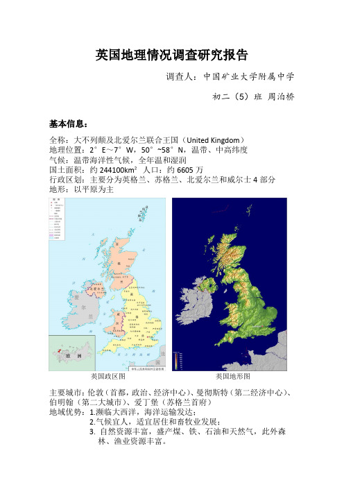
英国地理情况调查研究报告调查人:中国矿业大学附属中学初二(5)班周泊桥基本信息:全称:大不列颠及北爱尔兰联合王国(United Kingdom)地理位置:2°E~7°W,50°~58°N,温带、中高纬度气候:温带海洋性气候,全年温和湿润国土面积:约244100km²人口:约6605万行政区划:主要分为英格兰、苏格兰、北爱尔兰和威尔士4部分地形:以平原为主英国政区图英国地形图主要城市:伦敦(首都,政治、经济中心)、曼彻斯特(第二经济中心)、伯明翰(第二大城市)、爱丁堡(苏格兰首府)地域优势:1.濒临大西洋,海洋运输发达;2.气候宜人,适宜居住和畜牧业发展;3. 自然资源丰富,盛产煤、铁、石油和天然气,此外森林、渔业资源丰富。
地域劣势:1.农产品产量不足,依赖海运进口;2.长期与大陆隔绝,不利于经济、文化交流与发展。
调查实录:7月底去的英国,由于纬度较高,夏季昼长夜短,一般21:00才日落。
英国地处大西洋东岸,有着典型的温带海洋性气候。
今年西欧正逢百年一遇的高温天气,饶是如此,英国气温始终保持在32度以下。
小雨不断,但是并不会影响正常出行活动,是那种十分惬意的绵绵细雨。
伦敦是英国的政治、经济中心。
伦敦第一区(中心区)十分繁华:牛津街、摄政街、邦德街三大购物街,再加上旁边的考文特花园。
商品琳琅满目,应有尽有。
不过,由于近年来大量外来人口(特别是难民)涌入英国,伦敦治安不尽人意——常出现盗窃、抢劫、敲诈勒索等恶性案件。
不过总的来说,伦敦还是一个繁华的国际大都市。
伦敦与上海不同,在繁华地带并没有想象中这么多高楼大厦,而是保留了不少古建筑,并对其做了很好的内部改造,体现出浓浓的历史文化氛围。
此外,英国人注重自然环境,绿化率特别高。
英国强调人与自然和谐相处,宿舍楼下常有小松鼠出没。
英国虽然小虫较多,但少有苍蝇和花蚊子。
大街上蜜蜂飞来飞去,即使落在糕点上也不会带来疾病。
区域地理——英国

人文地理
文化
历史
英国历史可以划分为五大时 期。 一、史前时期(约公元40年 之前) (1) 石器时代 (2) 铜器时代 (3) 铁器时代 二、古典时期(约公元40年5世纪)
从国旗变化看英国的统一
人文地理
文化
语言
英国的语言资源非常丰富。英语(约6000万人使用,占总人口的98%) 是英国事实上的官方语言。除英语外,主要的土著语言还包括苏格兰语(约 150万人使用)、威尔士语(约70万人使用)、爱尔兰语、盖尔语和康沃尔 语等。此外,英国还有上百种外来语,根据2011年人口普查数据,使用最多 的十种外来语言为波兰语(约54万人使用)、旁遮普语(约27万人使用)、 乌尔都语(约27万人使用)、孟加拉语(约22万人使用)、古吉拉特语(约 21万人使用)、阿拉伯语(约16万人使用)、法语(约15万人使用)、汉语 (约14万人使用)、葡萄牙语(约13万人使用)、西班牙语(约12万人使 用)。(注:以上数据均为2011年人口普查数据)
英国有很多著名的风景胜地,这其中就包括数目众多的教堂 和大教堂。美国的教堂很少有历史超过一百年的,英国的教堂则 几乎没有历史在一百年以内的,甚至很多大教堂具有一千多年的 历史。
人文地理
名次 大学
地区
雅思
托福
文化
教育
1 牛津大学 2 剑桥大学 3 帝国理工学院
牛津郡 剑桥郡 大伦敦
[本]7.0[研]7.0 [本]110[研]100 [本]7.5[研]-- [本]--[研]-[本]6.5[研]6.5 [本]92[研]92
01 伦敦在国际贸易、金融方面有长期经营的历史,因而对许多外 国银行具有特殊的吸引力;
02 伦敦在长期经营金融中,拥有大量的金融机构,经验丰富的工 作人员和完整的通讯网络;
英国的气候特点属于什么气候

英国的气候特点属于什么气候英国的气候特点属于什么气候英国处于中高纬度地域,可是与同纬度其他地域相比英国的天气要温暖湿润的的多,下面是店铺给大家整理的英国的气候特点,希望能帮到大家!英国的气候特点英国位于北纬50度至60度之间,但气候温和,冬无严寒,夏无酷署,属温和湿润的海洋性气候。
英国全国一月份的平均气温约为4至7度,七月份13至17度。
年降雨量西北部山区超过1000毫米,而东南部在六七百毫米之间。
英国雾气较重,主要是岛国的潮气所致。
首都伦敦冬季河湖极少结冰,一月平均气温在4度(摄氏)以上;夏天则相当凉爽,七月的平均气温17度,早晚外出需加外衣。
年降雨量约600毫米,雨量分布较均匀。
至于伦敦过去常见的浓雾,并不完全是自然现象。
由于重视环境保护,伦敦目前出现浓雾的次数已大大减少。
英国虽然气候温和,但天气多变。
一日之内,时晴时雨。
多变的天气也为人们提供了经常的话题,在英国甚至最沉默寡言的人也喜欢谈论天气。
受高纬度的影响,英国昼夜长短的变化特别明显。
冬季日短夜长,夏季则日长夜短。
夏季是到英国旅游的最佳季节。
夏季日间长,活动时间多,而且温度适中,天气清爽,人的精神也倍感充沛。
这个季节尽管也有雨,但一般不会连绵不断,影响行程。
英国的地理环境气候特征英国属温带海洋性气候。
英国受盛行西风控制,全年温和湿润,四季寒暑变化不大。
植被是温带落叶阔叶林带。
通常最高气温不超过32℃,最低气温不低于-10℃,平均气温1月4~7℃,7月13~17℃。
年平均降水量约1000毫米。
北部和西部山区的年降水量超过2000毫米,中部和东部则少于800毫米。
每年二月至三月最为干燥,十月至来年一月最为湿润。
英国西北部多低山高原,东南部为平原泰晤士河是国内最大的河流。
英国终年受西风和海洋的影响,全年气候温和湿润,适合植物生长。
英国虽然气候温和,但天气多变。
一日之内,时晴时雨。
位置境域英国是位于西欧的一个岛国,是由大不列颠岛上英格兰、苏格兰、威尔士以及爱尔兰岛东北部的北爱尔兰共同组成的一个联邦制岛国。
英国的自然地理特征和人文特征简介

英国位于欧洲大陆西北部,是一个由英格兰、威尔士、苏格兰和北爱尔兰四个地区组成的联合王国。
以下是英国的自然地理特征和人文特征简介:
自然地理特征:
1. 英国是一个岛国,位于欧洲大陆和爱尔兰海之间,由大不列颠岛和爱尔兰岛组成。
2. 英国的气候温和湿润,受大西洋暖流的影响,冬季较温暖,夏季较凉爽,雨水分布均匀。
3. 英国地形多样,包括高山、丘陵、平原、河流和海岸线等。
苏格兰高地是英国最高的山脉,威尔士有许多山地和山谷,英格兰和北爱尔兰则以平原为主。
4. 英国的自然资源丰富,包括煤炭、石油、天然气、水力、林木等。
人文特征:
1. 英国是一个具有悠久历史和文化的国家,拥有许多著名的文化遗产和历史古迹,如巨石阵、巴斯泉、温莎城堡等。
2. 英国是英语的发源地和主要使用国家,英语是世界上使用最广泛的语言之一。
3. 英国是一个高度发达的经济体,拥有世界上最大的金融服务业和工业生产体系。
4. 英国的文化和艺术氛围浓厚,有许多著名的文学作品、音乐作品、电影和艺术品。
5. 英国的社会结构比较复杂,包括贵族、中产阶级和工人阶层等多个社会群体。
英国面积人口气候

英国面积人口气候1、英国,地理,地理位置,面积,人口,地形,气候等英国是大不列颠岛和爱尔兰岛东北部及附近许多岛屿组成的岛国。
东濒北海,面对比利时、荷兰、德国、丹麦和挪威等国;西邻爱尔兰,横隔大西洋与美国、加拿大遥遥相对;北过大西洋可达冰岛;南穿英吉利海峡行33公里就到法国。
英格兰全境面积为13万平方公里,占大不列颠岛的大部分。
这一地区自西向东分为4部分:以塞文河流域为中心的米德兰平原;海拔200米左右的高地;伦敦盆地;威尔德丘陵。
威尔士面积有2万余平方公里,境内多山、地势崎岖。
威尔士境内有1/4的土地被列为国家公园及天然保护区。
苏格兰和其周围的许多小岛,面积共为7.8万平方公里。
全境均属山岳地带,只有中部较为低平。
北爱尔兰面积1.4万平方公里,隔爱尔兰海与大不列颠岛遥遥相望。
北爱尔兰地区湖泊较多,英国的第一大湖——讷湖卧波其间。
沿湖为平原。
气候属海洋性温带阔叶制2、英国面积人口首都主要城市和历史欧洲大陆西部边缘及西部以外,有数千座岛,通常被叫做英吉利群岛。
群岛中最大的岛屿叫做大不列颠,为了简单起见,简称不列颠,不过官方正式名称仍为大不列颠。
它南北走向近 1000公里,东西绵延约500公里,面积大约为23万平方公里。
但是大不列颠及北爱尔兰联合王国的整体面积也只是稍多与24万平方公里,人口为5740万(1990)。
就大不列颠岛本身而言,被分为三部分,也被认为是三个国家:地处南部的英格兰,北部的苏格兰,和东南部的威尔士。
英格兰是三个政治实体中最大、最发达的一部分,土地面积超过13万平方公里,占了整个大不列颠岛近60%;人口超过4700万,约为正个国家的85%。
英格兰在大不列颠的地位如此重要以至于外国人称呼整个大不列颠为“英格兰”,这种习俗也用在了对人的称呼上,占多数的英格兰人被认为等同于“英国人”。
不列颠岛从北到南超过1000公里,它那1万公里长的海岸线,使得它成为拥有最长海岸线的国家之一。
在这个国家,没有任何地方离海的距离超过120公里。
英国自然环境特征

英国自然环境特征英国自然环境特征英国地处欧洲西北部,其自然环境特征因地处海洋性气候与温带大陆性气候交汇带中而呈现出多样性,包括丘陵、山区、海岸线和草原等特征。
这些地理特征影响着英国的气候、植被和野生动植物的分布,也为英国人民提供了丰富的自然资源和美丽的景观。
气候特征英国的气候特征主要由东风暖流和温带湿润气候所决定。
由于东风暖流的影响,英国的气候比大陆地区的气候更为温暖。
冬季温暖,夏季凉爽,气温波动小,降水较为均匀。
这种气候给予英国丰富的自然资源,使得英国的农业和渔业得以繁荣发展。
植被特征英国的植被主要呈现草原、森林和沼泽的特征。
草原分布广泛,主要分布在英格兰南部和威尔士,而森林主要分布在苏格兰和威尔士西部地区。
这些植被类型对于英国的生态环境和生物多样性起着至关重要的作用,特别是在保护英国的野生动植物和鸟类等方面。
地形特征英国的地形特征非常多样化,包括丘陵、山区、海岸线等。
其中英格兰东北地区和苏格兰高地是英国的两个主要山区。
最高峰是苏格兰的本内峰(Ben Nevis),海拔为1344米。
英国的海岸线也非常漫长,被认为是世界上最美的海岸之一,因其壮观的悬崖、金色的海滩和诸多的岛屿而闻名于世。
野生动植物特征英国的野生动植物丰富多样,包括狐狸、野兔、鹿、浣熊、松鼠、海豹等。
英国也是欧洲最多野鸟种类的国家之一,其中许多鸟类是在伦敦公园和英国自然保护区内观察到的。
英国的植物物种也非常多样,包括被誉为英伦三大花之一的矮牵牛、牛尾草和虎杖等。
总的来说,英国的自然环境特征是丰富多彩的,这些特征不仅影响着英国的气候、植被和野生动植物的分布,也使得英国成为一个拥有众多美丽景观和自然资源的国家。
然而,在经济和人口增长的推动下,英国的自然环境也面临许多挑战,需要我们共同呵护和保护这片美丽的土地。
七年级下册地理英国知识点

七年级下册地理英国知识点
英国是欧洲重要的岛国,位于欧洲大陆西北方向,由四个地区
组成:英格兰、威尔士、苏格兰和北爱尔兰。
本文将针对七年级
地理课程下册出现的英国相关知识点进行介绍。
一、地理位置与气候
英国位于北半球温带,气候温和多变。
最高峰为班恩山(Ben Nevis),高1344米。
英国南部地势平坦,北部有高地,著名的湖区在西北地区。
英国周围环绕着海洋,大西洋对西海岸冲击较为
剧烈,海岸线长达12000公里。
二、政治与经济
英国政治体系为君主立宪制,首都为伦敦,是英国的经济、文
化和旅游中心。
英国有发达的制造业、金融业、服务业和旅游业,汽车、电子、医药等行业发展迅速。
三、文化与教育
英国是世界文化名城,为文学、戏剧、电影、音乐等领域培养
了无数重量级人物。
英国的著名文化名胜包括大本钟、泰晤士河、伦敦塔桥、温莎城堡等。
英国拥有顶尖的教育体系和众多名校,
牛津大学和剑桥大学更是享有举世闻名的声誉。
四、民族文化与风俗习惯
英国人民对称呼自己的国家常用“大不列颠”、“不列颠群岛”和“联合王国”等三个名称。
英国人以茶饮为传统习俗,在下午3-4点时会喝茶、吃点心,这就是英国的“下午茶文化”;英国人通常开
着左驾驶的车,行车的方向规定为左侧行驶。
此外,英国人的音乐、文学等领域也形成了鲜明而深厚的民族文化。
总之,英国是一个有着丰富文化和历史的国家,拥有独特的地理、政治、经济等方面的特点。
对于学习地理的学生而言,了解
英国的相关知识点,不仅是对知识的积淀和丰富,更是对世界多
元文化的认知和理解。
关于英国的地理介绍

关于英国的地理介绍
英国是一个位于欧洲西北部的岛国,包括大不列颠岛、爱尔兰岛东北部的北爱尔兰和一百多个小岛。
它的地理位置、自然环境、人文历史使得英国成为了世界上一个非常特别的国家。
英国全称为“大不列颠及北爱尔兰联合王国”,国土面积约为24.41万平方公里,包括内陆水域),地理位置十分优越。
英国东濒北海,与比利时、荷兰、德国、丹麦和挪威隔海相望;西临爱尔兰共和国,隔大西洋与美国、加拿大遥望;北穿大西洋可到达冰岛;南渡英吉利海峡可抵达法国。
英国的气候属于温带海洋性气候,温暖湿润,气候宜人。
最热的天(7月)平均气温为13-21℃,最冷的天(1月)平均气温为4-7℃。
英格兰地势较低,年平均降水量830毫米,西部、北部山区雨量较大,最高可达4000毫米。
英国是一个多岩石高原、中低海拔区、平原和丘陵的组合。
英国的地貌包括大不列颠岛和爱尔兰岛东北部的北爱尔兰,其地理位置和自然环境为英国带来了丰富多彩的地貌景象,也为世人带来了很多独特的魅力和发掘的空间。
英国的人口密度不是很大,人口分散在不同的城市中,其中伦敦是全国最大的城市,也是英国的经济、文化、政治中心。
除了伦敦之外,英国其他的大城市也具有自身的特色和文化内涵。
总之,英国的地理位于欧洲西北角以及大不列颠岛和多岩石高原、中低海拔区、平原和丘陵的组合,形成了丰富多彩的地貌景象,带给了世人很多独特的魅力和发掘的空间。
英国的自然地理特征和人文特征简介

英国的自然地理特征和人文特征简介(实用版)目录一、英国的自然地理特征1.地理位置与气候2.地貌特征3.河流与湖泊二、英国的人文特征1.历史与文化2.政治与经济3.教育与科技正文一、英国的自然地理特征1.地理位置与气候英国位于欧洲西北部,地理坐标为北纬 50°~60°,西经 2°~7°。
其地理位置独特,东临北海,西濒大西洋,南界英吉利海峡,北靠北海。
英国气候属于海洋性气候,全年温和湿润,无极端气候,适宜人类居住。
2.地貌特征英国地貌多样,主要特征是大不列颠岛西北部为高地,东南部为平原,其间有起伏的丘陵。
英国的沿岸线曲折多变,有许多深深锲入内陆的海湾与河口。
岛上任何地方距离海洋都不超过 20 公里。
3.河流与湖泊英国的河流短小湍急,主要河流有塞文河、泰晤士河、康沃尔河等。
英国湖泊众多,主要分布在苏格兰地区,其中最著名的是尼斯湖。
二、英国的人文特征1.历史与文化英国历史悠久,公元前伊比利亚人、罗马人、盎格鲁 - 撒克逊人先后来到这片土地。
1066 年,诺曼底人在哈斯廷斯战役中击败了英格兰国王哈罗德,从此开始了诺曼人在英格兰的统治。
英国文化丰富多样,包括文学、音乐、戏剧、电影等。
著名作家如莎士比亚、狄更斯、简·奥斯汀等,音乐家如贝多芬、约翰·列侬等。
2.政治与经济英国实行君主立宪制,现任君主是伊丽莎白二世。
英国政治体系分为两大党派,保守党和工党。
经济方面,英国是资本主义国家,世界上第一个工业化国家,拥有世界著名的伦敦金融城。
3.教育与科技英国教育体系世界闻名,拥有世界顶级大学如剑桥大学、牛津大学等。
英国国家概况_

英国文化 英国是世界文化大国之一,文化产业发达。 全国约有2500家博物馆和展览馆对外开 放,其中大英博物馆、国家美术馆等闻名于 世。英国皇家芭蕾舞团、伦敦交响乐团等艺 术团体具有世界一流水准。每年举行约50 0多个专业艺术节,其中爱丁堡国际艺术节 是世界上最盛大的艺术节之一。当今世界8 0%的信息以英语传播。
英国国花:玫瑰花 .
英国,对于蔷薇、月季、玫瑰这三种花来说,人们总把它搞混, 它们虽同科同属,但却并不完全相同,但人们似乎比较偏爱玫瑰 这个词,所以把这三种花统称为玫瑰了。 在英国及欧美许多国家,都把玫瑰(月季)定为国花,以表示亲爱, 又因茎上有刺,表示严肃。基督教中,相传耶稣被出卖后,被钉 在十字架上,鲜血滴在泥土中,十字架下便生长出玫瑰花。 红玫瑰象征了爱情,这可能是世界通用的花语。相传爱神为了救 她的情人,跑得太匆忙,玫瑰的刺划破了她的手脚,鲜血染红了 玫瑰花。红玫瑰因此成了爱情的信物。 古波斯诗人在诗中曾说:神用玫瑰花加蛇、鸽子、蜂蜜、死海的 水、苹果、泥土混在一起,捏出了女人。 在这战争中,双方分别以红、白蔷薇作为标帜。英国人为了纪念 这个事迹,就以蔷薇作为国花了。蔷薇色泽艳丽,一年四季都会 开花。象徵高贵与恒久,所以,英国人又把它当作皇室的徽帜。 英国(England )的国花叫Tudor Rose是红白两种蔷薇合在一起 创造出来的人工花在自然界是没有的。
文化
英国是世界文化大国之一,文化产业发达。全国约 有2500家博物馆和展览馆对外开放,其中大英 博物馆、国家美术馆等闻名于世。英国皇家芭蕾舞 团、伦敦交响乐团等艺术团体具有世界一流水准。 每年举行约500多个专业艺术节,其中爱丁堡国 际艺术节是世界上最盛大的艺术节之一。当今世界 80%的信息以英语传播。 1840年5月6日,世界上第一枚邮票在英国诞 生。英国发行了世界上第一批邮票。这批邮票的发 明者是英国人罗兰· 希尔,邮票的票面是黑色的,上 面印着英国维多利亚女王的浮雕像,每枚面值1便 士,人们称它为“黑便士邮票”。后来人们把这一 天称为邮票诞生日。 联合国教科文组织命名英国格拉斯哥为“音乐 之城”
比较日本与英国的区域差异

比较日本与英国的区域差异——(仅限于10地科班)一:自然环境的差异1,地理位置:日本:位于亚欧大陆东岸,西、北隔东海、黄海、日本海、鄂霍次克海与中国、朝鲜、韩国、俄罗斯相望,东濒太平洋。
英国:位于亚欧大陆西北面,英国本土位于大不列颠群岛,被北海、英吉利海峡、凯尔特海、爱尔兰海和大西洋包围。
2,地形:日本:全国68%是山地,平原少,山上种植物,最大的平原为关东平原。
英国:主要地形为山地、平原和高原。
全境分为四部分:英格兰东南部平原、中西部山区、苏格兰山区、北爱尔兰高原和山区。
3,气候:日本:南部为亚热带季风气候,北部为温带季风气候。
因为日本为岛国,所以受到海洋的影响较大,因此日本的季风气候具有海洋性的特征,即降水量和气温变化较小,较为平均。
英国:属温带海洋性气候。
英国受盛行西风控制,全年温和湿润,四季寒暑变化不大。
年平均降水量约1000毫米。
4,水文:日本:河流多,但大多很短,流域面积不大;流量受季节影响变化较大,夏季有来自海洋的夏季风影响降水集中而且降水量多,河流流量最大,冬季很少。
英国:水体类型主要为河流和湖泊,由于英国属于温带海洋性气候,因此水源补给多来自盛行西风。
5,植被:日本:植被南部为亚热带常绿阔叶林,北部为温带落叶阔叶林。
英国:温带落叶阔叶林6,自然资源:日本:日本除鱼类, 森林和水力资源较丰富以外, 只有少量的矿物资源, 如石炭石、铅、铜矿、煤、硅石、铬铁矿、锌、金砂和锰等。
河流落差较大,因此水流很湍急,有较为丰富的水能资源。
日本北海道有世界最著名的渔场之一——北海道渔场,其成因是千岛寒流与日本暖流交汇。
英国:英国主要的矿产资源有煤、铁、石油和天然气。
硬煤总储量1,700亿吨。
铁的蕴藏量约为38亿吨。
西南部康沃尔半岛有锡矿。
在柴郡和达腊姆蕴藏着大量石盐。
斯塔福德郡有优质粘土。
康沃尔半岛出产白粘土。
奔宁山脉东坡可开采白云石。
兰开夏西南部施尔德利丘陵附近蕴藏着石英矿。
在英国北海大陆架石油蕴藏量约在10~40亿吨之间。
英国地理介绍ppt

英国地理介绍ppt英国位于欧洲大陆西北部,由英格兰、苏格兰、威尔士和北爱尔兰四个国家组成。
作为一个岛国,英国周围被海洋环绕,与法国隔海相望,地理位置独特。
下面我将向大家介绍英国的地理特点和主要地理景观。
第一部分:概述英国地理位置优越,东西长约1,000千米,南北宽约500千米。
总面积约244,820平方千米,其中陆地面积约241,930平方千米,水域面积约2,890平方千米。
英国是联合王国的缩写,不包括其他海外领地,如直布罗陀等。
第二部分:地形地貌英国地形复杂多样,包括高山、丘陵、平原和湖泊等。
英国最高峰是威尔士的雪顿山,海拔1,085米。
苏格兰高地是最著名的山地地区,有壮丽的峡谷和湖泊,如洛希尔湖和尼斯湖。
英格兰中部是一个广袤的平原,广袤的草甸和农田形成了英国田园风光的代表。
第三部分:河流湖泊英国的河流和湖泊众多,其中最重要的河流是泰晤士河,它贯穿伦敦,并成为英国最长的河流。
此外,塞文河、哈德良河等也是英国重要的河流。
关于湖泊,最有名的莫过于英格兰的湖区,湖光山色吸引了众多游客。
第四部分:海岸线英国拥有众多的海岸线,总长度超过17,380千米。
多样的地理条件使得沿海地区形成了各种不同类型的海岸景观,包括悬崖、沙滩和港口等。
多塞特郡和康沃尔郡的海岸线是著名的风景线,吸引了大量的游客。
第五部分:气候英国气候温和多变,受大西洋海洋性气候影响。
夏季相对凉爽,平均气温在15-25摄氏度之间,冬季相对温暖,平均气温在2-8摄氏度之间。
东部地区相对比较干燥,而西部地区则较为潮湿。
第六部分:自然保护区英国拥有许多自然保护区,这些区域保护了众多珍稀的物种和生态系统。
著名的自然保护区包括湖区国家公园、达特穆尔国家公园和泰恩河河口自然保护区等。
这些地方提供了丰富的生物多样性和迷人的风景。
总结:英国地理多样,拥有壮丽的山脉、美丽的湖泊和多样的海岸线。
丰富的自然资源和优越的地理位置使得英国成为独特而迷人的旅游目的地。
通过这个PPT,我们可以更加了解英国的地理特点,增加对这个国家的认识和理解。
英语国家地理与环境

英语国家地理与环境英语国家是指以英语为官方语言或广泛使用的国家,包括英国、美国、加拿大、澳大利亚、新西兰等国家。
这些国家的地理环境多种多样,从北极冰原到热带雨林,各有其独特之处。
本文将探讨英语国家的地理与环境特点。
英国是一个位于欧洲西南部的岛国,拥有着丰富的历史文化遗产。
英国的地理环境主要分为英格兰、苏格兰、威尔士和北爱尔兰四个地区。
英格兰是最大的地区,拥有伦敦这个国际大都市,而苏格兰则以苏格兰高地和湖区风景优美著称。
威尔士有着崎岖的山地和壮丽的海岸线,北爱尔兰则被称为“绿色岛屿”,拥有大片的草原和农田。
美国是一个拥有着广袤土地和多样气候的国家。
从东部的大西洋沿岸到西部的太平洋岸边,美国的地理环境各不相同。
东部沿海地区气候温和,而西部山脉则有着干旱的沙漠气候。
美国拥有众多的国家公园和自然保护区,如黄石国家公园、大峡谷国家公园等,吸引着来自世界各地的游客。
加拿大是一个位于北美洲北部的国家,拥有着丰富的自然资源和广阔的土地。
加拿大的地理环境既有大城市如多伦多、温哥华等,也有广袤的森林和冰川。
加拿大的洛矶山脉和落基山脉是滑雪爱好者的天堂,而北部的极地气候则适合观赏极光。
澳大利亚是一个位于南半球的大陆国家,拥有着丰富多样的自然景观。
从悉尼的海港到墨尔本的文艺氛围,澳大利亚的地理环境各具特色。
澳大利亚的大堡礁是世界上最大的珊瑚礁系统,吸引着众多潜水爱好者。
而澳大利亚的红土地则是阿伦达沙漠和大维多利亚沙漠的典型代表。
新西兰是一个位于南太平洋的岛国,被誉为“上帝的自画像”。
新西兰的地理环境包括有着壮观山脉和湖泊的南岛,以及有着绿色牧场和火山的北岛。
新西兰的地质活动频繁,火山和地热资源丰富。
新西兰还拥有着世界上最古老的原始森林,如被誉为“霍比特人之乡”的南岛蒂亚诺湖等。
总的来说,英语国家的地理环境多种多样,从寒冷的极地到炎热的沙漠,各有其独特之处。
这些国家不仅拥有着丰富的自然资源和人文景观,也承载着深厚的历史文化底蕴。
英国简介概况

英国简介概况大不列颠及北爱尔兰联合王国,通称英国,是由大不列颠岛上的英格兰、苏格兰和威尔士,以及爱尔兰岛东北部的北爱尔兰以及一系列附属岛屿共同组成的一个西欧岛国.位于欧洲的西北部。
英国根据其地理轮廓可以被分成高地和低地。
高地主要位于英国的北部和西部,低地主要位于英国的南部和东部。
英国的人口分布不均衡,主要集中在四个地方:英格兰的人口占总人口大约84%,威尔士大约占5%,苏格兰占8.5%,而北爱尔兰仅占不足3%。
下面分别对英国的四个组成部分进行分别的介绍。
首先是英格兰:英格兰是英国最大的组成部分,拥有最多的人口,并且是主要的低地地带。
英格兰拥有伟大的作家包括:莎士比亚、狄更斯、和简奥斯丁等等。
英格兰的主要运动项目是足球,主要的使用语言是英文。
苏格兰:苏格兰位于英国的北部,主要被分成三个部分:第一部分是西北部和高地以及西部和东北部的一些岛。
第二部分是低地的中心地带,许多商业中心和大多数耕地可以在这里被找到。
苏格兰主要的人口分布在行政中心和爱丁堡的首都、、、、等等。
苏格兰拥有繁荣的旅游产业,英语是苏格兰人的母语。
威尔士:威尔士位于英国的西部,是个高地部落。
威尔士在西欧有着最有名的城堡,也有很强的音乐和文化传统。
英语是威尔士的主要语言,但是威尔士语在许多学校被教,而且有大约20%的人说威尔士语。
北爱尔兰:北爱尔兰坐落于爱尔兰岛英语是北爱尔兰人的母语。
英国主要河流有塞文河(354公里)和泰晤士河(346公里)。
北爱尔兰的讷湖(396平方公里)面积居全国之首。
属海洋性温带阔叶林气候,终年温和湿润。
通常最高气温不超过32℃,最低气温不低于-10℃,平均气温1月4~7℃,7月13~17℃。
多雨雾,秋冬尤甚。
年平均降水量约1000毫米。
北部和西部山区的年降水量超过1600毫米,中部和东部则少于800毫米。
每年三月至六月最为干燥,九月至来年一月最为湿润。
整个英国没有极端天气出现,整个国家基本上冬暖夏凉。
其中,一月和二月是英国最冷的时期。
英国的地理现象

2.2河流和湖泊
泰晤士河:英国最长 的河流,流经伦敦, 是英国的母亲河
01
默西河:流经英格兰 西北部,是利物浦和 曼彻斯特的主要水源
03
02
塞文河:英国第二大 河,流经英格兰中部 和南部
04
湖泊:英国有许多湖泊, 如温德米尔湖、科茨沃 尔德湖等,是旅游胜地 和休闲场所
泰晤士河
美丽的泰晤士河是英国的母亲河。 它自发源地英格兰西部的科茨沃尔 德山,汩汩而下,穿过青山绿林和 葱笼草地,流入伦敦市区,逶迤而 去,最后经诺尔岛注入北海。比起 地球上的一些大江大河,它不算长, 但它流经之处,都是英国文化精华 所在,或许可以反过来说,泰晤士
英国的地理现象
老师:_______________
目录
1 英国的地理位置 2 英国的地形地貌 3 英国的气候特征
01
英国的地理位置
1.1 是欧洲西部岛国
英国位于欧 洲西部,大 西洋东北部
隔英吉利海 峡与法国相 望
01
03
02
04
由大不列颠岛、 爱尔兰岛东北 部及一系列小 岛组成
海岸线曲折, 多优良港湾, 有利于航海 和贸易
3.3极端天气和自然灾害
1
暴风雪:冬季 常见,可能导 致交通中断和 电力供应中断
3
干旱:夏季少 雨,可能导致 农作物减产和
森林火灾
2
洪水:夏季多 雨,可能导致 河流泛滥和城
市内涝
4
地震:英国位 于地震活跃地 区,可能发生
地震灾害
大暴雨的多重冲击下,塞文河引起洪涝:
谢谢
主要分布在欧洲 西部、北美洲西 部和南美洲南部
原因:受海 洋影响,气 温变化较小
3.2 季节变化和降水
春节去英国的天气情况

春节去英国的天气情况春节期间,英国的天气情况可以说是多变的。
由于英国位于北欧洲靠近大西洋的海洋性气候区域,整体上表现为温和湿润的气候。
但是每年的冬季一般都会有一段时间的低温和降雪现象。
以下是对春节在英国的天气情况的详细描述。
英国的天气情况主要受到大西洋气团的影响,这意味着它往往比较湿润和多风。
春节期间,英国的气温通常在摄氏0至摄氏10度之间,但随着地理位置的不同,气温可能有所不同。
南部和西部地区的气温相对较暖,而苏格兰地区则更冷一些。
通常情况下,春节期间的英国天气可能非常阴雨连绵,这是因为大西洋上的低气压系统和冷空气团相互作用所引起的。
英国的雨季通常从秋季持续到春季,春节期间也不例外。
这意味着您很可能会遇到阴沉的天气和阵雨,需要准备一把雨伞和雨衣。
春节期间还有可能会出现降雪的情况,特别是在苏格兰和北部地区。
虽然英国的降雪量一般较少,但是如果有降雪的话,可能会对交通、道路和航班产生一定的影响。
此时您需要注意天气预报并做好相应的准备。
另外,春节期间的英国也有可能会迎来寒冷的天气。
尽管平均温度较低,但大部分城市还不会下降到很低的水平。
不过,如果您计划在戶外活动或参观景点,您仍然需要穿着足够保暖的衣物,包括毛衣、外套、围巾和帽子。
需要注意的是,在英国,气候变化非常迅速。
一天之内可能会有多个气候转变,从阳光明媚到阴云密布,甚至是短暂的暴雨。
因此,建议您随身携带一件外套或防水外层,以便随时适应天气变化。
总的来说,春节期间的英国天气情况可能是多变的。
您可能会遇到阴雨天气、降雪和较低的气温。
为了应对这种情况,建议您关注当地的天气预报并做好相应的准备,包括准备雨具、保暖衣物和防水外套。
这样您就可以更好地享受您在英国的春节假期。
- 1、下载文档前请自行甄别文档内容的完整性,平台不提供额外的编辑、内容补充、找答案等附加服务。
- 2、"仅部分预览"的文档,不可在线预览部分如存在完整性等问题,可反馈申请退款(可完整预览的文档不适用该条件!)。
- 3、如文档侵犯您的权益,请联系客服反馈,我们会尽快为您处理(人工客服工作时间:9:00-18:30)。
英国地理气候
全称、不列颠群岛、面积由大到小的组成
气候温和降雨量充足最高最低气温
最大部分英格兰伦敦
面积、河流、意义
首都(英格兰、英国)、国际影响、伦敦西部
Good morning everyone, today we are going to talk about British geography.Before our presentation, let’s distinguish several geographical names first. It’s fundamental.The full name of Britain is the United Kingdom of Great Britain and Northern Ireland. Located to the northwest of mainland Europe, it is made up of many islands collectively known as the British Isles, including two main islands, Great British and Ireland. Together, Britain is made up of four parts: England, Scotland, Wales and Northern Ireland.
From the map, we can also find it that the UK is surrounded by oceans, so it has a temperate maritime climate, withtemperature here rarely rising above 32 in summer or falling below -10 in winter.plentiful precipitation throughout the year
The largest part of Great Britain is England, with an area of 130,281 square kilometers and cover more than half of the whole island. It is also the most populous and wealthiest part of the country, so people sometimes refer to the whole country as England, a name that people from other parts of the country dislike.
The capital of England is London, and it is also known as the capital of the U.K, which is the center of the country from various angles. The RiverThames, the second longest and most important river in Britain locates here.The West End of London includes many tourist attractions, as well as business and administrative headquarters. There are some examples on the slides.。
