worldview-3 的绝对辐射定标系数
利用WorldView-3立体影像生产1∶2000比例尺3D产品

利用WorldView-3立体影像生产1∶2000比例尺3D产品肖潇;左琛;侯庆明;李兵【摘要】立体卫星影像在覆盖范围、重访周期、测绘产品更新速度、数据获取成本等方面较传统航空影像有着较明显的优势.WorldView-3是迄今全球空间分辨率最高的商业遥感卫星,全色波段分辨率0.31m,能获取同轨立体像对,理论上可代替传统航空影像用于大比例尺测图.本文以北京市石景山区和通州区的两个WorldView-3立体像对为数据源,确定了一整套制作1∶2000比例尺3D产品的技术流程,具体包括数字线划图(Digital Line Graphic,DLG)、数字高程模型(Digital Elevation Model,DEM)和正射影像图(Digital Orthophoto Map,DOM),验证了3D产品的精度,成图结果符合国标精度要求,并为生产作业中控制点布设方案、密集匹配算法选取等提供了参照和解决方案.【期刊名称】《北京测绘》【年(卷),期】2019(033)003【总页数】4页(P310-313)【关键词】立体像对;数字线划图(DLG);数字高程模型(DEM);数字正射影像图(DOM)【作者】肖潇;左琛;侯庆明;李兵【作者单位】北京市测绘设计研究院,北京100038;城市空间信息工程北京市重点实验室,北京100038;北京市测绘设计研究院,北京100038;城市空间信息工程北京市重点实验室,北京100038;北京市测绘设计研究院,北京100038;城市空间信息工程北京市重点实验室,北京100038;北京市测绘设计研究院,北京100038;城市空间信息工程北京市重点实验室,北京100038【正文语种】中文【中图分类】P2310 引言目前,基于摄影测量技术制作1∶2000比例尺3D产品,包括数字线划图 (Digital Line Graphic, DLG)、数字高程模型 (Digital Elevation Model, DEM)和数字正射影像图 (Digital Orthophoto Map, DOM),多是以航空像片为原始数据,航片分辨率高,能满足大比例尺基础地理信息数据产品生产的精度要求。
基于WorldView-3卫星遥感影像立体测图方案研究

第41卷第11期2018年11月测绘与空间地理信息GEOMATICS&SPATIALINFORMATIONTECHNOLOGYVol.41ꎬNo.11Nov.ꎬ2018收稿日期:2018-03-19作者简介:王玉训(1966-)ꎬ男ꎬ山东青岛人ꎬ工程师ꎬ本科学历ꎬ主要从事大地测量㊁工程测量㊁航空摄影测量与遥感等方面的应用研究工作ꎮ基于WorldView-3卫星遥感影像立体测图方案研究王玉训(辽宁省基础测绘院ꎬ辽宁锦州121000)摘要:以WorldView-3卫星遥感影像为例ꎬ探讨利用WorldView-3卫星遥感影像相关的亚米级卫星遥感影像进行大比例尺立体测图的各种生产工艺流程ꎬ以实际生产中的某测区为例ꎬ收集该测区的本底影像资料ꎬ并获取相关的外业资料ꎬ对生产数据进行区域网平差和数据检校ꎬ分析各种方案的优缺点ꎬ对测区精度进行分析ꎬ得出利用WorldView-3卫星遥感影像进行立体测图DLG生产的生产方案ꎮ关键词:WorldView-3ꎻ卫星遥感影像ꎻ立体测图ꎻDLG生产中图分类号:P237㊀㊀㊀文献标识码:A㊀㊀㊀文章编号:1672-5867(2018)11-0110-02ResearchonStereoMappingSchemeBasedonWorldView-3SatelliteRemoteSensingImageWANGYuxun(BasicSurveyingandMappingInstituteofLiaoningProvinceꎬJinzhou121000ꎬChina)Abstract:UsingWorldView-3satelliteremotesensingimageasanexample.ToexploretheuseofWorldView-3satelliteremotesens ̄ingimagerelatedsubmetersatelliteremotesensingimageinlargescalestereomappingofthevariousproductionprocesses.Withatestintheactualproductionasanexampleꎬthecollectionareasofthebackgroundimagedataandaccesstorelevantinformationoutsidetheindustry.Regionaladjustmentandcalibrationdataofproductiondata.Analyzingtheadvantagesanddisadvantagesofvariousschemes.Thetestareaaccuracyisanalyzed.TheproductionplanofstereomappingwithDLGproductionobtainedbyWorldView-3satellitere ̄motesensingimage.Keywords:WorldView-3ꎻsatelliteremotesensingimageꎻstereomappingꎻDLGproduction0㊀引㊀言常用的国际商业高分辨率光学遥感卫星有美国的IKONOS㊁QuickBird㊁GeoEye-1㊁WorldView-2㊁WorldView-3ꎬ韩国的Kompsat㊁法国的Pleiades㊁SPOT6㊁SPOT7等[1]ꎮ本文以WorldView-3卫星遥感影像为例ꎬ研究探讨基于0.31m分辨率的WorldView-3影像立体测图关键技术研究及生产方案研究ꎮ1㊀WorldView-3卫星遥感影像简介WorldView-3卫星是美国DG公司于2014年8月发射的第四代高分辨率光学卫星ꎬ卫星影像全色分辨率为0.31mꎬ拥有16个多光谱波段ꎬ多光谱分辨率为1.24mꎬ短波红外分辨率为7.5mꎬ支持同轨立体成像采集ꎬ平面精度3.5mꎬ高程精度2m[2]ꎮWorldView-3卫星成像分幅为13.1kmˑ14kmꎬ采集能力为约每天68万km2ꎮ与World ̄View-2卫星相比ꎬWorldView-3卫星全色分辨率从0.5m提高到0.31mꎬ大大提升了航天快速测图和应急响应能力[3]ꎮ2㊀立体测图工艺流程卫星影像立体测图不同于传统航空摄影立体测图ꎬ其工艺流程与传统测图既有区别又有相似之处ꎬ工艺流程分为外业控制点量测㊁区域网平差㊁立体测图㊁外业精度检测㊁外业调绘㊁内业成图等步骤ꎬ如图1所示ꎮ图1㊀卫星影像立体测图工艺流程Fig.1㊀Workflowofstereosatelliteimagemapping利用卫星影像进行立体测图内业4D产品生产流程包括导入影像㊁导入控制点㊁空三加密㊁区域网平差ꎬ最终生成4D产品ꎬ如图2所示ꎮ图2㊀卫星影像4D产品生产流程Fig.2㊀Productionworkflowofsatelliteimage4Dproducts地物在卫星影像上的肉眼分辨率取决于传感器CCD的分辨率㊁卫星运行的轨道高度㊁光谱的波段㊁地物的大小㊁地物反射率与周围地物反射率的差异程度㊁地物的遮挡情况等ꎮ3㊀测区试验情况试验区选取国内某大城市ꎬ按照该城市1ʒ2000库数据的分层进行测图ꎬ各层说明如下ꎮ02层(居民地和垣栅)ꎮ有85% 90%的房屋可以看清并准确地定位(平房区角点模糊)ꎬ其定位的平面精度可以达到0.87mꎮ03层(工矿建(构)筑物及其他设施)ꎮ独立地物部分看不清ꎬ能够看清楚可以准确定位的约为50%ꎬ以电线杆为例ꎬ能够看清并可以准确定位的精度x方向为0.45mꎬy方向为0.55mꎬ平面精度为0.71mꎮ04层(交通及附属设施)ꎮ道路除了遮挡(如阴影㊁树木等)情况外ꎬ90%左右都能看清楚ꎮ在x方向的精度可以达到0.49mꎬy方向的精度可以达到0.52mꎬ其平面精度为0.76mꎮ05层(管线及附属设施)ꎮ测区内某大型钢铁公司的管线可以识别ꎬ电力线基本看不清ꎬ无法准确定位ꎬ可识别管线平面精度达到0.94mꎮ06层(水系及附属设施)㊁08层(地貌和土质㊁高程注记)㊁09层(植被)均与测区航空摄影数据相同ꎮ4㊀精度情况及试验结论为了检测内业数据采集的精度ꎬ需要进行外业监测点的量测ꎬ与外业控制点的量测类似ꎬ需要均匀分布于整个测图区域ꎬ而且每张图的外业检测点个数在100个以上ꎮ当量测建筑物时如有房檐则量测房檐投影到地面点的坐标ꎬ而不是量测房基坐标ꎮ基于WorldView-3卫星立体像对的内业采集精度完全满足1ʒ2000地形图的精度ꎮ然而ꎬ对于高分辨率卫星来说ꎬ虽然可以达到0.31m的空间分辨率ꎬ在测绘1ʒ2000地形图测绘时ꎬ影像上还有20% 30%的地物不能辨别ꎬ导致定位失败ꎬ需要外业人员进行野外测量ꎮ在丘陵地区ꎬ369个房角点ꎬ平面精度中误差0.610mꎬ见表1ꎬ误差分布见表2ꎮ表1㊀平面精度表Tab.1㊀Planeprecisiontable误差项误差值minX0X0.388maxX1.714minY0.001Y0.471maxY2.243minXY0.005XY0.610maxXY2.524表2㊀平面误差分布Tab.2㊀Planeerrordistribution条件个数百分比总点数369100%小于1倍中误差27273.7%小于2倍中误差7620.6%小于3倍中误差164.3%大于3倍中误差51.4%173个高程点ꎬ高程精度中误差0.129mꎬ误差分布见表3ꎮ表3㊀高程误差分布Tab.3㊀Elevationerrordistribution条件个数百分比总点数173100%小于1倍中误差12371.1%小于2倍中误差4023.12%小于3倍中误差84.62%大于3倍中误差21.16%(下转第120页)111第11期王玉训:基于WorldView-3卫星遥感影像立体测图方案研究根据待检目标特性ꎬ调节视觉特征对显著图生成的影响ꎬ有利于得到更好的检测结果ꎮ针对面状目标ꎬ我们设计算法最初考虑采用基于聚类的图像分割方法从显著图中检测目标ꎬ但实验表明这样会影响算法效率ꎬ故采用自适应阈值分割方法并进行形态学滤波处理的方式更为合适ꎮ参考文献:[1]㊀保铮.雷达成像技术[M].北京:电子工业出版社ꎬ2005. [2]㊀S.Yantis.Toseeistoattend[J].Scienceꎬ2003ꎬ29(5603):54-56.[3]㊀N.KanwisherꎬE.Wojciulik.Visualattention:insightsfrombrainimaging[J].NatureNeuroscienceꎬ2000ꎬl(2):91-100.[4]㊀J.M.WolfeꎬT.S.Horowitz.Whatattributesguidethede ̄ploymentofvisualattentionandhowdotheydoit[J].Na ̄tureNeuroscienceꎬ2004(5):1-5.[5]㊀苑丽红ꎬ付丽ꎬ杨勇ꎬ等.基于灰度共生矩阵提取纹理特征的实验结果分析[J].计算机应用ꎬ2009ꎬ29(4):1018-1021.[编辑:任亚茹](上接第111页)㊀㊀根据国家1ʒ2000地形图测绘标准和规范ꎬ本次试验精度满足1ʒ2000地形图的测图精度ꎮ5㊀结束语本文针对WorldView-3卫星影像进行了立体测图试验ꎬ探讨了基于高分辨率卫星影像的立体测图方案ꎬ分析和论述了未来卫星遥感影像的立体测图前景ꎬ通过1ʒ2000地形图测绘试验推导出基于高分辨率卫星影像的4D产品生产的可行性ꎮ参考文献:[1]㊀李国元ꎬ胡芬ꎬ张重阳ꎬ等.WorldView-3卫星成像模式介绍及数据质量初步评价[J].测绘通报ꎬ2015(S1):11-16.[2]㊀韦蔚ꎬ高永红ꎬ张戈兰.基于WorldView数据的西藏桑德地区快速制图方法[J].地理空间信息ꎬ2017ꎬ15(12):25-27.[3]㊀祝晓坤.基于WorldView-3卫星多视角数据的三维实景建模技术研究[J].城市勘测ꎬ2017(5):6-11. [4]㊀王睿ꎬ葛韬ꎬ李淳.基于天绘卫星影像的困难地区地形图测制方法[J].测绘与空间地理信息ꎬ2017ꎬ40(11):165-166ꎬ170.[5]㊀王睿ꎬ魏伟ꎬ许宁.利用WorldView-2影像测制困难地区地形图的技术探讨[J].测绘与空间地理信息ꎬ2017ꎬ40(12):144-145ꎬ149.[6]㊀祝晓坤ꎬ左琛ꎬ刘晓琳ꎬ等.米级/亚米级卫星遥感影像大比例尺立体测图试验研究[J].测绘与空间地理信息ꎬ2016ꎬ39(3):28-31.[7]㊀王亚男ꎬ马燕燕ꎬ万保峰ꎬ等.无人机航摄1ʒ2000立体测图关键技术探讨[J].地矿测绘ꎬ2016ꎬ32(1):30-33. [8]㊀刘学杰.像控布设方案对无人机航测精度影响的测试[J].地理信息世界ꎬ2016ꎬ23(5):109-112.[编辑:任亚茹](上接第115页)3㊀结束语现如今ꎬ中国城市化建设与新农村建设日益加快ꎬ城市发展与土地利用的矛盾也日益加剧ꎬ如何在发展的同时解决土地的矛盾ꎬ成为现在各城市必须解决的一个问题ꎮ本文以南城县为例ꎬ依据地理国情普查地表覆盖数据中的房屋建筑区数据ꎬ并基于计算景观格局指数的方法来表征各乡镇之间的差异ꎬ选用主成分分析方法ꎬ得到斑块面积㊁周长面积比㊁景观蔓延度指数㊁景观丰富度密度指数来表达研究区各乡镇特征ꎬ而后利用聚类分析方法将研究区各乡镇分成5类ꎬ最后提出了 南镇㊁北农㊁东水㊁西景 和 一心四片 的空间格局发展理念ꎮ依据该理念ꎬ可以有效地整合规范南城县居民点用地ꎬ优化城镇空间布局ꎬ加快推进新型城镇化步伐ꎬ科学指导生态文明城市建设ꎮ由于景观格局分析是有尺度效应的ꎬ本文未考虑该因素ꎬ故引入尺度效应是今后的重点研究方向ꎮ参考文献:[1]㊀邬建国.景观生态学 格局㊁过程㊁尺度与等级[M].北京:高等教育出版社ꎬ2000.[2]㊀齐伟ꎬ曲衍波ꎬ刘洪义ꎬ等.区域代表性景观格局指数筛选与土地利用分区[J].中国土地科学ꎬ2009ꎬ23(1):33-37.[3]㊀黄思琴ꎬ陈英ꎬ张仁陟ꎬ等.基于景观格局指数的农村居民点土地利用分区研究[J].中国农学通报.2014ꎬ30(23):98-103.[4]㊀鲍艳ꎬ胡振琪ꎬ柏玉ꎬ等.主成分聚类分析在土地利用生态安全评价中的应用[J].农业工程学报ꎬ2006ꎬ22(8):87-90.[5]㊀章文波ꎬ陈红艳.使用数据统计分析及应用 SPSS12.0[M].北京:人民邮电出版社ꎬ2006.[6]㊀陶军德ꎬ关国锋ꎬ汤永玲.哈尔滨市阿城区农村居民点景观格局与空间分布特征分析[J].国土与自然资源研究ꎬ2011ꎬ27(5):27-29.[7]㊀谭雪兰ꎬ段建南ꎬ包春红ꎬ等.基于GIS的麻阳县农村居民点空间布局优化研究[J].水土保持研究ꎬ2010ꎬ17(6):177-180.[编辑:任亚茹]021㊀㊀㊀㊀㊀㊀㊀㊀㊀㊀㊀㊀㊀㊀测绘与空间地理信息㊀㊀㊀㊀㊀㊀㊀㊀㊀㊀㊀㊀㊀㊀㊀㊀2018年。
Worldview3(WV3)卫星成像模式及卫星参数介绍
北京揽宇方圆信息技术有限公司Worldview3(WV3)卫星成像模式及卫星参数介绍2014年8月13号,Digitalglobe公司的Worldview3(WV3)卫星已经成功发射并正式运行,WV3卫星提供31厘米全色分辨率\1.24米多光谱分辨率和3.7米红外短波分辨率。
WorldView-3除了提供0.31米分辨率的全色影像和8波段多光谱影像外,还提供8波段短波红外影像。
这颗卫星提供的极高空间分辨率,可以分别更小、更细的地物,可以跟航空影像相媲美。
拥有的覆盖可见光、近红外、短波红外的波谱特征,使WorldView-3拥有极强的定量分析能力,在植被监测、矿产探测、海岸/海洋监测等方面拥有广阔的应用前景。
WorldView-3目前正由Ball Aerospace公司建造,该公司设计并制造了DigitalGlobe目前运行的所有卫星。
卫星载荷包括短波红外传感器和光学仪器在内的成像仪器则由ITT Exelis公司设计和制造。
值得一提的是,ENVI/IDL遥感图像处理软件的制造商Exelis VIS公司是ITT Exelis公司的全资子公司。
Exelis VIS公司为WorldView1/2研发了支持软件,主要是研制基于流程的影像质量控制(QC)软件平台和为NextView计划提供新的影像质量检测工具。
DigitalGlobe现有的卫星群由QuickBird、WorldView-1和WorldView-2组成,WorldView-3将在此基础上进一步扩展这一行业领先的商业成像卫星群的各项功能。
该卫星群对地球表面的任何地点均可实现平均每天两次的访问,因而能够准确捕获包括大部分彩色图像在内的全球75%以上的半米分辨率商业图像。
WorldView-3的平均回访时间不到1天,每天能够采集多达680,000平方公里范围的数据,相对其他亚米级商业卫星有着更广的光谱范围,使其特征提取/变化监测/植物分析等领域有着卓越的表现。
Worldview1、Worldview2、Worldview3、Worldview4影像波段
Worldview1、Worldview2、Worldview3、Worldview4影像
1、Worldview-1卫星
国科创(北京)信息技术有限公司-WorldView-1卫星提供0.5米超高分辨率的全色影像。
2、Worldview-2卫星
Worldview-2包含9个光谱带。
蓝色,绿色,黄色,红色,红色边缘和NIR 波段、沿海气溶胶。
全色波段的地面分辨率为0.450米,多光谱的地面分辨率为1.85米。
波段范围
3、Worldview-3卫星
Worldview-3的光谱带有全色,蓝色,绿色,黄色,红色,红色边缘,近红外和、短波红外、沿海气溶胶。
Worldview-3的所有波段的地面采样距离均得到了改善。
全色为31厘米,VNIR波段为1.2米,而SWIR波段的GSD为3.7米。
波段范围
4、Worldview-4卫星
Worldview-4具有全色,蓝色,绿色,红色和近红外波段。
它的地面采样距离与Worldview-3相同,全色波段为0.31米,所有其他波段为1.2米。
波段范围
国科创(北京)信息技术有限公司遥感事业部提供多尺度、多分辨率、全覆盖的遥感影像数据产品服务,拥有多光谱、高光谱、雷达卫星、无人机影像等遥感数据,可提供环保、国土、农业、水利和林业等应用领域的人工智能目标识别、图像分类、正射纠正、图像处理、解译、咨询服务,以及基于多源影像的综合应用解决方案。
国科创(北京)信息技术有限公司是中关村高新技术企业,也是国家高新技术企业,拥有ISO9001、ISO14001、OHSAS18001资质,也通过了信息安全管理体系和信息技术服务管理体系双认证,可提供专业的遥感数据产品服务。
Worldview3(WV3)卫星样例数据下载@北京揽宇方圆
尺寸:5.7 米(18.7 英尺)高 x 2.5 米(8 英尺)宽 » 航天器尺寸、 太阳能电池帆板展开后总跨度 7.1 米(23 英尺) 重量、功率 质量:2800 公斤(6200 磅) 功耗:太阳能电池 3.1 千瓦,蓄电池 100 安培小时
传感器波段
全色: 450 - 800 纳米 8 个多光谱: 海岸带: 400 - 450 纳米 红: 630 - 690 纳米 蓝: 450 - 510 纳米 红边: 705 - 745 纳米 绿: 510 - 580 纳米 Near-IR1: 770 - 895 纳米 黄: 585 - 625 纳米 Near-IR2: 860 - 1040 纳米 8 个 SWIR 波段: SWIR-1: 1195 - 1225 纳米 SWIR-5: 2145 2185 纳米
WorldView-3 的平均回访时间不到 1 天,每天能够采集多达 680,000 平方公里范围 的数据,相对其他亚米级商业卫星有着更广的光谱范围,使其特征提取/变化监测/植物分 析等领域有着卓越的表现。
特点
优势
超高分辨率*
同步高分辨率超光谱影像
--全色 31 厘米
大面积单景和立体采集可消除时态
--多光谱 1.24 米
的敏捷性
星载存储器 2199 Gb 固态存储,含 EDAC
通信
图像与辅助数据:800 和 1200 Mbps X 波段 星务:4、16、32 或 64 kbps 实时,524 kbps 存 储,X 波段 指令数据:2 或 64 kbps S 波段
单景:66.5 公里 x 112 公里(5 条) 单程最大 立体:26.6 公里 x 112 公里(2 对)
北京揽宇方圆信息技术有限公司
Worldview3(WV3)卫星样例数据下载@北京揽宇方圆
worldview1卫星worldview2卫星worldview3卫星参数及官网价格
WorldView-2卫星
WorldView-2卫星于2009年10月6日发射,提供0.5米全色图像和1.8米分辨率的多光谱图像。
该卫星将使Digitalglobe公司能够为世界各地的商业用户提供满足其需要的高性能图像产品。
星载多光谱遥感器不仅将具有4个业内标准谱段(红、绿、蓝、近红外),还将包括四个额外(海岸、黄、红边和近红外2)。
多样性的谱段将为用户提供进行精确变化检测和制图的能力,由于WorldView卫星对指令的响应速度更快,因此图像的周转时间(从下达成像指令到接收到图像所需的时间)仅为几个小时而不是几天.
WorldView-2卫星能提供独有的8波段高清晰商业卫星影像。
除了四个常见的波段外(蓝色波段:450-510;绿色波段:510-580;红色波段:630-690;近红外线波段:770-895),
新的彩色波段分析
(1)海岸波段(400-450)这个波段支持植物鉴定和分析,也支持基于叶绿素和渗水的规格参数表的深海探测研究。
由于该波段经常受到大气散射的影响,已经应用于大气层纠正技术。
(2)黄色波段(585—625)过去经常被说成是yellow-ness特征指标,是重要的植物应用波段。
该波段将被作为辅助纠正真色度的波段,以符合人类视觉的欣赏习惯。
(3)红色边缘波段(705-745)辅助分析有关植物生长情况,可以直接反映出植物健康状况有关信息。
(4)近红外2 波段(860-1040)这个波段部分重叠在NIR 1波段上,但较少受到大气层的影响。
该波段支持植物分析和单位面积内生物数量的研究。
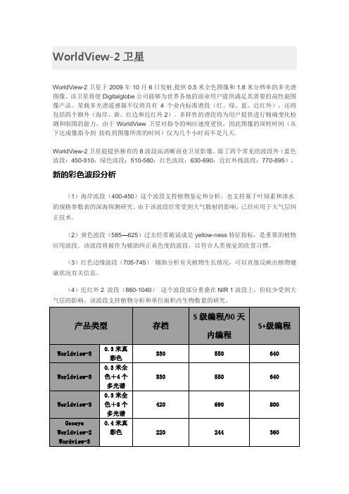
北京揽宇方圆遥感卫星数据方案选择
北京揽宇方圆卫星数据方案选择一、光学卫星介绍1.分辨率优于0.5米的光学卫星(1)WorldView-3卫星WorldView-3卫星是美国GigitalGlobe公司于2014年8月发射并开始运行的一颗遥感卫星,它是第一颗多负载、超高光谱、高分率的商业卫星,最高可提供0.31米全色分辨率、1.24米多光谱分辨率,此外WorldView-3大大提高了卫星的光谱分辨率,在WorldView-2的八波段多光谱的基础上加入了3.7m分辨率的短波红外波段,并且首次在高分辨率卫星中使用了CAVIS波段用于大气校正。
WorldView-3卫星平均回访时间不到1天,每天可采集多达68万平方公里的数据。
以下是WorldView-3卫星的部分技术参数。
WorldView-2在2009年发射,该卫星的运行轨道高度770km。
能够提供0.5米的分辨率的全色和1.8米分辨率的多光谱影像。
星载多光谱传感器不仅具有4个标准波段(红、绿、蓝和近红外1),还将包括4个新的波段(海岸监测、黄、红波段的边缘和近红外2)。
增加的波段信息,为用户提供进行精确变化检测和制图的能力。
B.WorldView-2卫星拍摄能力分析WorldView-2卫星是全球第一批使用了控制力矩陀螺(CMGs)的商业卫星。
这项高性能技术可以提供多达10倍以上的加速度的姿态控制操作,从而可以更精确的瞄准和扫描目标。
卫星的旋转速度可从60秒减少至9秒,覆盖面积达300公里。
所以,WorldView-2卫星能够更快速、更准确的从一个目标转向另一个目标,同时也能进行多个目标地点的拍摄。
卫星具有更灵活的运转、更高容量更快回访、更精确的拍摄、多波段高清晰影像四个特点:●更灵活的运转WorldView-2卫星能非常灵活运转,它在太空中的角色就像一个神奇的画笔,能灵活的前后扫描、拍摄大面积的区域,能在单次操作中完成多频谱影像的扫描。
WorldView-2卫星独有的大容量系统,能达到每日采集一百万平方公里的数据采集量。
WorldView-3卫星影像全部信息介绍

北京揽宇方圆信息技术有限公司WorldView-3卫星影像全部信息介绍WorldView-3WorldView-3为美国DigitalGlobe公司拥有的第四代高分辨率光学卫星,于2014年8月成功发射,它拍摄的影像分辨率最高可达31公分,为目前市面上分辨率最高的商业光学卫星。
WorldView-3不但具有与WorldView-2同样的高光学分辨率与高几何精度,而且能在更短的时间内获取影像数据,拍摄面积更为广泛。
除去WorldView-2提供的8波段光谱信息外,还新增了额外的20个特殊波段,包括8个短波长红外光波段(SWIR,short-wave infrared),更有利于特殊地物的分类与侦测。
此外,亦提供了12个分布于可见光至不可见光的CAVIS-ACI波段,有利于云雾侦测、影像修复及求得更正确的地物反射率,得到更加美观的影像。
WorldView-3卫星基本参数发射日期2014年8月13日卫星寿命7年以上轨道形式太阳同步卫星轨道高度617公里飞行周期97分钟(绕地球一圈)航带拍摄宽度13.1公里(nadir)单轨连续拍摄面积单幅:66.5×112公里立体像对:26.6×112公里重访频率1天(优于1公尺分辨率<,span>)4.5天(优于0.34公尺分辨率)空间分辨率全色态:0.31公尺(Nadir),0.34公尺(20°off-nadir)多光谱:1.24公尺(Nadir),1.38公尺(20°off-nadir)几何精度(CE90) 3.5公尺(无需控制点状态)辐射分辨率全色态&多光谱:11-bits/pixelSWIR:14-bits/pixel北京揽宇方圆信息技术有限公司是国内的领先遥感卫星数据机构,而且是整合全球的遥感卫星数据资源,分发不同性能、技术应用上可以互补的多种卫星影像,包括光学、雷达卫星影像、历史遥感影像等各种卫星数据服务,各种专业应用目的的图像处理、解译、顾问服务以及基于卫星影像的各种解决方案等。
高分辨率遥感卫星影像有哪些世界高分辨率卫星排名

高分辨率遥感卫星影像有哪些世界高分辨率卫星排名北京揽宇方圆信息技术有限公司是美国DigitalGlobe公司、法国SPOT公司在中国的合作伙伴,代理销售其全球数据。
资源三号高分二号高分一号北京揽宇方圆优惠提供。
一、卫星类型(1)光学卫星:worldview1、worldview2、worldview3、quickbird、geoeye、ikonos、pleiades、spot1、spot2、spot3、spot4、spot5、spot6、landsat5(tm)、landsat(etm)、rapideye、alos、资源三号、高分一号、高分二号。
(2)雷达卫星:terrasar-x、radarsat-2(3)侦查卫星:美国锁眼卫星全系例(1960-1980)二、卫星分辨率(1)0.3米:worldview3(2)0.4米:worldview3、worldview2、geoeye(3)0.5米:worldview3、worldview2、geoeye、worldview1、pleiades(4)0.6米:quickbird、锁眼卫星(5)1米:ikonos、高分二号。
(6)1.5米:spot6、锁眼卫星(7)2.5米:spot5、alos、资源三号、高分一号、锁眼卫星(8)5米:spot5、rapideye、锁眼卫星(9)10米:spot5、spot4、spot3、spot2、spot1(10)15米:landsat5(tm)、landsat(etm)三、卫星国籍(1)美国:worldview1、worldview2、worldview3、quickbird、geoeye、ikonos、landsat5(tm)、landsat(etm)、锁眼卫星(2)法国:pleiades、spot1、spot2、spot3、spot4、spot5、spot6(3)中国:资源三号、高分一号、锁眼卫星、高分二号。
(4)德国:terrasar-x、rapideye(5)加拿大:radarsat-2四、卫星发射年代(1)1960-1980年:锁眼卫星(0.6米分辨率至10米)(2)1980-1990年:landsat5(tm)、spot1(3)1990-2000年:spot2、spot3、spot4、landsat(etm)、ikonos(4)2000-2010年:quickbird、worldview1、worldview2、spot5、rapideye、radarsat-2(5)2010-:spot6、资源三号、高分一号、worldview3、pleiades、高分二号。
WorldView-3卫星简介
WorldView-3卫星简介国科创(北京)信息技术有限公司-WorldView-3是美国DigitalGlobe公司第四代高分辨率光学卫星,于2014年8月中发射,卫星影像分辨率为0.3米,是目前世界上分辨率最高的光学卫星。
WorldView-3除了提供0.31米分辨率的全色影像和8波段多光谱影像外,还提供8波段短波红外影像(目前提供的短波红外产品分辨率是7.5米)和12个CAVIS波段影像。
这颗卫星是目前世界上最高的分辨率,可以分别更小、更细的地物。
WorldView-3具有的覆盖可见光、近红外、短波红外的波谱特征,使WorldView-3拥有极强的定量分析能力,在植被监测、矿产探测、海岸/海洋监测等方面拥有广阔的应用前景。
短波红外(SWIR)影像非常适合对人造和天然材料进行分类,穿透烟雾,探测火情,绘制矿物图等。
WorldView-3卫星拥有的高分辨率短波红外图像提供的空间信息内容是ASTER卫星和Landsat 8卫星提供的SWIR数据的16倍。
更高的分辨率意味着更准确地在地球表面上找到人造材料(金属,塑料,油漆,玻璃纤维,沥青,石油和各种化学物质)和地质矿物(粘土,蚀变,氧化铁,碳酸盐等)并进行分类。
通过突出土壤水分含量的SWIR波段组合识别水体、检测湿度。
通过SWIR波段能够穿透烟雾的能力清晰地观察地面,在大火中识别燃烧点,监视火山喷发,并通过使用SWIR图像检测高热排放来识别由工厂机械或其他人为活动产生的热量等等。
WorldView-3卫星光谱分布WorldView3卫星优点:•同步高分辨率超光谱影像。
•大面积单景和立体采集可消除时态变化。
•无地面控制点亦可实现精确地理定位。
•每天采集全球68万平方公里的影像。
•卓越的阴霾穿透能力。
•行业领先的地理定位精度(十分稳定的平台,高精度姿态传感器和GPS)。
•在多种拍摄类型下均提供了高容量(比竞争对手的产品宽)。
•使用控制力矩陀螺迅速重新瞄准目标(比其他任何竞争对手快2 倍以上)。
北京揽宇方圆WorldView-3卫星影像定标参数

Radiometric Use of WorldView-3 ImageryTechnical NoteDate: 2016-02-22Prepared by: Michele KuesterThis technical note discusses the radiometric use of WorldView-3 imagery. The first two sections briefly describe the WorldView-3 instrument and general radiometric performance including the WorldView-3 relative spectral radiance response and relative radiometric correction of WorldView-3 products. Section 3 covers conversion to top-of-atmosphere spectral radiance and conversion to top-of-atmosphere spectral reflectance. WorldView-3 imagery MUST be converted to spectral radiance at a minimum before radiometric/spectral analysis or comparison with imagery from other sensors in a radiometric/ spectral manner. The information contained in this technical note applies to the raw WorldView-3 sensor performance and linearly scaled top-of-atmosphere spectral radiance products. Caution is advised when applying the equations provided here to pan-sharpened products, dynamic range adjusted (DRA) products, or WorldView-3 mosaics with radiometric balancing because the generation of these products may apply non-linear transformations to the pixel DN values.1 WorldView-3 InstrumentThe WorldView-3 high-resolution commercial imaging satellite was launched on August 13, 2014, from Vandenberg Air Force Base. The satellite is in a nearly circular, sun-synchronous orbit with a period of 97 minutes, an altitude of approximately 617 km, and with a descending nodal crossing time of approximately 10:30 a.m. The revisit is 4.5 days at a greater than 20-deg off nadir angle. WorldView-3 acquires 11-bit data in 9 spectral bands covering panchromatic, coastal, blue, green, yellow, red, red edge, NIR1, and NIR2. An additional shortwave infrared (SWIR) sensor acquires 14-bit data in eight bands covering the 1100 to 2500 nm spectral region. See Table 1 for details. At nadir, the collected nominal ground sample distance is 0.31 m (panchromatic), 1.24 m (multispectral) and 3.7 m (SWIR). Commercially available products are resampled to 0.3 m (panchromatic), 1.2 m (multispectral) and 7.5 m (SWIR). The nominal swath width is 13.1 km (slightly less for the SWIR sensor). The WorldView-3 instrument is a pushbroom imager, which constructs an image one row at a time as the focused image of the Earth through the telescope moves across the linear detector arrays, which are located on the focal plane.1.1 WorldView-3 Relative Radiance ResponseThe spectral radiance response is defined as the ratio of the number of photo-electrons measured by the instrument system, to the spectral radiance [W-m-2-sr-1-µm-1] at a particular wavelength present at the entrance to the telescope aperture. It includes not only raw detector quantum efficiency, but also transmission losses due to the telescope optics and filters. The spectral radiance response for each band is normalized by dividing by the maximum response value for that band to arrive at a relative spectral radiance response. The curves for theWorldView-3 visible and near infrared multispectral bands are shown in Figure1. The curves for the WorldView-3 SWIR bands are shown in Figure2. The corresponding data are provided in AttachementA.Figure 1: WorldView-3 Relative Spectral Radiance Response (nm) for the VNIR bands.Figure 2: WorldView-3 Relative Spectral Radiance Response (nm) for the SWIR bands.1.2 WorldView-3 Effective BandwidthThe effective bandwidth for each band of the WorldView-3 system is defined as:where Δλ is the effective bandwidth in µm for a given band, and Rʹ(λ) is the relative spectral radiance response for a given band. The effective bandwidths should be used in the conversion to top-of-atmosphere spectral radiance for each band and are listed in Table 1. For reference, the center wavelength for each band is also given. The effective bandwidths are also included in the image metadata (.IMD file extension) accompanying the image product.Table 1. WorldView-3 Effective Bandwidths2 Relative Radiometric Correction of WorldView-3 ProductsRelative radiometric calibration and correction are necessary because a uniform scene does not create a uniform image in terms of raw digital numbers (DNs). Major causes of non-uniformity include variability in detector response, variability in electronic gain and offset, lens falloff, and particulate contamination on the focal plane. These causes manifest themselves in the form of streaks and banding in imagery. In the case of a pushbroom system focal plane containing linear arrays, the data from every pixel in a given image column comes from the same detector. Any differences in gain or offset for a single detector show up as a vertical streak in raw imagery. Differences in gain and offset for a single readout register show up as vertical bands as wide as the number of detectors read out by the register. Relative radiometric correction minimizes these image artifacts in WorldView-3 products.A relative radiometric correction is performed on raw data from all detectors in all bands during the early stages of WorldView-3 product generation. This correction includes a dark offset subtraction and a non-uniformity correction (e.g. detector-to-detector relative gain).Spectral BandCenter Wavelength(nm)Effective Bandwidth, Δλ (µm)Panchromatic 649.40.2896Coastal 427.40.0405Blue 481.90.0540Green 547.10.0618Yellow 604.30.0381Red 660.10.0585Red Edge 722.70.0387NIR1824.00.1004NIR2913.60.0889SWIR11209.10.0330SWIR21571.60.0397SWIR31661.10.0373SWIR41729.50.0416SWIR52163.70.0389SWIR62202.20.0409SWIR72259.30.0476SWIR82329.20.0679It is important to note that, after radiometric correction, the corrected detector data are spatially resampled to create a specific WorldView-3 product that has relative radiometrically corrected image pixels. Once spatial resampling is performed, the radiometric corrections are not reversible. Data from all WorldView-3 detectors are relative radiometrically corrected and used to generate WorldView-3 products. To date, no detectors have been declared as non-responsive detectors. The WorldView-3 VNIR instrument collects data with 11 bits of dynamic range. These 11 bits are either stored as 16 bit integers or are scaled down to 8 bits to reduce the file sizes of WorldView-3 products and for use with specific COTS tools that can only handle 8-bit data. The same is done for the 14 bit SWIR data. Whether the final bit depth is 16 or 8 bits, the goal of the relative radiometric correction, other than minimize image artifacts, is to scale all image pixels to top-of-atmosphere spectral radiance so that one absolute calibration factor can be applied to all pixels in a given band.3 Absolute Radiometric Correction of WorldView-3 Products and Conversion to T op-of-Atmosphere Spectral RadianceWorldView-3 products are delivered to the customer as relative radiometrically corrected image pixels. Their values are a function of how much spectral radiance enters the telescope aperture and the instrument conversion of that radiation into a digital signal. That signal depends on the spectral transmission of the telescope and filters, the throughput of the telescope, the spectral quantum efficiency of the detectors, and the analog to digital conversion. Therefore, image pixel data are unique to WorldView-3 and should not be directly compared to imagery from other sensors in a radiometric/spectral sense. In addition, bands taken at different TDI levels may give misleading spectral information if left in digital number space. Image pixels should be converted to top-of-atmosphere spectral radiance at a minimum.A pre-flight calibration has been performed and these data are provided in the .IMD metadata file that is delivered with the imagery. Since launch, DigitalGlobe has performed an extensive vicarious calibration campaign to provide an adjustment to the pre-launch values. The top-of-atmosphere radiance, L, in units of Wµm-1 m-2 sr-1, is then found from the DigitalGlobe image product for each band by converting from digital numbers (DN) using the equation,The TDI and scan direction specific abscalfactor and effectiveBandwidth are delivered with the imagery in the metadata file. The digital number, DN, is the pixel value found in the imagery. The Gain and Offset are the absolute radiometric calibration band dependent adjustment factors that are given in Table 2. Note that these are not necessarily static values and they are revisited annually.Table 2. Absolute radiometric Calibration Adjustment Factors for WorldView-3 as of 1/29/2016. It is recommended that these values are used for more accurate at sensor radiance values. Updates will be made available to the public online alongside this technical paper or by request.CAL VERSION2015v2BAND GAIN OFFSETPAN0.923-1.700The absolute radiometric calibration factor and effective bandwidth values for each band are delivered with every WorldView-3 product and are located in the image metadata files (extension .IMD). An excerpt from a product .IMD file shows the absolute radiometric calibration factor (absCalFactor) and the effective bandwidth (effectiveBandwidth), for example:BEGIN_GROUP = BAND_C …absCalFactor = 9.295654e-03;effectiveBandwidth = 4.730000e-02;END_GROUP = BAND_CThis example is for the coastal band. There are sections for each band, in particular: BAND_C = Coastal; BAND_B = Blue; BAND_G = Green; BAND_Y = Yellow; BAND_R = Red; BAND_RE = Red Edge; BAND_N = NIR1; BAND_N2= NIR2. Note that the values are provided in scientific notation.The absolute radiometric calibration factor is dependent on the specific band, as well as the TDI exposure level, line rate, pixel aggregration, and bit depth of the product. Based on these parameters, the appropriate value is provided in the .IMD file. For this reason, care should be taken not to mix absolute radiometric calibration factors between products that might have different collection conditions.COASTAL 0.863-7.154BLUE 0.905-4.189GREEN 0.907-3.287YELLOW 0.938-1.816RED 0.945-1.350REDEDGE 0.980-2.617NIR10.982-3.752NIR20.954-1.507SWIR1 1.160-4.479SWIR2 1.184-2.248SWIR3 1.173-1.806SWIR4 1.187-1.507SWIR5 1.286-0.622SWIR6 1.336-0.605SWIR7 1.340-0.423SWIR81.392-0.3024 Conversion to T op-of-Atmosphere ReflectanceFor many multispectral analysis techniques such as band ratios, Normalized Difference Vegetation Index (NDVI), matrix transformations, etc., it is common practice to convert multispectral data into reflectance before performing the analysis. In addition, techniques for removal of atmospheric effects range from a simple dark object subtraction or empirical line method, to more robust radiative transfer approaches. These methods require that first the imagery be normalized for solar irradiance and sensor radiance by conversion to top of atmosphere reflectance, ρ(TOA)λ.where L λ is the at-sensor radiance for the spectral band λ in W/m 2/µm/sr found in the previous section above, d is the Earth-Sun distance in astronomical units, E λ is the band-averaged solar exoatmopsheric irradiance in W/m 2/µm, and is the solar zenith angle.Top-of-atmosphere reflectance does not account for topographic, atmospheric, or BRDF differences. Consult the references by Schott or Schowengerdt for further discussion on correction for topographic or atmospheric effects. Typically a dark object subtraction technique is recommended at a minimum to reduce atmospheric effects due to the upwelling path radiance (Richards, p. 46, 1999 or Schowengerdt, p. 315, 1997) followed by atmospheric modeling.4.1 Solar Exoatmospheric IrradianceThe WorldView-3 instrument is sensitive to wavelengths of light in the visible through shortwave-infrared portions of the electromagnetic spectrum as shown in Figure 1 and Figure 2. In this region, top-of-atmosphere radiance measured by WorldView-3 is dominated by reflected solar radiation. Spectral irradiance is defined as the energy per unit area falling on a surface as a function of wavelength. Because the Sun acts like a blackbody radiator, the solar spectral irradiance can be approximated using a Planck blackbody curve at 5900 degrees Kelvin, corrected for the solar disk area and the distance between the Earth and the Sun (Schowengerdt, pp. 36-37, 1997). However, a model of the solar spectral irradiance is better used for this purpose. The solar spectral irradiance curve peaks around 450 nm in the coastal and blue bands and slowly decreases at longer wavelengths. The WRC Solar Spectral Irradiance Curve is shown in Figure 3 as an example. Thuillier 2003 is used for the vicarious calibration work at DigitalGlobe and is our recommended curve. The ChKur and WRC band averaged values are also given as they are also widely used and accepted in the remote sensing community. NOTE: the curves are given for an Earth-Sun distance of 1 Astronomical Unit (AU) normal to the surface being illuminated.In general, band-averaged solar spectral irradiance is defined as the weighted average of the peak normalized effective irradiance value over the detector bandpass as shown in the following equation:where Esun λBand is the band-averaged solar spectral irradiance [W-m -2-µm -1] for a given band, Esun(λ) is the solar spectral irradiance curve [W-m -2-µm -1] (WRC shown in Figure 3), and R ʹ(λ)Band is the relative spectral radiance response for a given band.∫∫∞∞⋅ʹ⋅ʹ⋅=BandBandBand d )(R d )(R )Esun(Esun λλλλλλFigure 3: WRC Solar Spectral Irradiance CurveSpecific to WorldView-3, the band-averaged solar spectral irradiance values for an Earth-Sun distance of 1 AU, normal to the surface being illuminated, are listed in Table 3.Table 3: WorldView-3 Band-Averaged Solar Spectral IrradianceSpectral Irradiance [W-m-2-µm-1]SpectralBandThuillier2003 ChKur WRCPAN1574.411578.281583.58COASTAL1757.891743.91743.81BLUE2004.611974.531971.48GREEN1830.181858.11856.26YELLOW1712.071748.871749.44.1.2 Earth-Sun DistanceIn order to calculate the Earth-Sun distance for a given product, the customer must first use the image acquisition time to calculate the Julian Day. The acquisition time for a product is contained in the image metadata file (.IMD file extension). Acquisition time uses the UTC time format and in the relevant section of the .IMD files looks like: Basic Product:BEGIN_GROUP = IMAGE_1 … firstLineTime = YYYY_MM_DDThh:mm:ss:ddddddZ; …END_GROUP = IMAGE_1Standard (projected) Product:BEGIN_GROUP = MAP_PROJECTED_PRODUCT …earliestAcqTime = YYYY_MM_DDThh:mm:ss:ddddddZ; …END_GROUP = MAP_PROJECTED_PRODUCTFrom the UTC time format, retrieve the year, month, day and calculate the Universal Time (UT) from the hours, minutes, and seconds:RED 1535.331550.581555.11REDEDGE 1348.081303.41343.95NIR11055.941063.921071.98NIR2858.77858.632863.296SWIR 1479.019478.873494.595SWIR 2263.797257.55261.494SWIR 3225.283221.448230.518SWIR 4197.552191.583196.766SWIR 590.417886.565180.365SWIR 685.064282.003574.7211SWIR 776.950774.741169.043SWIR 868.098866.390659.8224If the customer has an algorithm that can calculate the Julian Day, that value can also be used. Otherwise use the equationslisted below (Meeus, p. 61, 1998). The word “int” listed in the equations means to truncate the decimals and only use the integer part of the number. If the image was acquired in January or February, the year and month must be modified as follows:Next, calculate the Julian Day (JD):As an example, the WorldView-2 launch date of October 8, 2009 at 18:51:00 GMT corresponds to the Julian Day 2455113.285. Once the Julian Day has been calculated, the Earth-Sun distance (d ES ) can be determined using the following equations (U.S. Naval Observatory):NOTE: g is in degrees but most software programs require radians for cosine calculations. Conversion may be necessary for g from degrees to radians. The Earth-Sun distance will be in Astronomical Units (AU) and should have a value between 0.983 and 1.017. For the WorldView-2 launch date, the Earth-Sun distance is 0.998987 AU. At least six decimal places should be carried in the Earth-Sun distance for use in radiometric balancing or top-of-atmosphere reflectance calculations.3600.0ss.dddddd60.0mm hh UT DDday MM month YYYYyear ++====12month month 1year year +=−=[][]1524.5B 24.0UTday )1month (30.6001int )4716year (365.25int JD 4A int A 2B 100year int A −++++⋅++⋅=⎟⎠⎞⎜⎝⎛+−=⎟⎠⎞⎜⎝⎛=)cos(2g 0.00014cos(g)0.016711.00014d D0.98560028357.529g 2451545.0JD D ES ⋅−⋅−=⋅+=−=4.1.2 Solar Zenith AngleThe solar zenith angle does not need to be calculated for every pixel in an image because the sun angle change is very small over the 13.4 km image swath and the along-track image acquisition time. The average solar zenith angle for the image is sufficient for every pixel in the image. The average sun elevation angle [degrees] for a given product is calculated for the center of the scene and can be found in the .IMD files:BEGIN_GROUP = IMAGE_1 … meanSunEl = 68.7; … END_GROUP = IMAGE_1The solar zenith angle is simply:This example is for a sun elevation angle of 68.7 degrees, which corresponds to a solar zenith angle of 21.3 degrees. 5 Radiometric Balancing for Multiple Scene MosaicsFor many customers, it may be desirable to create large area mosaics from multiple WorldView-3 scenes. Ignoring geometric effects, adjacent areas might appear to have different brightness values leaving a visible seam between scenes. As stated earlier, WorldView-3 pixel digital numbers are a function of the spectral radiance entering the telescope aperture at the WorldView-3 altitude of 617 km. This top-of-atmosphere spectral radiance varies with Earth-Sun distance, solar zenith angle, topography (the solar zenith angle is calculated for flat terrain so topography adds an extra geometry factor for each spot on the ground), bi-directional reflectance distribution function (BRDF-the target reflectance varies depending on the illumination and observation geometry), and atmospheric effects (absorption and scattering).Topography, BRDF, and atmospheric effects can be ignored for simple radiometric balancing. Consequently, the major difference between two scenes of the same area is the solar geometry. The solar spectral irradiance values listed in Table 4 correspond to the values for the mean Earth-Sun distance, normal to the surface being illuminated. The actual solar spectral irradiance for a given image varies depending on the Earth-Sun distance and the solar zenith angle during the individual image acquisition. This variation will cause two scenes of the same area (or adjacent areas) taken on different days to have different radiances and hence different image brightnesses. The difference can be minimized by correcting imagery for Earth-Sun distance and solar zenith angle or simply converting to top-of-atmosphere solar reflectance as described in this technical document.6 SummaryRaw WorldView-3 imagery undergoes a relative radiometric correction process to reduce visible banding and streaking in WorldView-3 products. The products are linearly scaled to absolute spectral radiance. Various types of spectral analysis can be performed on this radiometrically corrected WorldView-3 imagery. Depending on the application, WorldView-3 products may need to be converted to top-of-atmosphere spectral radiance or spectral reflectance. These transformations are performed using the equations listed in this technical note. In the case of large area mosaics, Top-of-atmosphere reflectance is recommended as a starting point. Additional radiometric balancing may help match the brightness of the scenes used in thesunEl S −=0.90θmosaic. For customers interested in comparing WorldView-3 products with imagery from other sensors, keep in mind the spectral response curves and gain settings which are specific to WorldView-3. Many of the differences in analysis results can be explained by the differences in the sensors themselves.7 ReferencesMeuss, Jean. "Astronomical algorithms, 2nd Ed.." Richmond, VA: Willmann-Bell(1998).Richards, John A. and Xiuping Jia. “Remote Sensing Digital Image Analysis: An Introduction 3rd ed.,” Springer, Berlin, 1999. Schott, John R. “Remote Sensing: The Image Chain Approach,” Oxford University Press, New York(1997). Schowengerdt, Robert A. “Remote Sensing: Models and Methods for Image Processing 2nd ed.,” Academic Press, San Diego(1997).Thuillier, G., et al. "The solar spectral irradiance from 200 to 2400 nm as measured by the SOLSPEC spectrometer from the ATLAS and EURECA missions." Solar Physics 214.1 (2003): 1-22.Wehrli, C. “Extraterrestrial Solar Spectrum,” Publication 615, Physikalisch-Metrologisches Observatorium Davos and World Radiation Center, Davos-Dorf, Switzerland, pp. 23(1985).。
Worldview3卫星影像参数
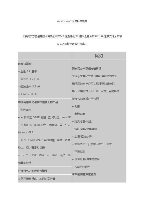
Worldview3卫星影像参数
北京揽宇方圆信息技术有限公司WV3卫星提供31厘米全色分辨率\1.24米多光谱分辨率
和3.7米红外短波分辨率。
优势
超高分辨率*
--全色31 厘米--多光谱1.24 米--短波红外3.7 米-- CAVIS 30 米同步高分辨率超光谱影像
大面积单景和立体采集可消除时态变化无地面控制点亦可实现精确地理定位
每天采集全球680,000 平方公里的影像新增和加强版应用包括:
--制图
--土地分类
--防灾准备/响应
--特征提取/变化监测
--土壤/植物分析
--地质情况:石油和天然气、采矿
--环境监测
--水深测量/海岸带应用
--人造材料识别
卓越的阴霾穿透能力
市场有售中光谱多样性最大的产品
--全色波段
-- 4 种标准VNIR 颜色:蓝、绿、红、near-IR1 -- 4 种附加VNIR 颜色:海岸带、黄、红边和near-IR2
-- 8 个SWIR 波段:穿透阴霾、尘雾、烟雾、粉尘、烟、薄雾和卷云
-- 12 个CAVIS 波段:云、浮质、蒸汽、冰和雪的校准
行业领先的地理定位精度
在各种采集模式中均拥有高容量。
资源三号卫星绝对辐射定标系数

资源三号卫星绝对辐射定标系数
我国首颗民用高分立体测绘卫星资源三号已在轨运行近一年,中国资源卫星应用中心于2012年8月开展了敦煌辐射校正场定标试验,成功获取了资源三号卫星多光谱相机在轨绝对辐射定标系数。
现将初步结果予以公布,希望广大用户积极使用,开展定量化应用示范研究。
同时,欢迎提出宝贵意见和建议,共同推动国产卫星遥感数据的定量化应用工作。
1、资源三号卫星多光谱相机绝对辐射定标系数见表1
表1 资源三号卫星在轨绝对辐射定标系数
2、利用绝对辐射定标系数将多光谱图像DN值转换为辐亮度图像的公式为:
⋅
=
L Gain DN
式中L为转换后辐亮度,单位为W⋅m-2⋅sr-1⋅μm-1,Gain为定标增益,DN为卫星载荷观测值。
认识WorldView卫星影像数据
认识WorldView卫星影像数据北京揽宇方圆信息技术有限公司认识WorldView卫星影像数据-每个文件夹的含义卫星简介WorldView-2于2009年10月6日发射升空,运行在770Km高的太阳同步轨道上。
更高的轨道带来了更短的重访周期和更好的拍摄机动性。
作为Digital Globe公司当时先进的遥感卫星,它同样使用了控制力矩陀螺技术。
这项高性能技术可以提供多达10倍以上的加速度的姿态控制操作,从而可以更精确的瞄准和扫描目标。
卫星的旋转速度可从QuickBird的60秒减少至9秒,星下摆动距离达200km。
所以,WorldView-2在太空中的角色就像一个神奇的画笔,能灵活的前后扫描、拍摄大面积的区域,能在单次操作中完成多频谱影像的扫描。
除了更快速的采集和更高的精度,WorldView-2还是第一颗具有八波段多光谱的高分辨率遥感卫星,它不但具有传统遥感卫星的四个多光谱波段,还新增加了海岸线、黄、红边和近红外2波段。
影像参数1.主文件夹MUL文件夹里是多光谱影像,分辨率较低,可用前期处理分析;PAN文件夹里是全色影像,立体成图主要使用该数据;GIS_FILES文件夹里面存储了shp格式的影像范围、订购范围、分块范围等,坐标与影像坐标一致,该数据对布设像控点很有帮助;LAYOUT文件是本次采集影像区域示意图。
从上图可以看出,奎卢河流域获取了两个区域立体影像,分别是P001和P002。
2.影像文件夹一般情况下,我们订购的影像都是分块存储的,上图就是一幅分块影像的所有文件。
(1)*.ATT——姿态文件:存储第一个数据点的时间、数据点数目、点和姿态信息间隔。
(2)*.EPH——星历文件:存储第一个数据点获取的时间、数据点数目、点和星历信息之间的间隔。
(3)*.GEO——几何定标文件:虚拟相机的标注摄影测量参数,是基础产品的相机和光学系统之间的关系。
(4)*.IMD——影像元数据文件:存储影像关键信息,包括产品级别、角点坐标、投影信息、获取时间、分辨率、视线高度、方位角、云覆盖率等。
worldview3影像参数

DigitalGlobe 公司近期公布了其 WorldView-3 卫星的最新进展,预计 2014 年发射。
WorldView-3 除了提供 0.31 米分辨率的全色影 像和 8 波段多光谱影像外,还提供 8 波段短波红外影像。
这颗卫星提供的极高空间分辨率,可以分别更小、更细的地物,可以跟航空影 像相媲美。
拥有的覆盖可见光、近红外、短波红外的波谱特征,使 WorldView-3 拥有极强的定量分析能力,在植被监测、矿产探测、海 岸/海洋监测等方面拥有广阔的应用前景。
WorldView-3 目前正由 Ball Aerospace 公司建造,该公司设计并制造了 DigitalGlobe 目前运行的所有卫星。
卫星载荷包括短波红外 传感器和光学仪器在内的成像仪器则由 ITT Exelis 公司设计和制造WorldView-3 為美國 DigitalGlobe 公司擁有之第四代高解析度光學衛星,已於 2014 年 8 月中發射,其拍攝之影像解析度最高可達 31 公分,為目前市面上解析度最高的商業光學衛星。
除承襲 WorldView-2 的高光學解析度與高幾何精度之外,並因能於更短的時間內獲取影像資料,也讓拍攝 面積更為廣泛。
其拍攝影像延續 WorldView-2 提供之 8 波段光譜資訊外,並新增了額外的 20 個特殊波段,包括 8 個短波長紅外光波段(SWIR, short-wave infrared),更有利於特殊地物的分類與偵測。
此外,亦提供了 12 個分布於可見光至不可見光的 CAVIS-ACI 波段,有利於雲霧偵測、影 像修復及求得更正確的地物反射率,得到更加美觀的影像。
新增優勢 Enhancements: 新增 8 個 SWIR 波段 提供 12 個分布於可見波段及短熱紅外波段中的大氣校正波段 影像下載速率提升 50% 解析度提高 20%,相同的像幅內增加 20%的像素 太空載具系統效能的提升 WorldView-3 提供更廣泛的影像光譜分布新增的特殊波段更拓展了影像的用途,如:變遷偵測、更準確的地物分析、災害評估、礦產業、地質調查等。
绝对辐射定标系数
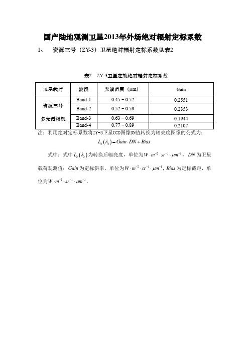
国产陆地观测卫星2013年外场绝对辐射定标系数1、 资源三号(ZY-3)卫星绝对辐射定标系数见表2表2 ZY-3卫星在轨绝对辐射定标系数卫星载荷 波段 光谱范围(μm ) Gain资源三号多光谱相机 Band-1 0.45 ~ 0.52 0.2551 Band-20.52 ~ 0.590.2353Band-30.63 ~ 0.69 0.1944 Band-4 0.77 ~ 0.89 0.2107注:利用绝对定标系数将ZY-3卫星CCD 图像DN 值转换为辐亮度图像的公式为:()e e L Gain DN Bias λ=⋅+式中:式中()e e L λ为转换后辐亮度,单位为211W m sr m μ---⋅⋅⋅,DN 为卫星载荷观测值;Gain 为定标斜率,单位为211W m sr m μ---⋅⋅⋅,Bias 为定标截距,单位为211W m sr m μ---⋅⋅⋅。
2、 资源一号02C (ZY-1 02C )卫星绝对辐射定标系数见表3表3 ZY-1 02C 星CCD 相机的定标系数卫星载荷波段号GainBiasZY-1-02C-PMSBand1(P)0.6208 -13.826 Band2 0.7397 -22.246 Band3 0.6904 -15.438 Band40.6369-14.201注:利用绝对定标系数将ZY-1 02C 卫星CCD 图像DN 值转换为辐亮度图像的公式为:()e e L Gain DN Bias λ=⋅+式中:式中()e e L λ为转换后辐亮度,单位为211W m sr m μ---⋅⋅⋅,DN 为卫星载荷观测值;Gain 为定标斜率,单位为211W m sr m μ---⋅⋅⋅,Bias 为定标截距,单位为211W m sr m μ---⋅⋅⋅。
3、 环境减灾-AB (HJ-1A/B )卫星绝对辐射定标系数见表4表4 HJ-1A/B 星CCD 相机(增益2)的定标系数卫星载荷波段号 Gain Bias HJ-1A-CCD1Band11.2944 13.4450 Band2 1.2878 6.7172 Band3 0.9875 -4.5131 Band4 0.9822 -1.7140 HJ-1A-CCD2Band11.1185 -9.9414 Band2 1.2049 -16.773 Band3 0.8384 -21.915 Band4 0.9257 -27.660 HJ-1B-CCD1Band10.9838 42.619 Band2 0.9983 35.264 Band3 0.7528 22.192 Band4 0.7538 11.214 HJ-1B-CCD2Band11.0649 4.417 Band2 1.1644 -5.503 Band3 0.8507 -6.7944 Band40.8436-2.9271注:利用绝对定标系数将HJ-1A/B 卫星CCD 图像DN 值转换为辐亮度图像的公式为:()e e L Gain DN Bias λ=⋅+式中:式中()e e L λ为转换后辐亮度,单位为211W m sr m μ---⋅⋅⋅,DN 为卫星载荷观测值;Gain 为定标斜率,单位为211W m sr m μ---⋅⋅⋅,Bias 为定标截距,单位为211W m sr m μ---⋅⋅⋅。
- 1、下载文档前请自行甄别文档内容的完整性,平台不提供额外的编辑、内容补充、找答案等附加服务。
- 2、"仅部分预览"的文档,不可在线预览部分如存在完整性等问题,可反馈申请退款(可完整预览的文档不适用该条件!)。
- 3、如文档侵犯您的权益,请联系客服反馈,我们会尽快为您处理(人工客服工作时间:9:00-18:30)。
Indeed, Satellite Derived Bathymetry (SDB) is one of the main areas of research in the field of the RS of the marine environment considering the numerous practical applications: monitoring underwater topography, movement of deposited sediments and production of maritime charts for navigation [1].
Keywords: bathymetry; SDB; WorldView-3; spectic correction; remote sensing.
1. Introduction
Based on the statistical relationships between satellite image pixel values and field measured water depth measurements, several methods in Remote Sensing (RS) environments have been developed in order to obtain bathymetric data of a specific area of study.
Claudio Parente, Massimiliano Pepe
Acta Polytechnica
Figure 1. Wavelengths of PAN and MS of WV-3 satellite data in the ranges from 400 to 1040 nm
Figure 2. SDB workflow.
Regarding radiometric aspects, the WV-3 acquires 11-bit data in 9 spectral bands covering panchromatic and multispectral bands. The single-wavelength band for a PAN image is 450–900 nm while the MS images have eight wavelength bands (Figure 1): Coastal (B1:
2. Data and method
2.1. WorldView-3 data
The latest generation of commercial satellite sensors provides images with a Very High geometric Resolution (VHR), i.e., images with metric and sub-metric spatial resolution. An example of the VHR commercial satellite is the WorldView-3 (WV-3). It collects data with a nominal ground sample distance of 0.31 m (panchromatic), 1.24 m (multispectral) and 3.7 m (Shortwave Infrared — SWIR) at nadir configuration [8, 9]. However, the commercial images are resampled to 0.3 m (PAN), 1.2 m (MS) and 7.5 m (SWIR).
Abstract. The use of optical satellite sensors allows to obtain bathymetry data on large area in a short time and in a cheap way. In addition, in particular places where it is difficult to carry out the survey by classic methods, the bathymetry from satellite data can be the only mode to obtain the depth of the backdrop. So, the aim of this research paper is to analyse the potential of the eight bands and the very high resolution of the commercial satellite WorldView-3 (WV-3) in order to obtain bathymetric data.
The comparison between the results and the reference bathymetric data shows a huge potential of the WV-3 satellite data. The area of study concerns the port area of the city of Lisbon and a part of the river Rio Tejo, in Portugal.
geometric resolution obtained with this new satellite sensor (WV-3), in order to construct bathymetric maps.
The paper is organized as follows. The section entitled “Data and methods” illustrates the characteristics of the WV-3 images and the methods present in literature in order to determine the depth of water by satellite imagery. Subsequently, a suitable workflow is identified in order to obtain bathymetric data. The section “Application of the method on the area of study” explains, by a case study, the accuracy of the bathymetry obtained by WorldView-3 satellite image. Conclusions are summarized at the end of the paper.
Over the years, different empirical models have been developed in the SDB application, largely connected to the evolution of satellite platforms [2]. In this way, several studies on the ability to estimate depth from a satellite image have been realized using Landsat TM [3], SPOT [4] and QuickBird [5] images. Most recently, DigitalGlobe’s WorldView-2 satellite sensor (WV-2), allowed the estimation of water depths thanks to the ability of this sensor to acquire eight bands with a high geometric resolution. In particular, the coastal band, whose wavelength varies from 400 to 450 nm, improves the quality of the bathymetric measure [6]. Indeed, this part of the spectrum provides the deepest penetration of water. Subsequently, in August 2014, the WorldView-3 satellite was launched with a sensor on board that is able to acquire images in eight bands, in a way similar to the WV-2 satellite, but with a greater resolution in the Panchromatic (PAN) and Multispectral (MS) mode [7]. Therefore, considering the good results obtained with the WV-2 sensor, in this paper, we investigate the impacts of the high