地理信息科学专业英语
地理信息技术名称和缩写

地理信息技术是一门综合性技术领域,包括地理信息系统(GIS)、遥感(RS)、全球定位系统(GPS)和数字地球技术等。
以下是一些常见的地理信息技术名称及其缩写:1. 地理信息系统(Geographic Information System或GeoInformation system,GIS)- GIS是最常见的地理信息技术之一,它用于捕获、存储、管理、分析和展示地理空间数据。
2. 遥感(Remote Sensing,RS)- 遥感是通过分析从飞机或卫星收集的遥远地区的数据来获取信息的技术。
3. 全球定位系统(Global Positioning System,GPS)- GPS是一个全球性的导航系统,用于确定地球上的任何位置的精确坐标。
4. 数字地球技术(Digital Earth Technology)- 数字地球技术涉及创建数字模型来模拟地球的表面和地下结构,以便于研究和决策。
5. 地理信息系统协会(Association of American Geographers,AAG)- AAG是一个专业组织,致力于地理学的研究和地理信息技术的应用。
6. 欧洲地理信息系统协会(European Geodetic Union,EUG)- EUG是一个欧洲范围内的组织,专注于地理信息和地球观测的研究与应用。
7. 国际地理联合会(International Geographical Union,IGU)- IGU是一个国际性的地理学学术组织,涵盖地理学研究和地理信息技术的应用。
8. 地理信息科学(Geographic Information Science,GIScience)- GIScience是研究地理信息系统的科学基础,包括数据模型、分析方法和理论。
这些技术和组织在地理信息的管理、分析和应用中发挥着重要作用,支持着各种领域的决策制定和科学研究。
GIS专业英语教学教材
G I S专业英语第一课Comprehensive:全面的,综合的,Intellectual:智力的,才智的Jargon:专业术语Terminology:专业术语Geomatique:地理信息技术Geoscience:地球科学Derivative:派生物,衍生物Cartography:地图绘制学,地图绘制Architect:建筑师Preliminary:初步的,起始的Enumerate:列举,枚举Resemble:像,与……相似Transformation:转换第二课Automated:自动化的Equivalent:a等价的Cartographer:绘制图表者,制图师Mylar:胶片Electronic:电子的Encode:编码Orthophotoquad:正射影像图Aerial:空中的,航空的Aggregation:集合,聚合,集合体Reproduction:再现,复制,繁殖Dissemination:传播,宣传,传染Counterpart:相似之物Compactness:致密性Complexity:复杂,复杂性Hamper:阻碍,束缚Retrieval:取回,恢复,修补Analog:模拟的Planimeter:测面器,求积仪Phenomena:现象Quantitative:数量的,定量的Histogram:直方图,柱状图Supplementally:追加,补充Modification:修改,变型Cartogram:统计地图,统计图Hand-drawn:手绘Emergency:紧急事件Employe:雇佣,雇工Clarify:澄清,阐明Taxonomy:分类学,分类法Bifurcation:分歧,分叉Parcel:地块Conservation:保存,保持Procurement:获得,取得,采购Wildlife:野生动植物Earthquake:地震Landslide:泥石流,山崩Cadastral:地籍的,有关土地清册的Geodetic:大地测量学,最短线的Sophisticated:精致的,复杂的第三课Pervade:弥漫,遍及Aspect:坡向,方向,面貌Inevitable:必然的,不可避免的Proprietary:所有的,专利的Mineral:矿物的,矿质的Military:军队,军人Electricity:电力,电流Telecommunication:通讯,电信学Interconnect:使相互连接,相互联系Administrative:管制的,行政的Environmental:环境的,周围的Attribute:属性,特质Procedure:步骤,程序,手续Manipulation:操作,操纵,处理Historically:历史上地,Subsume:把…..归入,把…..包括在Eclipse:形成蚀,使黯然失色Visualization:可视化,Immense:巨大的,广大的Analogue:类似,相似物Conventional:常见的,惯例的Enquire:询问,打听Coniferous:松柏科的Highlight:强调,突出,Stress:强调,加压力与Derive:得到,源于Discipline:纪律,学科,惩罚Algorithm:算法,Interpret:说明,口译,解释Artificial:人造的,仿造的,虚伪的Geomatique:地理信息技术Cartography:地图绘制学,地图绘制Preliminary:初步的,起始的Cartographer:绘制图表者,制图师Encode:编码Aggregation:集合,聚合,集合体Retrieval:取回,恢复,修补Analog:模拟的Quantitative:数量的,定量的Histogram:直方图,柱状图Cartogram:统计地图,统计图Parcel:地块Geodetic:大地测量学,最短线的Cadastral:地籍的,有关土地清册的Attribute:属性,特质Procedure:步骤,程序,手续Prime meridian:本初子午线Algorithm:算法,Discipline:纪律,学科,惩罚Visualization:可视化,Globe;球体Map projection地图投影Planar projection;平面投影Azimuthal projection;方位投影Characteristic,特征,特性Reference globe;参考椭球体Scale factor;比例因子Principle scale;主比例尺Equivalent projection;等积投影Equidistant;等距投影Mercator transverse;横轴莫卡托投影Gnomonic protection;中心切面投影Lambert‘s equal area projection 兰伯特等级方位投影Intelligence:智力,理解力,Correlation:相关,关联Urban:城市的Agriculture:农业,农艺Adjunct:附属物,修饰语Subdiscipline:学科的分支,副学科第四课Globe;球体Illustrate;阐明Configuration;配置,结构,外形Thematic;主题的Encounter;遭遇;邂逅Map projection地图投影Cylindrical;圆柱形的Projection family;投影系Planar projection;平面投影Cylindrical projection;圆柱投影Conical projection;圆锥投影Azimuthal projection;方位投影Community,社区,团体Representation;表现,陈述Characteristic,特征,特性Retain;保持,记住Convert;使转变Reference globe;参考椭球体Principle scale;主比例尺Scale factor;比例因子Cardinal 主要的,基本的Angular conformity;角度一致Conformal;等角的Orthomorphic;正形的Equivalent projection;等积投影Fundamental;基本的Equidistant;等距投影Maintain;维持,维修,供养Standard parallel;标准纬线Vital;生死攸关的,至关重要的Preservation;保存,保留Mercator transverse;横轴莫卡托投影Shopping mall ;大卖场Lambert‘s equal area projection 兰伯特等级方位投影Stereographic;立体照相的Orthographic;直角的Georeference;地理坐标参考系Universal transverse Mercator;通用横莫卡托投影Data type;数据类型,资料类型Attribute;属性,性质Vector;矢量Raster:光栅Langscape;地表,地形Vertex;顶点,头顶Arc;弧形物,弧Node;节点Topology;拓扑学Vector-raster conversion矢量-栅格转换Quadtree;四叉树Computer-aided drafting;计算机辅助制图Orthophoto;正色摄影Map algebra地图代数Forestry stand;林地,林区Inappropriate;不适当的,不相称的Quantized:量化的Legend:传奇,图例Vegetation:植物,草木Geological:地质的Spatial:空间分析技术Binary:二元的,二进制的Residence:居住,住处Variable:易变的,多变的Run-length code:长度方向编码Subsystem:子系统Pattern:样式,模式Scheme:模式,设计Database:数据库Resolution:解析,决议Entity:实体Spaghetti model:面条模型Topological model:拓扑模型Coordinate:坐标From node:终点Intersect:交叉,相交Form node:起始点Graph theory:图论Analog:模拟地图Compact:紧密的Reduction:缩减,降低Codification:编码,译成代码Shorthand:速记法Theme:题目,主题Scheme:模式,计划Gnomonic protection;中心切面投影Coordination;对等,同等第五课Georeference;地理坐标参考系Ellipsoid;椭圆,椭面Department of defence;国防部Universal transverse Mercator;通用横莫卡托投影第六课Thematic;题目的,主题的Facilitate;促进,帮助Data type;数据类型,资料类型Animation;活泼生气,激励Attribute;属性,性质Narration;叙述,讲述Vector;矢量Raster;光栅Image;影像,肖像Photograph;照片,相片Langscape;地表,地形Vertex;顶点,头顶Arc;弧形物,弧Node;节点Connectivity;连通性,互联性Topology;拓扑学Mathematical;数学的,数学上的Adjacency;毗邻,四周Computer-aided drafting;计算机辅助制图Gridcell;格网单元Tesseate;棋盘格网的Quadtree;四叉树Data volume;数据卷Cumbersome;笨重的Vector-raster conversion矢量-栅格转换Imperative;必要的,势在必行的Map algebra地图代数Modeling;造型的Distinguish;区别,区分Orthophoto;正色摄影Ancillary;辅助的,Rectify;改正Summarize;总结,概述Aesthetically;审美的Continuous;连续的,持续的Filtering;过滤,滤除Idelally;理想的,观念上Descrete;离散的,不连续的Forestry stand;林地,林区Accommodate;供应,容纳Integrity;完整性,正直Inappropriate;不适当的,不相称的第七课Quantized:量化的Coverage:覆盖Legend:传奇,图例Vegetation:植物,草木Geological:地质的Efficient:有效的,生效的Awkward:笨拙的,尴尬的Checkerboard:棋盘Similarity:类似,相似点Recreation:娱乐,消遣Residence:居住,住处Variable:易变的,多变的Primary:主要的Eliminate:消除,排除Intuitive:直觉Binary:二元的,二进制的Accomplished:熟悉的,有技巧的Retrieve:检索的Manipulation:操纵,操作Mainframe:主机,Workstation:工作台,工作站Flexibility:弹性,灵活性Transparent:透明的,显然的Strengthening:强化,加固Linkage:连接,联系Spatial:空间分析技术Maturing:成熟第八课Run-length code:长度方向编码Compacting:压缩,精简Approach:方法Subsystem:子系统Acetate:一种透明胶片Numerical:数字的,数值的Giggling :轻笑,傻笑Humility:谦逊的Workload:负载,工作量Pattern:样式,模式Scheme:模式,设计Cumbersome:笨重的,难使用的Respectively:各自的,分别的Homogeneous:各种的,相似的Quadrant:四分之一Variable:变量的,易变的Resolution:解析,决议Subdivision:细分,子部Multiple:多个的,多种的Database:数据库第九课Reminiscent:提示的,怀旧的Entity:实体Implicit:隐式的,内含的Explicit:明晰的,明确的‘Intervening:干涉的Spaghetti model:面条模型Topological model:拓扑模型Envision:预见,展望Coordinate:坐标Enormous:巨大的Plotting device:绘图设备Precalculated:预先计算好的Incorporate:集成,包含Contact:接触Intersect:交叉,相交Identification:识别Tedious:冗长的Approximate:接近,使接近Polygon:多边形From node:终点Suffer:遭受Analog:模拟地图Graph theory:图论Portrayal:描述,画像Meandering:曲折的Drawback:缺点第十课Compact:紧密的Reduction:缩减,降低Codification:编码,译成代码Scheme:模式,计划Shorthand:速记法Theme:题目,主题第十一课Majority:大多数Algorithm:算法Plotter:绘图仪Rasterisation:栅格化Vectorisation:矢量化Approximation:近视,概算Pixel:像素Boundary:边界Minimise :使……最小化Sampling:取样Jaggedness:层次不齐Aliasing:扭曲,变形Signal processing:信号处理Counteracting;反作用Continuint;连续性Increment;增长Curve;曲线Neighbouring polygon相邻多边形Allocating;分配Areal;面积的Context,上下文,环境Dominant;重要的,强大的Clipped;裁剪的Rounding;圆的Associated;联合的Predict;预测Coherence;连贯性,相关性Aberration;偏离,偏差Strategy;策略Assumption;假定,臆断。
地理信息科学专业英语书后单词

Spatial interpolation 空间插值 standard query language(SQL)标准化查询语言
Polygon 多边形 proximity analysis 邻近域分析
Data structures 数据结构 information retrieval 信息检索
Topological modeling 拓扑建模 network analysis网络分析
Overlay 叠置 data output 数据输出
7、remote sensing 遥感 பைடு நூலகம் sensor 传感器
Electromagnetic radiation 电磁辐射 radiometer 辐射计
Electro-optical scanner 光学扫描仪 radar system 雷达系统
high resolution visible(HRV)sensors 高分辨可视成像传感器
Charge-coupled devices (CCDs)电荷耦合器件
panchromatic(PLA)全色 multispectral(MLA)多波段
WFI(Wide Field Imager)广角成像仪 earth observing system(EOS)地球观测系统
CBERS(China-Brazil Erath Resources Satellite)中巴地球资源卫星
IRMSS(Infrared Multispectral Scanner) 红外多光谱扫描仪
Disaster management 灾害管理 public health 公共卫生
地理信息科学专业英语

主讲:钱建国
这几组词你能读的准吗?
1. shit 和sheet ,ship和sheep 2.word和world 3.thumb和sum 4.house和horse 5.vest和west 6.east和yeast,ear和year
多数情况下,可能由于儿化音的影响,也是受美语的影响, 我们喜欢不自觉的卷舌发一些元音,其实元音都不是卷舌的, 只是舌位的高低不同而已。
2.表示数量关系的前缀
1)表示“单一”,“一” mon-, mon-, monotone(单调),monopoly, monarch uni-, un-, uniform, unicellular(单细胞)
2)表示“二,两,双” ambi-, ambiguous, amphibian(两栖类) bi-, bicycle di-, diode(二级管) 3)表示“十” deca-, deco-, dec- deci-, decade, decimals 4)表示“百,百分之一” hecto-, hect-, hectometer(百米), centi-, centimeter(分米)
26)带有学术,科技含义
-grapy,表示"…,写法” biography, calligraphy, geography -ic, -ics,表示"…学…法" logic, mechanics, optics, electronics -ology,表示"…学…论”biology, zoology, technology(工艺学) -nomy,表示"…学…术" astronomy, economy, bionomy(生态 学) -ery,表示"学科,技术" chemistry, cookery, machinery -y,表示"…学,术,法” photography, philosophy
GIS专业英语词汇
Addres s mat ching一种用来在两个使用地址的文件将进行关联的机制。
地理坐标和属性可以从一个地址转换成另一个。
举例来说,一个学生包含地址的文件可以映射到一个街道图层上,该图层包含了学生居住点的点图层的地址。
ADS弧段数字化系统。
一种数字化和编辑的简单系统,用来向图层上添加弧段和标签点。
A lloca tion在最大阻抗或资源容量范围内于网络终止拍到最近中心的弧段的过程。
AM/FM是英文Auto mated Mapp ing/F acili tiesManag ement的缩写,是一种基于地理信息上的设备和生产技术管理的计算机图文交互系统,也是一种将图形技术与数据库管理技术相结合的计算机应用软件系统,采用AM/FM系统,能实现输配电网络系统的规划、建设、报装、调度、运行、检修和营业用电的计算机辅助管理,是目前在公共事业单位对分散设备(相对发电厂、钢厂等在地理上相对集中的集中设备而言)进行计算机辅助管理的先进、实用和理想的应用软件系统。
AM/FM系统是在地理信息系统(GI S)的基础上,根据设备工程管理的需要和生产技术管理的要求而开发的一种用于生产运行单位的新的信息管理系统,在很多场合也用AM/FM/GIS来代表AM/FM系统。
Ann otati on1。
对图层特征物进行描述的文本,用来显示而不用于分析.2。
在图层中用来标签其他特征物的一个特征类。
其信息包含一个字符串,字符串显示位置和文本特征信息(颜色,字体,大小等)。
又见TAT。
ANSI美国国家标准组织是一个全国性的标准化协调组织。
也是一个批准与撤消公认标准的组织,ANSI与国际标准组织关系密切,尤其是ISO,共同致力于发展国际标准,因其在当今社会的方方面面的影响,他们在SQL与空间扩展SQL方面的工作引起了GIS界的极大关注。
关于地理科学专业的英语作文
关于地理科学专业的英语作文English Answer:Geography is the scientific study of the Earth's physical and human characteristics and their interrelationships. It is a broad field that encompasses the study of everything from the physical environment, including the atmosphere, hydrosphere, and lithosphere, to the human environment, including the demography, economy, and culture. Geographers use a variety of methods to study the Earth, including field observations, remote sensing, and Geographic Information Systems (GIS).Geographers work in a variety of settings, including academia, government, and the private sector. They conduct research on a variety of topics, including climate change, land use, and environmental hazards. Geographers also use their knowledge to develop policies and plans for managing the Earth's resources.Geography is a fascinating and rewarding field of study. It provides a unique perspective on the Earth and its inhabitants, and it can help us to understand the complex challenges facing our planet.中文回答:地理学是科学地研究地球的自然和人文特征及其相互关系的一门学科。
中英文地理信息系统(GIS)英语词汇表

accreditation 委派accuracy 准确度acquisition 获取activity patterns 活动模式added value 附加值adjacency邻接Aeolian 伊奥利亚人的, 风的, 风蚀的Age of Discovery 发现的年代aggregation聚合algorithm, definition算法,定义ambiguity 不明确analytical cartography 分析制图application programming interfaces(APIs) 应用编程接口ARCGis 美国ESRI公司开发的世界先进的地理信息系统软件ArcIMS 它是个强大的,基于标准的工具,让你快速设计和管理Internet地图服务ArcInfo 在ArcGIS软件家族中,ArcInfo是GIS软件中功能最全面的。
它包含ArcView和ArcEditor 所有功能,并加上高级空间处理和数据转换ArcNews 美国ESRI向用户终生免费赠送的ArcNews报刊ArcSDE ArcSDE在ESRI GIS软件和DBMS之间提供通道,是一个空间数据引擎ArcUser Magazine 为ESRI用户创建的报刊ArcView 桌面GIS和制图软件,提供数据可视化,查询,分析和集成功能,以及创建和编辑地理数据的能力ARPANET ARPA 计算机网(美国国防部高级研究计划局建立的计算机网)aspatial data 非空间数据?Association of Geographic Information (AGI) 地理信息协会attribute data 属性数据attributes, types 属性,类型attributive geographic data 属性地理数据autocorrelation 自相关Autodesk MapGuide 美国Autodesk公司生产的Web GIS软件Automated mapping/facility management(AM/FM) systems 自动绘图/设备管理系统facilities 设备avatars 化身A VIRIS 机载可见光/红外成像光谱仪azimuthal projections 方位投影batch vectorization 批量矢量化beer consumption 啤酒消费benchmarking 基准Berry, Brianbest fit line 最优线binary counting system 二进制计算系统binomial distribution 二项式分布bivariate Gaussian distribution 二元高斯分布block encoding 块编码Bosnia, repartitioning 波斯尼亚,再分离成两个国家buffering 缓冲区分析Borrough, PeterBusiness and service planning(retailing) application in petroleum and convenience shopping 石油和便利购物的业务和服务规划(零售)应用business drivers 业务驱动business, GIS as 业务,地理信息系统作为Buttenfield, Barbaracadasters 土地清册Callingham, Martincannibalizing 调拨Cartesian coordinate system笛卡尔坐标系Cartograms 统计地图cartographic generalization 制图综合cartographic modeling 地图建模cartometric transformations 量图变换catalog view of database 数据库目录视图census data人口普查数据Census of Population 人口普查central Place Theory 中心区位论central point rule 中点规则central tendency 中心倾向centroid 质心choropleth mapping分区制图choosing a GIS 选择一个地理信息系统class 类别classification generalization 分类综合client 客户端client-server C/S结构客户端-服务器cluster analysis 聚类分析clutter 混乱coastline weave 海岸线codified knowledge 编码知识COGO data 坐标几何数据COGO editing tools 坐标几何编辑工具Collaboration 协作Local level 地方级National level 国家级Collection-level metadata 获取级元数据Commercial-off-the-shelf (COTS) systems 成熟的商业化系统chemas-microsoft-comfficeffice" />>> Commom object request broker architecture (CORBA) 公共对象请求代理体系结构Community, GIS 社区,地理信息系统Competition 竞争Component GIS 组件地理信息系统Component object model (COM) 组件对象模型Computer assisted mass appraisal (CAMA) 辅助大量估价,>>Computer-aided design (CAD)-based GIS 基于计算机辅助制图的地理信息系统Models 数据模型Computer-aided software engineering (CASE) tool 计算机辅助软件工程工具Concatenation 串联Confidence limits 置信界限Conflation 异文合并Conformal property 等角特性Confusion matrix 混淆矩阵Conic projections 圆锥投影Connectivity 连接性Consolidation 巩固Constant term 常数项Contagious diffusion 传染扩散Continuing professional development (CPD) 持续专业发展Coordinates 坐标Copyright 版权Corridor 走廊Cost-benefit analysis 成本效益分析Cost-effectiveness evaluation 成本效率评估Counting method 计算方法Cresswell, PaulCustomer support 客户支持Cylindrical Equidistant Projection 圆柱等距投影Cylindrical projections 圆柱投影> >Dangermond, Jack 美国ESRI总裁>> dasymetric mapping 分区密度制图>>data 数据>>automation 自动化>>capture costs 获取代价>>capture project 获取工程>>collection workflow 采集工作流>> compression 压缩>>conversion 转换>>definition 定义>>geographic, nature of 地理数据,数据的性质>> GIS 地理信息系统>>industry 产业>>integration 集成>>mining 挖掘>>transfer 迁移>>translation 转化>>data model 数据模型>> definition 定义>>levels of abstraction 提取等级>> in practice 实际上>>types 类型>>database 数据库>>definition 定义>>design 设计>>generalization 综合>>global 全球的>>index 索引>>multi-user editing 多用户编辑>> structuring 结构>>database management system (DBMS) 数据库管理系统>>capabilities 能力>>data storage 数据存储>>geographic extensions 地理扩展>>types 类型>>Dayton Accord 达顿协定,1995年12月达顿协定(DAYTON ACCORD)签订,巴尔干和平已经实现,波斯尼亚(包括黑塞哥维那)再被分解成两个国家>>decision support 决策支持>>deductive reasoning 演绎推理>>definitions of GIS 地理信息系统的各种定义>>degrees of freedom 自由度>>density estimation 密度估算>>dependence in space 空间依赖>>desktop GIS 桌面地理信息系统>>desktop paradigms 桌面范例>>Digital Chart of the World (DCW) 世界数字化图>>digital divide 数字鸿沟>>Digital Earth 数字地球>>Digital elevation models (DEMs) 数字高程模型>>Digital line graph (DLG) 数字线划图>>Digital raster graphic (DRG) 数字影像图>>Digital representation 数字表现>>Digital terrain models 数字地形模型>>Digitizing 数字化>>DIME (Dual Independent Map Encoding) program 美国人口调查局建立的双重独立地图编码系统>> Dine CARE >>Discrete objects 离散对象>>Douglas-Poiker algorithm 道格拉斯-普克算法,一种矢量数据抽稀算法>>Dublin Core metadata standard 都柏林核心元数据标准>>Dynamic segmentation 动态分割>>Dynamic simulation models 动态仿真模型>>> >Easting 朝东方>>Ecological fallacy 生态谬误>>e-commerce 电子商业>>editing 编辑>>education 教育>>electromagnetic spectrum 电磁光谱>>ellipsoids 偏振光椭圆率测量仪>>of rotation 旋转的>>emergency evacuation 应急撤退>>encapsulation 封装>>environmental applications 环境应用>>environmental impact 环境影响>>epidemiology 流行病学>>equal area property 等面积特性>>Equator 赤道>>ERDAS ERDAS公司是世界上最大的专业遥感图像处理软件公司,用户遍布100多个国家,软件套数超过17000套。
(完整word)测绘专业英语单词

(完整word)测绘专业英语单词Chapter 1Geomatics 测绘学Surveying 测量学Geodesy 测地学Geosciences 地球科学Surveying and mapping 测绘学Surveying and mapping engineering 测绘工程Geoinformatics 地理信息学Geodetic network 大地控制网Land Surveyor 土地测量员Photogrammetriest 摄影测量员Practitioner 从业者Topographic map 地形图Geographic information system 地理信息系统Aerial photogrammetry 航空摄影测量学Remote sensing 遥感Cartography 地图制图学Computer graphics 计算机图形学Global navigation satellite system GNSSGlobal position system GPS Environmental visualization 环境可视化Geographic information system GIS Geographic referenced information 地理参考信息Landforms 地形Underground geological structure 地下地质构造Hydrology 水文学Mineral resources 矿产资源Topographic maps 地形图Geodynamic phenomena 地球动力学现象Polar motion 极移Crustal motion 地壳运动Earth tides 地球潮汐Sphere 球(体)Spheroid 球体Ellipse 椭圆Ellipsoid 椭圆体,椭球Surveying station 测站Geodetic control points 大地控制点With permanent monuments 永久标志Curved surface 曲面Straight line 直线Plane 平面Precise instrument 精密仪器Reference coordinat e 参考坐标Contour maps 等值线图Three dimensional model 三维模型Analog or digital forms 模拟或数字形式Specialized illustration software 专业插图软件Data acquisition 数据获取Data representation 数据表达Manipulate 处理,操作Data storage 数据存储Data preprocessing 数据预处理Longitude latitude altitude 经度、纬度、高度Regional navigation system 地区导航系统Analog photogrammetry 模拟摄影测量Analytical photogrammetry 解析摄影测量Digital photogrammetry 数字摄影测量Plotter 绘图机Passive remote sensing/active remote sensingFilm photography 胶片Infrared sensors 红外感应Charge coupled devices 电荷耦合器件Radiometer 辐射计Backscattered 反向散射Passive/active sensor/reflector 被动/主动传感器/反射器Henan polytechnic university Geographic data 地理数据Reference spheroid 参考椭球体Curved surface 曲面Analogy form 模拟模式Radio signal 无线信号Laser 激光(完整word)测绘专业英语单词Chapter 2Analog forms 模拟形式Paper plan 平面图Report table 报告表Three dimensional mathematical model 三维数学模型Horizontal and vertical distances 水平距离和垂直距离Determining Elevations 确定高程Direction 方向Location 位置Volume 体积(量)Portray graphically生动描绘Profile/cross section 侧面/横断面Longitudinal section 纵剖面Diagram 图表/示意图Optical theodolite 光学经纬仪Digital level 数字水准仪Electronic Distance Measurement (EDM)Total station 全站仪Aerial photogrammetry 航空摄影Satellite observation 卫星观测Inertial surveying 惯性测量Laser ranging techniques 激光测距技术Large volume of data 大量数据Rigorous processing 严密加工工艺Field/office work 野外/室内工作Conventional construction engineering projects 传统建设工程项目Property surveying 权属调查Geology 地质学 geophysics地球物理biology生物 agriculture 农业forestry 林业 hydrology 水文oceanography 海洋学Geography地理学Distance measurement 距离测量Linear 线性物 non-Spherical earth 球面地Slant 倾斜Tape 卷尺Telescope view望远镜视场electro-optical distance measuring 光电测距Earth gravity field 地球重力场Plume lines 铅垂线plastic tapes 塑料尺Poly tapes 塑料尺Steel types 钢尺Marking pole 花杆marking pin 测杆spring balance 弹簧秤Collimation axis 视准轴plumb bob 铅锤Invar tapes 因瓦尺Coefficient 系数Metric units 米制单位Foot units 英制单位Metric 公制,米制Meter 米Decimeter 分米Centimeter 厘米Minimeter 毫米Kilometer 千米Tacheometry 视距测量Theodolite tacheometryoptical resolutionOrdinary taping 普通丈量Precise taping 精密丈量Thermal expansion 热膨胀fixed-angle intercept截取一个固定角stadia interval factorstadia system 视距系统level rod 水准尺Plane table 平板仪line of sight 视线horizontal stadia principle 水平视距原理stadia interval 视距间隔 factor 常数stadia hairs 视距丝Principle focus 主焦点detail surveys 碎步测量topographic surveys 地形测量Leveling 水准测量electronic distance measurement 电子测距仪Geodimeter Inc光电测距仪公司terrain conditions 地形条件(完整word)测绘专业英语单词Radio waves 无线电波Identical velocities 相同速度Light velocity 光速Vacuum 真空operational range 测距Microwave systems 微波系统Light wave systems 光波系统Infrared systems 红外系统Wavelength band 波段Transmitted signals 传播信号airborne particles 浮尘Traversing 导线测量Precise taping 精密丈量Curvature 曲率Mean sea level MSLPermanent points/benchmarks 基准参照Trigonometric or indirect leveling 三角高程测量direct or spirit leveling 水准测量stadia leveling 视距测量different leveling 差分水准Point in question 待求点self-reducing tacheometer 自降速测仪Barometric leveling 气压高程测量Gravimetric leveling 重力高程测量mutually perpendicular axes Standard deviations 标准差earth curvature and refraction Annexed leveling line 附和水准路线spur leveling line 支水准路线closed leveling line 闭合水准路线preclude 排除slope distance 斜距vertical angle 竖直角Zenith angle 天顶角National vertical datum 国家高程基准theodolite 经纬仪 transitangles of elevation 仰角 minus anglesangles of depression 俯角 down anglesreciprocal vertical angle observation 垂直角对测degree minute second 度分秒the sexagesimal system 六十进制系统radian 弧度topographic detail points 地形碎部点points to be set out 待放样点clinometer 测角仪/倾斜仪sextant 六分仪compass 罗盘true meridian direction 真子午线方向true north direction 正北方向meridian plane 子午面gyro theodolite 陀螺经纬仪magnetic meridian direction 磁北方向azimuths 方位角coordinate north direction 坐标北方向coordinate axies direction clockwise direction 顺时针方向counterclockwise direction 逆时针方向bearing/orientation 方位、方向quadrant 象限horizontal circle 水平度盘circular protractors 圆形量角器geometric conditions 几何条件astronomic 天文学的,极大的magnetic poles 磁极gauss coordinate system 高斯坐标系coordinate azimuth 坐标方位角meridian 子午圈/线azimuthal projection 方位角投影commencing on 开始face left 盘左bisected bisect 一分为二binary 二进制的horizontal scale 水平度盘比例尺upper plate clamp 上盘制动夹subtract 减法,扣除arbitrary points 任意点primary control 一级控制triangulation 三角法trilateration 三边法intersection 交会法resection 后方交会traversing 导线测量trigonometric proposition 三角定理law of sines 正弦定理(完整word)测绘专业英语单词law of cosines 余弦定理forward intersection 前方交会side intersection 侧方交会steel tapes 钢尺hydrographic surveyspur/stub traverse 支导线geometric closure 几何形状闭合connection/annexed traverse 附合导线Closed traverse 闭合导线Normal calculation 坐标正算inverse calculation 坐标反算Stadia hair 视距丝Cross hair 十字丝Pulse method 脉冲法Phase different method 相差法Modulated light beam 调制光束Dividing scale tape 刻线尺Reflect 反射disperse散射 radiate 辐射Refract折射 diffract 衍射 diffuse 漫射Compensator 补偿器Ralative precision 相对精度Absolute precision 绝对精度Horizontal distance 水平距离Benchmark 水准基准点Alidade 照准部Automatic level 自动安平水准仪Nominal factor 名义因子Construction maps 施工图Air density 空气密度Horizontal braking screw 水平制动螺旋Charpter 3plane trigonometry 平面三角orthogonal projection 正射投影reference ellipsoid 参考椭球面geoid 大地水准面landmass 陆地equipotential surface 等势面theoretical surface 理论面perpendicular 垂直gravity potential 重力势planimetric position 平面位置orthometric heights 正高Geodetic height 大地高semi-major axis 长半径minor axis 短轴plumb bob line 垂线spirit bubble 水准泡horizontalized 使整平flattening 扁率ellipsoidal/geodetic distance 大地距best fitting 最佳拟合global geocentric ellipsoid 全球地心参考系geodetic reference system 1980 大地测量参考系portrary 描绘conformality 正形性at expense of 以牺牲—为代价Arbitrary projection 任意投影Equidistant projection 等距投影Easel plane 承影面Cylindrical projection 圆柱投影Conic projection 圆锥投影Azimuthal/planar projection 方位投影Normal/regular axis tangent conic projection正轴切圆锥投影Normal/regular axis secant conic projection(完整word)测绘专业英语单词正轴割圆锥投影Tangent planar projectionNormal axis tangent planarprojection正轴切面投影Transverse axis tangent planarprojection横轴切面投影Oblique axis tangent planarprojection斜轴切面投影Graticule of normal conic projection 正轴圆锥投影格网Cylinder 圆柱体Gauss kruger projection=conformal(equal angle)transverse tangent elliptic cylindrical projectionUniversal transverse mercator UTM Rules of thumb 经验法则Geodetic datum 大地测量基准World geodetic system 84Standard parallels 标准纬线Meridian 子午线,子午圈,经线Mass anomaly质量异常Geodetic latitude 大地维度Geodetic longitude 大地经度Translation parameter 平移参数Rotation parameter 旋转参数Scale parameter 尺度参数Rotation axis 旋转轴Backsight 后视Leveling rod reading 水准尺读数Height difference 高差Notional leveling origin 国家水准原点Coordinate conversion 坐标转换Smooth surface 光滑表面Normal calculation 正算Normal line 法线Survey specification 测量规范Dimension of the ellipsoid 椭圆的尺寸Chapter 4Direct measurement 直接测量Geometric formulas 几何公式Three broad categories 三大范畴Blunders/mistakes=gross errors Systematic errors 系统误差Magnitude 量级Algebraic sign 代数符号Calibration 校准,标准化Random errors 随机误差Gaussian distribution 高斯分布Law of probability 概率Most probable value 最或然值Points of inflexion 拐点Square root 平方根Probability density function 概率密度函数Normal error distribution curve 正态分布曲线Normal random variable 正态随机变量Frequency histogram 频率直方图Standard deviation 标准差Arithmetic mean 算术平均值Error propagation 误差传播Partial derivative 偏导数Mean square error 中误差Least squares adjustment 最小二乘平差Superfluous measurement 多余测量Instrumental error 仪器误差Redundant measurement 冗余误差Optimal combination 最优组合Matrix/array 矩阵Functional model 函数模型Stochastic model 随机模型Statistical properties 统计特性(完整word)测绘专业英语单词Variance/covariance matrix 方差/协方差矩阵Weighting matrix 权阵Weihted adjustment 加权平差Conditional adjustment 条件平差Parametric adjustment 参数平差Algebraic sum 代数和Geometric check 几何检核Chapter 5Cartography 地图制图学Map compilation 地图编制Map decoration 地图整饰Contour map 等高/值线图Neat line 图表边线Coordinate gratitude/grid 坐标网格Inset 嵌图Bar scale 图解比例尺Thematic map 专题图Topographic map 地形图topological map 拓扑地图Electronic map 电子地图Analytic stereo plotter 解析立体绘图仪Data visualization 数据可视化Image processing 图像处理Spatial analysis 空间分析Specialized illustration software 专门插图软件Laser rangefinders 激光测距仪Computer aided design CAD 计算机辅助设计VectorRasterGeometrical principles 几何原理Geospatial information 地理空间信息Zoom in 放大 out 缩小Graphic scale bar 图解比例尺Map page space 图面空间C++ application programming interface API Chapter 6Global navigation satellite system GNSSGlobal position system GPSOrbital plane 轨道平面Orbital altitude 轨道高度Medium earth orbit /MEO 中地球轨道Carrier wave 载波Absolute positioning 绝对定位Relative positioning 相对定位Static positioning 静态定位Dynamic positioning 动态定位Base station 基站Real time kinematic RTK 实时动态定位Antenna 天线Post processing 后处理Ground based transmitter 地面发射机Geostationary orbit 对地静止轨道GPS receiver GPS接收机Monitor station 监控站Mobile /Roving station 流动站Differential GPS。
地理信息科学专业英语
专业术语英译汉affine 仿射band 波段cartography 制图学clip 剪切digitizer 数字化仪DLG 数字线划图dpi 每英寸点数edgematching 边缘匹配equator 赤道equiarea 等积geoid 大地水准面geospatial 地理空间GPS 全球定位系统Habitat 栖息地Interface 接口Item 项目Latitude 纬度legend 图例longitude 经度median 中值meridian 子午线metadata 元数据neatline 图廓线Object-Based 基于对象的parcel 宗地photogrammetry 摄影测量precipitation 降水量range 范围raster 栅格resample 重采样resolution 分辨率RMS 均方根scanner 扫描仪siting 选址TIGER 拓扑统一地理编码topology 拓扑tuple 数组UTM 通用横轴墨卡托投影vector 矢量专业术语汉译英保护区protected area比例尺Scale bar标准差Standard deviation标准图幅Standard picture frame 单精度Single precision地理空间数据Geospatial data点缓冲区Point buffer动态分段Dynamic segmentation度量标准Metrics多项式变换Polynomial transformation 高程基准Elevation base跟踪算法Tracking algorithm规则格网Rules grid过渡带Transition zone基于位置服务Based on location service畸形线Malformation line几何变换Geometric transformation 检验图Inspection chart解析几何Analytic geometry空间要素Space element平面坐标系统Planar coordinate system曲流河Meandering river人口普查地段Census Lot上四分位数The upper quartile矢量数据模型Vector data model数据可视化data visualization数据探查Data exploration双精度Double precision水文要素Hydrological elements泰森多边型Tyson Polygons统一建模语言Unified Modeling Language投影坐标系统Projection coordinate system 线缓冲区Line buffer遥感数据Remote sensing data用材林Timber forest晕渲法Halo rendering method 指北针Compass属性表Property sheet最短路径分析Shortest path analysis最小二乘法Least squares method翻译例子如下。
山东交通学院各二级学院专业中英文对照
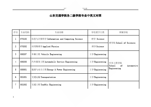
1山东交通学院各二级学院专业中英文对照序号 专业代码 专业名称学位授予门类 所属学院1070102信息与计算科学Information and Computing Science理学 Science理学院School of Sciences2070202应用物理学Applied Physics理学Science3 080207 车辆工程 Vehicle Engineering 工学Engineering汽车工程学院School ofAutomotiveEngineering4 080208 汽车服务工程Automobile Service Engineering工学Engineering 5 080501 能源与动力工程Energy & Power Engineering工学Engineering 6 081801 交通运输Transportation 工学Engineering7 081802 交通工程Traffic Engineering 工学Engineering28 080905 物联网工程Internet of Things Engineering 工学Engineering交通与物流工程学院School of Transportation &Logistics Engineering 9 081806T交通设备与控制工程Transportation Equipment and Control Engineering 工学Engineering10 082901安全工程Safety Engineering工学Engineering11 120602 物流工程Logistics Engineering 工学Engineering12 080802T 轨道交通信号与控制Track Traffic Signal and Control 工学Engineering轨道交通学院School ofRailTransportation 13 081801 交通运输Transportation 工学Engineering 14 080801 自动化Automation工学Engineering15 080202 机械设计制造及其自动化Mechanical Design, Manufacture & Automation 工学Engineering工程机械学院 School ofMechanicalEngineering 16 080203材料成型及控制工程Materials Processing & Controlling Engineering 工学Engineering17 080205工业设计Industrial Design工学Engineering18 080204 机械电子工程Mechatronics Engineering 工学Engineering19 080201 机械工程Mechanical Engineering 工学Engineering20 080601 电气工程及其自动化Electrical Engineering and Automation工学Engineering信息科学与电气工程学院School of InformationScience & ElectricalEngineering21 080701 电子信息工程Electronic Information Engineering 工学Engineering22 080905 物联网工程Internet of Things Engineering 工学Engineering23 080901 计算机科学与技术Computer Science and Technology 工学Engineering24 120102 信息管理与信息系统Information Management and Information Systems12级及以前为:管理学management13级及以后为:工学Engineering25 070504 地理信息科学Geographical Information Science 理学Science 交通土建工程学院School of Civil Engineering 26 081001 土木工程Civil Engineering 工学Engineering327 081005T 城市地下空间工程Urban Underground Space Engineering 工学Engineering28 081103 港口航道与海岸工程Harbour, Waterway and Coastal Engineering工学Engineering29 081201 测绘工程Geodesy and Geomatics Engineering 工学Engineering30 120103 工程管理Construction Management 12级及以前为:管理学management 13级及以后为:工学Engineering31 081202 遥感科学与技术Remote Sensing Science and Technology 工学Engineering32 080401 材料科学与工程Materials Science and Engineering 工学Engineering33 080406 无机非金属材料工程Inorganic Non-metallic Materials Engineering工学Engineering34 050201 英语English Language & Literature 文学Arts外国语学院School of Foreign Studies 35 050202 俄语Russian Language and Literature 文学Arts4536 050207 日语Japanese Language and Literature 文学Arts37 080901 计算机科学与技术Computer Science and Technology 工学Engineering38 020301K 金融学Finance 经济学Economics经济与管理学院School of Economy &Management39 120204 财务管理 Financial Management 管理学Management40 120207 审计学Auditing 管理学Management41 120801 电子商务Electronic Business管理学Management 42 120202 市场营销Marketing管理学Management 43 120401 公共事业管理Public Affairs Management 管理学Management44 120402 行政管理 Public Administration 管理学Management45 120903 会展经济与管理Exhibition Economy and Management管理学Management46 120407T 交通管理Traffic Management 管理学Management47 030101K 法学Law 法学Law 交通法学院School of Transportation Law48 130502 视觉传达设计Visual Communication Design 艺术学Arts艺术与设计学院School of Art & Design 49 130503 环境设计Environmental Design 艺术学Arts50 130504 产品设计Product Design 艺术学Arts51 082003 飞行器制造工程Flight Vehicle Manufacturing Engineering工学Engineering航空学院School of Aeronautics52 080701 电子信息工程Electronic Information Engineering工学Engineering53 082002 飞行器设计与工程Flight Vehicle Design and Engineering工学Engineering54 081803K 航海技术Navigation Technology 工学Engineering 航海学院School of Navigation6755 120408T 海事管理 Maritime Management 管理学Management56 081804K 轮机工程Marine Engineering 工学Engineering船舶与轮机工程学院School of Shipping & Marine Engineering57 081901船舶与海洋工程Naval Architecture and Ocean Engineering工学Engineering58 081808TK船舶电子电气工程Ship Electrical and Electronic Engineering工学Engineering59 080204 机械电子工程Mechatronics Engineering 工学Engineering60 120801 电子商务Electronic Business 管理学Management国际商学院School of International Business61 120407T 交通管理Traffic Management 管理学Management62 080601 电气工程及其自动化Electrical Engineering and Automation工学Engineering国际教育学院School of InternationalEducation63 081801 交通运输Transportation 工学Engineering8。
地理信息系统专业英语

1.Where does the word Geomatics come from? GEODESY+GEOINFORMATICS =GEOMATICS or GEO –for earth and –MATICS for mathematical or GEO- for Geoscience and –MATICS for informatics. It has been said that geomatics is many things to many people . The term geomatics emerged first in Canada and as an academic discipline; it has been introduced worldwide in a number of institutes of higher education during the past few years, mostly by renaming what was previously called “geodesy” or “surveying”, and by-adding a number of computer science- and/ or GIS-oriented courses.地质这个词在哪里地质从何而来?大地测量+教育或地理=地球,地球和-双语对照查看数学或地理-双语对照查看地质灾害与信息学。
有人说地球对于许多人来说意味许多东西。
地球这个词作为学术纪律第一次出现在加拿大; 在过去几年中,现已引进大量的在全球高等教育学院,大多数是被重命名以前被称为“大地测量”或“测量”,双语对照查看,许多计算机科学,和/或GIS-导向课程。
2.Data acquisition techniques include field surveying, global positioningsystem (GPS), satellite positioning, and remotely sensed imagery obtained through aerial photography and satellite imagery. It also includes the acquisition of database material scanned from older maps and plans and data collected by related agencies.数据采集技术包括野外调查、全球定位系统(GPS)、卫星定位、遥感图像得到,通过空中摄影和卫星图像。
gis专业英语
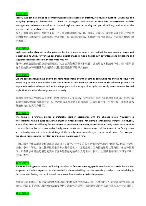
Today , a gis can be defined as a computing application capable of creating, strong, manipulating , visualizing, and analyzing geographic information. It finds its strongest applications in resources management, utilities management, telecommunications urban and regional, vehicle routing and parcel delicery, and in all of the sciences that the surface of the earth.今天,地理信息系统可以被定义为一个计算应用能够创造,强,操纵,可视化,地理信息和分析。
它发现它的强大的应用程序的资源管理,设施管理,电信城市和区域,车辆路径和包裹输送,并在所有科学的地球表面。
each geographic data set is characterized by the feature it depicts .its method for representing shape and locaton,and its utility for various geographic operations.Each modle has its own advantages and limitations and supports operations that other data types may not.每一个地理数据集的特点是特征描述。
其方法为代表的形状和位置,其效用的各种地理作业。
每个模型都有自己的优点和局限性和支持操作其他类型的数据可能不具有的。
Gis and spatial analysis have enjoy a changing relationship over the years, as computing has shifted its focus from processing to public communitication ,and exerted its influence on the ecolution of gis software.gis offers an unprecedented set of opportunities for the popularization of spatial analysis ,and ready access to complex and sophisticated routines by alarge user community.地理信息系统与空间分析有享受不断变化的关系,多年来,作为计算的重点已从处理公共通信,并对它施加影响的地理信息系统软件进化。
地理信息科学专业英语课程简介
地理信息科学专业英语课程简介Introduction to Geographic Information Science Professional English Course.1. Course Overview.In the rapidly evolving field of Geographic Information Science (GIS), the ability to communicate and understand international research, technologies, and applications is paramount. The Geographic Information Science Professional English Course aims to equip students with the linguistic skills necessary to engage effectively in the global GIS community. This course focuses on enhancing students' reading, writing, speaking, and listening skills, specifically tailored to the unique vocabulary and terminology of GIS.2. Course Objectives.To introduce students to the fundamental terminologyand concepts of GIS in an English language context.To develop students' ability to read and understand technical documents, research articles, and online resources related to GIS in English.To enhance students' writing skills, enabling them to produce clear and concise technical reports, proposals, and emails in English.To improve students' speaking and listening skills, preparing them for international conferences, collaborations, and presentations.3. Course Content.The course covers a range of topics relevant to GIS, including:Basic terminology and definitions related to GIS, such as spatial data, remote sensing, cartography, and GIS software.Technical concepts and principles of GIS, including spatial analysis, data management, and geospatial databases.Applications of GIS in various fields, such as environmental science, urban planning, transportation, and disaster management.Current trends and developments in GIS, including big data, artificial intelligence, and geospatial analytics.4. Teaching Methods.The course employs a variety of teaching methods to ensure maximum student engagement and learning outcomes:Lectures and presentations: Delivered by experienced GIS professionals, these sessions introduce students to key concepts and terminology.Interactive discussions: Students engage indiscussions to deepen their understanding of GIS conceptsand applications.Reading assignments: Students are assigned technical articles and research papers to read and analyze, cultivating their reading comprehension skills.Writing assignments: Students practice writing technical reports, proposals, and emails, receiving feedback and guidance from instructors.Role-plays and simulations: These activities simulate real-world scenarios, preparing students for international conferences and presentations.5. Course Evaluation.Evaluation of student performance is based on a combination of assessments, including:Quizzes and tests: These assessments evaluate students' knowledge and understanding of GIS terminology and concepts.Reading comprehension exercises: These exercisesassess students' ability to understand and analyzetechnical articles and research papers.Writing assignments: Students submit technical reports, proposals, and emails for evaluation by instructors.Oral presentations: Students present their work infront of their peers, demonstrating their speaking and presentation skills.6. Conclusion.The Geographic Information Science Professional English Course is an integral part of preparing students for a successful career in the global GIS industry. By acquiring the necessary linguistic skills and knowledge, studentswill be able to engage effectively with international colleagues, participate in global projects, and contributeto the advancement of GIS research and applications.。
本科专业中英文对照
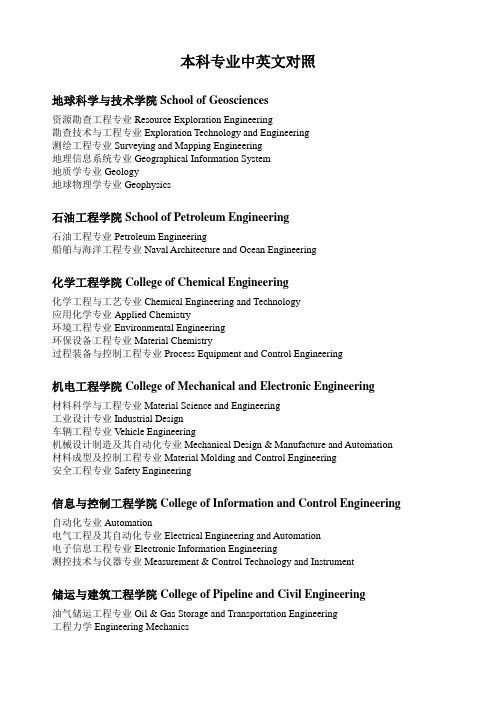
本科专业中英文对照地球科学与技术学院School of Geosciences资源勘查工程专业Resource Exploration Engineering勘查技术与工程专业Exploration Technology and Engineering测绘工程专业Surveying and Mapping Engineering地理信息系统专业Geographical Information System地质学专业Geology地球物理学专业Geophysics石油工程学院School of Petroleum Engineering石油工程专业Petroleum Engineering船舶与海洋工程专业Naval Architecture and Ocean Engineering化学工程学院College of Chemical Engineering化学工程与工艺专业Chemical Engineering and Technology应用化学专业Applied Chemistry环境工程专业Environmental Engineering环保设备工程专业Material Chemistry过程装备与控制工程专业Process Equipment and Control Engineering机电工程学院College of Mechanical and Electronic Engineering材料科学与工程专业Material Science and Engineering工业设计专业Industrial Design车辆工程专业Vehicle Engineering机械设计制造及其自动化专业Mechanical Design & Manufacture and Automation 材料成型及控制工程专业Material Molding and Control Engineering安全工程专业Safety Engineering信息与控制工程学院College of Information and Control Engineering自动化专业Automation电气工程及其自动化专业Electrical Engineering and Automation电子信息工程专业Electronic Information Engineering测控技术与仪器专业Measurement & Control Technology and Instrument储运与建筑工程学院College of Pipeline and Civil Engineering油气储运工程专业Oil & Gas Storage and Transportation Engineering工程力学Engineering Mechanics土木工程专业Civil Engineering热能与动力工程专业Thermal Power and Power Engineering建筑环境与设备工程专业Architectural Environment and Equipment Engineering建筑学专业Architecture计算机与通信工程学院College of Computer and Communication Engineering计算机科学与技术专业Computer Science and Technology软件工程专业Software Engineering通信工程专业Communication Engineering经济管理学院Schlool of Economics and Management工程管理专业Engineering Management信息管理与信息系统专业Information Management and Information System会计学专业Accounting财务管理专业Financial Management国际经济与贸易专业International Economy and Trade行政管理专业Administration Management经济学专业Economics市场营销专业Marketing and Sales公共事业管理专业Public Utility Management电子商务专业Electronic Commerce工商管理专业Business Administration理学院College of Science应用物理学专业Applied Physics材料物理专业Materials Physics材料化学专业Materials Chemistry信息与计算科学专业Information and Computing Science数学与应用数学专业Mathematics光信息科学与技术专业Optical Information Science and Technology文学院College of Arts英语专业English Language and Literature俄语专业Russian Language and Literature音乐学专业Musicology法学专业Science of Law艺术设计专业Art Design汉语言文学专业Chinese Language and Literature。
用英语介绍地理信息科学专业的作文
用英语介绍地理信息科学专业的作文Geographic Information Science (GISc) is a multidisciplinary field that combines geography, computer science, and data analysis to study and understand the world around us. This branch of knowledge explores the ways in which we collect, store, analyze, and visualize geographic data to gain valuable insights into various phenomena.At the heart of GISc lies the concept of spatial data. In simple terms, spatial data refers to any information that has a location component attached to it. This may include coordinates, addresses, zip codes, or even satellite imagery. Through the use of specialized software and analytical techniques, GISc professionals can transform this raw data into meaningful knowledge.One of the fundamental applications of GISc is in mapping and visualization. Maps have always been an essential toolfor understanding spatial relationships and patterns. With the advent of GISc, mapping has become more than just lines and colors on paper. It has evolved into a powerful tool for decision-making and problem-solving.GISc provides a unique platform for integrating various data sources. It allows researchers and professionals to combine data from different domains, such as demographics, economics, and environmental science, into a single comprehensive framework. This integration unlocks the potential for uncovering hidden patterns and relationships that can inform policy-making and planning.Moreover, GISc plays a crucial role in addressing real-world challenges. It helps in managing natural resources, predicting and mitigating natural disasters, and planning urban development. By analyzing spatial data, GISc specialists can assess the impact of human activities on theenvironment and develop sustainable solutions for a better future.In recent years, GISc has witnessed groundbreaking technological advancements. The emergence of remote sensing, GPS, and mobile mapping has revolutionized the field. These technologies enable us to collect data at an unprecedented scale and accuracy, opening doors to new discoveries and applications.To excel in the field of GISc, one must possess a rangeof skills. Proficiency in computer programming, data analysis, and spatial modeling is essential. Additionally, a deep understanding of geography, cartography, and datavisualization techniques is crucial for effectively communicating results to diverse audiences.GISc professionals find employment opportunities invarious sectors. Government agencies rely on their expertiseto develop land use policies, manage transportation networks,and assess environmental impacts. Private companies utilize GISc applications for market analysis, site selection, and logistics optimization. Non-profit organizations harness the power of GISc to support conservation efforts, disaster response, and social justice initiatives.In conclusion, Geographic Information Science is a fascinating field that merges geography with cutting-edge technology. It empowers us to unlock the potential of spatial data and gain valuable insights into the world we inhabit. By harnessing the power of GISc, we can make informed decisions and shape a better future for generations to come.。
地理信息专业英语复习资料
翻译:1、GIS is a system of hardware,software aad procedures to facilitate the manipulation,analysis,modeling,representation and display of geo—referencedcomplex problems regarding planning and management of resollrces,翻译:gis是一个由硬件、软件和程序组成的系统,便于管理、处理、分析、模拟、表现并显示地理参照数据,从而解决规划和资源管理的复杂问题。
2、GIS technology,integrates common database operations such as query and statisticalanalysis with the unique visualization and geographical analysis benefits offered by maps.Theseabilities distinguish GIS from other information systems and make it valuable to a wide range ofpublic and private enterprises for explaining events,predicting outcomes,and planning strategies(ESRI).翻译:地理信息系统技术将诸如查询和统计分析的常见的数据库操作和地图特有的可视化功能和地理分析优势集成起来。
这些功能是区分地理信息系统和其他信息系统的关键,并且对于众多的公共和私营企业用于事件解析,结果预测和战略规划十分有价值(ESEI)。
3、Projection is a fundamental component of mapmaking.A projection is a mathematicalmeans of transferring information from the earth’s three—dimensional,curved surface to a twodimensional medium--paper or a computer screen.Mathematically speaking,map projectionsare transformations of geographic coordinates(1atitude,longitude)into the Cartesian(x,y)coordinate space of the map.翻译:投影是地图制作的一个基本要素,同时也是将信息从地球的三维曲面上传递到纸张或电脑屏幕二维介质上的一种数学手段。
我的专业地理科学英语作文
我的专业地理科学英语作文英文回答:Geography is an interdisciplinary science that combines the study of physical features, human activity, and the environment. It addresses the spatial distribution of natural and human phenomena on Earth's surface and explores the relationships between them. As a broad and complex field, geography encompasses a wide range of sub-disciplines, including physical geography, human geography, environmental geography, and geospatial science.Physical geography focuses on the physical characteristics of the Earth, including its landforms, climate, water resources, and ecosystems. It investigates the processes that shape the Earth's surface and the interactions between the atmosphere, hydrosphere, and lithosphere. Human geography, on the other hand, examines the spatial patterns of human activities and their relationship with the physical environment. It exploresissues such as population distribution, migration, urbanization, and economic development.Environmental geography investigates the interactions between humans and the natural environment. It examines the impact of human activities on the environment and develops strategies for sustainable resource management. Geospatial science, also known as geographic information science (GIS), employs spatial data and analytical techniques to visualize and analyze geographic information. It is used in various fields, including land use planning, environmental modeling, and disaster management.The study of geography provides a comprehensive understanding of the Earth's systems and the complex interactions between humans and their environment. Itequips students with the analytical and problem-solvingskills necessary to address contemporary global challenges, such as climate change, urbanization, and resource scarcity.中文回答:地理科学是一门综合性学科,它结合了对自然地理、人文和环境的研究。
GIS专业英语
第一课Comprehensive:全面的,综合的,Intellectual:智力的,才智的Jargon:专业术语Terminology:专业术语Geomatique:地理信息技术Geoscience:地球科学Derivative:派生物,衍生物Cartography:地图绘制学,地图绘制Architect:建筑师Preliminary:初步的,起始的Enumerate:列举,枚举Resemble:像,与……相似Transformation:转换第二课Automated:自动化的Equivalent:a等价的Cartographer:绘制图表者,制图师Mylar:胶片Electronic:电子的Encode:编码Orthophotoquad:正射影像图Aerial:空中的,航空的Aggregation:集合,聚合,集合体Reproduction:再现,复制,繁殖Dissemination:传播,宣传,传染Counterpart:相似之物Compactness:致密性Complexity:复杂,复杂性Hamper:阻碍,束缚Retrieval:取回,恢复,修补Analog:模拟的Planimeter:测面器,求积仪Phenomena:现象Quantitative:数量的,定量的Histogram:直方图,柱状图Supplementally:追加,补充Modification:修改,变型Cartogram:统计地图,统计图Hand-drawn:手绘Emergency:紧急事件Employe:雇佣,雇工Clarify:澄清,阐明Geographic information systemGeographical information systemGeomatiqueGeorelational information systemNatural resources information systemGeoscience or geological information systemSpatial information systemSpatial data analysis systemA data input subsystem that collect andpreprocess spatial data from varioussources。
- 1、下载文档前请自行甄别文档内容的完整性,平台不提供额外的编辑、内容补充、找答案等附加服务。
- 2、"仅部分预览"的文档,不可在线预览部分如存在完整性等问题,可反馈申请退款(可完整预览的文档不适用该条件!)。
- 3、如文档侵犯您的权益,请联系客服反馈,我们会尽快为您处理(人工客服工作时间:9:00-18:30)。
专业术语英译汉affine 仿射band 波段cartography 制图学clip 剪切digitizer 数字化仪DLG 数字线划图dpi 每英寸点数edgematching 边缘匹配equator 赤道equiarea 等积geoid 大地水准面geospatial 地理空间GPS 全球定位系统Habitat 栖息地Interface 接口Item 项目Latitude 纬度legend 图例longitude 经度median 中值meridian 子午线metadata 元数据neatline 图廓线Object-Based 基于对象的parcel 宗地photogrammetry 摄影测量precipitation 降水量range 范围raster 栅格resample 重采样resolution 分辨率RMS 均方根scanner 扫描仪siting 选址TIGER 拓扑统一地理编码topology 拓扑tuple 数组UTM 通用横轴墨卡托投影vector 矢量专业术语汉译英保护区protected area比例尺Scale bar标准差Standard deviation标准图幅Standard picture frame单精度Single precision地理空间数据Geospatial data点缓冲区Point buffer动态分段Dynamic segmentation度量标准Metrics多项式变换Polynomial transformation高程基准Elevation base跟踪算法Tracking algorithm规则格网Rules grid过渡带Transition zone基于位置服务Based on location service 畸形线Malformation line几何变换Geometric transformation检验图Inspection chart解析几何Analytic geometry空间要素Space element平面坐标系统Planar coordinate system曲流河Meandering river人口普查地段Census Lot上四分位数The upper quartile矢量数据模型Vector data model数据可视化data visualization数据探查Data exploration双精度Double precision水文要素Hydrological elements泰森多边型Tyson Polygons统一建模语言Unified Modeling Language投影坐标系统Projection coordinate system 线缓冲区Line buffer遥感数据Remote sensing data用材林Timber forest晕渲法Halo rendering method指北针Compass属性表Property sheet最短路径分析Shortest path analysis最小二乘法Least squares method翻译例子如下。
1.A geographic information system (GIS) is a computer system for capturing, storing, querying, analyzing, and displaying geographically referenced data.1.地理信息系统(GIS)是用于捕捉,存储,查询,分析和显示地理参考数据的计算机系统。
2.A newly digitized map has the same measurement unit as the source map used in digitizing or scanning. If manually digitized, the map is measured in inches, same as the digitizing table.2.新数字化地图与数字化或扫描中使用的源地图具有相同的测量单位。
如果手动数字化,地图以英寸为单位进行测量,与数字化表格相同。
3.Although ideal for discrete features with well defined location and ,shapes, the vector data model does not work well with spatial phenomena that vary continuously over the space such as precipitation, elevation, and soil erosion.3.对于具有明确位置和形状的离散特征,尽管理想,矢量数据模型不能很好地处理在空间连续变化的空间现象,如降水,海拔和土壤侵蚀。
4.But the migration from the georelational to the object-based data model should be relatively easy because it is intuitive to think of spatial features as objects.4.从基础数据到基于对象的数据模型的迁移应该相对容易,因为将空间要素视为对象是直观的。
5.New GIS data can be created from a variety of data sources. They include satellite images, field data, street addresses, text files with x and y coordinates, and paper maps.5.可以从各种数据源创建新的GIS数据。
它们包括卫星图像,现场数据,街道地址,带有x和y坐标的文本文件以及纸质地图。
6.Projection converts data sets from geographic coordinates to projected coordinates, and reprojection converts from one type of projected coordinates to another type.6.投影将数据集从地理坐标转换为投影坐标,再投影从一种类型的投影坐标转换为另一种类型。
7.Spatial data editing refers to the process of adding, deleting, and modifying features in digital layers. A major part of spatial data editing is to remove digitizing errors.7.空间数据编辑是指在数字图层中添加,删除和修改特征的过程。
空间数据编辑的主要部分是删除数字化错误。
8.The georelational data model stores spatial and attribute data separately in a split system: spatial data in graphic files and attribute data in a relational database.8.地理数据模型将空间数据和属性数据分别存储在分割系统中:图形文件中的空间数据和关系数据库中的属性数据。
用英文回答下列问题,练习每章后面的问答题。
例子如下:1.Describe the two common types of data for terrain mapping and analysis.1.Two important types of field data that can be used ina GIS project are survey data and global positioningsystme (GPS) data.2.Describe three variations in buffering.2.The buffer distance can vary by the values of a given field. Buffering can be on either the left side or the right side of the line feature, instead of both sides.Buffer zones may remain intact so that each buffer zone is separate from others, or dissolved so that thereare no overlapped areas between buffer zones.3.Explain the advantages and disadvantages of the raster data model vs. the vector data model.3.The main advantage of the raster data model is having fixed cell locations, which make it easier for datamanipulation, aggregation, and analysis. The main disadvant age is its weakness in representing the precise location of spatial features.4.Explain the difference between location errors and topological errors.4.Location errors such as missing polygons or distortedlines relate to the geometric inaccuracies of spatialfeatures, whereas topological errors such as dangling lins and unclosed polygons relate to the logical inconsistencis between spatial features.5.Explain the difference between the georelational data model and the object-based data model.5.The object-based data model differs from the georelational data model in two aspects. First,the object-based data model stores both the spatial and attribute data of spatial features in a single system rather than a split system. Second, the object-based data model allows a spatial feature (object) to be associated with a set of properties and me thods.6.Explain the importance of map projection.6.A map projection offers a couple of advantages. First,a map projection allows us to use two-dimensional maps, either paper or digital, instead of a globe. Second, a map projection allows us to work with plane or projected coordinates rather than longitude and latitude values. Computations with geographic coordinates are more complex and yield less accurate distance measurements.7.How can an analysis mask save time and effort for raster data operations?7.Because an analysis mask limits data analysis to cells that do not carry the cell value of no data. it can save time and effort for raster data operations.8.Name five tools or techniques for vector data analysis.8.Buffering ,overlay , distance measurement, spatial statis tics and map manipulation .9.Name the three types of simple features used in GIS and their geometric properties.9.A point has 0 dimension and has only the property of location.A line is one-dimensional and has the property of length. And an area is two-dimensional and has the properties of area (size) and perimeter.10.Name two examples each for integer rasters and floating-point rasters.10.Examples of integer rasters are land use and soiltypes. Examples of floating-point rasters are precipitation and elevation.11.The georelational data model uses a split system to store vector data. What does a split system mean?11.A split system stores spatial data in graphic filesand attribute data in a relational database. Typically, a georelational data model uses the feature label or ID to link the two components.12.The output from a viewshed analysis is a binary map. What does a binary map mean in this case?12.The output from a viewshed analysis is a binary map, which showing visible and not visible areas from the viewpoint.13.What are the basic elements of the raster data model?13.The basic elements of the raster data model are cell value, cell size, raster bands, and spatial reference14.What are the common elements on a map for presentation?14.The common elements on a map for presentation include the title, body, legend, north arrow, scale, acknowledgment, and neatline/map border.15.What is a feature attribute table?15.A feature attribute table is a table associated witha vector data set, which has access to the data set’s spatial data.16.Why is the datum important in GIS?16.A datum is important in GIS because it serves as thereference or base for calculating the geographiccoordinates of a location.。
