福州大学紫金矿业学院2009级资源勘查工程专业英语复习题(完整版)
工程地质勘察技术测试题(含答案)

工程地质勘察技术测试题(含答案)一、单项选择题(每题2分,共20分)1. 工程地质勘察的主要目的是()。
A. 了解地质环境B. 获取地质资料C. 分析地质问题D. 评价地质条件答案:D2. 下列哪项不是工程地质勘察的方法()。
A. 钻探B. 物探C. 室内试验D. 实地调查答案:D3. 在工程地质勘察中,钻探主要用于()。
A. 获取地质资料B. 分析地质问题C. 评价地质条件D. 了解地质环境答案:A4. 下列哪种地质勘察方法属于无损勘察()。
A. 钻探B. 物探C. 室内试验D. 实地调查答案:B5. 工程地质勘察报告的主要内容包括()。
A. 勘察目的、任务和要求B. 勘察方法、程序和过程C. 勘察成果和结论D. 勘察费用和工期答案:C二、多项选择题(每题3分,共15分)6. 工程地质勘察的主要任务包括()。
A. 了解地质环境B. 获取地质资料C. 分析地质问题D. 评价地质条件E. 提供设计依据答案:ABCDE7. 工程地质勘察方法可分为()。
A. 地质测绘B. 钻探C. 物探D. 室内试验E. 实地调查答案:BCDE三、判断题(每题3分,共15分)8. 工程地质勘察仅需在项目初期进行一次,无需在项目实施过程中进行调整。
()答案:×9. 工程地质勘察报告只需提供地质条件评价,无需提供设计建议。
()答案:×10. 工程地质勘察中,物探方法对人体和环境具有危害。
()答案:×四、简答题(每题10分,共30分)11. 请简述工程地质勘察的主要任务。
答案:工程地质勘察的主要任务包括了解地质环境、获取地质资料、分析地质问题、评价地质条件、提供设计依据和施工指导。
12. 请简述工程地质勘察的方法。
答案:工程地质勘察的方法包括地质测绘、钻探、物探、室内试验和实地调查。
13. 请简述工程地质勘察报告的主要内容。
答案:工程地质勘察报告的主要内容包括勘察目的、任务和要求,勘察方法、程序和过程,勘察成果和结论,勘察费用和工期。
土木工程地质复习题双语

土木工程地质(双语)复习题一.填空1.Engineering geology is about applying all branches of thegeosciences to assure the (safety),( efficiency), and (economy of engineering )and( environ mental projects.)2.Physical properties of minerals include:( Crystal form)、( Hardness)、(color)、( Luster)、(Streak )、( cleavage)。
3.The classification of rock according to the cause offormation are (igneous rock)、(sedimentary rock)、(metamorphic rock)。
4.The physical properties of groundwater(temperature)、(color)、(taste)、(transparent)、(smell)、(radioactivity)5.Geological environment (geological condition) :(the studyabout topography and landforms)、(the study about the fundamental engineering )、( properties of soils)、( rock)、(geological structure)、(hydrogeology)。
6.relative dating methods:(strata superposition method)、(fossil succession method)、(the method of rock layers contact relation)。
资源勘查工程专业外语
专业外语复习题英译汉、汉译英:1)abnormal high formation pressure 异常高地层压力2)reservoir drive 油藏驱动3)hydrostatic pressure gradient 静水压力梯度4)geothermal gradient 地温梯度5)dolomitization 白云岩化作用6)rollover anticline 滚动背斜7)unconformity trap 不整合圈闭8)faulting trap 断层圈闭9)salt plug 盐丘10)the use of well logging 测井应用11)stratigraphic trap 地层圈闭12)Permian sandstone reservoir 二叠系砂岩储层13)the late petroleum generation hypothesis晚期石油生成说14)organic-rich shale 富含有机质页岩15)buoyancy 浮力16)clastic or detrial rock 碎屑岩17)the strike contours 等值高线18)transgressive sequence 水进层序19)desgressive sequence 水退层序20)sequence stratigraphy 层序地层学21)well-sorted sands 分选好的砂22)secondary growth of quartz 石英次生加大23)the capacity of a fault 断层封闭24)growth fault 同生(生长)断层25)fluvial facies 河流相26)Carboniferous limestone石炭化石灰岩27)Cretaceous dolomite 白垩纪白云岩28)fan-delta 扇三角洲29)insoluble organic matter30)a potential source rock 潜在烃源岩31)evolutionary stages of kerogen 干酪根的演化阶段32)secondary pores 次生孔隙33)petroleum migration 石油运移34)hydrocarbon accumulation 烃类聚集35)kerogen 干酪根36)porosity 孔隙度37)permeability 渗透率38)water-saturation 含水饱和度39)hydrodynamic condition 水动力条件40)oils and source rocks correlation 油源岩对比41)effective porosity 有效孔隙度42)types of reservoir drives 油藏驱动类型43)lens of sandstones 砂岩透镜体44)sedimentary facies 沉积相45)minor structure 微幅构造46)subsidence or depression belt 沉陷带47)nose structure 鼻状构造48)reservoir heterogeneity 储集层非均质性49)high point of structure 构造高点50)oil-field water 油田水51)original reservoir pressure 原始储层压力52)salinity 盐度(矿化度)53)anticline 背斜54)syncline 向斜55)normal fault 正断层56)reverse fault 逆断层57)geological mapping 地质制图58)organic matter 有机质59)residual oil 剩余油60)primary pore 原生孔隙secondary pore次生孔隙61)coarse-sandstone 粗砂岩62)fine-sandstone 细砂岩63)silt stone 粉砂岩64)mature stage of hydrocarbon source rock烃源岩成熟阶段65)structural strike contours 构造等值线66)absolute permeability 绝对渗透率67)arkoses 长石砂岩68)elaborate geological description of oil pools油藏精细地质描述名词解释:1、Fossils:are the recognizable remains or traces of animals and plants that were preserved insediments,rocks and other materials.2、Minerals: A naturally occuring substance with a fairly definite chemical composition and characteristic physical properties by which it may be identified.3、Karst limestone: in the warm and humid weather ,a highly dissolved limestone.4、Faults: are breaks in the rocks in which one side has moved relative to the other.5、Reservoir rocks: some subsurface rocks ,which have voids or spaces and can hold fluids.6、Unconformity: a break in the sequence of local geologic deposition ,marked by an erosion surface,above and below which the beds are of different ages.7、Fold: reformation of the bed which is thrown into a series of ridges and valley by squeez and tension.8、Porosity:is a percentage of holes or voids in the rock and controls how much fluids the rock can hold.9、Permeability:is a measure of the ease with which a fluid can flow through the rock.同义词:地下underground = subsurface构造圈闭tectonic trap = structural trap背斜anticline = upford 向斜syncline = downfold 单斜monocline = homocline假整合disconformity = 平行不整合parallel unconformity地层bed =layer = formation = stratum逆断层reversed fault = thrust 逆掩断层overthrust节理、裂缝crack = fissure = fracture = joint粒间的interparticle = intergranular原生孔隙primary pores = initial pores油藏pools = deposits of oil and gas地堑trough fault = graben 地垒ridge fault = horst尖灭buttress = wedge out碎屑岩clastic = detrial = fragmentary + rock孔隙pore = void油藏oil reservoir = oil pool = oil deposit岩性圈闭lithologic trap = depositional trap露头outcrop = exposing = cropping out翻译:The actural pores may have had a complex history.A skeletal element, for example , may be removed by solution,leaving a mold , which may be enlarged by further solution and converted to an irregular vug. Either the mold or the enlarged product may be partially to completely filled at any stage . The history of pore filling , whatever the origin of the pore , is complex.实际空隙可能有复杂的历史,。
矿产勘查学习题参考资料

矿产勘查学习题第一、二章一、填空:1 ()是矿产预查、矿产普查、矿产详查与矿产勘探的总称。
2 ()是矿查区是否进行详查工作的依据。
3 ()是矿查区是否进行勘探工作的依据。
4 ()是矿山建设设计和矿山开采设计的依据。
5 勘查范围的()与矿床产出空间的()及矿床特征的()是矿产勘查的主要矛盾。
6 地质特征可分为()和()7 矿产普查通常分为()和()8 矿产勘查的工作主要内容包括()和()9()是选择勘查目标和确定勘查范围的基本依据10()是在当前技术经济条件下和矿产品市场条件下能满足国民经济要求并取得经济效益的矿体。
11最优勘查方案的确定所用的方法可以分为()和()两大类。
二、判断:1 矿产勘查即矿产勘探。
()2 目前我国的矿产资源基本能够自给。
()3 矿产勘查的目的在于发现、探明矿产资源。
()4 矿产详查是矿产勘查的最后阶段()5 矿产勘查设计的编制与审批是勘查项目管理全过程中的首要环节。
()6 矿产勘查和找矿的含义是相同的()7 矿产勘查的核心是预测()8 查明矿床地质特征和矿体地质特征是矿床勘查的首要任务()9 成矿地质条件是制约矿产勘查难易程度和精度的基础()10 各种地质作用、地质过程和地质现象都不一定具有的数量规律性()11 矿化具有天然密度等级特点()12 矿体的属性特征受工业要求和市场价格的制约()13 矿产勘查是一项科研活动,而不是一种经济活动()14 在正确选择工作技术手段和程序的前提下,地质勘查结果是确定的()三、单选:1 了解研究区矿产资源远景,圈出矿化潜力较大的地段是矿产勘查哪个阶段的工作内容()a 矿产预查b 矿产普查c 矿产详查d 矿产勘探2 查明区内地质情况,大致掌握矿体特征属于矿产勘查哪个阶段的工作内容()a 矿产预查b 矿产普查c 矿产详查d 矿产勘探3 基本查明矿体形态和质量特征,评价矿体是否有开采价值属于矿产勘查哪个阶段的工作内容()a 矿产预查b 矿产普查c 矿产详查d 矿产勘探4 矿床特征不包括以下那个部分()a 矿体特征b 矿石物质组成c 成矿地质条件d 矿石质量5 矿石质量研究包括()a 矿物组成以及主要矿物含量b 矿石自然类型和工业品级c 结构d 构造四、多选:1 以下名词与“矿产勘查”同义的有()a 地质调查b 矿产资源勘查c 地质勘查d 矿产地质勘查2 矿产勘查工作的阶段包括()a 预查阶段b 普查阶段c 详查阶段d 勘探阶段3 矿产勘查工作应遵循的基本原则有()a 因地制宜原则b 最经济原则c 循序渐进原则d 综合评价原则4 矿产勘查的理论基础有()a 地质基础b 数学基础c 经济基础d 技术基础5 矿产勘查的最优化准则是()a 最优地质效果与经济效果的统一b 最高精度要求与最大可靠程度的统一c 模型类比与因地制宜的统一 d 随机抽样与重点观测的统一 e 全面勘查与循序渐进的统一6 科学找矿是指()a 理论找矿b 综合找矿c 立体找矿d 定量找矿7 工业矿体的工业指标包括()a 边界品位b 最低工业品位c 最低可采厚度d 矿体产状第三章:一、填空:1 重砂测量的主要研究对象是各种疏松沉积物中的()。
矿产勘查学总复习提纲—含两份试题.doc
第一章绪论1.矿产勘查:在区调基础上,根据国民经济和社会发展的需要,运用地质科学理论,使用多种勘查技术手段和方法对矿床地质和矿产资源所进行的系统调查研究工作。
2.矿产勘查学:研宄矿产形成与分布的地质条件、矿床赋存规律、矿体变化特征和研宄工业矿床最有效的理论与方法。
研究内容:矿产预测、矿产勘查、矿产评价。
研究对象:工业矿体基本任务:研究矿体形成条件、赋存规律及矿体变化性特征,并在此基础上,研究合理有效地预测、勘查和评价矿床的理论和方法3.矿产勘查学的研究方法:地质观察研究法、勘查统计分析法、勘查模型类比法、技术经济评价法4.矿产勘查的基本原则:1.因地制宜:最基本最重要的原则2.循序渐进:由粗到细、由表及里、由浅入深、由己知到未知3.全面研宄;4.综合评价;5.经济合理5.矿产勘查阶段划分为:预查、普查、详查、勘探目的与意义:减少勘查投资风险,确保后续勘查合理性,提高矿产勘查效益5.矿产资源:由地质作用形成于地壳闪或地表的自然富集物,并在当前经济技术条件下具有经济意义的物质根裾地质可靠程度分为:査明矿产资源、潜在矿产资源6.矿产资源储量分类依据:1.地质可靠程度:预测的4、推断的3、控制的2、探明的12.可行性评价:概略研究3、预可行性研宄2、可行性研究13.经济意义:经济的1、边际经济的2M、次边际经济的2S、内蕴经济的3、经济意义未定的7.储量:扣除了设计、采矿损失的基础储量中经济可采部分基础储量(b):查明矿产资源的一部分,未扣除设计、采矿损失。
第二章矿床类型1.矿床勘查类型:按矿床主要地质特点及勘查难易程度,将特点相似的矿床加以理论综合与概拈划分的类型。
划分目的:总结实践经验,指导实际工作,为合理选择勘查手段、勘查程度、工程部署提供依据划分依裾:矿体规模、主矿体形态变化程度、主矿体厚度的稳定性、受构造和脉岩影响程度、矿体屮主要有用组分的分布均匀程度。
2.矿床勘查类型确定原则:1.追求最佳勘查效益原则;2.从实际岀发原则;3.以主矿体为主原则;4.类型三分,允许过渡原则;5.在实践屮验证并及时修正原则第三章矿产勘查技术方法1.矿产勘查技术方法根据原理可分为:1.地质测量法:小比例尺地质测量(1: W0万〜50万);屮比例尺地质测量(1: 20万〜5万);大比例尺地质测量(1: 1万以上)2.重砂测量法:水系法、水域法、测网法3.地球化学方法:岩石测量法、土壤测量法、水系沉积物测量法、水化学测量法、生物测量法4.地球物理方法:与围岩有明显物性差别;有一定体积。
高二英语地质勘探单选题40题
高二英语地质勘探单选题40题1.Geologists use a variety of tools for exploration. One of the essential tools is a _____.passB.hammerC.satelliteD.microscope答案:B。
hammer(锤子)是地质学家进行地质勘探时常用的工具之一,可以用来敲碎岩石进行观察。
compass( 指南针)主要用于确定方向,在地质勘探中不是最主要的工具。
satellite( 卫星)通常用于大范围的地理信息获取,不是直接用于地质勘探的工具。
microscope 显微镜)一般用于微观观察,在地质勘探现场不是主要工具。
2.In geological exploration, a _____ is often used to measure the thickness of rock layers.A.rulerB.tape measureC.sonar deviceD.protractor答案:B。
tape measure( 卷尺)可以用来测量岩石层的厚度。
ruler 尺子)一般较短,不太适合测量较厚的岩石层。
sonar device(声呐设备)主要用于水下探测,与测量岩石层厚度关系不大。
protractor( 量角器)主要用于测量角度。
3.When studying the structure of the earth, geologists often rely on a _____.A.televisionputerC.telescopeD.ground-penetrating radar答案:D。
ground-penetrating radar 探地雷达)可以帮助地质学家研究地球的结构。
television(电视)主要用于娱乐和信息传播,与地质勘探无关。
computer(电脑)可以用于数据处理,但不是直接用于研究地球结构的工具。
资源勘查考试复习资料

1、矿区实际材料图上应包括哪些内容?①所有地质、①所有地质、水文地质观察路线、水文地质观察路线、水文地质观察路线、观察点及编号②全部勘查线、观察点及编号②全部勘查线、观察点及编号②全部勘查线、探矿工程及编号③各类探矿工程及编号③各类样品和标本的采集位置④见矿及未见矿的钻孔、老硐、老坑、采场、产状等⑤主要地质界线及地层代号、工作范围及基线侧线位置及编号 2、如何编制勘查线剖面图?①在图纸上绘制坐标线。
一般选择剖面线与坐标线交角大于4545°的一组,并标在图上。
°的一组,并标在图上。
②地表地形线的绘制。
以坐标线为基线将地形的转换点绘到剖面上,以坐标线为基线将地形的转换点绘到剖面上,用圆滑线将这些点用圆滑线将这些点连接起来。
③勘查工程的绘制。
以坐标线为基线,根据测量成果将探槽、浅井、钻孔等绘在剖面图上。
绘在剖面图上。
④地质界线的绘制。
④地质界线的绘制。
④地质界线的绘制。
依据各种勘查原始编录资料,依据各种勘查原始编录资料,依据各种勘查原始编录资料,将各种地质界线点按将各种地质界线点按比例尺绘到相应的位置上,且注明其产状、取样位置和编号。
⑤在综合分析、研究、推断的基础上,断的基础上,依其空间位置相互关系、依其空间位置相互关系、依其空间位置相互关系、产状和地质规律连接工程间岩层界线、产状和地质规律连接工程间岩层界线、产状和地质规律连接工程间岩层界线、矿体界线矿体界线和断层等构造线。
和断层等构造线。
⑥如用来估算资源储量时,⑥如用来估算资源储量时,应画出各矿石类型和资源量级别界线,应画出各矿石类型和资源量级别界线,应画出各矿石类型和资源量级别界线,并注明面积号、并注明面积号、并注明面积号、面积面积数、资源储量级别。
⑦用投影法在图下边绘出勘查线平面草图,其一侧放分析结果表,最后完善图名、比例尺、图例、图签。
⑧编制砂矿勘查线剖面图,为满足不同开采方法的需要,应按不同的工业指标,圈出不同开采方法的开采界线。
矿产资源勘查学期末考试试卷(A卷+答案)

成都理工大学2006—2007学年 第二学期《矿产资源勘查学》期末考试试卷(A 卷)一、填空题(20分,每空1分) 1、固体矿产勘查工作分为预查、 普查 、 详查、 勘探 4个阶段。
划分勘查阶段是为了避免在地质依据不足或任务不明的情况下进行盲目开发所造成的重大损失,是遵循“循序渐进、由已知到未知、由浅部到深部”的技术原则。
2、矿产勘查的特点就是在不确定条件下进行各种决策,其基本理论基础包括地质基础、 数学基础、 经济基础及 技术基础四个基本方面。
3、根据1999年新的《固体矿产资源/储量分类》国家标准,矿产勘查可行性评价据其目的、任务可分为概略研究、 预可行性研究 和 可行性研究 三个阶段。
4、找矿标志按照其成因分类可分为 地质标志、 地球化学标志、 地球物理标志、 生物标志 和人工标志五类;按其与矿化的联系可分为直接找矿标志和间接找矿标志两类。
5、矿产勘查中常用的采样方法主要有打块法、刻槽法、岩心采样、岩屑采样、 剥层法采样和全巷法。
二、名词解释(20分,5×4) 1、成矿规律:矿床在空间上和时间上与各种地质特征的关系。
2、成矿模式:成矿模式是对矿床赋存的地质环境、矿化作用、随时间变化显示的各类特征和成矿物质来源、迁移富集机理等矿床成因要素进行的概括、描述和解释,是某类矿床共性的表达方式。
3、地质编录:在找矿工作中,通过对工程揭露的各种地质现象,采样分析鉴定的成果及综合研究成果,直观地,正确地,系统地用文字、图片表示、秒回下来,这些工作就叫地质编录。
4、矿产工业指标:是在当前的技术经济条件下,工业部门对矿产质量的开采条件所提出的标准要求,也就是评定矿床工业价值、圈定工业矿体和估算工业矿产资源储量所遵循的标准。
5、地质调查:指一切以地质现象(岩石、地层、构造、矿产、水文地质、地貌等)为对象,以地质学及其相关科学为指导,以观察研究为基础的调查工作。
三、简答题(30分,3×10)1、依据地质可靠程度和可行性评价所获得的不同结果可将查明矿产资源分为储量、基础储量和资源量。
矿产勘查复习资料及答案

绪论1、矿产勘查的概念矿产勘查:是在区域地质调查的基础上,据国民经济和社会发展的需求,运用地质科学理论,使用多种地质勘探理论和方法,对矿床地质进行的系统调查研究工作。
2、矿产勘查的任务和意义基本任务是:根据国民经济和社会发展的需要及地质条件的可能,寻找和查明具有经济价值的工业矿床,为国民经济建设提供矿产资源依据,为矿山企业建设提供矿物原料基地和矿产储量。
矿产勘查的意义主要取决于它在国民经济中的地位和作用两个方面。
1)在国民经济中的地位:矿产勘查工作是对地质、矿产资源进行的调查研究工作,目的在于发现、探明矿产资源,保证国民经济建设和社会发展的基本需求。
2)在国民经济中的作用:矿产勘查所服务的方向及涉及的内容极为广泛,它既为基础产业服务又为基础建设服务,既为矿业、农业、工业也为高技术产业服务,它是基础产业的基础,也是基础设施建设的先行。
3、矿产勘查的基本原则1)因地制宜原则2)循序渐进原则3)全面研究原则4)综台评价原则5)经济合理原则4、矿产勘查的基本程序立项论证、设计编审、组织实施和报告编审5、矿产勘查的研究方法研究方法主要是:1、地质观察研究2、勘查统计分析法3、勘查模型类比法4、技术经济评价法第一章矿产勘查的理论基础1、矿产勘查的理论基础?矿产勘查的地质基础包括哪些内容?矿产勘查的理论基础: 地质基础数学基础经济基础技术基础1、矿产与地质背景的关联性包括:1)裂谷环境2)海构环境3)岛弧环境4)大陆边缘海环境5)地缝合线型成矿环境6)板块内部环境2、矿产的共生性包括:1)矿种共生2)矿床类型共生3、矿产的分带性包括:1)全球分带2)区域分带3)矿区分带4、矿产分布的不均匀性包括:1)矿产时间分布的不均匀性2)矿产空间分布的不均匀性5、矿化的不均一性2、什么是结构水平?矿化的不均一性,可以在不同的规模上表现出来,称为结构水平。
第二章矿产勘查程序和阶段划分1、与矿山建设程序相适应,矿产勘查一般划分为那几个阶段?矿产勘查分为资源勘查与开发勘探两大阶段。
桂林理工大学矿产勘查复习题(全)绝版

桂林理工大学矿产勘查复习题(全)绝版一、名词解释1.矿产勘查:在区域勘查的基础上,根据国民经济和社会发展的需要,运用地质科学理论和各种勘查技术手段和方法,对矿床地质和矿产资源进行系统勘查。
2、矿产勘查学:以地质科学为基础,以地质观察研究为基本方法,以各种工程技术方法为手段,以提高矿产勘查的地质经济效果和社会效益为目的的应用地质学。
3.储量:基本储量中扣除设计和开采损失后的经济可采部分。
4.基本储量:未扣除设计和开采损失的已查明矿产资源的一部分。
5.332资源:在详细调查部分,进行了一般性研究,以达到控制程度。
经济意义是经济边际经济资源的一部分。
矿床勘查类型:按矿床主要地质特点及勘查难易程度,将特点相似的矿床加以理论综合与概括划分的类型。
一、名词解释1.地质调查方法:根据地质观测研究,在相应平面或剖面上客观反映区域成矿区内的各种地质现象。
2.重砂测量法:以各种松散沉积物中自然重砂矿物为主要研究对象,以解决与重砂有关的地质与找矿问题为主内容,采取重砂寻找砂矿和原生矿的一种地质找矿方法。
3.横切:在垂直于含矿岩系走向的表面上没有直接出口的水平隧道,通常用于连接竖井和矿脉。
1、名词释义矿产预测:在成矿地质理论的指导下,总结矿床成矿模式和找矿模式,建立矿产预测准则,对预测区潜在矿产资源进行预测工作,圈定成矿远景区和优选成矿靶区,并提出进一步找矿的部署意见。
相似类比理论:相似的地质环境和成矿条件可以形成相似的矿床。
高度概括的成矿规律可应用于相似地区,指导相似矿物的成矿预测。
成矿规律:指对矿床形成和分布的时间、空间、物质来源及共生关系诸方面的高度概括和总结。
矿床时间分布规律、矿床空间分布规律、成矿物质来源规律、矿床共生规律一、名词解释1.矿体地质学:以矿体为研究对象,其基本任务是研究矿体各种标志物的变异性。
目的是阐明矿体各标志点的变化特征或规律,为选择合理的勘查方法和矿床工业评价提供依据。
2、矿体变化性质:矿体形态、产状、品位、品级等标志在矿体不同空间位z上相互之间的联系与变化规律。
2011年福州大学学生手册考试试卷+答案
22、1958年;1993年
23、艰苦奋斗;严谨求实;团结拼搏;开拓创新
24、2
二、计算题(第一题5分,第二题20分)
1、该门课程学分为80÷16=5······················1分
14、学生违反学校关于学生宿舍管理的有关规定,扰乱宿舍管理秩序者,视其情节轻重,给予下列处分:①未经批准,随便调换、私自占用学生宿舍或出租床位,经批评教育不改者,给予____________处分;②未经批准,擅自留宿非本宿舍成员,经批评教育不改者,给予____________处分。留宿异性或在异性宿舍内住宿的,视情节给予____________处分;对本宿舍同学留宿异性不制止不报告者,给予____________处分;③扰乱宿舍管理秩序,影响他人正常学习生活,经批评教育不改者,给予____________处分;④宿舍内不得储藏或使用易燃、易爆、有毒和强腐蚀性物品,不得使用明火、不得使用或保管违规用电器,不得私拉电线、盗用公共用电,违者给予____________处分;⑤在学生宿舍内饲养宠物,经劝阻无效者,给予____________处分。
14、警告以上;警告;记过以上;警告;警告以上;警告以上;警告
15、警告;严重警告;记过;留校察看;旷课1学时
16、一年;开除学籍
17、≥2.5;≥2.0
18、5%以内;10%以内;20%以内
19、怡山校区;旗山校区;铜盘校区;鼓浪屿校区;集美校区
20、1958;以工为主、理工结合;21;阳光学院;至诚学院
2011年福州大学学生手册考试试卷
学院专业班姓名学号成绩
一、填空(每空0.5分,共50分)
中国地质大学智慧树知到“资源勘查工程”《地球科学概论》网课测试题答案4

中国地质大学智慧树知到“资源勘查工程”《地球科学概论》网课测试题答案(图片大小可自由调整)第1卷一.综合考核(共15题)1.三角洲沉积在河流的()A.上游B.中游C.下游D.出口处2.1968年勒皮雄将全球岩石圈划分为欧亚板块、印度洋板块、南极洲板块、()、()和()六大板块。
A.非洲板块B.太平洋板块C.美洲板块D.北极板块3.岩溶漏斗的形成是由于()A.地下水的水平运动B.地下水的垂直运动C.地表流水D.地下暗河的流动4.河漫滩在剖面上具有二元结构。
()A.正确B.错误5.岩浆侵入到石灰岩中,在接触带上使石灰岩变成大理岩,造成这种现象的地质作用类型为()A.岩浆作用B.接触变质作用C.动力变质作用D.侵入作用6.越是靠近洋中脊的地区,沉积物厚度越大。
() A.正确B.错误7.以下属于有色金属矿产的是()A.铁B.铜C.铅D.锌8.形成砾岩的成岩作用方式最有可能的是()A.压实作用和胶结作用B.重结晶作用和分异作用C.重结晶作用和交代作用D.变质结晶作用和岩浆作用9.室内实习时,某同学对倾斜地层地质构造模型在其某剖面上描述正确的是()A.横剖面,自下而上中等倾斜并依次发育O,S,D,C地层,地层线平行且水平B.纵剖面,自下而上依次发育O,S,D,C地层,地层线倾斜且平直C.横剖面,自下而上中等倾斜并依次发育O,S,D,C地层,地层线平行且平直D.纵剖面,自下而上依次发育O,S,C地层,地层线倾斜且平行10.潮湿气候区可形成锰,铝沉积,碳酸钙仅沉积于干旱气候区的湖泊中。
()A.正确B.错误11.古登堡面是()和()的分界面A.地幔B.地壳C.地核D.地心12.在地壳中,按克拉克值由大到小的顺序排列的四种元素是()A.Fe-O-Si-AlB.O-Si-Fe-AlC.Si-O-Al-FeD.O-Si-Al-Fe13.下列描述正确的是()A.虎峪实习区的地壳新构造或现代构造运动的特征主要以阶段性抬升为主B.通常,细粒的基性侵入岩抗风化能力较细粒的石英砂岩强C.石林,落水洞,溶蚀漏斗主要是由包气带水的剥蚀作用形成的D.北半球中纬度陆地上,自北向南流动的低空大气通常形成顺时针旋转的气旋14.在某喀斯特旅游景点,由上到下观察到6层溶洞,其中最下一层发育地下暗河。
福州大学紫金矿业学院资源勘查工程专业英语复习题(精简版)
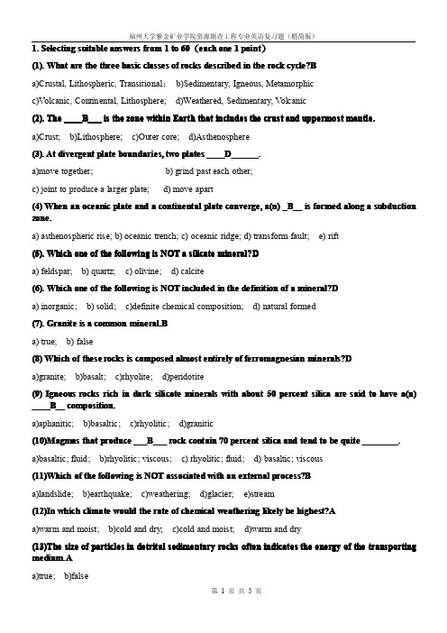
1.Selecting suitable answers from1to60(each one1point)cycle?B B(1).What are the three basic classes of rocks described in the rock cycle?a)Crustal,Lithospheric,Transitional;b)Sedimentary,Igneous,Metamorphicc)Volcanic,Continental,Lithosphere;d)Weathered,Sedimentary,Volcanic____B B___is the zone within Earth that includes the crust and uppermost mantle.(2).The____a)Crust;b)Lithosphere;c)Outer core;d)Asthenosphere____D D______.(3).At divergent plate boundaries,two plates____a)move together;b)grind past each other;c)joint to produce a larger plate;d)move apart(4)When an oceanic plate and a continental plate converge,a(n)_B__is formed along a subduction zone.a)asthenospheric rise;b)oceanic trench;c)oceanic ridge;d)transform fault;e)riftmineral?D D(5).Which one of the following is NOT a silicate mineral?a)feldspar;b)quartz;c)olivine;d)calcitemineral?D D(6).Which one of the following is NOT included in the definition of a mineral?a)inorganic;b)solid;c)definite chemical composition;d)natural formed(7).Granite is a common mineral.mineral.B Ba)true;b)falseminerals?D D(8)Which of these rocks is composed almost entirely of ferromagnesian minerals?a)granite;b)basalt;c)rhyolite;d)peridotite(9)Igneous rocks rich in dark silicate minerals with about50percent silica are said to have a(n) ____B B__composition.____a)aphanitic;b)basaltic;c)rhyolitic;d)granitic___B B___rock contain70percent silica and tend to be quite________.(10)Magmas that produce___a)basaltic;fluid;b)rhyolitic;viscous;c)rhyolitic;fluid;d)basaltic;viscousprocess?B B(11)Which of the following is NOT associated with an external process?a)landslide;b)earthquake;c)weathering;d)glacier;e)streamhighest?A A(12)In which climate would the rate of chemical weathering likely be highest?a)warm and moist;b)cold and dry;c)cold and moist;d)warm and dry(13)The size of particles in detrital sedimentary rocks often indicates the energy of the transporting medium.medium.A Aa)true;b)false(14)Sedimentary rocks form when the products of _D ___are transported to a new location where they are deposited and eventually _________into solid rock.a)melting;crystallized;b)deposition;eroded;c)tectonism;weathering;d)weathering;lithified(15)Which one of the following is NOT a sedimentary structure or feature that helps geologistsinterpret past geological conditions?conditions?A A a)vesicles;b)mud cracks;c)particle sorting;d)ripple marks;e)cross-bedding(16)The common name for sediment consisting of particles between 1/16mm and 2mm is ____D D __.a)clay;b)silt;c)gravel ;d)sand(17)A metamorphic rock's texture and composition reflect the degree of metamorphism it hasundergone.undergone.A A a)true;b)false(18)What is the major source of heat for contact metamorphism?metamorphism?D D a)deep burial;b)frictional heat created by moving faults;c)heat from the decomposition of minerals;d)heat from a nearby magma body(19)Which one of the following is NOT a type of Unconformity?Unconformity?C C a)nonconformity;b)disconformity;c)transitional unconformity;d)angular unconformity;(20)Which of these faults may displace older strata over younger strata?strata?C C a)strike-slip faults;b)normal faults;c)thrust fault;d)transform fault;(21)On a geologic map,measurements called (trend)and (inclination)are usedto describe the orientation or attitude of a rock layer or fault surface.a)strike;dip;b)alignment;slope;c)direction;tilt;d)bearing;incline;(22)Most jo joi i nts form at depths where rock is ductile.ductile.B B a)true;b)false;(23)When we observe strata that are inclined at a steep angle,we can conclude that they were tiltedsometime after their deposition by a pp pplying lying this relative dating principle.principle.C C a)superposition;b)cross-cutting;c)original horizontality;d)inclusion;(24)Which one of the following is NOT associated with crustal deformation?deformation?D D a)joints;b)folds;c)faults;d)cross-bedding;(25)Only shallow focus earthquakes are detected in this setting.setting.B B a)the asthenosphere;b)oceanic ridges;c)subduction zones;d)convergent plate boundaries;(26)Which seismic waves travel the fastest?fastest?A Aa)P waves;b)S waves;c)surface waves;d)sonic waves;(27)The source of an earthquake is called the.a)epicenter;b)seismic center;c)focus;d)inertia;past.B B(28)Pangaea was the most recent but not only supercontinent to exist in the geologic past.a)true;b)false;(29)New Lithosphere is added nearly equally to two diverging plates causing the ocean floor tosymmetrically.A Agrow symmetrically.a)true;b)false;(30)Which of these bodies of water provides scientists with a view of how the Atlantic Ocean mayinfancy?B Bhave looked its infancy?a)Gulf of Mexico;b)Red Sea;c)Caspian Sea;d)Black Sea;(31)Continental rifting occurs in regions that are being acted upon mainly by.a)compressional forces;b)shear forces;c)extensional forces;d)radial forces;(32)Geologists refer to an accreted crustal block that has a geologic history distinct from the adjoining region as a.a)terrane;b)outlier;c)anomaly;d)accretionary wedge;(33)As Ice sheets get larger,sea level.a)rises;b)drops;c)remains unchanged;d)fluctuates widely;shields.B B(34)Mountain belt are one part or subdivision of region called shields.a)true;b)false;(35)Materials deposited by turbidity currents contribute to the formation of.a)deep-sea fans;b)alluvial fans;c)floodplains;d)beaches;Earth?B B(36)Which one of the following is NOT a principle division of the solid Earth?a)crust;b)troposphere;c)out core;d)mantle;(37)Convergent plate mamar r g i ns occur where two plats are moving toward one an ano o ther and theby:D Dmovement is accommodated by:a)Earth getting larger;b)one plate sliding horizontally past the other;c)new material being added at transform fault boundaries;d)one plate descending beneath the other;(38)The region where oceanic Lithosphere descends into the asthenosphere is called.a)an accretionary wedge;b)a hot spot;c)a subduction zone;d)a mantle plume;the:C C(39)Earths rigid outer layer overlies a zone of weaker and hotter material known as the:a)cryosphere;b)lithosphere;c)asthenosphere;d)mesosphere(40)Along the San Andreas Fault,the Pacific plate is moving toward the northwest,relative to theplate.A ANorth American plate.a)true;b)false;(41)The most common group of rock-forming minerals is the.a)oxides;b)silicates;c)carbonates;d)sulfideselements?C C(42)All silicate minerals contain which of the following two elements?a)iron,magnesium;b)iron,silicon;c)silicon,oxygen;d)magnesium,silicon(43)The granite has a(n)texture.a)phaneritic;b)aphanitic;c)porphyritic;d)glassy(44)Which one of the following is NOT a primary factor of magma that directly determines theuption?D Dnature of a volcanic e r uption?a)temperature;b)amount of dissolved gases;c)composition;d)volumegranite?B B(45)Which one of the following is NOT a product of the chemical weathering of granite?a)clay;b)sulfur dioxide;c)potassium ions;d)silica in solution(46)Which list of silicate minerals shows the order in which they would weather from least resistantresistant?C Cto most resistant?a)quartz,olivine,potassium feldspar,amphibole;b),amphibole olivine,quartz potassium feldspar; c),olivine,amphibole,potassium feldspar,quartz;d)potassium feldspar quartz,olivine,,amphiboleLimestone?D D(47)Which one of the following is NOT a variety of Limestone?a)chalk;b)travertine;c)coquina;d)chertprocess.A A(48)Compaction and cementation are examples of the this process.a)lithification;b)crystallization;c)weathering;d)metamorphism(49)The presence of abundant feldspar in a sedimentary rock suggests that advanced stages ofplace.B Bch che e mical weathering have taken place.a)true;b)false;mineral?B B (50)Which one of these metamorphic rocks is composed predominpredominan an antly tly of a single mineral?a)garnet-mica schist;b)marble;c)gneiss;d)bauxite(51)During metamorphism,elongated crystals tend to recrystallize with an orientation that is to thestress.B Bdirection of greatest stress.a)parallel;b)perpendicular;nonfoliated?D D(52)Which one of the following metamorphic rock is generally nonfoliated?a)mica schist;b)slate;c)gneiss;d)marbledates?D D(53)Which one of the following is NOT used to determine relative dates?a)superposition;b)cross-cutting;c)inclusions;d)radioactivity(54)Breaks or gaps in the rock record in which strata on both sides of the unconformity are parallel is:is:B Ba)an angular unconformity;b)a disconformity;c)a nonconformity;d)a conformity(55)Collectively,the Hadean,Archean,and Proterozoic eons are often referred to as the.a)Paleozoic;b)Mesozoic;c)Pleistocene;d)Precambrain(56)Fractures along which no appreciable displacement has occurred are called.a)thrust fault;b)joints;c)rifts;d)shear zonesfractures.B B(57)These types of joints form as Igneous rocks cool and develop shrinkage fractures.a)rectangular joints;b)columnar joints;c)pillar joints;d)radial joints(58)From a single earthquake recording,scientists can tella)how many aftershocks the earthquake will produce;b)the direction the recorder is from the surface point of the earthquake;c)the depth of the earthquake below the surface;d)the distance the recorder is from the earthquakequartz?C C(59)Which of these mineral properties may be of minimal value in identifying the mineral quartz?a)luster;b)hardness;c)color d)crystal formEarth´´s major mountain belts formed during the collision of two or more buoyant (60)Most of Earthblocks.A.Acrustal blocksa)true;b)false;。
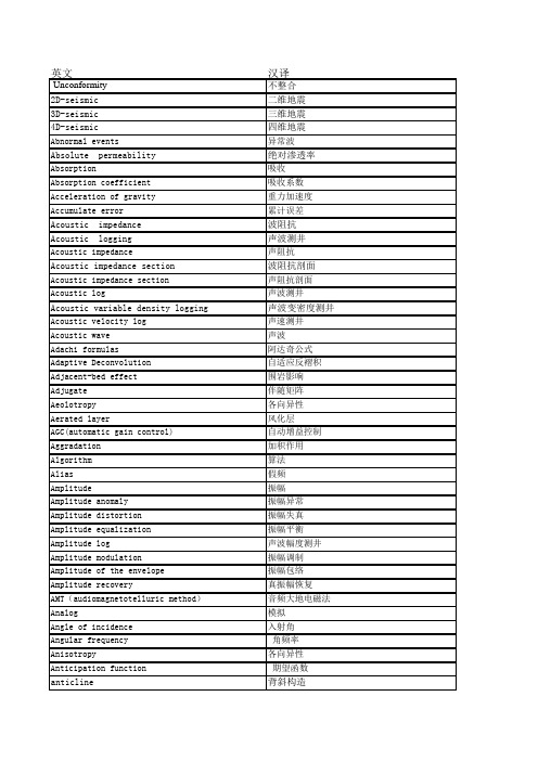
勘查技术与工程专业英语
英文汉译Unconformity不整合2D-seismic二维地震3D-seismic三维地震4D-seismic四维地震Abnormal events异常波Absolute permeability绝对渗透率Absorption吸收Absorption coefficient吸收系数Acceleration of gravity重力加速度Accumulate error累计误差Acoustic impedance波阻抗Acoustic logging声波测井Acoustic impedance声阻抗Acoustic impedance section波阻抗剖面Acoustic impedance section声阻抗剖面Acoustic log声波测井Acoustic variable density logging声波变密度测井Acoustic velocity log声速测井Acoustic wave声波Adachi formulas阿达奇公式Adaptive Deconvolution自适应反褶积Adjacent-bed effect围岩影响Adjugate伴随矩阵Aeolotropy各向异性Aerated layer风化层AGC(automatic gain control)自动增益控制Aggradation加积作用Algorithm算法Alias假频Amplitude振幅Amplitude anomaly振幅异常Amplitude distortion振幅失真Amplitude equalization振幅平衡Amplitude log声波幅度测井Amplitude modulation振幅调制Amplitude of the envelope振幅包络Amplitude recovery真振幅恢复AMT(audiomagnetotelluric method)音频大地电磁法Analog模拟Angle of incidence入射角Angular frequency 角频率Anisotropy各向异性Anticipation function 期望函数anticline背斜构造Aperture time时窗时间API unitAPI单位Apparent表观值Apparent density视密度Apparent dip视倾角Apparent polarity视极性Apparent resistivity视电阻率Apparent velocity视速度Apparent wavelength视波长Apparent wavenumber视波数Applied geophysics应用地球物理学Archie’s formulas阿尔奇经验公式Areal heterogeneity平面非均质Array排列,组合Arrival波至Asynchronous异步的Attenuation衰减Attribute属性,品质Autoconvolution自褶积Autocorrelation自相关Autocovariancet自协方差Auxiliary key horizon辅助标准层Average平均Average velocity平均速度Average velocity平均速度AVO technique AVO技术Axis轴Azimuth方位角,方位Background背景Balanced section平衡剖面Balancing a survey平差Band频带Band-pass通频带Bandwidth带宽Barrier layer隔层Base lap底超Base line基线Base map草图,底图Base station基点Base-line shift基线偏移Basin盆地bedding层理Bias偏差;偏流;偏压;偏磁Bimodal双峰的Bin面元Binary二进制Binate重采样bipole双极bland zone盲区block数据块borehole televiewer井下电视bouguer anomaly布格异常Bouguer correction布格校正boundary conditionBright spot亮点Bulk porosity总孔隙度caprock盖层Chemical sedimentary rock化学沉积岩Clastic sedimentary rock碎屑沉积岩Clay mineral粘土矿物Clean sandstone model纯砂岩模型CMS(chemical remanent magnetization)化学剩磁Compensate neutron log补偿中子测井Complex cycle复合旋回Comprehensive log interpretation测井资料综合解释Concentric folding同心褶皱Connectivity砂体连通性continuation延拓contour等值线convergence收敛Converted wave转换波convolution褶积Core岩芯corer取芯器,取样器correction校正correlation对比;相关;匹配Correlation coefficient相关系数Correlation filter相关滤波COS (common offset stack)共炮检距叠加Cosine law余弦定理coupling耦合Covariance协方差creep蠕变Critical angle临界角Critical damping临界阻尼Crooked line弯曲线测量Cross十字Cross bedding交错层理Crosscorrelation filter互相关滤波crossplot交会图Cross-section剖面;截面Curie point居里点curl旋度Curvature曲率Curve fitting曲线拟合Cycle skip周波跳跃Cylindrical divergence圆柱状发散datum基准面Decay constant衰减常数Decay curve衰减曲线decimate重采样Decimate重采样Declination磁偏角Decollement滑脱面Decomposition分辨Deconvolution反褶积Delay time延迟时间Demodulation解调Density logging密度测井Density contrast密度差Depositional remanent magnetism沉积剩余磁性Depositional sequence沉积层序Depth map深度图Depth migration深度偏移Depth of investigation勘探深度Development seismic开发地震Development well logging开发测井Diaper底避构造Dielectric log介电常数测井Dielectric consist介电常数Differential差异;差分Differential compaction差异压实作用Diffraction绕射Diffraction stack绕射叠加Digital数字Dim spot暗点Dip倾角Dip angle地层倾角Dip direction地层倾向Dip line倾斜测线Dip moveout倾角时差Dipole偶极Direct detection直接检测Direct problem正问题Direct wave直达波Dirichlet condition狄利赫来条件Discrete fourier transform离散傅里叶变换Disharmonic folding不谐和褶皱Dispersion curve频散曲线Displacement偏离Displacement current位移电流Dissertation Abstracts International国际学位论文文摘Distortion畸变Distributed分布Divergence发散;散度Domain域Dome丘,穹隆Dominant frequency主频Doppler effect多普勒效应Downdip下降,下倾,Downlap下超Drape披盖Drift漂移Drill钻机Dual water model双水模型Dynamic correction动校正Dynamic memory动态存储器Dynamic range动态范围Dynamite烈性硝甘炸药Effective permeability有效渗透率Effective porosity有效孔隙度Eigenvalue特征值Eigenvector特征向量Elastic弹性的Elastic constants弹性常数Elastic deformation弹性常数Elastic impedance波阻抗Elastic limit弹性限度Elastic moduli弹性模量Elastic wave弹性波Electromagnetic propagation log电磁波传播测井Elevation correction高程校正emulate仿真End-on端点放炮Engineering geophysics工程地球物理enthalpy焓entropy熵envelope包络equalization均衡Equipotential surface等位面Event同相轴Expectation期望Exponential decay指数衰减Factor analysis因子分析Fade切除Fan-filter扇形滤波Fast fourier transform快速傅里叶变换fault断层Fault断层Fault bench断阶构造Fault drop落差Fault line断层线Fault surface断层面Fault throw断距feedback反馈Fence diagram栅状图Fence effect栅栏效应Fermat’s principle费马原理Filter滤波器Finite-difference method有限差分法Finite-element method有限元法Firing引爆First break初至Flat spot平点Flattened section已拉平的剖面Flexural-slip folding挠曲滑动褶皱Floating datum浮动基准面Flow chart流程图Flushed zone冲洗带flute切除flux通量Flyer检波器串fold地层褶曲folding褶皱format格式formation地层Formation occurrence地层产状Formation sensitivity储层敏感性Formation strike地层走向Formation evaluation地层评价Formation resistivity factor地层电阻率因子Formation-density log地层密度测井Forward solution正演解four-property relationship四性关系fracture裂缝Fresnel diffraction菲涅尔衍射Gas hydrate天然气水合物geochronology地质年代学geodesy大地测量学Geodetic latitude大地纬度Geodetic reference system大地参考系统Geodynamics project地球动力学研究计划Geographic latitude大地纬度geoid大地水准面Geomagnetic pole地磁极Geomagnetic reversal地磁反转Geometric factor几何因子Geometric spreading几何扩散Geophone检波器Geophone检波器组合Geophone array检波器组合Geophone interval检波距Geophone pattern检波器组合geophysicist地球物理学家Geophysics survey地球物理测量geosyncline地槽Geothermal gradient地热梯度ghost虚反射graben地堑graben地堑gradient梯度gravimeter重力仪Gravitational folding重力褶皱Gravitational potential重力位gravity重力Gravity anomaly 重力异常Gravity reduction重力改正Gravity survey重力测量Grid网格Ground roll地滚波Group interval组距Group velocity群速度Guided wave导波hammer重锤Handshake信息交换harmonic谐波Harmonic function调和函数Head wave首波Heat conductivity热导率high-resolution seismic高分辨率地震Horizontal bedding水平层理Horizontal slice水平切片Horizontal spot平点horst地垒horst地垒Igneous rock火成岩Index bed标准层Induced polarization激发极化Inductance电感induction感应Induction electrical survey感应电测井Induction logging感应测井inductivity磁导率Information extracted信息提取Innerbeded heterogeneity层内非均质Instantaneous frequency瞬时频率Instantaneous phase瞬时相位instruction指令insulator绝缘体Integrated circuit集成电路Integrated geophysics综合地球物理Integration混波Intelligent terminal智能终端intensity强度Intensity of magnetization磁化强度Interactive人机联作Interbed夹层Interbed multiple层间多次波Interbeded heterogeneity层间非均质Intercept distortion截断失真Interpretation解释Invaded zone冲洗带Inverse cycle反旋回Inverse draw逆牵引Inversion problem反问题Key bed标志层Laterolog侧向测井Layer velocity section层速度剖面Layer velocity层速度Level calibration层位标定litho-density log岩性密度测井Log interpretation model测井解释模型Log response equation测井响应方程Logging tool standardization测井仪器标准化logging-constrained reversion测井约束地震反演Logs测井曲线Material balance equation物质平衡方程Metamorphic rock变质岩Microelectrode log微电极测井microfacies沉积微相migrated-stacked section偏移叠加剖面Model of bulk-volume rock岩石体积模型Monoclinal strata单斜层mute切除Natural gamma-ray logging自然伽马测井Natural gamma ray spectral log自然伽马能谱测井normal正断层Normal cycle正旋回Normal draw正牵引Normal fault正断层Normal-moveout corrections正常时差校正Nosing structure鼻状构造Oil layer group油层组Oil sandbody油砂体one-step 3D-migration一步三维偏移Parameter参数permeability渗透率Permeability max-mean ratio渗透率突进系数permeability max-min ratio渗透率级差permeability variation coefficient渗透率变异系数Petrophysical property油层物性phase spectrum相位谱Pinch out地层尖灭Polarity reversal极性反转Pore throat孔隙喉道potential势能Primary pore原生孔隙prospect勘探工区,勘探远景区Prospecting seismology勘探地震学Random随机的Ray tracing射线追踪Reciprocity principle互换定理Reconnaissance踏勘,Recover恢复,还原Recovery收获率Recursive filter递归滤波Reef礁Reflecting point反射点Reflection反射Reflection factor反射系数Reflection character analysis反射波特征分析Reflection coefficient反射系数Reflection polarity反射波极性Reflection strength反射波强度Reflection survey反射波勘探Reflector反射界面Refraction折射Refraction wave折射波Refractive index折射系数,折射率Refractor折射界面,折射层Regression海退Regression analysis回归分析Relative permeability相对渗透率Relaxation time驰豫时间Reserving space储集空间reservoir储集层Reservoir fundamental parameter储集层基本参数Resistivity logging电阻率测井Resistivity index电阻率指数resolution分辨率Resolution分辨率Resonance共振Reverberation鸣震reverse逆断层Reverse fault逆断层RMS(root-mean-square)均方根Rock stratum岩层Rock structure岩石构造Rock texture岩石结构Rotational旋转断层Sample ratio取样间隔Sampling theorem采样定理Sand砂岩Sands group砂层组saturation饱和度scattering散射Seal rock封堵层Secondary pore次生孔隙Secondary field二次场Secondary porosity次生孔隙度Sedimentary cycle沉积旋回Sedimentary facies沉积相Sedimentary rhythm沉积韵律Sedimentary rock沉积岩Seis检波器, 地震检波器seiscrop等时切片图Seislog地震测井seisloop三维测量排列Seismic exploration地震勘探Seismic facies地震相Seismic inversion地震反演Seismic normalization地震正演Seismic wavelet地震子波Seismic datum地震基准面Seismic discontinuity地震不连续面Seismic event地震同相轴Seismic exploration地震勘探Seismic facies地震相Seismic log地震测井Seismic map地震构造图Seismic profile地震剖面Seismic pulse地震脉冲Seismic record地震记录Seismic refraction method地震折射波法Seismic section地震剖面Seismic sequence analysis地震层序分析Seismic stratigraphy地震地层学Seismic survey地震勘探Seismic tomography地震层析seismic-geologic section地震地质剖面seismic-sequent stratigraphy地震层序地层学Seismogram地震记录Seismograph地震仪Seismologist地震学家Seismology地震学sensitivity灵敏度Series of development strata开发层系Shale泥岩Shaly sandstone model泥质砂岩模型Shear wave横波Shielding屏蔽,屏蔽层Shoot爆炸,放炮,激发Signal to noise ratio信噪比Significance level显著性水平Similar folding相似褶皱simulated annealing模拟退火Single layer小层Singularity奇点,奇异点,奇异性Skin depth趋肤深度Smoothing平滑SP(spontaneous potential or self potential )自然电位Spacing电极距,源距Spatial aliasing空间假频Spectrum谱,频谱Spherical球面的Spill point溢出点Spontaneous potential log自然电位测井Spread排列,布置Spreading发散,扩散Stacked section水平叠加剖面stacked-migrated section叠偏剖面Stacking velocity叠加速度Standard标准的Static correction静校正Statistical统计的Storage存储器Storm扰动Strain应变,形变,胁变Strata overlap地层超覆Stratigraphic interpretation地层学解释Stratum loss地层缺失Streamer拖缆Strike slip走向滑动断层Stringer高速薄层Structural geology构造地质Structure构造Superposition叠加定理Supervisor野外监督Suppression压制Surface wave面波Survey测量,勘测,勘探Susceptibility磁化率Synchronous同步的syncline向斜构造Synthetic seismogram合成地震记录Synthetic seismogram合成地震记录Systematic error系统误差TAR(ture-amplitude recovery )真振幅恢复Tectonic map大地构造图Telluric current大地电流Tensor张量Terrain correction地形校正Thermal conductivity热导率Three instantaneous parameter section三瞬剖面throat eveness coefficient喉道均质系数throat mean喉道平均值throat mid-value喉道中值Thrust fault冲断层Thrust fault逆掩断层Tie-line联接测线Time-distance curve时距曲线Time-slice map等时切片Time-variant时变的Tomography层析成像技术Toplap顶超Topographic correction地形校正Total reflection全反射Trace analysis道分析Trace equalization道均衡Trace gather道集Trace integration道积分Trace inversion道反演Trace sequential道序编排transform转换断层Transform fault转换断层Transformed wave转换波Transgression海侵Transient electromagnetic method瞬变电磁法Transistor晶体管Transmission coefficient透射系数Transverse wave横波Transversely isotropic横向各向同性Trap圈闭Travel path传播路径Tree-dimensional survey三维勘探Trough波谷Truncation error截断误差Tumescence火山隆起two-step 3D-migration二步三维偏移Uncertainty不定性,不确定性,不可靠性Updip上倾放炮Uphole geophone井口检波器Upward continuation向上延拓Valley波谷Variable area变面积Variable density变密度Variance方差Vector矢量Velocity analysis速度分析Velocity inversion速度倒转Velocity layering速度分层Velocity spectrum速度谱Velocity sweeping速度扫描Vibration survey振动测量Vibrator振动器Video display视频显示Virtual memory虚拟存储器Viscoelastic粘弹性的Viscosity粘度,粘滞性Water saturation含水饱和度Wave group波组wave equation波动方程Wave equation migration波动方程偏移Wave impedance波阻抗Wave velocity波速Waveform波形Wavefront波前Wavelet地震子波Wavelet equalization子波均衡Wavelet extraction子波提取Wavelet processing子波处理Wavenumber波数Wavy bedding波状层理Weathering 风化层Weathering风化层,低速带Weathering correction低速带校正Weathering layer风化层,低速带Weathering shot低速带测定Weighted array加权平均加权组合Weighted average加权平均Well logging测井Well logging series测井系列White白噪声White noise level白噪水平Young’s modulus杨氏模量Zero-phase零相位Zoeppritz’s equation佐普里茨方程。
福州大学紫金矿业学院资源勘查工程选矿概论期末复习题
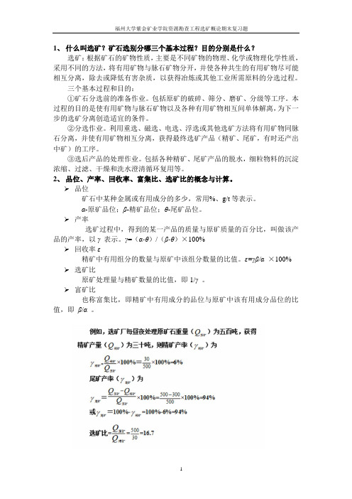
1、什么叫选矿?矿石选别分哪三个基本过程?目的分别是什么?选矿:根据矿石的矿物性质,主要是不同矿物的物理、化学或物理化学性质,采用不同的方法,将有用矿物与脉石矿物分开,并使各种共生的有用矿物尽可能相互分离,除去或降低有害杂质,以获得冶炼或其他工业所需原料的分选过程。
三个基本过程和目的:①矿石分选前的准备作业。
包括原矿的破碎、筛分、磨矿、分级等工序。
本过程的目的是使有用矿物与脉石矿物以及各种有用矿物相互间单体解离,为下一步的选矿分离创造适宜的条件。
②分选作业。
利用重选、磁选、电选、浮选或其他选矿方法将有用矿物同脉石分离,并使有用矿物相互分离,获得最终选矿产品(精矿、尾矿,有时还产出中矿)的工序。
③选后产品的处理作业。
包括各种精矿、尾矿产品的脱水,细粒物料的沉淀浓缩、过滤、干燥和洗水澄清循环复用等。
2、品位、产率、回收率、富集比、选矿比的概念与计算。
品位矿石中某种金属或有用成分的多少,常用%、g/t等表示。
α-原矿品位;β-精矿品位;θ-尾矿品位。
产率选矿过程中,得到的某一产品的质量与原矿质量的百分比,叫做该产品的产率,以γ表示。
γ=(α-θ)/(β-θ)×100%回收率ε精矿中有用组分的数量与原矿中该组分数量的比值。
ε=γβ/α ×100% 选矿比原矿处理量与精矿数量的比值,即1/γ。
富矿比也称富集比,即精矿中有用成分的品位与原矿中该有用成分品位的比值,即β/α。
3、工艺矿物学的地位;研究内容有哪些?①、工艺矿物学是地质、选矿、冶炼等部门技术进步的重要依托。
(1)为选矿试验提供相应的矿石特征资料,积极走向资源综合利用的全过程;(2)有效参与到地质勘探、矿床评价、储量计算等基础地质过程中;(3)注意对矿石性质的地质成因分析和微观机理分析;(4)有效发挥学科在国民经济中的作用,积极开展服务于本学科的专用测试仪器、方法和手段的研究。
②、2.1原料与产物中的矿物组成查清原料与产物里的所有矿物种属;判明各主要矿物成分的变化规律;考查伴生物质特征;确定各组分的含量。
同位素地球化学复习资料
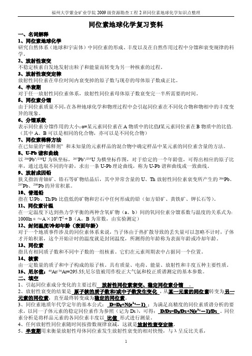
14、硫、碳同位素分馏作用? 答:Ⅰ、S ⑴、化学动力学分馏:主要指硫在氧化-还原反应过程中所产生的硫同位素分馏; ⑵、生物动力学分馏:自然界硫同位素组成变化重要原因之一是厌氧细菌引起硫酸盐离子的还原作 用; ⑶、平衡分馏:高氧化的硫富34S,SO42- >SO32- >SO2 >Sx > H2S > S2-(原因:键强)。 Ⅱ、C ⑴、氧化-还原反应:CH4 +2H2O <=> CO2+4H2 ⑵、光合作用:6CO2 +6H2O => C2H12O6+6O2(有机物中将富集 12C) ⑶、同位素交换反应:13CO2(气) +12CO32-(液) <=> 12CO2(气) +13CO32-(液) 一般规律: δ13C‰:CO<CH4<C<CO2<CO32-即:还原态、有机物富集12C, 氧化态、无机物富集13C。
- 1、下载文档前请自行甄别文档内容的完整性,平台不提供额外的编辑、内容补充、找答案等附加服务。
- 2、"仅部分预览"的文档,不可在线预览部分如存在完整性等问题,可反馈申请退款(可完整预览的文档不适用该条件!)。
- 3、如文档侵犯您的权益,请联系客服反馈,我们会尽快为您处理(人工客服工作时间:9:00-18:30)。
Chapter1an introduction to geology1.Igneous rocks are produced primarily by the deposition and consolidation of surface materials such as sand and mud.BA.true;B.false2.Which statement is NOT correct?AA.metamorphic rocks always melt and become magmaB.igneous rocks may undergo metamorphismC.sedimentary rocks can be weatheredD.when magma crystallizes,it becomes igneous rock3.Materials deposited by turbidity currents contribute to the formation of __A_.A.deep-sea fans;B.alluvial fansC.floodplains;D.beaches4.All three parts (spheres)of Earth's physical environment areinteracting in this scene.AA.true;B.false 5.Earth’s physical environment is traditionally divided into three parts:the solid Earth,the hydrosphere,and the ____C______.A.ecosphere;B.metasphereC.atmosphere;D.thermosphere6.Earth's gaseous envelope is the ____C______.A.hydrosphere;B.lithosphereC.atmosphere;D.biosphere7.Which is the thinnest of Earth's differentlayers?CA.mantle;B.outer coreC.crust;D.stratosphere8.Which one of the following is NOT one of the three broad subdivisions of the ocean floor?DA.ocean basin floor;B.continental marginC.oceanic ridgeD.coastal plain9.Mountain belts are one part or subdivision of regions called shields.BA.true;B.false10.The crust and mantle have about the same thickness.BA.true;B.false11.The__________is the zone within Earth that includes the crust and uppermost mantle.BA.paleosphere;B.lithosphereC.outer core;D.asthenosphere12.This basic rock type forms when already existing rock is subjected to great pressures and/or intense heat.AA.metamorphicB.sedimentaryC.igneous13.The____D______system is a broad,rugged,elevated feature on the ocean floor that formsa continuous belt that winds around the globe.A.Emperor chainB.asthenosphereC.deep-ocean trenchD.mid-ocean ridgeE.continental rise14.Which portion of the continental margin is steepest?AA.continental slopeB.continental shelfC.continental rise15.This diagram represents a ___A_______continental margin.A.activeB.riftingC.abyssalD.passive16.Oceans blanket about ___A_______percent of Earth's surface.A.70%B.10%C.90%D.50%E.30%17.Continental crust is thicker than oceanic crust.AA.trueB.false18.This term is used to describe the totality of all life on Earth.BA.phytosphereB.biosphereC.zoosphereanosphere19.Regions consisting of large,relatively flat expanses of ancient metamorphic rocks within the continental interior are called __A________.A.shieldsB.stable platformsC.mountain beltsD.abyssal plains20.On the ocean side of the continental shelf,the steep continental slope merges into a more gradual incline known as the ___D_______.A.abyssal plainB.deep-ocean trenchC.seamountD.continental rise21.What are the three basic classes of rocks described in the rock cycle?BA.crustal,lithospheric,transitionalB.sedimentary,igneous,metamorphicC.volcanic,continental,lithosphericD.weathered,sedimentary,volcanic22.The asthenosphere is a very important zone within Earth's upper mantle.AA.trueB.false23.Which one of the following is NOT a principal division of the solid Earth?BA.crustB.troposphereC.outer coreD.mantleE.inner core24.The two types of continental margins are passive and active.AA.trueB.false25.Which of the following is NOT one of the three major geological regions of continents?BA.stable platformsB.abyssal plainsC.shieldD.mountain belts26.Deep-ocean trenches are associated with passive continental margins.BA.trueB.false27.One-half of the atmosphere lies below an altitude of_D__kilometers.A.3.7B.7.5C.1.4D.5.6Chapter2plate tectonic:a scientific revolution unfolds1.Convergent plate margins occur where two plates are moving toward one another and the movement is accommodated by:DA.Earth getting larger.B.one plate sliding horizontally past the other.C.new material being added at transform fault boundaries.D.one plate descending beneath the other.2.Most volcanic island arcs are located near____D______.A.an oceanic ridgeB.a transform faultC.a rift valleyD.a deep-oceanic trench3.Which of these plates is the largest?BA.NazcaB.PacificC.Australian-IndianD.African4.According to the theory of plate tectonics,plates interact mainly______A____.A.along plate boundariesB.near the center of each plate where stress is greatestC.on the underside of each plate5.As plates move apart,the gap between them is filled with molten rock called___C_______.A.graniteB.silicaC.magmaD.gooze6.New oceanic crust is created at divergent boundaries at a rate of about:BA.5centimeters per centuryB.5centimeters per yearC.5meters per yearD.5kilometers per year7.At convergent plate boundaries_______B___.A.new lithosphere is formingB.old lithosphere is being destroyedC.neither a or bD.both a and b8.At convergent plate boundaries,two plates______A____.A.move togetherB.grind past each otherC.reverse directionD.move apart9.Collision mountain belts form because continental crust is too buoyant to undergo appreciable subduction,and results in a collision between continental fragments.AA.trueB.false10.Subduction occurs because:CA.forces created at spreading centers are causing plates to move togetherB.the sediment that caps the oceanic crust acts as a lubricant to aid subductionC.the subducting lithosphere has a greater density that the underlying asthenosphereD.the lithosphere is warm and weak11.The region where oceanic lithosphere descends into the asthenosphere is called___D__.A.an accretionary wedgeB.a hot spotC.a mantle plumeD.a subduction zone12.Earth's rigid outer layer overlies a zone of weaker and hotter material known as the:CA.cryosphereB.lithosphereC.asthenosphereD.mesosphere13.Along the San Andreas Fault,the Pacific plate is moving toward the northwest,relative to the North American plate.AA.trueB.false14.At divergent plate boundaries,two plates__D________.A.move togetherB.grind past each otherC.join to produce a larger plateD.move apart15.When an oceanic plate and a continental plate converge,a(n)____B______is formed alonga subduction zone.A.asthenospheric riseB.oceanic trenchC.oceanic ridgeD.transform faultE.rift16.Transform faults occur where plates slide past one another and generate new lithosphere.BA.trueB.false17.Earth's rigid outer layer is called:BA.cryosphereB.lithosphereC.asthenosphereD.mesosphere18.Great earthquakes can be generated at transform fault boundaries.AA.trueB.false19.The lithosphere is thickest under the oceans and thinnest beneath the continents.BA.trueB.false20.What is the main factor that triggers the formation of magma when a cold slab of oceanic lithosphere is subducted?AA.the subducting slab supplies water to a wedge of hot mantle rock thereby lowering its melting temperatureB.friction between the subducting slab and the mantle rock generates enough heat to trigger meltingC.the subducting slab carries sediment deep into Earth where it meltsD.the subducting plate displaces hot mantle rock which rises to form magma21.Most volcanic island arcs are located in the_____A_____.A.western PacificB.Gulf of MexicoC.Caribbean SeaD.South Atlantic22.When divergent plate boundaries continue to operate within a continent,the landmass may _____CD_____.Select ALL that apply.A.get much thickerB.begin to subduct into the mantleC.develop a rift valleyD.split into two smaller continents23.Volcanoes associated with continental volcanic arcs generally_____C_____.A.are located on islands like HawaiiB.emit mainly lava flowsC.erupt explosivelyD.erupt on the average of every1000years24.What layer of Earth allows the plates to move?CA.cryosphereB.lithosphereC.asthenosphereD.mesosphere25.Older oceanic lithosphere is cooler,thicker,and denser than young oceanic lithosphere.AA.trueB.false26.At transform fault boundaries,two plates_____B_____.A.move togetherB.grind past each otherC.join to produce a larger plateD.move apart27.The theory of plate tectonics holds that the outer rigid layer of Earth is broken into about a dozen major segments called shields.BA.trueB.false28.The Aleutian Islands,Tonga Islands,and Japan are examples of_____C_____.A.continental volcanic arcsB.continental platformsC.volcanic island arcsD.a chain of seamounts29.Which one of these mountain belts was NOT formed by a continental collision?BA.HimalayasB.AndesC.AppalachiansD.Urals30.The mechanism that has generated the floors of the world's oceans is called_______D___.A.ocean floor convergenceB.ocean floor constructionC.seafloor constructionD.seafloor spreading31.Most divergent boundaries are located:CA.in mountain regions such as the Alps and HimalayasB.in deep-ocean trenchesC.along oceanic ridgesD.in the center of large continents32.The mechanism that has generated the floors of the world's oceans is called____D______.A.ocean floor convergenceB.ocean floor constructionC.seafloor constructionD.a deep-oceanic trench33.The Andes and Cascades exemplify which of these features?DA.deep-oceanic trenchB.oceanic ridgeC.forearc basinD.continental volcanic arc34.Whenever a slab of oceanic lithosphere converges with a slab of continental lithosphere ______C____.A.the continental lithosphere descends into the asthenosphereB.the continental lithosphere gets pushed toward the ridgeC.the oceanic lithosphere descends into the asthenosphereD.the oceanic lithosphere gets pushed toward the ridge35.When two oceanic plates converge,and one plate descends to form a trench,material from the melting plate often forms a(n)_____B_____at the surface.A.continental riftB.volcanic island arcC.oceanic ridgeD.mountain range36.Which of these water bodies was once a rift valley?Bke MichiganB.Red SeaC.Caspian SeaD.Black Sea37.At divergent plate boundaries_____A_____.A.new lithosphere is formingB.old lithosphere is being destroyedC.neither a or bD.both a and b38.Most of the largest plates____C______.A.consist primarily of oceanic crustB.are dominated by continental crustC.contain large amounts of both oceanic and continental crustChapter 3matter and minerals1.The ratio of silicon atoms to oxygen atoms is the same in each of the various silicate structures.B A.trueB.false2.What is the luster of the mineral illustrated in the following photograph?A A.glassy B.pearly C.earthyD.metallic3.Most rocks are aggregates of minerals.A A.trueB.false4.Identify the components of the following building block of most minerals.A A.A is silicon,B is oxygen B.A is oxygen,B is silicon C.A is silicon,B is silicon D.A is oxygen,B is oxygen5.All minerals have a crystal form.A A.trueB.false6.When minerals break evenly in more than one direction,cleavage is described by the number of planes exhibited and the angles at which they meet.A A.trueB.false7.This mineral exhibits cleavage.B A.trueB.false8.The most common group of rock-forming minerals is the ____B___.A.oxidesB.silicatesC.carbonatesD.sulfides9.Which one of the following is NOT included in the definition of a mineral?B A.inorganic B.unordered internal structure C.solidD.definite chemical composition10.Granite is a common mineral.B A.trueB.false11.Which of the minerals illustrated in the following photograph exhibits cubic cleavage?B A.left B.center C.right12.A cubic centimeter of quartz and gold weighs 2.7and about 20grams respectively.This indicates that __A_.A.gold has a much higher specific gravity than quartzB.gold is much harder than quartzC.gold is much more elastic than quartzD.gold has a greater luster than quartz13.All silicate minerals contain which of the following two elements?C A.iron,magnesium B.iron,silicon C.silicon,oxygenD.magnesium,silicon14.Which one of the following sets of two terms describes how a mineral responds to mechanical impact?C A.luster,hardness B.hardness,cleavage C.cleavage,fractureD.fracture,crystalform15.Which one of the following is NOT a silicate mineral?DA.feldsparB.quartzC.olivineD.calcite16.All ferromagnesian minerals contain one or both of these elements:AA.iron,magnesiumB.magnesium,potassiumC.sodium,siliconD.potassium,sodium17.Which one of the following is NOT a property used to identify minerals?CA.hardnessB.streakC.textureD.crystal form18.The silicon-oxygen tetrahedron is a complex ion.AA.trueB.false19.Which of these mineral properties may be of minimal value in identifying the mineral quartz?CA.lusterB.hardnessC.colorD.crystal form20.Which of these silicate minerals exhibits a sheet structure?BA.quartzB.muscoviteC.olivineD.feldsparChapter4igneous rocks1.Igneous rock originates when hot,molten material called_D__cools and crystallizes.A.sedimentB.skarnC.firnD.magma2.Rocks that contain voids left by gases that escape as lava solidifies are said to exhibit a(n) __B___texture.A.phaneriticB.vesicularC.aphaniticD.porphyritic3.Which of these rocks is composed almost entirely of ferromagnesian minerals?DA.graniteB.basaltC.rhyoliteD.peridotite4.Igneous rocks that form from the last minerals to crystallize from magma will have a(n) ____D_composition consisting of quartz,potassium feldspar,and sodium-rich plagioclase feldspar.A.andesitic(intermediate)B.basaltic(mafic)C.mafic(felsic)D.granitic(felsic)5.Igneous rocks rich in dark silicate minerals with about50percent silica are said to have a(n) _____B__composition.A.aphaniticB.basalticC.rhyoliticD.granitic6.An igneous rock with less than15percent dark minerals would have a(n)____D_ composition.A.basaltic(mafic)B.detrital(lithic)C.andesitic (intermediate)D.granitic (felsic)7.In a rock with a porphyritic texture,the large crystals are referred to as ____C__.A.groundmass B.erratics C.phenocrystsD.orthoblasts8.Which one of the following is NOT a possible product of a volcanic eruption?D A.ash B.pyroclastic debris C.cindersD.marble9.When the minerals in an igneous rock cannot be identified,the composition can be estimated based on the percentage of phenocrysts present in the rock.B A.trueB.false10.Which one of the following greatly affects both the size and arrangement of mineral crystals in an igneous rock?Dposition of the rock surrounding the magmaB.specific gravity of the magma or lavaC.rate of tectonic upliftD.rate of cooling of the magma or lava11.Examine the following close-up of an igneous rock.The rock has a(n)___A_texture.A.phaneriticB.aphaniticC.porphyriticD.glassy12.Examine this aphanitic igneous rock which has a granitic (felsic)composition.The rock's name is ___B__.A.dioriteB.rhyoliteC.graniteD.basalt13.In a rock with a porphyritic texture,the smaller crystals are referred to as ______A____.A.groundmass B.erratics C.phenocrystsD.orthoblasts14.Igneous rocks are classified based on their texture and mineral composition.A A.falseB.true15.What is the texture of this rock?B A.aphaniticB.glassyC.porphyriticD.andesite16.Igneous rocks that form when lava solidifies are classified as extrusive or volcanic igneous rocks.A A.trueB.false17.Basalt makes up the ocean crust as well as lava flows and volcanic structures on land.A A.trueB.false18.This rock most likely formed in which of these environments?C A.a submarine lava flowB.the top portion of a surface lava flowC.a large,deep intrusive bodyD.a very thin and shallow intrusivebodyChapter 5volcanoes and other igneous activity1.Intrusive igneous bodies are classified according to their shape and orientation with respect to the host rock.A A.trueB.false2.What type of volcano may produce a nu ardente or lahar?C A.shield volcano B.cinder cone posite cone3.What type of volcano is composed of interbedded lavas and pyroclastic deposits?C A.shield volcano B.cinder coneposite cone4.What type of intrusive feature is this?B A.dike B.sill ccolith D.batholith5.What type of intrusive feature is this?C A.dike B.sillccolithD.batholith6.What type of volcano is typically thelargest?AA.shieldvolcanoB.cinder coneposite cone7.Magmas thatproduce _A__rock contain about 50percent silica and tend to be quite ____.A.basaltic;fluid B.rhyolitic;viscous C.rhyolitic;fluidD.basaltic;viscous8.Which one of the following is NOT a primary factor of magma that directly determines the nature of a volcanic eruption?D A.temperature B.amount of dissolved gases positionD.volume9.What type of volcano is composed mostly of basaltic lava flows?A A.shield volcano B.cinder coneposite cone10.What type of volcano has the steepest slopes?B A.shield volcano B.cinder coneposite cone11.What type of intrusive feature is this?D A.dike B.sill ccolith D.batholith12.What type of volcano produces the most violent eruptions?C A.shield volcanoB.cinder coneposite cone13.A volcano that takes the shape of a broad,domed structure is called a _B___volcano.A.cinderB.shieldposite14.What type of intrusive feature is this?A A.dike B.sill ccolithD.batholith15.What type of intrusive feature is this?A A.dike B.sill ccolithD.batholith16.Exemplified by the Hawaiian Islands,this type of volcano tends to be the largest on Earth.B A.cinderB.shieldposite17.__A_cones,such as Sunset Crater,Arizona,tend to have very steep slopes.A.cinderB.shieldposite18.This type of magma,with a silica content of about 70percent,has the greatest tendency to form pyroclastics.A A.rhyolitic B.andesitic C.migmaticD.basaltic19.This type of magma,with about a 60percent silica content,tends to form composite cones.B A.rhyolitic B.andesitic C.migmaticD.basaltic20.What type of volcano is typically the smallest?B A.shield volcano B.cinder conepositeconeChapter6weathering and soil1.The atmospheric gas that forms a weak acid when dissolved in water is__D___.A.oxygen;B.argon;C.nitrogen;D.carbon dioxide2.When a rock undergoes___B_______,such as frost wedging,it is broken into smaller and smaller pieces.A.chemical weathering;B.mechanical weathering;C.dissolution;D.lithification3.In which climate would the rate of chemical weathering likely be highest?AA.warm and moist;B.cold and dry;C.cold and moist;D.warm and dry4.Which one of the following is NOT a product of the chemical weathering of granite?BA.clay;B.sulfur dioxide;C.potassium ions;D.silica in solution5.Which term is used to describe chemical weathering processes?DA.disintegration;B.sheeting;C.thermal expansion;D.decomposition6.Which“tough”mineral is most likely to survive extensive chemical weathering and form sand grains on beaches or dunes?DA.clay;B.sheeting;C.olivine;D.quartz7.When some rocks weather more rapidly or more slowly than others,it is called:Cpound weathering;B.spheroidal weathering;C.differential weathering;D.sheeting8.Unloading and sheeting are associated with:DA.thermal expansion;B.frost wedging;C.talus slopes;D.exfoliation domes9.If granite and basalt were exposed in an area with a hot and humid climate:BA.the granite would weather most rapidly;B.the basalt would weather most rapidly;C.both rocks would weather at the same rate;D.there is no way of knowing which rock type would weather most rapidly10.The formation of caves is associated with this form of chemical weathering.AA.dissolution;B.oxidation;C.hydrolysis;D.exfoliation11.Which list of silicate minerals shows the order in which they would weather from least resistant to most resistant?CA.quartz,olivine,potassium feldspar,amphibole;B.amphibole,olivine,quartz,potassium feldspar;C.olivine,amphibole,potassium feldspar,quartz;D.potassium feldspar,quartz,olivine,amphibole;12.The rate of weathering is influenced by:DA.climate;B.mineral composition of the rock;C.number of joints;D.all of the above;E.both A and C but not A13.Which statement regarding mechanical weathering is NOT true?DA.allows for faster rates of chemical weathering;B.is important in the formation of talus slopes;C.breaks rocks into smaller pieces;D.causes a major change in mineral composition;14.Which one of the following is NOT a product of the complete chemical weathering of the mineral potassium feldspar?DA.potassium ion(in solution);B.kaolinite(clay);C.bicarbonate ion(in solution);D.sodium hydroxide;E.silica;15.Which of the following is NOT associated with an external process?Bndslide;B.earthquake;C.weathering;D.glacier;E.stream16.Which of the following is NOT a mechanical weathering process?CA.frost wedging;B.unloading;C.hydrolysis;D.thermal expansion17.Breaking a rock into smaller pieces decreases the rate of chemical weathering.BA.true;B.false;18.Iron oxide is the product of which one of these weathering processes?AA.oxidation; C.hydrolysis;C.dissolution;18.When water freezes,its volume:BA.decreases;B.increases;C.remains unchanged;20.The feature pictured here is a(n)_____C_____.A.delta;B.exfoliation dome;C.talus slope;ccolith21.Two headstones,one marble and the other granite,were erected in the same New England cemetery150years ago.Which headstone is likely to have the least weathered,easiest to read inscription?BA.the marble headstone;B.the granite headstone;C.there should be little or no difference between the two headstones;Chapter7sedimentary rocks1.Angular pieces in a detrital sedimentary rock indicates the particles were not transported very far from their source prior to deposition.AA.true;B.false;2.Sedimentary rocks form when the products of_____E_____are transported to a new location where they are deposited and eventually__________into solid rock.A.melting;crystallized;B.deposition;eroded;C.crystallization;metamorphosed;D.tectonism;weathered;E.weathering;lithified3.Which common mineral found in igneous rocks is most abundant in detrital sedimentary rocks?DA.amphibole;B.biotite;C.plagioclase feldspar;D.quartz;4.The most common minerals in detrital sedimentary rocks are_A____.A.clay and quartz;B.clay and limonite;C.limonite and hematite;D.olivine and pyroxene;5.The sizes of particles in detrital sedimentary rocks often indicates the energy of the transporting medium.AA.true;B.false;6.Which rock type is most likely associated with a high-energy environment such as a turbulent stream?AA.conglomerate;B.shale;C.rock salt;D.Chert;7.Rock salt and rock gypsum are examples of__C__sedimentary rocks.A.detrital;B.biochemical;C.evaporate;8.The presence of abundant feldspar in a sedimentary rock suggests that advanced stages of chemical weathering have taken place.BA.true;B.false;9.Which accumulation of sediment would most likely exhibit good cross-bedding?Cndslide debris;B.cave deposits of travertine limestone;C.windblown sand(sand dune);D.salt flats in a desert basin;10.Evaporites are examples of biochemical sedimentary rocks.BA.true;B.false;11.This detrital sedimentary rock consists primarily of rounded gravel-size particles.DA.breccia;B.coquina;C.shale;D.conglomerate;12.The most abundant chemical sedimentary rock is___E_______.A.shale;B.conglomerate;C.sandstone;D.chert;E.none of the above;13.Which sedimentary rock listed below has a biochemical origin?CA.rock gypsum;B.travertine;C.coquina;D.shale;paction is a very important lithification process for which sediment?AA.mud;B.sand;C.gravel;15.Agate,jasper,and flint are all forms of chert.AA:true; B.false;16.Which one of the following is NOT a variety of limestone?DA.chalk;B.travertine;C.coquina;D.chert;17.Sediments precipitated by processes such as temperature change,evaporation,and chemical activity are called biochemical sediments.BA.true;B.false18.The common name for sediment consisting of particles between1/16mm and2mm is __D_.A.clay;B.silt;C.cobble;D.sand;E.gravel19.The single most characteristic feature of sedimentary rocks is____C______.A.their composition;B.their color;C.strata or beds;D.mineral crystals20.Detrital sedimentary rocks are made primarily of the products of mechanical weathering.BA.true;B.false21.Precipitation of dissolved material by the life processes of water-dwelling organisms produces material called____A______sediment.A.biochemical;B.secondary;C.detrital;D.clastic;22.Detrital sediments would predominate in all of the following environments except:BA.swamp;B.salt flat;C.river floodplain;D.delta;paction and cementation are examples of this process.BA.crystallization;B.lithification;C.weathering;D.fusion24.Which one of the following is NOT a sedimentary structure or feature that helps geologists interpret past geological conditions?AA.vesicles;B.mud cracks;C.particle sorting;D.ripple marks25.Limestone is composed chiefly of the mineral:AA.calcite;B.halite;C.feldspar;D.quartz;26.Geologists use____A_to distinguish among detrital sedimentary rocks.A.particle size;B.method of formation;C.color;D.the location of the source material;27.When substantial quantities of feldspar are present in sandstone,the rock is called:CA.agate;B.rock gypsum;C.arkose;D.travertine limestone;28.Which sedimentary rock consists of materials that originated and were transported as solid particles?AA.sandstone;B.rock salt;C.chert;D.travertine limestone;Chapter8metamorphic rocks1.Metamorphic rocks can form from other metamorphic rocks.AA.trueB.false2.During metamorphism,elongated crystals tend to recrystallize with an orientation that is ___B_______to the direction of greatest stress.A.parallelB.perpendicular3.The most common chemically active fluid involved in the metamorphic process is hot water containing ions in solution.AA.trueB.false4.Rocks subjected to intense heat when they are intruded by magma undergo a process called _C_.A.tectonic metamorphismB.searingC.contact metamorphismD.thermal modification5.Which one of the following is NOT an agent of metamorphism?CA.pressure(stress)B.heatC.crystallizationD.chemically active fluids6.Which of the following is least likely to occur during metamorphism?AA.formation of cross-beddingB.an increase in densityC.growth of larger crystalsD.development of a foliated texture7.When stress is applied unequally in different directions,it is termed______D____.A.confining pressureB.confining stressC.differential pressureD.differential stress8.Which one of the following metamorphic rocks is generally nonfoliated?A。
