GPS英文翻译
林业调查规划中GPS72的使用
•
•
如图所示,在布备点图的过程中只要事先 在小班周围定一个点,就可以计算出整个 小班的样地定位点。这样就可省去罗盘、 米绳等工具,两三个人的工作,一个人就 可以做了。 GPS与罗盘之间有10度的磁差,罗盘导线测 量的小班图布样地,要减10度后再计算GPS 定位点布样地择“设置”,然后左右按动 方向键选择“坐标”子页面; • 2 、用方向键将光标移动到“坐标格式”下的输入 框中; • 3、按下输入键打开坐标格式列表,上下移动方向键 选择“UserUTM Grid”,并按下输入键确认; • 4 、在出现的“自定义坐标格式”页面中,输入相 关的参数。 • ★伊春地区中央经线(E129°00.000′),投影比 例(+1.0000000),东西偏差(+500000.0),南北 偏差(该数值为0.0); • 5 、用方向键将光标移动到“存储”按钮上,并按 下输入键确认。
4、高度、速度、距离测量
• 高度测量
信息页面高度一栏显示海拔高度
• 速度、距离测算
速度测算及当前距离详见罗盘页面
5、记录沿途所走轨迹
• 记录沿途所走得轨迹,也就是我们常说 的航迹。GPS开机信号查找后为自动记录 航迹,在地图页面中黑色光标后的虚线 就代表所走轨迹。 • 如地图页面没走所走航迹,在主菜单中 进入航迹一项,导航页面按菜单键“设 置航迹记录”一项中把记录开启即可。
• 连续按两次菜单键将打开主 菜单页面。主菜单页面中包 括了旅行计算机、航迹、航 点、航线表等各种信息,以 及GPS的各种设置。方向键上 下移动黑色光标,确定按输 入键,返回上一界面按退出 键。
2、信息页面
• 可以显示当前的导航数 据,定位状态,GPS卫星 分布图,卫星信号强度, 日期和时间,以及坐标 等信息。方向键上下或 左右改变屏幕下方经纬 度和公里网的切换。
全球定位系统(GPS)术语及定义
全球定位系统(GPS)术语及定义全球定位系统(GPS)术语及定义【中华人民共和国国家标准GB/T 19391-2003 】2004-12-24 5:55:151范围本标准规定了全球定位系统(GPS)常用术语及定义。
本标准适用于GPS专业范围内的各种标准的制定、各类技术文件的编制,也适用于科研、教学等方面。
2通用术语2.1全球定位系统global positioning system(GPS)导航星navigation by satellite timing and ranging(NA VSTAR)一种卫星导航定位系统。
由空间段、地面控制段和用户段三部分组成.为伞球用户提供实时的三维位置、速度和时间信息。
包括主要为军用的精密定位服务(PPS)和民用的标准定位服务(SPS)。
2.2全球导航卫星系统global navigation satellite system(GLONASS)一种全球卫星导航定位系统:为全球用户提供实时的三维位置、速度和时间信息。
包括军用和民用两种服务。
2.3伽利略系统Galileo system一种民用全球卫星导航系统;2.4全球导航卫星系统global navigation satellite system(GNSS)由国际民航组织提出的概念。
GNSS的最终目标是由多种民用卫星导航系统组成,向全球民间提供服务。
并将由多国民间参与运行和控制的卫星导航系统。
GNSS也已经为国际海事组织(IMO)所接受。
欧洲的GNSS计划分为两个阶段,即GNSS-1和GNSS-2。
GNSS-1为EGNOS(欧洲地球静止轨道卫星导航重叠服务)系统,GNSS-2为Galileo(伽利略)系统。
2.5静地星/定位星系统Geostar/Locstar system一种卫星定位系统,利用两颗地球轨道静止卫星双程测距而实现定位功能,兼有简短报文通信能力。
2.6海军导航卫星系统navy navigation satellite system(NNSS)子午仪Transit是1960年由美国研制的卫星导航系统,为固定用户或低动态用户提供不连续定位信息。
浅谈GPS在生活中的应用

浅谈GPS在生活中的应用浅谈GPS在生活中的应用摘要:随着的广泛运用,使我们的生活发生了翻天覆地的变化,本文主要阐述了在我们生活中的应用。
关键词:GPS的开展生活应用优缺点一、GPS的介绍GPS定义GPS的全称是Global Positioning System,用英文翻译过来的全球定位系统,中文简称为“球位系〞。
GPS是20世纪70年代由美国陆海空三军联合研制的新一代空间卫星导航定位系统,主要目的用于陆、海、空三大领域提供实时、全天候和全球性的导航效劳,并用于情报收集、核爆监测和应急通讯等一些军事目的。
GPS开展GPS前身是美国军方研制的一种子午仪卫星定位系统,该系统用5到6颗卫星组成的星网工作,每天最多绕过地球13次,并且无法给出高度信息,在定位精度方面也不尽如人意。
然而,子午仪系统使得研发部门对卫星定位取得了初步的经验,并验证了由卫星系统进行定位的可行性,由于卫星定位显示出在导航方面的巨大优越性及子午仪系统存在对潜艇和舰船导航方面的巨大缺陷。
美国海陆空三军及民用部门都感到迫切需要一种新的卫星导航系统。
经过20余年的研究实验,耗资300亿美元,到1994年,全球覆盖率高达98%的24颗GPS 卫星星座己布设完成。
二、GPS生活中应用GPS在飞机系统中的应用按照机载导航系统的功能划分,GPS在航空导航中的应用以下几个方面:1、航路导航GPS和一种称之为接收机自主完善性监测的技术能满足洋区航路对GPS的导航精度、完善性?和可用性的要求,而且精度也能满足大陆空域航路的要求。
GPS的精度远优于现有任何航路用导航系统,这种精度的提高?和连续性效劳的改善有助于有效利用空域,实现最正确的空域划分和管理、空中交通流量?管理以及飞行路径管理,为空中运输效劳开辟了广阔的应用前景,同时也降低了营运本钱,?保证了空中交通管制的灵活性。
2、进场/着陆GPS及其广域增强系统完全?满足非精密进场/着陆对清度、完善性和可用性的要求;再用局域伪距差分技术/系统增强,能满足CAT-1、2类精密进场的要求。
GPS导航定位原理以及定位解算算法

GPS导航定位原理以及定位解算算法全球定位系统(GPS)是英文Global Positioning System的字头缩写词的简称。
它的含义是利用导航卫星进行测时和测距,以构成全球定位系统。
它是由美国国防部主导开发的一套具有在海、陆、空进行全方位实时三维导航与定位能力的新一代卫星导航定位系统。
GPS用户部分的核心是GPS接收机。
其主要由基带信号处理和导航解算两部分组成。
其中基带信号处理部分主要包括对GPS卫星信号的二维搜索、捕获、跟踪、伪距计算、导航数据解码等工作。
导航解算部分主要包括根据导航数据中的星历参数实时进行各可视卫星位置计算;根据导航数据中各误差参数进行星钟误差、相对论效应误差、地球自转影响、信号传输误差(主要包括电离层实时传输误差及对流层实时传输误差)等各种实时误差的计算,并将其从伪距中消除;根据上述结果进行接收机PVT(位置、速度、时间)的解算;对各精度因子(DOP)进行实时计算和监测以确定定位解的精度。
本文中重点讨论GPS接收机的导航解算部分,基带信号处理部分可参看有关资料。
本文讨论的假设前提是GPS接收机已经对GPS卫星信号进行了有效捕获和跟踪,对伪距进行了计算,并对导航数据进行了解码工作。
1地球坐标系简述要描述一个物体的位置必须要有相关联的坐标系,地球表面的GPS接收机的位置是相对于地球而言的。
因此,要描述GPS接收机的位置,需要采用固联于地球上随同地球转动的坐标系、即地球坐标系作为参照系。
地球坐标系有两种几何表达形式,即地球直角坐标系和地球大地坐标系。
地球直角坐标系的定义是:原点O与地球质心重合,Z轴指向地球北极,X轴指向地球赤道面与格林威治子午圈的交点(即0经度方向),Y轴在赤道平面里与XOZ构成右手坐标系(即指向东经90度方向)。
地球大地坐标系的定义是:地球椭球的中心与地球质心重合,椭球的短轴与地球自转轴重合。
地球表面任意一点的大地纬度为过该点之椭球法线与椭球赤道面的夹角φ,经度为该点所在之椭球子午面与格林威治大地子午面之间的夹角λ,该点的高度h为该点沿椭球法线至椭球面的距离。
GPS实时监控外文翻译
GPS实时监控外文翻译(文档含中英文对照即英文原文和中文翻译)原文:GPS Real-Time Supervisory System and Application in the Construction of FaceRockfill DamHUANG Sheng xiang LIU Jingnan ZENG Huai'enABSTRACTAccording to the quality control needs of filling construction of the face rockfill dam, by means o f the global satellite positioning technology , the wireless data communication technology, the computer technology and the data processing and analysis technology, and integrating with the roller compaction machine, the GPS real-time supervisory system is developed in this paper. It can be used to real-timely supervise the construction quality of the roller compaction for filling engineering.The composition and applied characteristics of GPS system, and the key technique problem and solution of the design are discussed. The height accuracy of GPS system is analyzed and the preliminary application is introduced.KEY WORDS :GPS; filling construction; quality control; integrated system; face rockfill dam IntroductionAt present , in the quality management of filling construction of the face rockfill dam,the quality control method of “dual controls”is mainly adopted, of which one is manually controling the parameters of roller compaction including thickness and roughness of filling layer and rolled times and rolled speed o f compaction machines,the other is inspecting the test hole sampling manually in the area. The method play a positive role in promotingdomestic development of concrete faced rockfill dam. How ever, the traditional manual management mechanism can't meet the demands of mo- dern mechanized construction and schedule anymore, with increasing of scale of con- crete face rockfill dam. Concrete faced rockfill dam of Shuibuya project in Qing jiang River of Hubei Province, China,ranking first in dam height of the same type in the world, is as high as 233 m. The project has a total filling volume of 1. 6 ×10⁷ m3 and more than 6×10⁵ m3 for peak filling volume of a single month, so demands much more to control the quality of filling construction of the dam. For the sake of supervising the filling construction quality quickly in time, it is very important to develop a supervisory system of the construction quality of the roller compaction for filling engineering, which has characteristics of real-time, continuity , automation andhigh precision. T he supervisory system has a great meaning for improving the const- ruction quality of Shuibuya project .As a brand-new technology of modern spatial satellites navigation and position- ing system,GPS has g radually replaced the normal optical and electrical surveying equipment in more and more fields. Since 1980s, especially after 1990s,GPS techno- logy has lead the spatial positioning technology , combining with modern communi- cation technology,to a revolutionary change. The method for simultaneously determ- ineing three dimensional coordinates by GPS has changed the traditional positioning technology from land with inshore to entire ocean and outer space, from statics to kinematics, from point positioning to network difference, from afterwards processing to real-time positioning and navigation, and absolute and relative positioning précisi- on coming to meter level, centimeter level, even submillimeter level, therefore, expands the fields of application and effect in every walk of life. The fast development and improvement of modern data communication technology, computer technology, electrical technology and the spatial positioning technology on behalf of GPS make supervision of high precision real-time continuity and automation feasible.According to the requirements o f construction quality management for roller compaction in filling engineering, by means of the global satellite positioning technology, the wireless data communication technology, the computer technologyand the data processing and analysis technology,and integrating with the roller comp- action machine, in 2004 Wuhan University and Qing jiang Hydroelectric Develop- ment Corp. Ltd. Jointly developed a real-time supervisory system suitable for the quality management needs of roller compaction in filling engineering, i. e. real-timesupervisory system of filling construction quality( GPS system for short afterwards) . The system has comprehensive functions of real-time, high precision, continuity, automation etc. , so can be applied to real-time supervising construction quality of filling compaction for dam, road, protection dike, airport etc. and becomes an effective assistant of ensuring the construction quality for project . Combining with engineering needs and system characteristics, the composition, key techniques and schemes of the system are discussed in this paper. The height accuracy of the system is analyzed and the preliminary application is introduced.1 Composition and characteristics of GPS Real-time supervisory system1. 1 Composition of the systemHardware unit of the system mainly includes 3 parts as follows:1) Receiving system of GPS satellite signals;2) Wireless network data communication system;3) Computer system.Fig. 1Illustration of the system network structureAccording to the requirements of compaction for filling and ramming enginee- ring and construction quality management to system, the system is composed of supervisory center, network relay station, locale sub-control station,GPS reference station and mobile terminals ( including roller compaction machines and quality supervisor working vehicle) , regarding the effect of wireless communication from topographic environment. Fig . 1 is the illustration of construction quality supervisory system for filling compaction project . If the topographic environment is good and the distance between the filling construction on-the-spot and the system supervisory center is not long, the network relay station can be removed.1. 1. 1 Supervisory centerSupervisory center is the heart of the system,where the differential data of GPS reference station are emitted to the GPS mobile stations, and at the same time, receiv- es the position information fed back by the mobile stations continuously and real- timely through wireless data communication. Combining the needs of construction,electronic display screen equipped in the supervisory center can real-timely display the accurate moving location and status information of the roller compaction machin- es as well as the quality supervisor working vehicle for compaction planes of the dam, remotely monitor the state of compaction quality of filling engineering, and offer leaders the basis of decision. T he processing , analysis, storage of the system data and so on are carried out in the supervisory center.1. 1. 2 Locale sub-supervisory stationLocale sub-supervisory station is the extension of the system control center, and provides convenience for locale supervisor. By accessing information of the system supervisory center, the supervisor can master the status of engineering construction and the construction quality in time just in the construction locale supervisor room. Once quality deviation appears, the supervisor can tackle with the construction side on the construction locale, reminding the constructors and asking them for rectifying.1. 1. 3 GPS reference stationGPS reference station is set for increasing the supervisory precision of the system by means of DGPStechnology. We set a GPS receiver on a known site as a reference station and carry out GPS observation, then emit the GPS observationdata and known location information of the reference station real-timely to the GPS mobile stations, and process the data along with mobile stations' GPS observation data by means of diferential processing of carrier phases, consequently calculate the spatial location information of the mobile stations, whose positioning precision can increase. T he method above is named DGPS technology. In general, GPS reference station should be set up in the supervisory center for the sake of convenient supporting pow- er, management and maintenance. To ensure the supervisory precision, it is stressed that the distance between the GPS reference station and the construction area must be less than 5-6 km, and the distance controlling requirement can be satisfied in practice.1. 1. 4 Mobile terminalMobile terminal includes system-requiring equipments installed in the project supervisory car and roller compaction machines.1) Mobile terminal installed in the roller compaction machineA mobile terminal installed in a roller compaction machine is mainly composed of an integrated system unit, a GPS receiver antenna and a wireless communication antenna. The system unit integrates main equipments of industrial platform computer, GPS receiver, wireless communication and so on. Mobile terminal is mobile super- visory equipment like GPS moving station, and carries out GPS mobile observation. Its control items mainly include the rolled track, rolled speed, and rolled times of the roller compaction machines. Mobile terminals feed back the effective observation result to the supervisory center continuously and real-timely. Meanwhile, the platform computer reflects the work status of the roller compaction machine real-timely, bymeans of figures and tables in the system unit of driver's cab of the roller compaction machine.The operator of the roller compaction machine can check out whether his or her work meets the quality requirement on the display screen.2) Mobile terminal installed in the project supervisory carProject supervisory car is the working vehicle for construction quality super- vising that is equipped exclusively for the project supervisors.Its main tasks are carr- ying out GPS mobile observation and supervising locale quality . Its main items of observation are the thickness variations of paving layer before and after the compact- ion, supporting data for controlling the paving thickness and roughness of filling layer and calculating the compacted rate. T he supervisory car also feeds the observation results back to supervisory center. Besides, according to the system supervisory data, it conducts the locale construction from the point of riew of quality management .Mobile terminal installed in the project supervisory car and mobile terminal installed in the roller compaction machine resemble each other.1. 2 Main characteristics of the systemMain characteristics of GPS real-time supervisory system are as follows.1 ) Continuous real-time supervision. Data communication achieves bi-direct- ional transmission in a real sense. The movement tracks and velocities of the roller compaction machines can be displayed real-timely , and three dimensional location information at the sampling rate of one second can be displayed real-timely on the display screen, no matter whether it is in the supervisory center, on locale subsuper- visory station or in mobile terminals. The observation data of the system are cont- inuous, and the processed results at interval of one second meet enough the need of continuity of supervisory data from the system.2) High degree of automation. In the whole system, it is fully automatic that emitting the differential data of reference station to mobile terminals, feeding back the position information of terminals to supervisory center, displaying the movement track and velocities of all roller compaction machines both in the supervisory center and in the mobile terminals, storing and proceeding data and feedback analyzing , etc.3) Easy and convenient operation. The supervisory center and network relay station of the system are designed fully according to the need of full automation, and the parts operated manually mainly concentrate on mobile terminals. T he operation of the mobile terminals is very easy and convenient, which contains only several simple necessary steps such as turning on and off the unit etc. Besides, the equipment s of mobile terminal are compact , of small weight and size and its loading and unloading is also very easy.4) High precision. Thank to GPS RTK technology adopted for data processing of the system and the distance between the mobile terminals of Shuibuy a project and GPS reference station does not exceed 3 km, it s horizontal precision achieves ±( 1- 2) cm, which fully meets supervisory quality needs of horizontal position of the compaction construction, and can efficiently supervise the movement track, velocity and rolled times of the roller compaction machines. In regard to elevation, as long as the mobile terminals operate in a given way and rational elevation fitting model is adopted, the precision of the system also achieves ±( 1-2) cm( read the analysisafterwards) , which can meet the control needs of thickness and roughness of filling layers of the compaction construction.5) All weathered 24-hours work of many mobile terminals. In the case of using 10 mobile terminals simultaneously, the system has a communication rate no less than 100 Kbps, and can support the application of point-to-point, point-to-multipoint and network relay station. The system does not suffer from the effect of weather , and meets the need of all-weathered 24-hours work of dam project .2 Key problem and solution of the system design1) Real-Time supervision of rolled parameters.Parameters of the roller compaction mainly refers to movement track, velocity, rolled times of the roller compaction machines for mobile terminals, which need real- time supervision, and can be used to control construction quality. Therefore, in order to ensure the real-time feedback of positioning data, the wireless communication data links need to achieve the function of point-to-multipoint and bi-directional high communication rate. The optimal design for solving the problem is to choose the mode of radio or GSM mobilephone. Taking account of the economy and practice- ability, the system adopts wireless frequency augmented communication technology , achieves transmitting GPS differential data of the reference station real-timely to each mobile terminal, feeding back the three dimensional spatial location information of each mobile terminal real-timely to supervisory center and supporting position results at interval of one second. T his way,not only the system of each roller compaction machine can reflect its own status o f compaction.Real-timely on the display screen, but also the supervisory center and locale sub-supervisory station can supervise the working status of each mobile terminal real-timely.2) Precision of observation data. The precision of GPS RTK is cm-level in general, considering that the distance between the mobile terminals of Shuibuya project and GPS reference station does not exceed 3 km, its horizontal positioning precision fully meets calculation precision needs of the movement track, velocity and rolled times of the roller compaction machines. In order to ensure the elevation precision of thickness and roughness of filling layer, besides choosing high perform- ance and anti-noise dual-frequency GPS receivers, adopting proper method for acqui- ring three elevations data of before filling, after filling and after compaction and elev- ation fitted model, can make the elevation accuracy increase. By analysis, the elevate- ion precision can achieve±( 1-2) cm, which fully meets the control needs of thick- ness and roughness of filling layers.3) Stability of the system. Because the filling construction of modern face rock- fill dam lasts all-weathered 24-hours without break, and many roller compaction machines work simultaneously, it is required that the supervisory center,network relay station and each mobile terminal of the system work stably for a long time. Because of the fixed set of supervisory center and network relay station, if there is surely provision of work power, and without manual destruction and incorrect manipulation, there is no problem for running on normal condition. But the mobile terminal set in the roller compaction machine not only suffers from the vibration effect of roller,but also is incorrectly manipulated easily when the driver suffers from work tiredness, therefore, the stability design of integrated system unit of mobile terminal becomes a key problem.4) Power-supply way. Because the reference station is set in the supervisory center, power-supply of its GPS host, radio of emission and reception, and superviso- ry computer has no problem. As involving each mobile terminal, it refers to the power-supply problems of GPS host , radio of emission and reception, plat form computer and fan for heat emission etc. Experiment work takes out-set accumulator jars to provide power,which can ensure work in a short time, but can not be used in a long time work of project , so there is need to use the roller compaction machine to supply power in the formal operation of system. The problem key of power-supply ispracticality and to ensure that it doesn't make destruction to the system equipment , in this way,exclusive power component and relevant cable conductor and adapter connector are designed and produced.3 Elevation accuracy analysis of the systemIn order to evaluate the elevation accuracy of the system, on a filling surface of the experimental field, using a light car and taking the movement track covering the whole surface almost even, three groups of data of thesame elevation surface are obtained. One group of movement track is illustrated as Fig . 2 ( the unit is meter) . As far as three groups of data collected in the experiment are concerned, because the velocity of the car are different and interval distance of two neighbored track line are unequal, the amounts of dots of the groups are different , they are 906, 922 and 639 respectively. It is necessary to adopt grid method to make fitting, regarding the data dots collected in fact like in Fig. 2 is irregular. Grid method is arraying matrix like grid of small squares, and calculating elevation of each grid point by distance weig- hted average method or least square curved surface fitting. In this paper, distanceWeighted average method is adopted to calculate the elevation. The method is dependent on the assumption that the elevation of any point in the field is effected by the elevation of surrounding points, and the effect is inversely proportional to thedistance between them. To calculate the elevation of a grid point , firstly make a searching circle whose center is at the grid point and radius is a limitative value, and require that there are some data points in the search circle, then calculate the elevation of the grid point by distance weighted average method. The other grid points are calculated serially in this way as well.Fig. 2 Track diagram for on group of experimental dataSupposing that the coordinates of a certain grid point is x 0 , y 0 , the coordinates of another point in thesearching circle is x i , y i , then the distance between these points is:D i =)(0202y )((y x x i i --+ Hence the elevation of the grid point is:H 0 =∑∑)/1()/(ii i D D H In the term of factual situation of the three groups of data collected in experiment, aiming at establishing grid to analyze conveniently , firstly make a transformation of coordinate properly,then establish a 1 m ×1 m grid points figure which has a length of 32 m, and a width of 11 m( figure is omitted) . There are 310 points in all.Adopting distance weighted average method above, the elevations of grid points in the threegroups of data are calculated respectively. In order to estimate the height accuracy of the system, assume that the elevation accuracy of each grid point is equal, then calculate differential elevations d jk of the same grid points in two groups of data, there after calculate the external accord accuracy in the term of following formula,m H =[]npdd 2 where p= 1, and set d i ( 12)=H i ( 1)-H i ( 2),d i (23)=H i (2)-H i (3)(i=1,2,3…,310),n=2×310=620,[]pdd =)(232331011212di di di di i ⋅+⋅=∑= If set searching circle radius Rrespectively 1. 0m, 1. 5 m and 2. 0 m, make a statistics and calculation of the height accuracy m H of each grid point of the system in the way above, the results are ±1. 37 cm, ±1. 32 cm and ±1. 30 cm respectively. The increase of searching circle radius improves the height accuracy of system, but notobviously . It is known as the height accuracy of the systemtest achieves 1. 4 cm, it fully meets the need of quality control for paving thickness and roughness of filling layers.4 Preliminary application of the systemBecause the development of GPS real -time supervisory system in the construc- tion of face rockfill dam is a pioneer in our country , and there are no relevant reports around the world,so there are no available experience for imitating. In this way, during the system development , the panel of development go deep into construction site for many times, ask about the construction technique of roller compaction,hold extensive intercourses with technicians of construction, supervision and manag- ement , get familiar with work performance of roller compaction machine, and carry out repeating experiments combining the practical project of filling compaction and the compaction experiment field of Shuibuya project . All the work establishes thebasis of finalizing the product design of the system. At present , four sets of sample equipment of mobile terminal integrated unit have been developed and all of them have been put into running in the filling compaction ofShuibuya project . At the same time, the further perfecting of the system and development of product are in active preparation. Fig. 3 shows the roller compaction machine with mobile terminal superviseory integrated system. Fig . 4 shows the software interface of supervisory center system.Fig. 3 Application of the moving remote Fig. 4 Main interface of the systemmonitoring and controlling system and controlling centralAccording to available experiment and application, the whole status of the system is good. Becauseconstruction units of modern project more and more pursue economy benefit , how to bring application of the system into security system of construction quality and establish relative measurements is the primary requisitely solved problem for the department of administration. Meanwhile, in order to apply to each kind of compaction machine and benefit for supervision of construction quality, the system needs a further improvement andperfecting in the aspect of unit bodily form and module integration of mobile terminal.With the opening of curtain of China's West great exploitation and start-up of lots of foundational construction projects, there are large-scaled soil-rock material projects and relevant roller compaction in the projects of road, railway, airport , water conservancy, power station, etc. The successful development of the system not only applies to supervisory need of compaction quality in soil-rock material projects,but also applies to real-time supervision of regional engineering security and moving carrier,therefore, its application market prospect is very wide.REFERENCES1Jiang G C ( 2002) Quality controlling of roller compaction in high rockfill dam. Guizhou Hydropower ,16( 4) : 75-78 ( in Chinese)2Wu X M ( 2002) Design research of GPS real-time supervisory system of roller compaction quality in face rockfill dam. Hydropower , ( 10) : 30-32 ( in Chinese)3Huang S X, Zeng H E ( 2004) Height accuracy estimation of the roller compaction experiment based on GPS real-time monitoring system. Journal of Geomatics , 29( 5) : 39-40 ( in Chinese)GPS实时监控系统的建设以及在面板堆石坝上的应用摘要根据质量控制需要的填筑施工的面板堆石坝,采用欧氏全球卫星定位技术、无线数据通讯技术、计算机技术和数据处理与分析技术,结合碾压机械进行集成,对GPS实时监控系统的开发进行了论述。
全球定位系统GlobalPositioningSystem,通常简称GPS

全球定位系统Global Positioning System,通常简称GPS全球定位系统(GlobalPositioningSystem,通常简称GPS)是美国国防部研制的一种全天候的,空间基准的导航系统,可满足位于全球任何地方或近地空间的军事用户连续地精确地确定三位位置和三位运动及时间的需要。
它是一个中距离圆型轨道卫星导航系统。
全球卫星定位系统(GloblePositioningSystem)是一种结合卫星及通讯发展的技术,利用导航卫星进行测时和测距。
全球卫星定位系统(简称GPS)是美国从上世纪70年代开始研制,历时20余年,耗资200亿美元,于1994年全面建成。
具有海陆空全方位实时三维导航与定位能力的新一代卫星导航与定位系统。
经过近十年我国测绘等部门的使用表明,全球卫星定位系统以全天候、高精度、自动化、高效益等特点,成功地应用于大地测量、工程测量、航空摄影、运载工具导航和管制、地壳运动测量、工程变形测量、资源勘察、地球动力学等多种学科,取得了好的经济效益和社会效益。
现有的卫星导航定位系统有美国的全球卫星定位系统(GPS)和俄罗斯的全球卫星定位系统(GlobleNaviga2tionSatelliteSystem),简称GLONASS,以及中国北斗星,欧洲伽利略。
编辑本段美国的GPS系统GPS全球卫星定位系统由三部分组成:空间部分-GPS星座;地面控制部分-地面监控系统;用户设备部分-GPS信号接收机。
1.空间部分GPS的空间部分是由24颗工作卫星组成,它位于距地表20200km的上空,均匀分布在6个轨道面上(每个轨道面4颗),轨道倾角为55°。
此外,还有4颗有源备份卫星在轨运行。
卫星的分布使得在全球任何地方、任何时间都可观测到4颗以上的卫星,并能保持良好定位解算精度的几何图象。
这就提供了在时间上连续的全球导航能力。
GPS卫星产生两组电码,一组称为C/A码(Coarse/AcquisitionCode11023MHz);一组称为P码(ProciseCode10123MHz),P码因频率较高,不易受干扰,定位精度高,因此受美国军方管制,并设有密码,一般民间无法解读,主要为美国军方服务。
GPS全球定位系统的一点儿常识概要
所谓GPS 又称全球定位系统(Global Positioning System ,是美国科学家历时20年,耗资200亿美元建成的,具有在海、陆、空进行全方位实时三维导航与定位能力的新一代卫星导航与定位系统。
系统是由三个独立的部分组成:[空间部分]\[地面支撑系统]\[用户设备]。
空间部分-在谈到GPS 系统时都会提到“24颗卫星”,其实指的就是GPS 系统的空间部分,但这24颗卫星并非全部都是工作卫星,其中21颗是工作卫星,另外有3颗备用卫星; 地面支撑系统-包括1个主控站、3个注入站和5个监测站;用户设备-就是人们所使用的GPS 接收机,一般由主机、天线和电源组成,用来接收GPS 卫星发射信号,以获得必要的导航和定位信息。
GPS 发展历程GPS 实施计划共分三个阶段:第一阶段为方案论证和初步设计阶段。
从1973年到1979年,共发射了4颗试验卫星。
研制了地面接收机及建立地面跟踪网。
第二阶段为全面研制和试验阶段。
从1979年到1984年,又陆续发射了7颗试验卫星,研制了各种用途接收机。
实验表明,GPS 定位精度远远超过设计标准。
第三阶段为实用组网阶段。
1989年2月4日第一颗GPS 工作卫星发射成功,表明GPS 系统进入工程建设阶段。
1993年底实用的GPS 网即(21+3)GPS 星座已经建成,今后将根据计划更换失效的卫星。
GPS 定位原理GPS 定位的基本原理是根据高速运动的卫星瞬间位置作为已知的起算数据,采用空间距离后方交会的方法,确定待测点的位置。
假设t 时刻在地面待测点上安置GPS 接收机,可以测定GPS 信号到达接收机的时间△t,再加上接收机所接收到的卫星星历等其它数据可以确定以下四个方程式:四个方程式中各个参数意义如下:x 、y 、z 为待测点坐标的空间直角坐标。
xi 、yi 、zi (i=1、2、3、4 分别为卫星1、卫星2、卫星3、卫星4在t 时刻的空间直角坐标,可由卫星导航电文求得。
GPS术语英文翻译大全

GPS术语英文翻译大全Acquisition Time: 初始定位时间Active Leg: 激活航线Adapter: 转接器、拾音器、接合器Airborne: 空运的、空降的、机载的、通过无线电传播的Alkaline: 碱性的、碱性Almanac: 历书、概略星历Anti-Spoofing: 反电子欺骗Artwork: 工艺、工艺图、原图Atomic Clock: 原子钟Auto-controlling: 自动控制Avionics: 航空电子工学;电子设备Azimuth: 方位角、方位(从当前位置到目的地的方向) Beacon: 信标Bearing: 方向,方位(从当前位置到目的地的方向) Bug: 故障、缺陷、干扰、雷达位置测定器、窃听器Built-in: 内置的、嵌入的Cellular: 单元的、格网的、蜂窝的、网眼的Cinderella: 水晶鞋、灰姑娘Coarse Acquisition Code(C/A): 粗捕获码Cold Start: 冷启动Connector: 接头、插头、转接器Constellation: 星座Control Segment: 控制部分Converter: 转换器、交换器、换能器、变频管、变频器、转换反应堆Coordinate: 坐标Co-pilot: 飞机副驾驶Cost-effective: 成本低,收效大的Course: 路线、路程、航线Course Deviation Indicator (CDI): 航线偏航指示Course Made Good (CMG): 从起点到当前位置的方位Course Over Ground (COG): 对地航向Course To Steer(CTS): 到目的地的最佳行驶方向Crosstrack Error (XTE/XTK): 偏航De-emphasis: 去矫、去加重Definition: 清晰度Diagonal: 对角线、斜的、对角线的Distinguishability: 分辨率Dropping resistors: 减压电阻器、将压电阻器Datum: 基准Desired Track (DTK): 期望航线(从起点到终点的路线) Differential GPS (DGPS): 差分GPSDilution of Precision (DOP): 精度衰减因子Elevation: 海拔、标高、高度、仰角、垂直切面、正观图Enroute: 在航线上、航线飞行Ephemeris: 星历Estimated Position Error (EPE): 估计位置误差Estimated Time Enroute (ETE): 估计在途时间(已当前速度计算) Estimated Time of Arrival (ETA): 估计到达时间Front-loading data cartridges: 前载数据卡Geodesy: 大地测量学Global Positioning System(GPS): 全球定位系统GLONASS: 俄国全球定位系统GOTO: 从当前位置到另一航路点的航线Greenwich Mean Time: 格林威治时间Grid: 格网坐标Heading: 航向Headphone: 戴在头上的收话器、双耳式耳机Headset amplifier: 头戴式放大器High-contrast: 高对比度Intercom: 内部通信联络系统、联络用对讲电话装置Intersection: 空域交界Interface Option (I/O): 界面接口选项Initialization: 初始化Invert Route: 航线反转Jack: 插座、插孔Keypad: 键盘、按键Kinematic: 动态的L1 Frequency: GPS信号频率之一(1575.42 MHz)L2 Frequency: GPS信号频率之一(1227.6 MHz)Latitude: 纬度、纬线Leg (route): 航段,航线的一段Liquid Crystal Display (LCD): 液晶显示器Local Area Augmentation System (LAAS): 局域增强系统Localizer: 定位器、定位发射机、定位信标Longitude: 经度、经线Long Range Radio Direction Finding System (LORAN): 罗兰导航系统Magnetic North: 磁北Magnetic Variation: 磁偏角Map Display: 地图显示Meter: 米Mount: 安装、支架、装配、管脚、固定件Multiplexing Receiver: 多路复用接收机Multipath: 多路径Nautical Mile: 海里(1海里=1.852米).Navigation: 导航Navigation Message: 导航电文NAVigation Satellite Timing and Ranging(NAVSTAR) Global Positioning System: GPS系统的全称National Marine Electronics Association (NMEA): (美国)国家航海电子协会NMEA 0183: GPS接收机和其他航海电子产品的导航数据输出格式North-Up Display: GPS屏幕显示真北向上Observatory: 观象台、天文台Offset: 偏移量Omnidirectional: 全向的、无定向的Orientation: 方位、方向、定位、倾向性、向东性Panel: 仪表盘、面板Panel-mount: 配电盘装配Parallel Channel Receiver: 并行通道接收机P-Code: P码Photocell: 光电管、光电池、光电元件Pinpoint: 极精确的、准确定位、准确测定、针尖Pixel: 象素Position: 位置Position Fix: 定位Position Format: 位置格式Power-on: 接通电源Pre-amplifier: 前置放大器Prime Meridian: 本初子午线Pseudo-Random Noise Code: 伪随机噪声码Pseudorange: 伪距Rack: 齿条、支架、座、导轨Resolution: 分辨率Route: 航线RS-232: 数据通信串口协议Radio Technical Commission for Maritime Services (RTCM): 航海无线电技术委员会,差分信号格式Selective Availability (SA): 选择可用性Sidetone: 侧音Source: 信号源、辐射体Space Segment: 空间部分Speed Over Ground (SOG): 对地航速Specifcation: 详述、说明书、规格、规范、特性Split Comm: 分瓣通信Squelch:静噪音、静噪电路、静噪抑制电路Statute Mile: 英里(1英里=1,609米)Straight Line Navigation: 直线导航Strobe: 闸门、起滤波作用、选通脉冲、读取脉冲TracBack - 按航迹返航Track-Up Display - 航向向上显示Track (TRK): 航向Transceiver:步话机、收发两用机Transponder: 雷达应答机、(卫星通讯的)转发器、脉冲转发机Transducer: 渔探用探头、传感器Triangulation: 三角测量True North: 真北Turn (TRN): 现时航向和目的地之间的夹角Two-way: 双向的、双路的、双通的Universal Time Coordinated (UTC): 世界协调时间Universal Transverse Mercator (UTM): 通用横轴墨卡托投影U.S.C.G.: 美国海岸警卫队User Interface: 用户自定义界面User Segment: 用户部分Velocity Made Good (VMG): 沿计划航线上的航速Viewing angles: 视角Waypoint: 航路点Wide Area Augmentation System (WAAS): 广域差分系统World Geodetic System - 1984(WGS-84): 1984年世界大地坐标系Windshield: 防风玻璃、防风罩Y-Code: 加密的P码Yoke: 架、座、轭、磁轭、磁头组、偏转线圈。
英文缩写大全常用带翻译

英文缩写大全常用带翻译
本文整理了常见的英文缩写及其中文翻译,希望能帮助读者更好地理解和运用这些缩写。
1. 缩写介绍
英文缩写在英语里是非常常见的,它们通常由词语的首字母组成,有时也会包含元音字母。
缩写的使用可以节省空间、提高效率,但有时也容易让人产生困惑。
下面是一些常见的英文缩写及其翻译:
2. 常见英文缩写
•ASAP:As Soon As Possible,尽快
•DIY:Do It Yourself,自己动手
•FAQ:Frequently Asked Questions,常见问题
•GPS:Global Positioning System,全球定位系统
•CEO:Chief Executive Officer,首席执行官
•ETC:Et Cetera,等等
•VIP:Very Important Person,重要人物
•HTML:HyperText Markup Language,超文本标记语言
•UFO:Unidentified Flying Object,不明飞行物
•AI:Artificial Intelligence,人工智能
3. 使用建议
在阅读和书写英文文档时,熟悉常见的英文缩写可以帮助提高工作效率和沟通准确性。
但是在使用缩写时,要注意上下文,以免造成误解。
4. 总结
通过本文的介绍,相信读者对常见的英文缩写及其翻译有了更清晰的认识。
在日常生活和工作中,熟练掌握这些缩写将会为您带来便利。
希望本文对读者有所帮助!
以上是关于英文缩写大全常用带翻译的介绍,希望对您有所启发。
GNSS全球导航卫星系统
讲课人:51136364 2012年2月27日
目 录
一、GNSS(全球导航卫星系统)
1、 GNSS的概念 2、 GNSS包括的四大全球系统
GPS、GLONASS、Galileo、Compass
二、COMPASS(北斗卫星导航系统)
一 、GNSS(全球导航卫星系统)
3、北斗一代
自身特点 1.)"北斗"具有定位和通信双重作用,具备的短信通讯 功能就是GPS所不具备的。 2.)"北斗"定位精度20米左右。 3.)目前"北斗"终端价格已经趋于GPS终端价格。 4 . 4).采用接收终端不需铺设地面基站。 5.)灾难中心的船只一秒钟就可以发出信息 系统的四大功能 1短报文通信:北斗系统用户终端具有双向报文通信 短报文通信: 短报文通信 功能,用户可以一次传送40-60个汉字的短报文信息。 2 精密授时:北斗系统具有精密授时功能,可向用户 精密授时: 提供20ns-100ns时间同步精度。 3 定位精度:水平精度100米(1σ),设立标校站之后为 定位精度: 20米(类似差分状态)。工作频率:2491.75MHz。 4 系统容纳的最大用户数:每小时540000户。 系统容纳的最大用户数:
2000年10月31日 140E
2000年12月21日 80E
2003年5月25日 110.5E
4、北斗二代
《2006年中国航天白皮书》宣布将在未来5年启动五大航天工程 ,其中具有军事用途的第二代“北斗”卫星导航系统将在4年内完成 部署。二代“北斗”卫星系统部署完成后,中国将能对小目标发动精 准攻击,而美国也有媒体认为中国用北斗计划来压制美国卫星的军事 优势。随着我国综合国力的提升和卫星导航定位系统全面渗透普通人 的生活,还有科索沃战争和第二次海湾战争美国GPS制导高精度打击 武器的诱惑,构建一个类似GPS的全球卫星导航定位系统开始提上日 程,从2007年开始正式建设“北斗”卫星导航定位系统(“北斗二号 ”)。 “北斗”卫星导航定位系统需要发射35颗卫星,足足要比GPS多 出11颗。按照规划,“北斗”卫星导航定位系统将有5颗静止轨道卫 星和30颗非静止轨道卫星组成,采用“东方红”-3号卫星平台。30颗 非静止轨道卫星又细分为27颗中轨道(MEO)卫星和3颗倾斜同步 (IGSO)卫星组成,27颗MEO卫星平均分布在倾角55度的三个平面上, 轨道高度21500公里。“北斗“卫星导航定位系统将提供开放服务和 授权服务。开放服务在服务区免费提供定位,测速和授时服务,定位 精度为10米,授时精度为50纳秒,测速精度为0.2米/秒。授权服务则 是军事用途的马甲,将向授权用户提供更安全与更高精度的定位,测 速,授时服务,外加继承自北斗试验系统的通信服务功能。 2012年2月25日凌晨0时12分,西昌卫星发射中心用“长征三号丙 ”运载火箭,将第十一颗北斗导航卫星成功送入太空预定转移轨道。 此前,第一、第二颗“北斗二号”卫星分别于2007年4月和2009年4月 发射。卫星发射时间间隔越来越短,预示着“北斗二号”正在加速组 网。
智能交通导论

第一部分中英文翻译ITS:智能交通系统(Intelligent Transport System,简称ITS)GIS:地理信息系统(GIS,Geographic Information System)GPS:是英文Global Positioning System(全球定位系统)AGVS:是(Automated Guided Vehicle System),意即自动导向搬运车系统。
IVS:智能视频监控(Intelligent Video Surveillance)智能视频系统(Intelligent Video System)智能视频服务器(Intelligent Video Server)智能视觉监控(Intelligent Vision Surveillance)智能视觉系统(Intelligent Vision System)智能视觉服务器(Intelligent Vision ServerAHS:自动公路系统,Automated Highway Systems)ETC:电子收费(Electronic Toll Collection)ATMS:先进的交通管理系统(Advanced traffic management system)CVO:商用车辆运营系统(CommercialVehicleOperation)ATIS:出行者信息系统(AdvancedTraveleri nformationSystem)AVL:自动公交车辆定位APTS:先进公共运输系统概述(Ad vanced publictransportationsystem)第二部分1.AGVS (Automated Guided Vehicle System)概念:是一种无人驾驶搬运车,它可以按照监控系统下达的指令,根据预先设计的程序,依照车载传感器确定的位置信息,沿着规定的行驶路线和停靠位置或自动行驶2.自动公路系统AHS概念:日本学者称之为自动驾驶道路系统,是指用现代化的传感技术、通讯技术、计算机技术以及检测技术等装备公路系统,并通过车路通信和车车通信,达到车辆可自动控制方向、速度、车间距等,从而使汽车自动行驶于其上的智能化公路系统以及其他的安装设备。
GPSde 基础知识
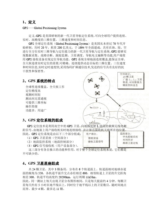
1、定义GPS——Global Positioning System定义:GPS是美国研制的新一代卫星导航定位系统,可向全球用户提供连续、实时、高精度的三维位置,三维速度和时间信息。
GPS全球定位系统(Global Positioning System)是美国从本世纪70年代开始研制,历时20年,耗资200亿美元,于1994年全面建成,具有在海、陆、空进行全方位实时三维导航与定位能力的新一代卫星导航与定位系统。
GPS能够实现数据采集、故障诊断、跟踪监测、卫星调度、导航电文编辑等功能,用户端使用GPS接收设备实现定位导航功能。
GPS系统全球地面连续覆盖,能保证全球、全天候连续实时定位的需要;可精确、连续提供动态目标的三维位置、三位速度和时间信息,实时定时速度快;采用伪码扩频通信技术,发送的信号具有良好的抗干扰性和保密性。
2、GPS系统的特点全球性连续覆盖,全天候工作定位精度高观测时间短测站间无需通视可提供三维坐标操作简便功能多,用途广3、GPS定位系统的组成GPS定位技术是利用高空中的GPS卫星,向地面发射L波段的载频无线电测距信号,由地面上用户接收机实时地连续接收,并计算出接收机天线所在的位置。
因此,GPS定位系统是由以下三个部分组成:(1)GPS卫星星座(空间部分)(2)地面监控系统(地面控制部分)(3)GPS信号接收机(用户设备部分)。
这三部分有各自独立的功能和作用,对于整个全球定位系统来说,它们都是不可缺少的。
4、GPS卫星星座组成共24颗卫星,其中3颗备用,分布在6个轨道面上。
轨道面相对地球赤道面的倾角为550,各轨道平面升交点赤经相差600,相邻轨道上卫星的升交距角相差300。
轨道平均高度约20200km,运行周期11h58m。
因此,同一测站上每天出现卫星分布图形相同,只是每天提前约4分钟。
每颗卫星每天约有5小时在地平线以上,同时位于地平线以上的卫星数目,随时间地点而异,最少4颗,最多达11颗。
GPS中英翻译

Absolute Positioning 绝对定位Ambiguity 整周模糊度Antenna 天线Antenna-phase-center offset 天线相位中心补偿Baseline Vector 基线向量Broadcast Ephemeris 广播星历Carrier phase measurements 载波相位测量值control networks 控制网coordinate transformation 坐标变换Coordinated Universal Time 协调世界时cutoff angle 截至角cycle slip 周跳differential corrections 差分矫正Differential GPS 差分GPS Differential Positioning差分定位Dilution of Precision 精度因子double-differenced observation 双差观测值Dual-frequency GPS receiver 双频GPS接收机Ephemeris errors 星历误差Ephemeris Errors 星历误差epoch 历元Geodetic Survey 大地测量Geographic Information System地理信息系统Geometric Dilution of Precision 几何精度因子Global Navigation Satellite System 全球导航卫星系统GPS receiver GPS接收机GPS satellite constellation GPS卫星星座GPS signal structure GPS信号结构high precision positioning techniques 高精度定位技术Independent Baseline 独立基线Ionospheric Delay 电离层延迟Kinematic Positioning 动态定位Local Area Differential GPS局域差分GPS longitude,latitude and altitude 经度,纬度与大地高multipath effect 多路径影响Phase-Smoothed Pseudo-Range 相位平滑伪距Precise Ephemeris 精密星历propagation path 传播路径pseudo-range measurement 伪距测量值Real Time Kinematic 实时动态Reference Ellipsoid 参考椭球Relative Positioning 相对定位Satellite and receiver clock error 卫星与接收机钟差simultaneous loop closure 同步闭合环single-differenced observation 单差观测值single-frequency GPS receiver 单频GPS接收机static GPS surveying 静态GPS测量The electron density 电子密度the Geoid surface 大地水平面The Orthometric Height 正高Triple-Difference 三差Tropospheric Delay 对流层延迟Wide Area Differential GPS 广域差分GPS World Geodetic System 1984 WGS-84全球大地坐标系。
浅析GPS静态测量-RTK及CORS的基本原理
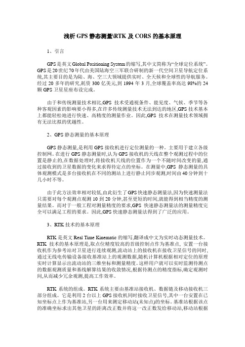
浅析GPS静态测量\RTK及CORS的基本原理1、引言GPS是英文Global Positioning System的缩写,其中文简称为“全球定位系统”。
GPS是20世纪70年代由美国陆海空三军联合研制的新一代空间卫星导航定位系统,其主要目的是为陆、海、空三大领域提供实时、全天候和全球性的导航服务。
经过20多年的研究,耗资300亿美元,到1994年3月,全球覆盖率高达98%的24颗GPS卫星星座布设完成。
由于和传统测量技术相比,GPS技术受通视条件、能见度、气候、季节等各种客观因素的影响要小得多,在许多传统测量技术无法到达的地区,GPS技术基本上都能轻松地进行快速、高精度的测量作业。
因此,GPS技术在测量技术领域拥有无法比拟的优越性。
2、GPS静态测量的基本原理GPS静态测量,是利用GPS接收机进行定位测量的一种。
主要用于建立各级控制网。
在进行GPS静态测量时,认为GPS接收机的天线在整个观测过程中的位置是静止的,在数据处理时,将接收机天线的位置作为一个不随时间改变的量,通过接收到的卫星数据的变化来求得待定点的坐标。
在测量中,GPS静态测量的具体观测模式是多台接收机在不同的测站上进行静止同步观测,时间由40分钟到十几小时不等。
由于此方法效率相对较低,由此衍生了GPS快速静态测量法,因为快速测量法只需要对每个观测点观测10到20分钟,甚至更短的时间,就能得到相当精度的测量结果。
而对于一般工程对测量精度的要求,GPS快速静态测量法的测量精度完全可以满足工程的要求。
因此,GPS快速静态测量法得到了广泛的应用。
3、RTK技术的基本原理RTK是英文Real Time Kinematic的缩写,翻译成中文为实时动态测量技术。
RTK技术的基本原理是,取点位精度较高的首级控制点作为基准点, 安置一台接收机作为参考站对卫星进行连续观测,流动站上的接收机在接收卫星信号的同时,通过无线电传输设备接收基准站上的观测数据,随机计算机根据相对定位的原理实时计算显示出流动站的三维坐标和测量精度。
GPS详解

1.什么是全球定位系统(GPS)全球定位系统(Global Positioning System - GPS)是美国从本世纪70年代开始研制,历时20年,耗资200亿美元,于1994年全面建成,具有在海、陆、空进行全方位实时三维导航与定位能力的新一代卫星导航与定位系统。
经近10年我国测绘等部门的使用表明,GPS以全天候、高精度、自动化、高效益等显著特点,赢得广大测绘工作者的信赖,并成功地应用于大地测量、工程测量、航空摄影测量、运载工具导航和管制、地壳运动监测、工程变形监测、资源勘察、地球动力学等多种学科,从而给测绘领域带来一场深刻的技术革命。
全球定位系统(Global Positioning System,缩写GPS)是美国第二代卫星导航系统。
是在子午仪卫星导航系统的基础上发展起来的,它采纳了子午仪系统的成功经验。
和子午仪系统一样,全球定位系统由空间部分、地面监控部分和用户接收机三大部分组成。
按目前的方案,全球定位系统的空间部分使用24颗高度约2.02万千米的卫星组成卫星星座。
21+3颗卫星均为近圆形轨道,运行周期约为11小时58分,分布在六个轨道面上(每轨道面四颗),轨道倾角为55度。
卫星的分布使得在全球的任何地方,任何时间都可观测到四颗以上的卫星,并能保持良好定位解算精度的几何图形(DOP)。
这就提供了在时间上连续的全球导航能力。
地面监控部分包括四个监控间、一个上行注入站和一个主控站。
监控站设有GPS用户接收机、原子钟、收集当地气象数据的传感器和进行数据初步处理的计算机。
监控站的主要任务是取得卫星观测数据并将这些数据传送至主控站。
主控站设在范登堡空军基地。
它对地面监控部实行全面控制。
主控站主要任务是收集各监控站对GPS卫星的全部观测数据,利用这些数据计算每颗GPS卫星的轨道和卫星钟改正值。
上行注入站也设在范登堡空军基地。
它的任务主要是在每颗卫星运行至上空时把这类导航数据及主控站的指令注入到卫星。
浅谈GPS与信息信号的关系
浅谈GPS与信息信号的关系GPS 是英文Global Positioning System(全球定位系统)的简称,而其中文简称为“球位系”。
GPS是20世纪70年代由美国陆海空三军联合研制的新一代空间卫星导航定位系统。
在军事任务中,GPS是大幅提升军力的重要手段。
GPS具有的通用数据、通用格栅、通用时间,使它在军事作战的各个方面都起着重要的作用。
继军用之后,GPS又向民用方向发展了许多,比如说在导航、物流、勘探,里程统计等等方面都用很大的作用。
现今全球有四大GPS系统分别是:美国GPS、欧盟“伽利略”、俄罗斯“格洛纳斯”和中国北斗卫星导航系统(BeiDou (COMPASS)Navigation Satellite System)。
既然GPS是一种卫星通讯的形式,那么信号和信息技术在GPS技术方面就会起到很大的作用了——为了实现导航定位,首先,我们需要GPS接收机负责定位,给出经纬度,其次,我们也需要一套精确的地图,精确是指误差至少小于10米,当然了,一台计算机(或PDA)是必不可少的,最重要的是要有一个可以做路径规划的自导航软件。
其技术包括计算机、GIS、地图、全球卫星定位系统、路径规划。
所以,信息与信号在GPS有很大的应用,比如说我们需要一个很好的软件就必须涉及到信息的领域。
接下来我就就信号方面来谈一谈GPS的原理,GPS导航系统的基本原理是测量出已知位置的卫星到用户接收机之间的距离,然后综合多颗卫星的数据就可知道接收机的具体位置。
要达到这一目的,卫星的位置可以根据星载时钟所记录的时间在卫星星历中查出。
而用户到卫星的距离则通过纪录卫星信号传播到用户所经历的时间,再将其乘以光速得到(由于大气层电离层的干扰,这一距离并不是用户与卫星之间的真实距离,而是伪距(PR):当GPS卫星正常工作时,会不断地用1和0二进制码元组成的伪随机码(简称伪码)发射导航电文。
GPS 系统使用的伪码一共有两种,分别是民用的C/A码和军用的P(Y)码。
GPS专业英语词汇翻译_交通运输英语词汇

acquisition time: 初始定位时间active leg: 激活航线adapter: 转接器、拾音器、接合器airborne: 空运的、空降的、机载的、通过无线电传播的alkaline: 碱性的、碱性almanac: 历书、概略星历anti-spoofing: 反电子欺骗artwork: 工艺、工艺图atomic clock: 原子钟auto-controlling: 自动控制avionics: 航空电子工学;电子设备azimuth: 方位角、方位(从当前位置到目的地的方向)beacon: 信标bearing: 方向,方位(从当前位置到目的地的方向)bug: 故障、缺陷、干扰、雷达位置测定器、窃听器built-in: 内置的、嵌入的cellular: 单元的、格网的、蜂窝的、网眼的cinderella: 水晶鞋、灰姑娘coarse acquisition code(c/a): 粗捕获码cold start: 冷启动connector: 接头、插头、转接器constellation: 星座control segment: 控制部分converter: 转换器、交换器、换能器、变频管、变频器、转换反应堆coordinate: 坐标co-pilot: 飞机副驾驶cost-effective: 成本低,收效大的course: 路线、路程、航线course deviation indicator (cdi): 航线偏航指示course made good (cmg): 从起点到当前位置的方位course over ground (cog): 对地航向course to steer(cts): 到目的地的最佳行驶方向crosstrack error (xte/xtk): 偏航de-emphasis: 去矫、去加重definition: 清晰度diagonal: 对角线、斜的、对角线的distinguishability: 分辨率dropping resistors: 减压电阻器、将压电阻器datum: 基准desired track (dtk): 期望航线(从起点到终点的路线) differential gps (dgps): 差分gpsdilution of precision (dop): 精度衰减因子elevation: 海拔、标高、高度、仰角、垂直切面、正观图enroute: 在航线上、航线飞行ephemeris: 星历estimated position error (epe): 估计位置误差estimated time enroute (ete): 估计在途时间(已当前速度计算) estimated time of arrival (eta): 估计到达时间front-loading data cartridges: 前载数据卡geodesy: 大地测量学global positioning system(gps): 全球定位系统glonass: 俄国全球定位系统goto: 从当前位置到另一航路点的航线greenwich mean time: 格林威治时间grid: 格网坐标heading: 航向headphone: 戴在头上的收话器、双耳式耳机headset amplifier: 头戴式放大器high-contrast: 高对比度intercom: 内部通信联络系统、联络用对讲电话装置intersection: 空域交界interface option (i/o): 界面接口选项initialization: 初始化invert route: 航线反转jack: 插座、插孔keypad: 键盘、按键kinematic: 动态的l1 frequency: gps信号频率之一(1575.42 mhz)l2 frequency: gps信号频率之一(1227.6 mhz)latitude: 纬度、纬线leg (route): 航段,航线的一段liquid crystal display (lcd): 液晶显示器local area augmentation system (laas): 局域增强系统localizer: 定位器、定位发射机、定位信标longitude: 经度、经线long range radio direction finding system (loran): 罗兰导航系统magnetic north: 磁北magnetic variation: 磁偏角map display: 地图显示meter: 米mount: 安装、支架、装配、管脚、固定件multiplexing receiver: 多路复用接收机multipath: 多路径nautical mile: 海里 (1海里=1.852米).navigation: 导航navigation message: 导航电文navigation satellite timing and ranging(navstar) global positioning system: gps系统的全称national marine electronics association (nmea): (美国)国家航海电子协会nmea 0183: gps接收机和其他航海电子产品的导航数据输出格式north-up display: gps屏幕显示真北向上observatory: 观象台、天文台offset: 偏移量omnidirectional: 全向的、无定向的orientation: 方位、方向、定位、倾向性、向东性panel: 仪表盘、面板panel-mount: 配电盘装配parallel channel receiver: 并行通道接收机p-code: p码photocell: 光电管、光电池、光电元件pinpoint: 极精确的、准确定位、准确测定、针尖pixel: 象素position: 位置position fix: 定位position format: 位置格式power-on: 接通电源pre-amplifier: 前置放大器prime meridian: 本初子午线pseudo-random noise code: 伪随机噪声码pseudorange: 伪距rack: 齿条、支架、座、导轨resolution: 分辨率route: 航线rs-232: 数据通信串口协议radio technical commission for maritime services (rtcm): 航海无线电技术委员会,差分信号格式selective availability (sa): 选择可用性sidetone: 侧音source: 信号源、辐射体space segment: 空间部分speed over ground (sog): 对地航速specifcation: 详述、说明书、规格、规范、特性split comm: 分瓣通信squelch:静噪音、静噪电路、静噪抑制电路statute mile: 英里(1英里=1,609米)straight line navigation: 直线导航strobe: 闸门、起滤波作用、选通脉冲、读取脉冲tracback - 按航迹返航track-up display - 航向向上显示track (trk): 航向transceiver:步话机、收发两用机transponder: 雷达应答机、(卫星通讯的)转发器、脉冲转发机transducer: 渔探用探头、传感器triangulation: 三角测量true north: 真北turn (trn): 现时航向和目的地之间的夹角two-way: 双向的、双路的、双通的universal time coordinated (utc): 世界协调时间universal transverse mercator (utm): 通用横轴墨卡托投影u.s.c.g.: 美国海岸警卫队user interface: 用户自定义界面user segment: 用户部分velocity made good (vmg): 沿计划航线上的航速viewing angles: 视角waypoint: 航路点wide area augmentation system (waas): 广域差分系统world geodetic system - 1984(wgs-84): 1984年世界大地坐标系windshield: 防风玻璃、防风罩y-code: 加密的p码yoke: 架、座、轭、磁轭、磁头组、偏转线圈。
- 1、下载文档前请自行甄别文档内容的完整性,平台不提供额外的编辑、内容补充、找答案等附加服务。
- 2、"仅部分预览"的文档,不可在线预览部分如存在完整性等问题,可反馈申请退款(可完整预览的文档不适用该条件!)。
- 3、如文档侵犯您的权益,请联系客服反馈,我们会尽快为您处理(人工客服工作时间:9:00-18:30)。
全球定位系统(GPS)全球定位系统(GPS) 是世界范围的无线电导航系统,它由24颗卫星及其地面站组成. 利用这些GPS 的" 人造卫星 " 为计算基准点来计算位置可以准确到几米的精度. 事实上, 先进 GPS测量方式,精度可以达到一公分或更小! 在某种意义上说,它就像是给地球上的每平方米的表面以独特的地址.全球定位系统接收机已经使用微型集成电路,因而越来越便宜. 而且,几乎每个人都可以使用这技术. 现在GPS正在走进汽车、船舶、飞机、建筑设备、电影制作工具等各个领域,甚至笔记本电脑.GPS很快成为像电话一样成为基本的工具. 事实上,在戴维特林布尔,我们认为它可能成为一种普遍的通用工具.这里是GPS如何工作的五个步骤:1.全球定位系统以由卫星形成的“三角形”为基础.2.由“三角形”利用全球定位系统接收机利用无线电波的传播时间来测量距离.3.为了测量传播时间,GPS需要有非常精确的时间.4.随着距离,你需要知道卫星究竟是在太空的什么地方. 高轨道和认真监控是关键.5.最后你必须对任何延误的信号进行改正,因为它穿过大气层由此可见,整个方法就是利用GPS卫星在太空作为参考点在地球上进行定位. 没错,通过非常、非常准确地测量距离,我们可以用三颗卫星组成的" 三角形"确定我们在地球上任何地方的位置.暂时不考虑我们如何测量接收距离的措施. 我们等会再讨论. 首先解释如何利用空间的三颗卫星来精确测量到地面的距离.大几何观念:假如测量我们到卫星的距离,发现它是11,000英里.知道我们距离那颗卫星的距离是11,000海里,我们可以假设我们在整个宇宙中的一个领域表面,它是以11,000公里为半径的围绕着这个卫星的表面.下面,我们又测量距离,找到了第二颗卫星,它在1.2万英里外.这告诉我们,我们不仅在11,000英里的表面还在以第二颗卫星为圆心,半径12,000英里的圆表面. 或者换句话说,我们在这两个表面的交叉处如果我们再测量从第三颗卫星,并发现是13000英里,那我们缩小了位置,更进一步小了,得到13000英里圆穿越的圈子与前两个圆相切的那两点.由三颗卫星,我们可以将空间缩小到两点。
决定哪一个点才是我们真正的位置,我们可以进行第四次测量. 但通常其中的一个是荒谬的答案(或是从地球太远,或有可能在移动速度),不用测量我们就可以排除. 第四次测量是有另一个原因的,不过不想现在说,我们等会再解释.下面我们再看看系统如何测量到卫星的距离。
1. 三角形位置由计算到卫星的距离(范围)得到.在数学上我们需要四个卫星的距离来确定确切位置. 如果我们能排除荒谬的答案或使用其他手段,三个距离就是足够的了。
需要另外一个距离的原因是由于有待于讨论的技术原因. 我们看到,在上一节定位测量距离计算,至少需要3个卫星.但是怎么测量一个的左右浮动空间的距离呢? 我们通常是计算从卫星发出的信号到到达我们的接收机所经过的时间.2.数学概念从某种意义上说,这可归结为"速度乘以时间"我们高中的数学问题. 记得以前一句话:"如果一辆汽车以每小时60英里的速度行驶两小时,这是多远的路程呢?"速度(60英里/小时)×时间(2小时)=距离(120英里)对于GPS测量我们的无线电信号,它和光速一样每秒约相当于186000英里。
问题就是测量传播时间.测定时间的问题是微妙的. 首先,时间通常持续的很短, 如果卫星是在头顶的正上方,信号的整个旅行时间将只有0.06秒. 因此,我们需要一些真正准确的钟表. 接着我们就讨论这个问题.但我们假如有了精确的时钟,如何测量旅行时间呢? 为了说明这一点,我们就用一个有趣比喻: 相信有办法让这两个卫星接收机,在中午十二时正同时开始播放 " 星旗国歌 "乐曲. 如果声音能从空间(这当然是荒谬的)传来,我们就可以听到两个版本的星旗国歌,一个来自接收来,一个来自卫星。
这两个版本将脱节. 来自卫星的版本将推迟一点,因为有超过11,000英里的传播时间.如果我们希望知道到底延迟了多少,我们就可以开始延迟接收的卫星的信号,直至他们落入完美同步.我们推后接收机的播放时间和卫星信号的传播时间是一样的. 所以只乘当时的光速, 那么卫星到我们的距离就可以知道了.取代播放“星旗国歌”的方式,GPS使用了一种叫做 " 伪随机密码 "的技术 --可能比播放星旗国歌的方式更容易。
.随机密码伪随机码(中华人民共和国所示)是全球定位系统的一个基本组成部分. 实际上只是一个非常复杂的数字代码,换句话说,是一个很复杂的关于“开”和“关”两个脉冲排列顺序。
由于信号太复杂,它几乎像是随机电机噪音. 因此名称 " 伪随机. "复杂是有好几个原因:第一,有利于复杂的格局,保证了接收不到不小心同步信号等. 形态非常复杂,信号的偏离有完全相同的形状的可能性极低.由于每颗卫星都有自己独特的伪随机代码如此复杂又保证了不会不小心接收另一颗卫星的信号. 所以很难利用卫星在同一频率上互相干扰. 而且更使敌对势力的干扰系统难有作为. 事实上伪随机密码的方式由国防部在该系统控制使用的.但还有一个使用复杂的伪随机编码的原因,一个重要的原因是 GPS的经济化. 使用的密码“信息论”可能是为了“健全”全球定位系统的信号. 那也是为什么不用大卫星全球定位系统接收器接收GPS信号的原因.如果测量无线电信号传播时间是全球定位系统的关键,那么,我们阻止手表倒不如缝补好,因为如果他们的时间推迟仅千分之第一秒,以光的速度,即转化为近200英里的误差! 在卫星方面,时间几乎是完美的,因为他们使用令人难以置信的原子钟 .但对于我们这里地面接收是怎样的呢?记住,卫星和接收机都必须能够使用精确的同步伪随机密码,使系统工作.如果我们必须用原子钟(成本从$50K上升$100K)GPS技术将有缺陷, 因为没有人能够负担得起高昂的成本.幸运的是设计师找到了全球定位系统的小把戏,让我们可以在接收机上使用相对低一点准确度的时钟. 这一招是全球定位系统的关键因素之一,作为补充手段它意味着基本上每一个全球定位系统接收机都可以使用原子的精确时钟.给出完美的时间的秘诀是额外的卫星测量.没错,如果三次测量可以确定三维空间中的一点,那么四次不完美测量同样可以这样做,通过测量抵消额外时间。
如果我们接收机的时钟是完美的,那么我们所有的卫星测量距离将有单一交叉点(这是我们的立场). 但钟表不完美,为完成核对的第四次测量不会和前三次有交叉. 因此接收机的计算机表示“我测量有差别. 我肯定没有和世界时一致。
”因为任何时候抵消来自协调世界时的差别都将会影响我们的所有测量,接收机找一个校正因子,可以扣除其所有测量时间,会使他们都在单一交叉点.这项改正使时钟与世界协调时一致! 还可以随手获得正确的原子时. 一旦该纠正它适用于所有其他国家,我们便得到了测量的精确定位.这一原则的一个后果是任何像样的全球定位系统接收机,需要有至少四个渠道,以便它能同时测量四次与伪随机密码的稳如磐石脉冲时间同步,这额外测量使我们的时间与世界协调是时一致,我们已经得到了所需要的一切去测量一颗空间的卫星的距离. 我们的三角工作不仅要知道距离,我们还需要确切知道那里有卫星.至此,我们早就补习了假定我们知道我们能够做的是把GPS卫星作为参考点. 但我们知道怎样准确的知道他们在何处? 毕竟他们已经在11,000英里左右空间漂浮着.这实际上11,000英里的高度是有利的。
在这种情况下,在这一高度的大气是非常清爽的. 这即是说,它将按照简单的数学轨道运行.空军根据GPS 总体规划,将GPS卫星注入到每一个非常准确的轨道,现场所有的全球定位系统接收机方案与电脑接通,每时每刻告诉他们每颗卫星在天上的位置.基本的轨道相当精确,只是为了某些事情的完美,那就使GPS卫星时刻由国防部监控. 他们使用非常准确的雷达检查卫星的确切高度、位置和速度.他们一直在查核的误差是 " 星历表误差 " ,因为它影响卫星的轨道或 "星历表. " 这些错误是由来自月球和太阳引力和太阳辐射对卫星的压力.很小的误差通常非常小,但如果你想要他们非常精确就必须考虑这个问题.获得的信息进行一旦国防部测量卫星的确切位置,他们传达这方面的资料,卫星本身回升. 然后将这个新的卫星改正信号,它的时间位置信息传播回去.GPS信号,不仅仅是伪随机代码的时间目的. 它也包含了星历表资料与信息及导航.有完善的时间和卫星的准确位置,我们就会被认为妳愿意尽完美位置计算. 但也有一定的麻烦.到现在,我们早就对GPS非常明显的计算作了数学处理,好像这些事都是发生在真空中. 但在现实世界中有很多事情可以发生在一个全球定位系统的信号,从而使自己的寿命低于数学计算上的完美.为使该系统发挥最大的作用,全球定位系统接收机好需要考虑到多种可能出现的误差. 这里是如何来对付他们的方法.首先,我们这一节使用的一个基本假设在事实上情况并非如此. 我们早就说了你到卫星的距离可以通过计算出卫星的信号的传播时间乘以光速. 但光速只是在真空中才是恒定的.作为GPS信号穿过的带电粒子电离层然后通过水的水汽对流层放慢一点,这造成了错误,就像不准确的钟表.有两种方法来减少这种误差. 可以预料的一件事是在典型的一天的典型延迟. 这叫做典型因为它是有帮助的,当然就是典型大气条件很少.另一种处理这些大气引起误差的方法是比较两种不同的信号的相对速度. 这种 " 双频率 " 计量可能是很复杂的,只有先进的接收机才能满足.全球定位系统信号的麻烦当它传到地上时并没有结束. 由于本地的信号干扰,信号将会在到达我们的接收机前跳动。
这叫做多路径效应. 好的接收机利用先进的复杂信号拒绝接收技术减少这一问题.问题在于卫星即使是很复杂的卫星他们也会在系统中有一些小小的误差.他们使用的原子钟非常、非常准确,但它不是尽善尽美. 一分钟的差异可能发生,而这些传播时间转化为传播时间测量误差.卫星的位置,即使是时刻监视,但不能每一秒都不错过. 小小的位置变动或者" 星历表 " 潜行之间的误差可能在监测时发生.本节你将看到一个简单的概念,可以提高全球定位系统的精确度限制,几乎令人难以置信.全球定位系统是最准确的基于无线电的导航系统并不断发展. 由于高精度它有许多应用。
但人的天性对它有更多的要求!工程师提出了这样一种 " 差分全球定位系统, " 它是一种纠正GPS中各种缺陷的工作方法,将其精确度推至更远.差分全球定位系统测量工作取得了很好的应用,运动中的测量精度为两米,在静止状态下更好.这有着深刻的影响,由于准确的GPS成为一种重要的资源. 它与GPS系统变得不仅仅使飞机和轮船航行到世界各地. 它成为一种能在非常精确的范围下的普遍的定位测量系统,差分全球定位系统接收机涉及两个合作,一个是静态的,另一个是环绕进行巡回位置测量. 固定接收机是关键的. 它关系到所有的卫星测量了坚实的地方参考.这里介绍GPS如何工作记得全球定位系统接收器使用至少四个卫星的时间信号来完成一次定位. 每种信号时间将会有一些什么样的错误或延误取决于在到达我们的过程中遭遇的情况。