航海学补充题
船员考试题库-航海学(沿海航区500总吨及以上船舶二三副)
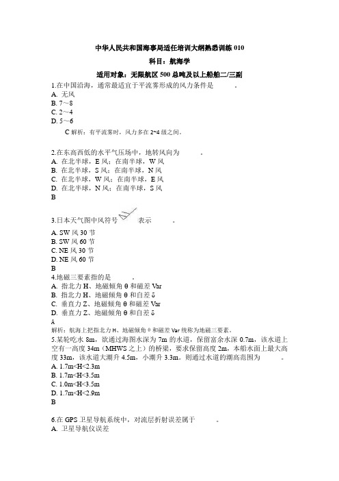
中华人民共和国海事局适任培训大纲熟悉训练010科目:航海学适用对象:无限航区500总吨及以上船舶二/三副1.在中国沿海,通常最适宜于平流雾形成的风力条件是______。
A. 无风B. 7~8C. 2~4D. 5~6C解析:有平流雾时,风力多在2~4级之间。
2.在东高西低的水平气压场中,地转风向为______。
A. 在北半球,E风;在南半球,W风B. 在北半球,S风;在南半球,N风C. 在北半球,W风;在南半球,E风D. 在北半球,N风;在南半球,S风B3.日本天气图中风符号表示______。
A. SW风30节B. SW风60节C. NE风30节D. NE风60节B4.地磁三要素指的是______。
A. 指北力H、地磁倾角θ和磁差VarB. 指北力H、地磁倾角θ和自差δC. 垂直力Z、地磁倾角θ和磁差VarD. 垂直力Z、地磁倾角θ和自差δA解析:航海上把指北力H、地磁倾角θ和磁差Var统称为地磁三要素。
5.某轮吃水8m,欲通过海图水深为7m的水道,保留富余水深0.7m,该水道上空有一高度34m(MHWS之上)的桥梁,要求保留高度2m,本船水面上最大高度33m,该水道大潮升4.5m,小潮升3.3m。
则通过水道的潮高范围为______。
A. 1.7m<H<2.3mB. 1.7m<H<3.5mC. 1.0m<H<3.5mD. 1.7m<H<2.9mB6.在GPS卫星导航系统中,对流层折射误差属于______。
A. 卫星导航仪误差B. 卫星误差C. 几何误差D. 信号传播误差D解析:信号传播误差包括电离层折射误差、对流层折射误差和多径效应等。
7.目前中版《航海通告》转载由IMO划分的NA V AREA第______海区的无线电航行警告。
A. IB. VC. XID. 全部C8.三天体定位,相邻两天体的方位差角趋近______最好。
A. 0°B. 90°C. 120°D. 180°C9.不正规半日潮港是指______。
航海学试题二十三
航海学试题⼆⼗三1. 地理坐标的基准线是:A. 经线、纬线B. ⾚道、经线C. 格林⼦午圈、纬圈D. ⾚道、格林⼦午线2. 航海学中,使⽤地球椭圆体为地球数学模型的场合是:①描述地球形状时②定义地理坐标时③制作墨卡托投影海图时④计算⼤圆航线时⑤制作简易墨卡托图⽹时A.①② B.②③ C.③④ D.③⑤3. 已知到达点纬度30°11'.8N,两地间纬差38°07'.8N,则起航点纬度为:A. 20°19'.6NB. 08°04'.0NC. 07°56'.0SD. 08°04'.0S4. 通过______的半个⼤圆称为天体垂直圈。
A. 天顶、天体和天底B. 天北极、天体和天南极C. 天顶、测者地理位置和天底D. 仰极、天体和俯极5. 以两极为起⽌点,过天体的半个⼤圆称为:A. 测者午圈B. 天体垂直圈C. 天体⾚纬圈D. 天体时圈6. 在同⼀张墨卡托海图上,设⾚道上图长1cm代表地⾯长度约为1 855m,则在30 纬度线上图长1cm约代表地⾯长度:A.1 855m B.1 843m C.1 606m D.2 141cm7. 罗经点⽅向NNW换算成圆周⽅向为:A. 292°.5B. 303°.75C. 326°.25D. 337°.58. 某船真航向240°,测得某物标真⽅位080°,则该物标的相对⽅位(舷⾓)为:A. 160°B. 220°C. 160°左D. 160°右9. 在《航海天⽂历》中查得世界时1200时的太阳格林时⾓是001°30′,则该⽇的时差约为:A.-6M00S B.+6M00S C.-1M0S D.+1M30S10. 某船陀罗航向140°,陀罗差2°E,测得某物标陀罗⽅位350°,则该物标舷⾓为:A. 210°B. 152°左C. 148°左D. 212°11. 船舶定线制⽂件要求船舶驾驶员根据船舶定线制的⼀般规定使⽤定线制,按照船舶定线制的⼀般原则进⾏定线。
航海学题库(含答案)
航海学大连海事大学1.1.1 地球形状·用大地球体描述地球形状,大地球体是大地水准面团城的球体.·常用的大地球体的近似体有两个:地球圆球体(用于简便的航海计算,如航迹计算,简易墨卡托海图绘制,大圆航向和航程计算);地球椭圆体(用于较精确的航海计算等,如定义地理坐标,墨卡托海图绘制)1.航海上为了简化计算,通常将地球当作:A.圆球体B.椭圆体C.椭球体D.不规则几何体2.航海上进行精度较高的计算时,通常将地球当作:A.圆球体B.椭圆体C.椭球体D.不规则几何体3.航海学中,使用地球椭圆体为地球数学模型的场合是:I.描述地球形状时;II.定义地理坐标时;III.制作墨卡托投影海图时;IV.计算大圆航线时;V,制作简易墨卡托图网时A.I、II B.II、III C.III、IV D.III、V4.航海学中,使用地球圆球体为地球数学模型的场合是:I.描述地球形状时;II.定义地理坐标时;III.制作墨卡托投影海图时;IV.计算大圆航线时;V.制作简易墨卡托图网时A.Ⅰ、ⅡB.Ⅱ、ⅢC.Ⅲ、ⅣD.Ⅳ、Ⅴ5.航海学中的地球形状是指:A.地球自然表面围成的几何体B.大地水准面围成的几何体C.地球圆球体D.以上都对6.航海学中的地球形状用描述。
A.地球自然表面围成的几何体B.大地球体C.地球椭圆体D.以上都对1.1.2 地理坐标1.1.2.1 地理经度和地理纬度的定义和度量方法.地理坐标包括地理经度和地理纬度,是建立在地球椭圆体基础之上.地理经度(Long.,λ:格林经线和某地经线所夹的赤道短弧或该短弧所对应的球面角或球心角.地理纬度(lat.,ϕ):地球椭圆子午线上某点的法线与赤道面的交角.7.地理经度以作为基准线的A.赤道. B.格林经线C.测者经线D.测者子午圈8.某地地理经度是格林子午线与该地子午线之间的A.赤道短弧B.赤道短弧所对应的球心角C.极角D.A.B.C都对9. 地理坐标的基准线是A.经线、纬线B.赤道、经线C.格林子午圈、纬圈D.赤道、格林子午线10.地理经度的度量方法是A.由格林子午线向东度量到该点子午线,度量范围0~180ºB.由格林子午线向西度量到该点子午线,度量范围0~180ºC.由格林子午线向东度量到该点子午线,度量范围0~360ºD.A或B11.地理经度的度量方法是A.由该点子午线向东或向西度量到格林子午线,度量范围0~180ºB.由该点子午线向东或向西度量到格林子午线,度量范围0~360ºC.由格林子午线向东或向西度量到该点子午线,度量范围0~180ºD .由格林子午线向东或向西度量到该点子午线,度量范围0~360º12.所谓“地埋纬度”是指A .地球上某点的法线与赤道面的交角B .地球上某点和地心连线与赤道面的交角C .地球椭圆子午线上某点和地心连线与赤道面的交角D .某点在地球椭圆子午线上的法线与赤道面的交角13.地理经度和地理纬度是建立在_____基础上的。
航海学题库(含答案)
1.1.1 地球形状常用的大地球体的近似体有两个:地球圆球体(用于简便的航海计算,如航迹计算,简易墨卡托海图绘制,大圆航向和航程计算);地球椭圆体(用于较精确的航海计算等,如定义地理坐标,墨卡托海图绘制)2.航海上进行精度较高的计算时,通常将地球当作:A.圆球体B.椭圆体C.椭球体D.不规则几何体3.航海学中,使用地球椭圆体为地球数学模型的场合是:I.描述地球形状时;II.定义地理坐标时;III.制作墨卡托投影海图时;IV.计算大圆航线时;V.制作简易墨卡托图网时A.I、II B.II、III C.III、IV D.III、V4.航海学中,使用地球圆球体为地球数学模型的场合是:I.描述地球形状时;II.定义地理坐标时;III.制作墨卡托投影海图时;IV.计算大圆航线时;V.制作简易墨卡托图网时A.Ⅰ、ⅡB.Ⅱ、ⅢC.Ⅲ、ⅣD.Ⅳ、Ⅴ5.航海学中的地球形状是指:A.地球自然表面围成的几何体B.大地水准面围成的几何体C.地球圆球体D.以上都对6.航海学中的地球形状用描述。
A.地球自然表面围成的几何体B.大地球体C.地球椭圆体D.以上都对8.某地地理经度是格林子午线与该地子午线之间的A.赤道短弧B.赤道短弧所对应的球心角C.极角D.A.B.C都对9.地理坐标的基准线是A.经线、纬线B.赤道、经线C.格林子午圈、纬圈D.赤道、格林子午线10.地理经度的度量方法是A.由格林子午线向东度量到该点子午线,度量范围0~180ºB.由格林子午线向西度量到该点子午线,度量范围0~180ºC.由格林子午线向东度量到该点子午线,度量范围0~360ºD.A或B12.所谓“地埋纬度”是指A.地球上某点的法线与赤道面的交角B.地球上某点和地心连线与赤道面的交角C.地球椭圆子午线上某点和地心连线与赤道面的交角D.某点在地球椭圆子午线上的法线与赤道面的交角13.地理经度和地理纬度是建立在_____基础上的。
航海学 (补充)练习题 题库
C、求实际航迹向
59. 已知标准罗经航向100°,自差 –1°,此时操舵罗经航向105°;通过与标准罗经航向 比对,得操舵罗经自差为: A.+4° B. +6° C.+6° D.-5° 60. 已知测者纬度等于 30°N, 3 月 21 日测得太阳真没罗方位等于 92°NW, 则罗经差为___。 A.+2° B.-2° C.+1° D.-1° 1、简述影响风压差的因素? 2、试述陆标两方位和两距离定位时,选择物标和观测顺序的要求?白天和夜间有何区别? 1、某船欲从(8°06'N,73°00'E)处航行到(12°10'N,51°00'E) ,问应驶计划航迹向是多少? 航程多少?
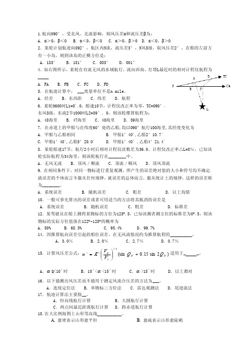
1.航向090°,受北风、北流影响,则风压差α和流压差β为: A. α>0,β<0 B. α<0,β<0 C. α>0,β>0 D. α<0,β>0 2.某轮计划航迹向092°,航区内N流,流压差3°,N风5级,取风压差2°,在船的左前方 有一小岛,则到该岛的正横方位是: A.183° _____ A. FA A.经差 B.FB C.FC D.FD C.纬差 D.航程 5.在航迹计算中, ___度量单位不是n mile。 B.东西距 6.某轮0600时L1=0'.0,船速10节,计程仪改正率为零,TC=090°, 东风3级,东流2节1000时L2=39′.0,则该轮推算航程为: A.48海里 B.47海里 C.40海里 D.39海里 7.在赤道上的甲船与在纬度60°处的乙船,均以090°航行100海里,其经度变化为 A. 甲船与乙船相同 C. 甲船1°40´,乙船3°20.0´ B. 甲船1°40´,乙船2°10.7´ D. 甲船1°40´ ,乙船4°21.4´ B.181° C.003° D.001° 4.如右图所示,某轮在有流无风的水域航行,流向西南,灯塔L最近时的相对计程仪航程为
航海概论期末考试试题及答案
航海概论期末考试试题及答案一、选择题(每题2分,共20分)1. 航海学中,下列哪个术语指的是船舶在海上航行时的导航方式?A. 航迹B. 航向C. 航线D. 航速2. 根据国际海事组织规定,船舶在海上航行时,应保持的最低安全速度是多少?A. 5节B. 10节C. 15节D. 20节3. 航海中使用的“六分仪”主要用于测量什么?A. 船速B. 船位C. 船高D. 船重4. 船舶在海上遇到风浪时,下列哪项操作是错误的?A. 调整航向B. 减速慢行C. 紧急转向D. 增加船员值班5. 海图上的“航标”通常用来指示什么?A. 航道B. 危险区域C. 港口D. 风向6. 船舶在航行时,如何确定自己的确切位置?A. 通过GPSB. 通过雷达C. 通过罗盘D. 通过海图7. 船舶在海上航行时,遇到紧急情况需要发出求救信号,应使用哪种设备?A. 无线电B. 卫星电话C. 声纳D. 灯光信号8. 船舶在航行时,如何避免与海底障碍物相撞?A. 通过声纳探测B. 通过目视C. 通过雷达D. 通过GPS9. 船舶在海上航行时,如何确定自己的航向?A. 通过罗盘B. 通过海图C. 通过GPSD. 通过卫星电话10. 船舶在海上航行时,如何计算到达目的地的时间?A. 通过航速和航程B. 通过海图和罗盘C. 通过GPS和卫星电话D. 通过雷达和声纳二、填空题(每空1分,共10分)11. 船舶在海上航行时,通常使用_________来确定航向。
12. 船舶在海上航行时,需要遵守的国际规则是_________。
13. 船舶在海上航行时,使用_________来测量船位。
14. 船舶在海上航行时,需要定期检查_________以确保航行安全。
15. 船舶在海上航行时,遇到紧急情况需要发出的国际求救信号是_________。
三、简答题(每题10分,共30分)16. 请简述船舶在海上航行时,如何进行航迹规划?17. 请简述船舶在海上航行时,如何进行航向调整?18. 请简述船舶在海上航行时,如何进行船位确定?四、论述题(每题15分,共30分)19. 论述船舶在海上航行时,如何进行风险评估与管理?20. 论述船舶在海上航行时,如何进行紧急情况的应对?五、案例分析题(共10分)21. 假设你是一名船长,你的船舶在海上遭遇了恶劣天气,你将如何指挥船舶安全航行?航海概论期末考试试题答案一、选择题1. B2. B3. B4. C5. A6. A7. A8. A9. A 10. A二、填空题11. 罗盘 12. 国际海上避碰规则 13. 六分仪 14. 船舶设备 15. SOS三、简答题16. 航迹规划是船舶航行前的一项重要工作,需要根据目的地、海图、气象信息、船舶性能等因素,合理规划航线,确保航行安全。
航海英语补充700题带答案
航海英语附加题[1]___A___20 targets can be tracked at one time.When maximum tracking capacity is reached,no further acquisitions(捕获) are possible.A.As many as B.So many as C.As much as D.As more as[2]___A___amplify charted detail and contain information needed for safe navigation.A.Admiralty Sailing Directions B.Admiralty List of LightsC.Admiralty List of Signals D.Admiralty Notices to Mariners[3]___D___are published for the correction of Admiralty Charts.A.Admiralty Sailing Directions B.Admiralty List of SignalsC.Mariner's Handbook D.Admiralty Notices to Mariners[4]___B___cargoes chargeable at the same rate,part of one ton shall be taken as one ton.A.At B.For C.On D.About[5]__D____chart 3994,positions read from this chart should be shifted 0.03 minutes Northward.A.To consideer B.To check C.To examine D.To agree with[6]__D____chart 3994,positions read from this chart should be shifted 0.03 minutes Northward.A.To consider B.To check C.To examine D.To agree with[7]__B____day,pilot flag should be displayed from main mast.A.From B.By C.On D.With[8]___A___get your engine ready before six tomorrow morning.A.Y ou’d better B.Y ou would better C.Y ou at least D.Y ou at most[9]__A____is a device used to measure atmospheric pressure.A.Barometer B.Thermometer C.Chronometer D.Speedometer[10]__A____is a rounded projection at the forward end of a ship which reduces water resistance,thus allowing an increase in speed when the ships is in ballast.A.Bulbous bow B.Ellipse bowC.Cyclical projection D.Gnomonic projection[11]__C____is an angle at which a cargo settles in the hold of a ship,between the horizontal and the slope made by a bulk cargo such as grain or iron ore.A.Angle of loll B.Angle of inclination C.Angle of repose D.Angle of list[12]__D____is not a process of weathering of the oil spilled in the sea water.A.Evaporation B.Dispersion C.Emulsification D.Drifting[13]___D___is one of four uprights comprising a cell in a containership into which a container fits exactly.These uprights hold the container in position.A.stanchion B.shore C.cellular double-bottom D.Ceil guide[14]__B____is the number of millimeters by which the mean draft changes when a ship passes from salt water to fresh water,or vice versa,whilst floating at the loaded draft.A.TPC B.The Fresh Water Allowance C.Parallel sinking of the ship D.UKC [15]__A____is the process by which the position of the vessel at any moment is found by applyingthe last well-determined position to the run that has been made since,using for this purpose the ship's course and the distance being those indicated by log.A.Dead reckoning B.Dead weightC.Dead slow ahead D.Dead slow astern[16]___A___is the speed of a vessel allowing time for effective action to be taken under prevailing circumstances and conditions to avoid a collision and to be stopped within an appropriate distance.A.Safe speed B.Economic speedC.Proper speed D.Navigation speed[17]___B___is used for heaving up and slacking away the anchor and chain.A.A mooring winch B.A windlassC.A deck crane D.A lifeboat engine[18]__C____means the curve on the earth's surface which cuts all the meridians at the same angle.A.Great Circle B.Position Line C.Rhumb line D.True Bearing[19]___B___of a radar is governed by the horizontal beam width of the scanner which depends to a great extent on its physical size.A.Range discrimination B.Bearing discriminationC.Echo discrimination D.Target discrimination[20]___C___of the following conditions will cause a vessel's bottom to be subjected to tension stresses.A.Concentration of weight aftB.Concentration of weight forwardC.Concentration of weight amidshipsD.Concentration of weight at both ends of the vessel[21]___A___of the following need NOT be entered in the Official Logbook?A.The testing of the internal combustion engine driven emergency generators at least once each month the vessel is navigated.B.The testing of storage batteries for emergency lighting and power systems once each 6 months the vessel is navigated.C.The actual draft when the vessel arrives in salt water after departing a portD.The testing of the line-throwing appliance once every 3 months[22]___D___port anchor,one shackle in water.A.Throw B.Heave in C.Cut off D.Let go[23]__A____published in England amplify charted detail and contain information needed for safe navigation.A.Admiralty Sailing Directions B.Admiralty List of LightsC.Admiralty List of Signals D.Admiralty Notices to Mariners[24]___C___refers to the angle between true north and the heading line of the vessel.A.True position B.True meridian C.True course D.True bearing[25]___A___the abstracts of deck logbook covering the said accident.A.Attached herewith are B.Attached is herewithC.Attached are hereby D.Hereby are attached[26]___A___Two degree on starboard.A.What rudder B.How heading C.Are you on your course D.How answer [27]__B____water is the water to keep the ship’s stability.A.Bilge B.Ballast C.Slop D.Sanitary[28]__A____will reduce the visibility.A.dust B.sea water C.land sand D.wind[29]___B___Y okohama,We'll also call at some other Japanese ports.A.Beside B.Besides C.Except D.Excepting[30]“Full speed ahead”and “Full speed astern”are___D___given by the officers or the pilots.A.sailing orders B.speed ordersC.wheel orders D.telegraph orders[31]12HOURS STORM W ARNING V ALID FROM 1103990700 UTC.From this phrase,the warning is expected to be valid from___A___.A.0700 UTC MAR 11,1999 B.0700 UTC NOV 03,1999C.0700 UTC,1103 UTC D.11,39,07 UTC[32]A block that can be opened at the hook or shackle end to receive a bight of the line is a__D____.A.bight block B.gin block C.heel block D.snatch block[33]A bowline is used to___B___.A.join lines of equal size B.form a temporary eye (loop) at the end of a lineC.be a stopper D.keep a line from fraying[34]A buoy having red and green horizontal bands would have a light characteristic of___B___.A.group occulting B.composite group flashing C.Morse letter A D.quick flashing [35]A buoy marking a wreck will show a(n)__A____.A.white light FL (2) and a topmark of 2 black spheresB.occulting green light and may be letteredC.yellow light and will be numberedD.continuous quick white light and may be numbered[36]A cardinal mark showing an uninterrupted quick-flashing white light indicates the deepest water in the area is on the__A____.A.north side of the mark B.west side of the markC.east side of the mark D.south side of the mark[37]A certificated lifeboatman assigned to command the lifeboat must__C____.A.be the first individual to board the craft B.drain the hydraulic pressure before lowering the craft C.have a list of the persons assigned to the lifeboat D.All of the above [38]A chain stripper is used to__A____.A.prevent chain from clinging to the wildcatB.clean the marine debris from the chainC.flake chain from a boat's chain lockerD.clean chain prior to an x-ray inspection[39]A channel is stated as having a controlling depth of 38 feet.Which statement is TRUE?---C-- A.At least 80% of the channel is cleared to the charted depth.B.At least 50% of the channel is cleared to the charted depth.C.100% of the channel depth is clear to 38 feet.D.The sides of the channel conform to at least 50% of the controlling depth.[40]A chart has extensive corrections to be made to it.When these are made and the chart is again printed,the chart issue is a___B___.A.first edition B.new edition C.revised edition D.reprint[41]A chart with a natural scale of 1:160,000 is classified as a___B___.A.sailing chart B.general chart C.coast chart D.harbor chart[42]A check rope is__C____.A.a safety line attached to a man working over the sideB.used to measure water depthC.used to slow the headway of a bargeD.used to measure the overhead height of a bridge[43]A chock is a___B___.A.deck fitting used to secure mooring lines B.casting fitted at the side of a weatherdeck,used as a fairleadC.sharp block of wood used to support hygroscopic cargo D.smoke pipe for the galley stove[44]A cloud sequence of cirrus,cirrostratus,and altostratus clouds followed by rain usually signifies the approach of a(n)___C___.A.occluded front B.stationary front C.warm front D.cold front[45]A compass card without north-seeking capability that is used for relative bearings is a(n)___B___.A.bearing circle B.pelorus C.bearing bar D.alidade[46]A correction for augmentation is included in the Nautical Almanac corrections for___B___.A.the Sun B.the MoonC.V enus D.None of the above[47]A crew member has suffered frostbite to the toes of the right foot.Which is NOT an acceptable first aid measure?---A---A.Rub the toes briskly.B.Elevate the foot slightly.C.Rewarm rapidly.D.Give aspirin or other medication for pain if necessary.[48]A cyclone in its final stage of development is called a(n)___C___.A.tornado B.anticyclone C.occluded cyclone or occluded front D.polar cyclone [49]A deck fitting,used to secure line or wire rope,consisting of a single body with two protruding horns,is called a___D___.A.bitt B.bollard C.capstan D.cleat[50]A DECK,SPACE,AREA,ETC.,NOT PERMITTED TO BE ENTERED FOR SAFETY REASONS defines___A___.A.Restricted area B.Closed areaC.Prohibited placed D.Forbidden place[51]A DECK,SPACE,AREA,ETC.,NOT PERMITTED TO BE ENTERED FOR SAFETY REASONS defines__A____.A.Restricted area B.Closed areaC.Prohibited place D.Forbidden place[52]A design modification of an anchor chain which prevents kinking is the___B___.A.detachable link B.stud linkC.Kenter link D.connecting link[53]A Doppler log in the bottom return mode indicates the___D___.A.velocity of the current B.bottom characteristicsC.depth of the water D.speed over the ground[54]A Doppler speed log indicates speed over ground__B____.A.at all times B.in the bottom return modeC.in the volume reverberation mode D.only when there is no current[55]A fire has broken out on the stern of your vessel.Y ou should maneuver your vessel so the wind___B___.A.blows the fire back toward the vessel B.comes over the bow C.comes over the stern D.comes over either beam[56]A fire is discovered in the forepeak of a vessel at sea.The wind is from ahead at 35 knots.Y ou should___B___.A.remain on course and hold speedB.change course and put the stern to the windC.change course to put the wind on either beam and increase speedD.remain on course but slack the speed[57]A fire starts on your vessel while refueling.Y ou should FIRST___B___.A.stop the ventilation B.sound the general alarmC.determine the source of the fire D.attempt to extinguish the fire[58]A fireman’s outfit shall consist of___D___.I.Protective clothing I I. a VHF setIII.Boots and gloves of electrically non-conducting material IV.An electric safety lamp (hand lantern) V.An axeA.I,II,III,IV B.I,II,IV,V C.II,III,IV,V D.I,III,IV,V[59]A foam-type portable fire extinguisher would be most useful in combating a fire in___B___.A.solid materials such as wood or bales of fiber B.flammable liquids C.a piece of electrical equipment D.combustible metallic solids[60]A frontal thunderstorm is caused by___C___.A.pronounced local heatingB.wind being pushed up a mountainC.a warm air mass rising over a cold air massD.an increased lapse rate caused by advection of warm surface air[61]A galley grease fire on the stove may be extinguished using___C___.A.water B.foam C.the range hood extinguishing system D.fire dampers[62]A generally circular low pressure area is called a(n)___A___.A.cyclone B.anticyclone C.cold front D.occluded front[63]A green pillar light-buoy,Fl(2) 5s,is to be substituted for the red conical light-buoy close S.W.of the stranded wreck.The above sentence mainly refers to___A___.A.a red buoy is to be replaced by a green buoyB.a green buoy is to be replaced by a red buoyC.either a red buoy or a green buoy is to be replacedD.neither a red buy nor a green buoy is to be replaced[64]A GROUP OF CREW MEMBERS TRAINED FOR FIGHTING FLOODING IN THE VESSEL are known as___D___.A.Fire party B.Deck cadetsC.Research team D.Damage control team[65]A hurricane moving northeast out of the Gulf passes west of your position.Y ou could expect all of the following EXCEPT__D____.A.higher than normal swells B.high winds C.winds veering from south,through west,to northwest D.light showers[66]A hygrometer is a device used for determining___D___.A.the absolute temperature B.atmospheric pressureC.wind velocity D.relative humidity[67]A journal kept by the officer of the watch in which day to day happenings are recorded regarding the deck department is the___B___.A.cargo record book B.deck rough logC.bell book D.Official Logbook[68]A large navigational buoy (LNB) is painted___A___.A.redB.yellowC.with red and white vertical stripesD.with a distinct color and pattern unique to each buoy[69]A life line must be connected to the life raft__D____.A.at the bow B.at the stern C.in the middle D.all around[70]A line connecting all possible positions of your vessel at any given time is a___D___.A.longitude line B.isogonic linesC.latitude line D.line of position[71]A load line of a ship is assigned by the___D___.A.Minerals Management ServiceB.Department of EnergyC.Corps of EngineersD.A recognized classification society approved[72]A lookout can leave his station___C___.A.at the end of the watchB.at any timeC.only when properly relievedD.15 minutes before the end of the watch[73]A mark or place at which a vessel comes under obligatory entry,transit,or escort procedure is known as___B___.A.Way point B.Receiving point C.Reporting point D.Closest Point[74]A mark or place at which a vessel comes under obligatory entry,transit,or escort procedure is know as__B____.A.Way point B.Receiving point C.Reporting point D.Closest Point[75]A microbarograph is a precision instrument that provides a___B___.A.charted record of atmospheric temperature over timeB.charted record of atmospheric pressure over timeC.graphic record of combustible gases measured in an atmosphereD.graphic record of vapor pressure from a flammable/combustible liquid[76]A pattern according to which vessels and / or aircraft may conduct a co-ordinated search is a___C___.A.Research pattern B.Research modeC.Search pattern D.Search and rescue mode[77]A person who sees someone fall overboard should first___A___.A.call for help and keep the individual in sight B.run to the radio room to send an emergency messageC.immediately jump in the water to assist the individual D.go to the bridge to report captain[78]A position that is obtained by applying estimated current and wind to your vessel's course and speed is a(n)___B___.A.dead reckoning position B.estimated positionC.fix D.None of the above[79]A protective suit which reduces the body heat-loss of a person wearing it in cold water is called__C____.A.water suit B.diving suit C.immersion suit D.swimming suit[80]A qualified deck officer should be___A___the watch.A.in charge of B.arranged C.decided to D.the depth of[81]A radar set produces radio waves and then gives them out in the space by means of its__B____.A.height of waves B.antenna C.high frequency D.radio X-ray[82]A radio medical advice service__B____ships of all nationalities and no charge is made for this service.A.is available to B.is available forC.are available to D.are available for[83]A relative bearing is always measured from___D___.A.true north B.magnetic northC.the vessel's beam D.the vessel's head[84]A ROUND THROUGH THE VESSEL CARRIED OUT BY A CREW MEMBER OF THE WA TCH A T CERTAIN INTERV ALS SO THA T AN OUTBREAK OF FIRE MAY BE PROMPTLY DETECTED defines___A___.A.Fire patrol B.Fire control C.Smoke detection D.Fire drill[85]A safe pilot transfer operation relies on greatly the following except__B____.A.lighting at night time B.the number of the crewmembersC.lifebuoy with self-igniting light D.VHF communication with bridge[86]A sea with height 2.5 –4.0m is termed as___C___according to the sea and swell scale.A.slight sea B.Moderate sea C.Rough sea D.High sea[87]A security level,for which appropriate additional protective security measures shall be maintained for a period of time as a result of heightened risk of a security incident is defined as___B___.A.Security level 1 B.Security level 2C.Security level 3 D.Security level 4[88]A series of brief showers accompanied by strong,shifting winds may occur along or some distance ahead of a(n)___D___.A.upper front aloft B.cyclone C.occluded front D.cold front[89]A set of interior steps on a ship leading up to a deck from below is known as___A___.A.a companion way B.tween-decksC.stairs D.Any of the above are acceptable[90]A sheave is a__A____.A.grooved wheel in a block B.line to hold a lifeboat next to the embarkation deck C.partial load of grain D.seaman's knife[91]A shipper of cargo aboard your vessel offers a letter of indemnity for the cargo.This is done in order to obtain a(n)___A___.A.clean Bill of Lading B.order Bill of LadingC.straight Bill of Lading D.through Bill of Lading[92]A single line of position combined with a dead-reckoning position results in a(n)___C___.A.running fix B.fixC.estimated position D.assumed position[93]A solution to overcome tripping defects is an arrangement of special plates on either side of the flukes,designed to set them in the correct tripping position.These special plates are called___D___.A.trippers B.stocks C.stabilizers D.palms[94]A spring line leads__A____.A.fore and aft from the ship's side B.to the dock at a right angle to the vesselC.through the bull nose or chock at the bow D.through the chock at the stern[95]A stay is___A___.A.standing rigging B.a downhaul C.a halyard D.a jib[96]A storm is forecast for the area where your vessel is moored.For its safety you should put__C____.A.more slack in the mooring lines B.a strain on the mooring linesC.chafing gear on the mooring lines D.grease on the mooring lines[97]A synthetic mooring line is being heaved on a capstan.There is moderate strain on the line.The line begins to slip.Which of the following should be done?①Stop the capstan and take extra turns.②Have more than one seaman keep a substantial strain on the line and continue heaving easy.--A--A.①only B.②onlyC.Both ①and ②D.Neither ①nor ②[98]A tanker is cargo ship constructed or__A____for the carriage in bulk liquid cargoes of an inflammable nature.A.adapted B.adopted C.damp D.dump[99]A tide is called diurnal when___A___.A.only one high and one low water occur during a lunar dayB.the high tide is higher and the low tide is lower than usualC.the high tide and low tide are exactly six hours apartD.two high tides occur during a lunar day[100]A true bearing of a charted object,when plotted on a chart,will establish a___B___.A.fix B.line of position C.relative bearing D.range[101]A tug would NOT assist a ship to steer if the tug is made up to the large vessel__C____.A.by a tow line ahead of the vessel B.forward on either bow of the vesselC.approximately amidships of the vessel D.on the vessel's quarter [102]A twin screw vessel,making headway with both engines turning ahead,will turn more readily to starboard if you__C____.A.reverse port engine,apply right rudderB.reverse port engine,rudder amidshipsC.reverse starboard engine,apply right rudderD.reverse starboard engine,rudder amidships[103]A twin-screw ship going ahead on the starboard screw only tends to move___B___.A.in a straight line B.to port C.from side to side D.to starboard[104]A vessel emitting harmful substances into the air or spilling oil into the sea is a___A___.A.Polluter B.Emitter C.Spiller D.Oiler[105]A vessel engaged in fishing shall not impede the passage of___C___following a traffic lane.(1).a power______driven vessel (2).a sailing vessel (3).any vessel (4).a vessel of less than 20 metres in lengthA.(1) B.(1) & (2) C.(3) D.(4)[106]A vessel moored with two anchors,sometimes,at an exposed roadstead to__D____.A.aid turning the shipB.obtain a fine bearingC.increase ship swings to wind or tideD.lighten the stress of anchor chains[107]A vessel proceeding along a narrow channel shall__C____.A.avoid crossing the channel at right anglesB.not overtake any vessels within the channelC.keep as near as safe and practicable to the limit of the channel on her starboard sideD.when nearing a bend in the channel,sound a long blast of the whistle[108]A vessel restricted in her ability to maneuver is one which___B___.A.through some exceptional circumstance is unable to maneuver as required by the RulesB.from the nature of her work is unable to maneuver as required by the RulesC.due to adverse weather conditions is unable to maneuver as required by the RulesD.has lost steering and is unable to maneuver[109]A vessel trawling would display___C___.A.a black ball B.a basketC.a double cone,point to point D.none of the above[110]A VESSEL,OTHER THAN A RESCUE UNIT,DESIGNA TED TO CO-ORDINA TESURFACE SEARCH AND RESCUE OPERA TION WITHIN A SPECIFIED AREA is known as___B___.A.salving vessel B.Co-ordinator surface searchC.MERSAR D.the vessel being salved[111]A vessel's position should be plotted using bearings of___A___.A.fixed objects on shore B.buoys at a distanceC.buoys close by D.All of the above[112]A vessel's quarter is that section which is___D___.A.abeam B.dead asternC.just aft of the bow D.on either side of the stern[113]A warm air mass is characterized by___A___.A.stability B.instabilityC.gusty winds D.good visibility[114]A weather forecast states that the wind will commence backing.In the Northern Hemisphere(北半球),this would indicate that it will___D___.A.shift in a clockwise manner B.decrease in velocityC.continue blowing from the same direction D.shift in a counterclockwise manner[115]A wind vane on a moving vessel shows__C____.A.dead reckoning wind direction B.true wind directionC.relative wind direction D.estimated wind direction[116]Aboard a survival craft,ether can be used to__A____.A.start the engine in cold weather B.aid in helping personnel breatheC.prime the sprinkler system D.prime the air supply[117]According to the customs of this port,the work of opening and closing hatch covers is done by___C___.A.the ship's officers B.the foreman from the shore C.the ship's hands D.the tally man [118]Admiralty Notices to Mariners are published__B____.A.every day B.every week C.every month D.every year[119]Admiralty Notices to Mariners,containing important information for the mariners and enabling them to keep their charts and books corrected for the latest information,are issued daily and published in__A____.A.Weekly Editions B.Quarterly EditionsC.Annual Editions D.Monthly Editions[120]Admiralty Sailing Directions published in England are kept up to date by__C____.A.corrections B.publications C.supplements D.alterations[121]After a cold front passes,the barometric pressure___C___.A.drops,and the temperature drops B.drops,and thetemperature risesC.rises,and the temperature drops D.rises,and the temperature rises[122]After abandoning a vessel,water that is consumed within the first 24 hours will___A___.A.pass through the body with little absorbed by the system B.help to prevent fatigue C.help to prevent seasickness D.quench thirst for only 2 hours[123]After casting off moorings at a mooring buoy in calm weather,you should___B___.A.go full ahead on the engine(s)B.back away a few lengths to clear the buoy and then go ahead on the enginesC.go half ahead on the engines and put the rudder hard rightD.go half ahead on the engines and pass upstream of the buoy[124]AFTER DROPPING THE PILOT means___B___.A.After boarding the pilot B.After the pilot leaving the shipC.After the pilot going on board D.After taking the pilot[125]After each reading of an oxygen indicator,the instrument should be purged with___B___.A.CO2 B.fresh air C.the tested compartment's air D.water[126]Aircraft made forced___B___near position 23 o 32'N,110 o 13'E.A.striking B.landing C.grounding D.stranding[127]All accidents and damage to ship,equipment or personnel,must be__B____in the vessel deck log.A.entered into B.entered C.entered with D.entered in[128]All dunnage planks and mats must be sent on board___A___commencement of loading.A.prior to B.during C.in the period of D.afterwards[129]All echo-sounders can measure the___B___.A.actual depth of waterB.actual depth of water below keelC.average depth from waterline to hard bottomD.average depth of water to soft bottom[130]All electrical appliances aboard a vessel should be grounded to___B___.A.prevent them from falling when the vessel rollsB.protect personnel from electrical shockC.increase their operating efficiencyD.prevent unauthorized personnel from operating them[131]All events relating to navigation,such as ship's position,speed and details of the weather,are recorded in___A___.A.Logbook B.Bell BookC.Oil Record Book D.Compass Error Book[132]All of the following are engaged in fishing EXCEPT___B___.A.A vessel trawling B.A vessel trollingC.A vessel setting nets D.A vessel tending lines[133]All of the following records are usually maintained by the watch-standing officers aboard a vessel EXCEPT the__B____.A.deck logbook B.official logbookC.compass record book D.chronometer error book[134]ALL PASSENGERS OF DECK NO. 2 ARE REQUESTED TO FOLLOW THE CREW MEMBERS WHO WILL ESCORT YOU TO YOUR ASSEMBLY STA TIONS.From this sentence you can concluded that the vessel is in___B___.A.immediate danger to collide with another vessel B.a situation in which more passengers will embark on board C.berth and ready to disembark her passengers D.distress[135]All portable fire extinguishers must be capable of being___A___.A.carried by hand to a fire B.carried or rolled to a fireC.recharged in the field D.used on class 'B' fires[136]All straight lines represent great circle tracks on a chart based on a(n)___D___.A.Mercator projection B.polyconic projectionC.orthographic projection D.gnomonic projection[137]All the cargo holds must be___D___cleaned out______meet the requirement of the cargo surveyor.A.such/that B.so/that C.such/to D.so/as to[138]All the crewmembers shall be at the station as required by the muster list when in fire-fighting drill___A___minutes after hearing the alarm,and the duty engineer shall be able to make the fire pumps available with______minutes.A.2/5 B.2/3 C.3/2 D.2/2[139]All the holds to be loaded with grain must be swept__D____commencement of loading.A.cleanly/during B.clear/meanwhile C.clean/between D.clean/prior to [140]All vessel personnel should be familiar with the survival craft's___A___.A.boarding and operating procedures B.maintenance schedule C.navigational systems D.fuel consumption rates[141]All VHF marine band radios operate in the simplex mode,which means that___A___.A.only one person may talk at a time B.only two persons may talk at the same timeC.the radio only transmits D.the radio only receives[142]Allow me to put___D___some evidence for your further consideration.A.up B.on C.into D.forward[143]Altocumulus clouds are defined as___B___.A.high clouds B.middle cloudsC.low clouds D.vertical development clouds[144]An accident came__C____my mind when I saw the broken case.。
航海学补充
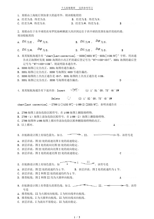
1.某船由上海航行到加拿大的温哥华,则该船航程的A .经差为E ,纬差为S 。
B .经差为E ,纬差为N 。
C .经差为W ,纬差为N 。
D .经差为W ,纬差为S 。
B 2.某船由位于东半球的直布罗陀海峡横渡大西洋到达位于西半球的美国东海岸的纽约港, 则该船航程的A .λD 为E , ϕD 为N 。
B .λD 为W , ϕD 为N 。
C .λD 为W , ϕD 为S 。
D .λD 为E , ϕD 为S 。
B3.某英版航海通告有“chart[Last correction].—3850[4633/97]—3851[4436/97]”字样,用该通告改正海图时发现3850海图的小改正栏的最后登记号为“97-4438-4547”,3851海图的最后登记号为“97-4403-4436”,则说明除本通告外,A .3850海图已完全改正,3851海图有通告漏改。
B .3851海图已完全改正,3850号海图仅4633号通告漏改。
C .3850海图的上次改正通告是4547,3851海图的上次改正通告是4436。
D .3851海图已完全改正,3850号海图有通告漏改。
D 4.某英版航海通告有下述内容: Insert(1) 1°51ˊ0N ,78°46ˊ0W Delete (2) 1°52ˊ0N ,78°45ˊ0W chart[Last correction].—2799(1)[4138/97]—1499(2)[2383/97]。
表明该通告在 A .2799海图上添加危险沉船符号,在1499海图上删除障碍物。
B .2799(1)海图上添加危险沉船符号,在1499(2)海图上删除障碍物。
C .2799海图和1499海图上都应作添加危险沉船和删除障碍物的改正。
D .以上都对。
A 5.在航路设计图上有绿色箭矢,如I 、、II 、等,该符号是A .表层洋流,图II 处的流速比图I 处的流速稳定。
航海学题库
航海学题库一、单选题1.航海上为了简化计算,通常将地球当作:A.圆球体B.椭圆体C.椭球体D.不规则几何体2.航海学中的地球形状是指:A.地球自然表面围成的几何体B.大地水准面围成的几何体C.地球圆球体D.以上都对3.地理经度以作为基准线的A.赤道. B.格林经线C.测者经线D.测者子午圈4. 中版海图图式“”或“”表示_________A.干出礁B.适淹礁C.危险暗礁D.非危险暗礁5.地理坐标的基准线是A.经线、纬线B.赤道、经线C.格林子午圈、纬圈D.赤道、格林子午线6.地理经度的度量方法是A.由格林子午线向东度量到该点子午线,度量范围0~180oB.由格林子午线向西度量到该点子午线,度量范围0~180oC.由格林子午线向东度量到该点子午线,度量范围0~360oD.A或B7.地理经度和地理纬度是建立在_____基础上的。
A.地球圆球体B.地球椭圆体C.地球椭球体D.球面直角坐8.地理纬度是某地子午线的_____与赤道面的交角。
A.半径B.切线C.法线D.铅垂线9.某点地理纬度的度量方法是A.自赤道向南或向北度量到该点等纬圈,度量范围0~180oB.自赤道向南或向北度量到该点等纬圈,度量范围0~90oC.自该点等纬圈向南或向北度量到赤道,度量范围0~180oD.自该点等纬圈向南或向北度量到赤道,度量范围0~90o10.地理经度和地理纬度的度量范围分别是A.0~90o、0~90oB.0~180o、0~180oC.0~90o、0~180oD.0~180o、0~90o11.纬度是以______作为基准线计量的A.赤道B.等纬圈C.格林经线D.测者经线12.下列关于经差、纬差的说法中,正确的是______ A.经差最大为180oB.纬差最大为90oC.由东半球航行至西半球,经差一定是东D.A.B都对13.下列关于经差、纬差的说法中,正确的是A.船舶由东半球航行至西半球,经差一定是东B.船舶由西半球航行至东半球,经差一定是西C.船舶由南半球航行至北半球,纬差—定是北D.A、B、C都对14.下列关于经差、纬差的说法中,正确的是_______ A.船舶由东半球航行至西半球,经差不一定是东B.船舶由北半球航行至南半球,纬差不一定是南C.船舶由南半球航行至北半球,纬差不一定是北D .A 、B 、C 都错15.陀罗差随下列哪些因素的变化而变化?A .航向B .方位C .时间D .航速和纬度16.磁北与罗北之间的夹角为:A .磁差B .自差C .罗经差D .陀罗差17.磁差随_______而变化A .地区与船磁B .地区与吃水C .地区与时间D .装载与吃水18.磁罗经的自差是____________A .真北至罗北的夹角B .磁北至罗北的夹角C .真北至磁北的夹角D .罗北至船首线的夹角19.磁罗经自差是_________A .磁北与罗北的夹角B .罗经差减去磁差C .磁方位减去罗方位D .以上三者都对20.磁罗经自差主要随的改变而变化。
航海英语补充题带答案版(真题)
【单选1】All oil spills must be reported to the ______.A.MOC ministration of communicationB.MSA OF CHINAC. local fire departmentD. local police 【单选2】Many of the lights on this coast are placed so high as to be frequently obscured by ______.A.coverB.showerC.towerD.power【单选3】The collision bulkhead is located ______.A.on the bridge deckB.at the stern of the shipC.as the first watertight bulkhead aheadD.between the passenger and cargo areas【单选4】The charts sold are of ______.A.the current edition and incorporate the last Notices to Mariners correctionB.brand-new one with up to date correction and clean writingC.newly edition with up to date correction and in reasonable pricesD.the current edition and incorporate the latest Notices to Mariners correction at the time of sale【单选5】______ is not contained in the NM Weekly.A.Amendments to Admiralty List of Radio SignalsB.Supplement to Guide to Port EntryC.Amendments to Admiralty Sailing DirectionsD.Amendments to Admiralty List of Lights and Fog Signals【单选6】Which document will describe lifesaving equipment located aboard your vessel?A.Muster ListB.Certificate of InspectionC.Forecastle CardD.Clearance Papers限制通讯工作) 【单选7】While proceeding towards a distress site you hear the message PRU-DONCE(over the radiotelephone. Which action should you take?A.Advise the sender of your course,speed,position,and ETA at the distress sitee that frequency only for restricted working communicat ionsC.Shift your radio guard to the working frequency that will be indicated in the messageD.Resume base course and speed because the distress is terminated【单选8】Which statement about stowing spare hose is TRUE?A.Fold the hose so that the male coupling is about 4 feet from the female coupling,then roll it upB.Roll the hose starting at the female endC.Roll the hose starting at the male endD.Fold the hose into lengths about 6 feet long and then lash the folds together【单选9】What is the primary purpose for Digital Selective Calling (DSC)?A.DSC is to be used for transmitting and receiving distress alerts to and from other ships or coast radio stations via radioB.This aids SAR authorities in tracking a vessel's position by satelliteC.DSC provides reception of weather and navigational warnings plus search and rescue informationD.DSC provides low-cost,routine communications for the vessel operator【单选10】The fire-protected lifeboats are found ______.A.satisfiedB.being satisfiedC.satisfactoryD.to satisfy?【单选11】After jacking down your liftboat you have an unexpected list. You find that the only cause of this list must be a flooded leg. The list caused by a flooded leg means your vessel has a(n) ______.A.decrease in the GZ (righting arm)B.less chance of deck edge immersionC.negative GM (metacentric height)D.increase in the waterplane and the metacentric height【单选12】In practice,it is usual for the ship to be loaded ______ to improve the vessel's movement through the water.A.a balance between two sidesB.at the same draught between fore and aftC.a little deeper forwardD.a little deeper aft【单选13】What is NOT a form used by ice support services to disseminate information? 什么是未被冰原支持服务被用来传播信息的形式 A.Ice Bulletins B.Ice Outlooks C.Ice Analyses D.Ice Forecasts 【单选14】In order to pay out or slack a mooring line which is under strain,you should ______.A.stopper the lineB.surge the lineC.sluice the lineD.slip the line【单选15】Which radiotelephone signal indicates receipt of a distress message?A.SOS acknowledgedB.Romeo,romeo,romeoC.Mayday rogerD.Roger wilco【单选16】When fighting a fire in a space containing an IMO class 1 hazardous cargo, the most effective fire fighting procedure is to ______.e high-expansion foamB.activate the fixed CO2 firefighting systeme water from fire hoses or a sprinkler systemD.shut down the ventilation and exclude all air to smother the fire【单选17】In the Northern Hemisphere a wind is said to veer when the wind ______.A.changes direction violently and erraticallyB.changes direction counterclockwise,as from south to east,etc.C.remains constant in direction and speedD.changes direction clockwise,as from north to east,et c.【单选18】When using an ARPA,what should you consider in order to evaluate the information displayed?A.The target vessel's generated course and speed are based solely on radar inputsB.Navigational constraints may require a target vessel to change courseC.You cannot determine if a small target has been lost due to sea returnD.The trial maneuver feature will automatically determine a course that will clear all targets【单选19】The movement of water away from the shore or downstream is called a(n) ______.A.reversing currentB.ebb currentC.flood currentD.slack current【单选20】How many GMDSS radio operators are needed/required on board according to the provisions of the International Convention for the Safety of Life at Sea,1974?A.2 operatorsB.1 operatorC.4 operatorsD.3 operators【单选21】The ship's tanks most effective for trimming are the ______.A.settlersB.peaksC.domesticsD.deeps【单选22】First aid means ______.A.setting of broken bonesB.emergency treatment at the scene of the injuryC.medical treatment of accidentD.dosage of medications【单选23】An orange flag showing a black circle and square is a ______.A.signal indicating a course changeB.distress signalC.signal of asking to communicate with another vesselD.signal indicating danger【单选24】All electrical appliances aboard a vessel should be grounded to ______.A.prevent them from falling when the vessel rollsB.increase their operating efficiencyC.protect personnel from electrical shockD.prevent unauthorized personnel from operating them 【单选25】It would be possible that part of the cargo got ______ as great change in the weather during the voyage caused heavy ______ in the hold.A.dampness/sweaterB.wetness/dewC.damp/waterD.wet/condensation【单选26】Do you need to measure oxygen levels before entering an enclosed space?A.NoB.Yes, alwaysC.Yes, but not if you ventilate properly first for 24 hoursD.Not if you measure for toxic gases【单选27】When is a stand-on vessel FIRST allowed by the Rules to take action in order to avoid collision?A.When the give-way vessel is not taking appropriate action to avoid collisionB.When collision is imminentC.The stand-on vessel is never allowed to take actionD.When the two vessels are less than half a mile from each other【单选28】Which of the following is the most useful factor for predicting weather?A.The present reading of the barometerB.The difference in the barometric readings within the past 24 hoursC.The rate and direction of change of barometric readingsD.The previous reading of the barometerCommunications over relatively short distances can be made by visual or sound signals. Visual signals can be sent by using flags or an Aldis lamp. An Aldis lamp is an electric lamp used for flashing messages in Morse code. The traditional method of signaling from one ship to another is by using flags. There are different colored flags for each letter of the alphabet. There are also pennant-shaped flags for numbers, and a long pennant, known as an answering or code pennant. Three other flags, which are burgee-shaped, are known as substitutes. These show that the flat or pennant is being repeated. Besides standing for a letter of the alphabet, each flag, when hoisted along, has another meaning. For example, the 'W' flag also means: 'I require medical assistance'. Flags can also be hoisted in combinations of two, three or four. Siren, whistle, bell or other sound signals can be used in fog and similar circumstances when visual signals can not be seen.(1)An Aldis lamp is used for ______.A.sending flag signalsB.sending sound signalsC.transmitting Morse codeD.flashing flags(2)Burgee-shaped flags are used as substitutes to show ______.A.'I requiring medical assistance'B.'repeating'C.'answering'D.'code' pennant(3)Communications over relatively short distances may be made by ______.A.Morse CodeB.Either visual or sound signalsC.sound signalsD.visual signals(4)______ are used in fog and similar circumstances when visual signals can not be seen.A.SubstitutesB.The ship's siren, whistle or bellC.Visual signalsD.Pennant-shaped flagsThe official original data (S57 data) of the electronic nautical chart is usually supplied on CD-ROM or,in case of updates, via digital telephone or satellite communication system. This original data is also called electronic nautical chart (ENC).The chat database is organized in cells that cover the entire earth's surface without overlapping. The cells store all nautical chat objects as well as objects created only during the operation of the system, such as waypoints and leg lines, notes, positions of own ship and of other vessels, etc.The data in the System Electronic Nautical Chart (SENC) is generated from the original data of the ENC. The Enc has to be kept unaltered in order to be able to reconstruct the SENC data if this is unintentionally damaged or destroyed. In SENC, the chart data is stored in a proprietary file format designed by the ECDIS manufacturer for speed and reliability.The S57 data represents a specific kind of attributed vector data. The kind of data (object description with geometry and geographical position) requires an efficient kind of storage. For compactness and speed, vector data is the optimal solution in contrast to the voluminous raster data.(1)Which of the following is correct statement?A.ENC is the raw data of the Electronic Nautical Charts and it may be changed by ECDIS manufacturerfor speed and reliabilityB.The database of an Electronic Nautical Chart System is compacter and the speed of the system is faster if those use voluminous dataC.ENC is a kind of voluminous raster data while the SENC is a kind of vector dataD.SENC is the raw data of the Electronic Nautical Charts and it may be changed by ECDIS manufacturer for speed and reliability(2)The passage implies ______.A.ENC is the raw data of the Electronic Nautical ChartB.The vector data is the optimal solution for ECDISC.SENC is the raw data of the Electronic Nautical ChartD.SENC may be designed with different representation purposes by different ECDIS manufacturers(3)Which of the following is Not Correct as to the ENC and SENC?A.The ENC can be reconstructed from the SENCB.The ENC is the raw data of the Electronic Nautical ChartC.The SENC is generated form the S-57D.The SENC can be reconstructed from the S-57①CD-ROM②Digital(4)The passage indicates that the update of the S-57 can be done via ______.telephone③Satellite communication system④Floppy DiskA.②③B.①~④C.②~④D.①~③【单选29】You are offloading garbage to another ship. Your records must identify that ship by name and show her ______.A.official numberB.MasterC.next port-of-callD.home port【单选30】The master shall be ______ the marine environment when taking collision-avoiding action.A.aware of B.in charge of C.interested in D.clear of【单选31】What is important to remember when using AIS for collision avoidance?A.AIS is not as accurate as ARPAB.AIS is not allowed to be used for collision avoidanceC.AIS may not give a complete picture of the traffic situationD.AIS is more accurate than ARPA【单选32】While proceeding to a distress site,you hear the words “Seelonce mayday” on the radiotelephone.Which action should you take? 指该频只供求救的船只,对答的救援机构或协助救援的船只使用,其他一般通讯暂停使用,直至宣布Seelonce feenee(Silence finit,法文:静默-完结)。
丙类三副版航海学新题库(含答案)
第1章基础知识1.航海上为了简化计算,通常将地球当作:A.圆球体B.椭圆体C.椭球体D.不规则几何体2.航海上进行精度较高的计算时,通常将地球当作:A.圆球体B.椭圆体C.椭球体D.不规则几何体3.航海学中,使用地球椭圆体为地球数学模型的场合是:I.描述地球形状时;II.定义地理坐标时;III.制作墨卡托投影海图时;IV.计算大圆航线时;V.制作简易墨卡托图网时A.I、II B.II、III C.III、IV D.III、V4.航海学中,使用地球圆球体为地球数学模型的场合是:I.描述地球形状时;II.定义地理坐标时;III.制作墨卡托投影海图时;IV.计算大圆航线时;V.制作简易墨卡托图网时A.Ⅰ、ⅡB.Ⅱ、ⅢC.Ⅲ、ⅣD.Ⅳ、Ⅴ5.航海学中的地球形状是指:A.地球自然表面围成的几何体B.大地水准面围成的几何体C.地球圆球体D.以上都对6.航海学中的地球形状用描述。
A.地球自然表面围成的几何体B.大地球体C.地球椭圆体D.以上都对1.1.2 地理坐标7.地理经度以作为基准线的A.赤道. B.格林经线C.测者经线D.测者子午圈8.某地地理经度是格林子午线与该地子午线之间的A.赤道短弧B.赤道短弧所对应的球心角C.极角D.A.B.C都对9.地理坐标的基准线是A.经线、纬线B.赤道、经线C.格林子午圈、纬圈D.赤道、格林子午线10.地理经度的度量方法是A.由格林子午线向东度量到该点子午线,度量范围0~180ºB.由格林子午线向西度量到该点子午线,度量范围0~180ºC.由格林子午线向东度量到该点子午线,度量范围0~360ºD.A或B11.地理经度的度量方法是A.由该点子午线向东或向西度量到格林子午线,度量范围0~180ºB.由该点子午线向东或向西度量到格林子午线,度量范围0~360ºC.由格林子午线向东或向西度量到该点子午线,度量范围0~180ºD.由格林子午线向东或向西度量到该点子午线,度量范围0~360º12.所谓“地埋纬度”是指A.地球上某点的法线与赤道面的交角B.地球上某点和地心连线与赤道面的交角C.地球椭圆子午线上某点和地心连线与赤道面的交角D.某点在地球椭圆子午线上的法线与赤道面的交角13.地理经度和地理纬度是建立在_____基础上的。
航海学补充题2
航海学补充复习题1.航海学中,使用地球椭圆体为地球数学模型的场合是:I .描述地球形状时;II .定义地理坐标时;III .制作墨卡托投影海图时﹔IV .计算大圆航线时﹔V .制作简易墨卡托图网时。
A .I 、IIB .II 、IIIC .III 、IVD .III 、V B2.航海学中,使用地球圆球体为地球数学模型的场合是:I .描述地球形状时;II .定义地理坐标时;III .制作墨卡托投影海图时﹔IV .计算大圆航线时﹔V .制作简易墨卡托图网时。
A .I 、IIB .II 、IIIC .III 、IVD .IV 、V D3.航海学中的地球形状是指:A .地球自然表面围成的几何体B .大地水准面围成的几何体C .地球圆球体D .以上都对 B4.航海学中的地球形状用________来描述。
A .地球自然表面围成的几何体B .大地球体C .地球椭圆体D .以上都对 B5.某船由33º30′N ,170ºW 起航,航行进入东半球,航程不超过1500海里,则该船航程的经差:A .向东B .向西C .向东、向西均可D .无法判断 B6.某船由33º30′N ,170ºE 起航,航行进入西半球,航程不超过1500海里,则该船航程的经差:A .向东B .向西C .向东、向西均可D .无法判断 A7.某船由上海航行到加拿大的温哥华,则该船航程的A .经差为E ,纬差为S 。
B .经差为E ,纬差为N 。
C .经差为W ,纬差为N 。
D .经差为W ,纬差为S 。
B8.某船由位于东半球的直布罗陀海峡横渡大西洋到达位于西半球的美国东海岸的纽约港, 则该船航程的A .λD 为E , ϕD 为N 。
B .λD 为W , ϕD 为N 。
C .λD 为W , ϕD 为S 。
D .λD 为E , ϕD 为S 。
B9.高度差是指:A .地球自然表面与地球椭圆体表面之差B .地球圆球体表面与大地水准面之差C .地球椭圆体表面与大地水准面之差D .大地球体表面与地球自然面之差 C10.高度差是指:A .大地球体表面与地球椭圆体表面之差B .地球圆球体表面与大地水准面之差C .大地水准面与地球椭圆体表面之差D .A 、C 都对 D11.某船2001年10月航行于英版海图的某个罗经花附近,罗经花上有下列数据:4º30′W 1991(9ˊE )。
航海学补充习题
1概括描绘了相应海区的总貌,比例尺小于 1:300万,图上主要表示海区范围、陆地地貌、 港湾、岛屿、海峡、水道、水深、海底地貌、灯塔和地名要素以及与海岸有一定距离危险物 的海图A .海区总图 B.航行图 C.港湾图 D.参考图 答案:A 2、 主要供研究海区形势及拟订航行计划使用的海图叫做:A .海区总图B.航行图C.港湾图D 参考图答案:A3、 比例尺介于1:10万至1:299万,图上主要表示与近海航行有关的航道、水深、陆地地貌 除岸边的浅滩和礁石可忽略不计外、应详细记载所有外海的航海危险物的海图叫做:A .海区总图 B.航行图 C.港湾图 D.参考图 答案:B 4、 主要供船舶在海上航行使用,也可供海洋调查、海洋研究参考使用的海图叫做:A .海区总图B.航行图C.港湾图D.参考图答案:B5、 比例尺一般大于1:10万,图上主要以表示港湾、 锚地为主,详细表示海岸的性质、 水深、水底航行障碍物、助航设备、港湾设施、锚地、港区界限和港务机关等要素,并附有潮信信 表的海图叫做:A .海区总图 B.航行图 C.港湾图 D.参考图 答案:C6、 主要供船舶进出港湾、避风锚地、停靠驻泊时使用,也可用于码头装卸作业和港湾施工 建设等方面工作的海图叫做:A .海区总图 B.航行图 C.港湾图 D.参考图 7、英版海图底质注记中,缩写“ G ”表示: A .粘土 B.淤泥 C.砾 D.贝壳10、英版海图底质注记中,缩写“ Wd ”表示:A.珊瑚B.贝C.海草 D 粘土11、 英版海图底质注记中,缩写“ fS.M.Sh ”表示: A 细沙,泥,贝的混合底质,其中主要成分为细沙B 细沙,泥,贝的混合底质,最上 层为细沙C 细沙,泥,贝的混合底质,其中主要成分为贝D 细沙,泥,贝的混合底质,最上层为贝答案:A12、 海图水面处所标水深注记 卩;表示:A.暗礁,最浅水深17米 B 干 出礁 C.特殊水深D.扫海测量水深 答案C13、 英版海图图式 ’表示何种礁石?A.暗礁B.干出礁C.适淹礁D.明礁14、暗礁旁边所标的数字表示: A.干出高度 B.高程 C.平均海面下的水深15、中版海图沉船图式“ '「二7 1”表示:D.部分船体露出深度基面的沉船16、中版海图沉船图式“ 、「'二表示:D.部分船体露出深度基面的沉船 17、中版海图图式答案:C 答案:C 答案:B答案DD.深度基准面以下的水深答案DA.深度不明的水下沉船B.干出沉船C.船体露出平 均大潮 高潮以 上的沉船答案CA.深度不明的水下沉船B.干出沉船C.船体露出平 均大潮 高潮以 上的沉船”表示:答案A21、 中版海图图式“”表示: A.已知深度的水下沉船B 干出沉船,数字为干出高度C. 船体露出平均大潮高潮面以上的沉船,数字为高程D. 部分船体露出深度基准面的沉船,数字为深度基准面以上的高度 答案A22、 英版海图上,明礁上所标的数字是由哪一海平面起算的? A.平均海面B.理论最低潮面C.天文最低潮面D.平均大潮高潮或平均高高潮或当地平均海面答案D23、英版海图图式“卞-尺―’ ”表示:24、英版海图图式 A.防波堤 B.桥C.多礁石地区D.大浪区25、英版海图图式“ 押”表示:A.深度不明的水下沉船B.干出沉船D.部分船体露出深度基准面的沉船才常w26、英版海图图式“匸产 ”表示:A.深度不明的水下沉船B.干出沉船D.部分船体露出深度基准面的沉船 27、英版海图图式“匸"邨”表示: A.深度不明的水下沉船 B.干出沉船C.船体露出平均大潮潮面以上的沉船 答案CC.船体露出平均大潮潮面以上的沉船 答案AC.船体露出平均大潮潮面以上的沉船D.部分船体露出深度基准面的沉船56 页---57 页A.防波堤B.桥C.大浪区D.多礁石地区 答案D18、中版海图图式“ El —I '' ” 表示: A.明礁 B.干出礁 19、中版海图图式“ A.珊瑚礁 B.明礁 C.暗礁 D.多礁石地区”表示:C.干出礁D.暗礁答案D 答案AA.深度不明的水下沉船出深度基准面的沉船B.干出沉礁 C 船体露出平均高潮以上的沉船 D.部分船体露答案BA.防波堤B.桥C.多礁石地区D.大浪区 答案C答案C答案B20、中版海图图式 表示:28. --------------------------------- 英版海图图式" 土 # ”表示 A .珊瑚礁B.明礁C.干出礁D.暗礁答案:A十1 7 ,29. 英版海图图式" 守*”表示A ,已知深度的水下沉船 B.干出沉船,数字为干出高度 C. 船体露出平均大潮高潮面以上的沉船,数字为高程D. 部分船体露出深度基准面的沉船,数字为深度基准面以上的高度 答案:A 30. 干出高度的起算面为: A •高程基准面B.深度基准面C.平均海面D.平均大潮高潮面答案:B31.中版海图图式“ ”表示:A •深度不明的井答案:C B.锚地 C.碍锚地 D.渔栅32.中版海图图式— * ”表示:A .灯桩 B.性质不明的障碍物 C.水下桩、柱 D.烟囱答案:C厂、件色 37. 中版海图图式“ J" ”表示:A.变色的海水B 变色的障碍物C 暗礁D 干出礁答案:AA .禁止捕鱼 B.渔网 C.鱼礁 D.渔栅 答案:C 、“〔三壬>2 7 ” 一 33. 中版海图图式" -- ”表示: A.已知最浅深度鱼礁 B.已知高度的鱼礁 C.带有编号的渔礁答案:A 34. 中版海图图式"一—— ----------- * ” 表示:A.已知最浅深度鱼礁B.已知高度的鱼礁C.带有编号的渔礁答案:A 35. 中版海图图式“ ”表示:A.已知最浅深度鱼礁B.已知高度的鱼礁C.带有编号的渔礁答案:B 36. 中版海图图式“丁 *匸”或“丁”表示: D.已知深度的渔网D.已知深度的渔网D.已知深度的渔网38.中版海图图式表示:A已知最浅深度的障碍物C高出平均大潮高潮面的障碍物答案:B 已知高度的障碍物经扫海或潜水员探测的障碍物39.中版海图图式“A已知最浅深度的障碍物C高出平均大潮高潮面的障碍物答案:A40.中版海图图式“A已知最浅深度的障碍物C高出平均大潮高潮面的障碍物答案:D”表示:已知高度的障碍物经扫海或潜水员探测的障碍物42•英版海图图式A沉船残骸及其它有碍抛锚和拖网的地区C渔栅答案:B44.英版海图图式“A已知最浅深度的障碍物C高出平均大潮高潮面的障碍物答案:A表示:B已知高度的障碍物D 经扫海或潜水员探测的障碍物45.英版海图图式“•一一A已知最浅深度的障碍物C高出平均大潮高潮面的障碍物答案:D ”表示:B已知高度的障碍物D 经扫海或潜水员探测的障碍物41.英版海图图式“表示A深度不明的井答案:CB锚地碍锚地D渔栅A禁止捕鱼答案:CB 渔网C鱼礁D渔栅43•英版海图图式I ------ 1|Obs tn |I______ i”表示:46.英版海图图式“!------------- :||___________ ■”表示:A渔栅答案:BB渔网C渔礁D贝类养殖场47.英版海图图式“A深度不明的障碍物■Foul”表示:B锚地C碍锚地D贝类养殖场表示:B 已知高度的障碍物经扫海或潜水员探测的障碍物表示:B深度不明的障碍物D贝类养殖场1口Jobs tn答案:C答案:C 答案:A 答案: D 1—■"11林区151.海图图式“ ■1 ”表示A 禁止船舶通航区域B 禁止抛锚的区域C 禁止捕捞的区域D 禁止抛锚及捕捞的区域答案:AA 禁止船舶通航区域 C 禁止捕捞的区域答案:A59页一60页54•下列选项哪些是电子海图显示和信息系统( ECDIS )必须具备的特征?I 海图内容与显示符合国际水道测量组织规定 S-52 ( Specifications for Chart ContentandDisplay Aspects of ECDIS ); II 系统功能符合国际海事组织制定的性能标准; 山 系统设备符合国际电工委员会的性能和测试标准(IEC61174); IV 海图内容与显示符合国际水道测量组织规定 S-61 ( Product Specifications for Raster Chart,RNC )A I 、II 、 IIIB II 、III 、IVC ID I 、II 、III 、IV 答案:A55•下列选项哪些是电子海图显示和信息系统( ECDIS )必须具备的特征?I 海图内容与显示符合国际水道测量组织规定 S-52 ( Specifications for Chart ContentandDisplay Aspects of ECDIS ); II 系统功能符合国际海事组织制定的性能标准; 山 系统设备符48.英版海图图式表示:A .灯桩 B.性质不明的障碍物 C.水下桩、柱 D.烟囱A.已知最浅深度鱼礁 C.带有编号的渔礁 D.已知深度的渔网50.英版海图图式 A 禁止捕鱼 B 渔网C 鱼礁D 海洋农场52.海图图式“ —Qi ”表示 A 有人看守等船B 无人看守等船C 灯塔答案:D D 蓝比53.海图图式jL-try Prohibit^表示B 禁止抛锚的区域 D 禁止抛锚及捕捞的区域49.英版海图图式 B.已知高度的鱼礁合国际电工委员会的性能和测试标准(IEC61174);IV由官方水道测量部门提供最新电子海图信息A I 、II 、B II 、III 、IV I、II、III 、IVIII 答案:D56.电子海图显示和信息系统( ___________ ECDIS )能够自动记录最近内所使用过的ENC 单元及其来源、版本、日期和改正历史,以及每隔一分钟的船位、航速、航向等。
航海英语补充习题集
航海英语补充习题1.----is a caing used for exhaust pipe from the engines.A.The funnelB.The messroomC.The galleyD.The satellite antennaA 烟囱是用做机器排气管的罩子。
2.-----is housed in a plastic dome for weather protection.A.The funnelB.The messroomC.The galleyD.The satellite anternnaD 卫星天线是包在塑料穹顶内以作天气保护。
3.-----is where delicious food is cooked.A.The funnelB.The messroomC.The galleyD.The satellite anternnaC厨房是美食烹饪之所。
4.------is where the crew eat their meals.A.The funnelB.The messroomC.The galleyD.The satellite anternnaB餐厅是船员用餐之地。
5.------is used to moor the ship to the seabed to keep it sationary.A.The bulbous bowB.The anchorC.The bow thrusterD.The propellerB锚是用将船泊于海床以保持静止。
6.--------is a roud-shaped underwater part in the front of the ship.The purpose is to cre-ate less friction with water so that the ship moves more easily.A.The bulbous bowB.The anchorC.The bow thrusterD.The propellerA球鼻首是船前部的水下圆形部分。
航海英语补充题154题
1]Which signal of the follwings is not provided with onboard lifeboat?答案:D.Self-igniting signalsA.Rocket parachute signalsB.Buoyant smoke signalsC.Hand flare signalsD.Self-igniting signals答案:D下列哪种信号在救生艇上不配备?自动点火信号[2]According to IMO regulations,______shall be posed outside lifeboat?答案 A.the retro-reflective tapesA.the retro-reflective tapesB.the reflective tapesC.the flashing bandsD.the anti-flashing bands答案:A根据国际海事组织规则,反光带应该安放在救生艇外面[3]Which one of the following is not required on survival crafts?答案D.lifebuoysA.Anti-seasickness medicineB.Immersion suitsC.axesD.lifebuoys答案:D下面哪一个在在救生筏上不需要---救生圈[4]Have the safety belts for _______been examined?答案C.totally enclosed lifeboatsA.total enclosed lifeboatsB.totally enclosing lifeboatsC.totally enclosed lifeboatsD.total encloseing lifeboats答案:C全封闭式救生艇的安全带已经检查过了吗?[5]The fire-protected lifeboats are found_____________.答案C.satisfactoryA.in satisfactorily conditionB.satisfactorilyC.satisfactoryD.satisfactored答案:C防火救生艇被发现是良好的[6]We test the water spray fire protection system of fire-protected lifeboats every 3 months,___the abandon ship drill.答案bined withbining withbined withbining tobined to答案:B我们每三个月测试防火救生艇的喷水防火系统,连同弃船训练。
新版航海学新题库(含答案)
第1章基础知识1.1 地球形状、地理坐标与大地坐标系1.1.1 地球形状用大地球体描述地球形状,大地球体是大地水准面围成的球体.常用的大地球体的近似体有两个:地球圆球体(用于简便的航海计算,如航迹计算,简易墨卡托海图绘制,大圆航向和航程计算);地球椭圆体(用于较精确的航海计算等,如定义地理坐标,墨卡托海图绘制)1.航海上为了简化计算,通常将地球当作:A.圆球体B.椭圆体C.椭球体D.不规则几何体2.航海上进行精度较高的计算时,通常将地球当作:A.圆球体B.椭圆体C.椭球体D.不规则几何体3.航海学中,使用地球椭圆体为地球数学模型的场合是:I.描述地球形状时;II.定义地理坐标时;III.制作墨卡托投影海图时;IV.计算大圆航线时;V.制作简易墨卡托图网时A.I、II B.II、III C.III、IV D.III、V4.航海学中,使用地球圆球体为地球数学模型的场合是:I.描述地球形状时;II.定义地理坐标时;III.制作墨卡托投影海图时;IV.计算大圆航线时;V.制作简易墨卡托图网时A.Ⅰ、ⅡB.Ⅱ、ⅢC.Ⅲ、ⅣD.Ⅳ、Ⅴ5.航海学中的地球形状是指:A.地球自然表面围成的几何体B.大地水准面围成的几何体C.地球圆球体D.以上都对6.航海学中的地球形状用描述。
A.地球自然表面围成的几何体B.大地球体C.地球椭圆体D.以上都对1.1.2 地理坐标1.1.2.1 地理经度和地理纬度的定义和度量方法地理坐标包括地理经度和地理纬度,是建立在地球椭圆体基础之上.地理经度(Long.,λ:格林经线和某地经线所夹的赤道短弧或该短弧所对应的球面角或球心角.地理纬度(lat.,ϕ):地球椭圆予午线上某点的法线与赤道面的交角.7.地理经度以作为基准线的A.赤道. B.格林经线C.测者经线D.测者子午圈8.某地地理经度是格林子午线与该地子午线之间的A.赤道短弧B.赤道短弧所对应的球心角C.极角D.A.B.C都对9.地理坐标的基准线是A.经线、纬线B.赤道、经线C.格林子午圈、纬圈D.赤道、格林子午线10.地理经度的度量方法是A.由格林子午线向东度量到该点子午线,度量范围0~180oB.由格林子午线向西度量到该点子午线,度量范围0~180oC.由格林子午线向东度量到该点子午线,度量范围0~360oD.A或B11.地理经度的度量方法是A .由该点子午线向东或向西度量到格林子午线,度量范围0~180oB .由该点子午线向东或向西度量到格林子午线,度量范围0~360oC .由格林子午线向东或向西度量到该点子午线,度量范围0~180oD .由格林子午线向东或向西度量到该点子午线,度量范围0~360o12.所谓“地埋纬度”是指A .地球上某点的法线与赤道面的交角B .地球上某点和地心连线与赤道面的交角C .地球椭圆子午线上某点和地心连线与赤道面的交角D .某点在地球椭圆子午线上的法线与赤道面的交角13.地理经度和地理纬度是建立在_____基础上的。
航海英语补充资料
航海英语补充习题1.____is casing used for exhaust pipe from the engines.A.The funnelB.The messroomC.The galleyD.The satellite antenna烟囱是用做机器排气管的罩子。
答案:A2.____is housed in a plastic dome for weather protection.A.The funnelB.The messroomC.The galleyD.The satellite antenna卫星天线是包在塑料穹顶内以做天气保护。
答案:D3.____is where delicious food is cooked.A.The funnelB.The messroomC.The galleyD.The satellite antenna厨房是美食烹饪之所。
答案:C4.____is where the crew eat their meals.A.The funnelB.The messroomC.The galleyD.The satellite antenna餐厅是船员用餐之地。
答案:B5.____is used to moor the ship to the seabed to keep it stationary.A.The bulbous bowB.The anchorC.The bow thrusterD.The propeller锚是用将船泊于海床以保持静止。
答案:B6.____is a round-shaped underwater part in the front of the ship.The purpose is to create less friction with water so that the ship moves more easily.A.The bulbous bowB.The anchorC.The bow thrusterD.The propeller球鼻首是船前部的水下圆形部分,目的是减小水的摩擦力以便船舶更容易运动。
- 1、下载文档前请自行甄别文档内容的完整性,平台不提供额外的编辑、内容补充、找答案等附加服务。
- 2、"仅部分预览"的文档,不可在线预览部分如存在完整性等问题,可反馈申请退款(可完整预览的文档不适用该条件!)。
- 3、如文档侵犯您的权益,请联系客服反馈,我们会尽快为您处理(人工客服工作时间:9:00-18:30)。
航海学补充题♣1.地球圆球体是大地球体的第一近似体。
在地球圆球体上,下列说法正确的是:A.纬度圈是一个圆B.子午圈是一个椭圆C.纬度圈是一个椭圆D.纬度圈和子午圈都是椭圆参考答案:A♣2.地球旋转椭圆体是大地球体的第二近似体。
在地球旋转椭圆体上,下列说法正确的是:A.子午圈是一个圆B.子午圈是一个椭圆C.纬度圈是一个椭圆D.纬度圈和子午圈都是椭圆参考答案:B3.我国长江口外有一花鸟山灯塔,关于该灯塔的地理位置,下列说法正确的是:A.该灯塔在任何一张海图上的地理经纬度值都是相同的B.该灯塔在任何一张海图上的地理经纬度值都是不相同的C.在两张比例尺大小不一样的海图上,该灯塔的地理经纬度值是不相同的D.在两张基于不同大地坐标系绘制的海图上,该灯塔的地理经纬度值可能不相同参考答案:D4.船舶在航行中更换海图时,如果两张海图是基于不同的大地坐标系绘制的,则下列做法正确的是:Ⅰ、若用船位的经纬度值换图时,则不必进行不同的大地坐标系之间的船位修正;Ⅱ、若用船位的经纬度值换图时,则需进行不同的大地坐标系之间的船位修正;Ⅲ、若以两张海图中共有的某一固定物标的方位和距离表示的船位换图时,则不必进行不同的大地坐标系之间的船位修正A.Ⅰ、ⅢB.Ⅱ、ⅢC.ⅢD.Ⅰ参考答案:B5.中版海图和航标表中灯标射程的含义是:A.晴天黑夜,测者的眼高为5m时能够看到灯标灯光的最大距离B.晴天黑夜,测者能够看到灯标灯光的最大距离C.晴天黑夜灯标灯光所能照射的最大距离D.晴天黑夜,气象能见度为10海里是,灯标灯光所能照射的最大距离参考答案:A6.关于中版海图和航标表中灯塔灯光的最大可见距离,下列说法正确的是:A.灯塔的最大可见距离等于该灯塔的地理能见距离B.灯塔的最大可见距离等于海图上所标的该灯塔的射程C.如灯塔有初显初隐,则该灯塔的最大可见距离等于该灯塔的地理能见距离D.对于弱光灯塔,其最大可见距离等于该灯塔的地理能见距离参考答案:C*7.要了解英版海图和灯标表中灯塔所标射程是否额定光力射程,可以查阅:A.航路指南B.灯标表中的“特殊说明”C.灯标表中主表的“备注栏”D.灯标表中主表的“射程栏”参考答案:B*8.英版海图某灯塔灯高81m,额定光力射程25M,已知测者眼高为25m,则能见度良好(10 nmile)时该灯塔的初显距离是:A.25 n mile B.29.3 n mileC.10 n mile D.无初显参考答案:D*9.在英版《灯标和雾号表》的“光达距离图”中,上边的横坐标是:A.光力强度B.额定光力射程C.不同能见度时的光力射程D.气象能见度参考答案:B*10.在英版《灯标和雾号表》的“光达距离图”中,下边的横坐标是:A.光力强度B.额定光力射程C.不同能见度时的光力射程D.气象能见度参考答案:A*11.在英版《灯标和雾号表》的“光达距离图”中,左边的纵坐标是:A.光力强度B.额定光力射程C.不同能见度时的光力射程D.气象能见度参考答案:C*12.根据英版《灯标和雾号表》中给出的某灯标的额定光力射程求取该灯标在不同气象能见度条件下灯光的光力射程时,可查阅:A.英版《灯标和雾号表》中的“光达距离图”B.英版《灯标和雾号表》中的“地理能见距离表”C.英版《灯标和雾号表》中的“气象能见距离表”D.英版《灯标和雾号表》中的“光力能见距离曲线图”参考答案:A13.船速是指:A.船舶在无风流情况下单位时间内航行的距离B.船舶在有风无流情况下单位时间内航行的距离C.船舶在无风有流情况下单位时间内航行的距离D.船舶在有风有流情况下单位时间内航行的距离参考答案:A14.主机航速是指:A.船舶在无风流情况下单位时间内航行的距离B.船舶在有风无流情况下单位时间内航行的距离C.船舶在无风有流情况下单位时间内航行的距离D.船舶在有风有流情况下单位时间内航行的距离参考答案:A15.有不同海区的两张墨卡托海图A图和B图。
A图的纬度范围30︒N–35︒N,基准比例尺1︰300000(基准纬度30︒N),B图的纬度范围35︒N–40︒N,基准比例尺1︰300000(基准纬度30︒N)。
设在A图上121︒E经度线和122︒E经度线的图上间距等于a,在B图上121︒E 经度线和122︒E经度线的图上间距等于b,则:A.a>b B.a<b C.a=b D.A和b的大小无法比较参考答案:C16.有不同海区的两张墨卡托海图A图和B图。
A图的纬度范围30︒N–35︒N,基准比例尺1︰300000(基准纬度30︒N),B图的纬度范围35︒N–40︒N,基准比例尺1︰300000(基准纬度35︒N)。
设在A图上121︒E经度线和122︒E经度线的图上间距等于a,在B图上121︒E经度线和122︒E经度线的图上间距等于b,则:A.a>b B.a<b C.a=b D.A和b的大小无法比较参考答案:A17.有不同海区的两张墨卡托海图A图和B图。
A图的纬度范围30︒N–35︒N,基准比例尺1︰300000(基准纬度30︒N),B图的纬度范围35︒N–40︒N,基准比例尺1︰500000(基准纬度30︒N)。
设在A图上121︒E经度线和122︒E经度线的图上间距等于a,在B图上121︒E 经度线和122︒E经度线的图上间距等于b,则:A.a>b B.a<b C.a=b D.A和b的大小无法比较参考答案:A18.海图的极限精度相当于图上0.1mm所表示的实地水平长度,如要求实地长度准确到5m,则地图比例尺不应小于:A.1︰500000 B.1︰100000 C.1︰50000 D.1︰5000参考答案:C♣19.关于高斯投影图上投影变形的说法正确的是:A.离轴子午线越近、纬度越低,变形越小B.离轴子午线越近、纬度越低,变形越大C.离轴子午线越近、纬度越高,变形越小D.离轴子午线越近、纬度越高,变形越大参考答案:C♣20.关于高斯投影图上投影变形的说法正确的是:A.离轴子午线越近、纬度越高,变形越小B.离轴子午线越远、纬度越低,变形越小C.离轴子午线越远、纬度越高,变形越大D.离轴子午线越近、纬度越高,变形越大参考答案:A*♣21.大圆海图在航海上的主要作用是:A.在大圆海图上量取大圆弧的航程B.在大圆海图上量取大圆航线的航向C.在大圆海图上量取大圆航线的分点坐标D.在大圆海图上量取某物标的大圆方位参考答案:C♣22.中版海图通常采用“1985国家高程基准面”作为高程基准面。
而“1985国家高程基准面”是指:A.1952年至1979黄海平均大潮高潮面B.1952年至1979年青岛附近海域平均海面C.1952年至1979年长江口附近海域平均海面D.1952年至1979年我国沿海平均海面参考答案:B♣23.关于在航海图书资料中标注深度基准面位置的方法,以下说法正确的是:A.以平均海面为基准来标注B.以潮高基准面为基准来标注C.以平均大潮高潮面为基准来标注D.以平均大潮低潮面为基准来标注参考答案:A♣24.关于深度基准面,以下说法正确的是:A.深度基准面是通过天文计算求得的B.深度基准面是平均大潮低潮面C.深度基准面是平均低低潮面D.深度基准面是根据长期验潮的数据所求得的理论上可能最低的潮面参考答案:D*♣25.关于高程基准面,以下说法正确的是:A.英版海图采用的高程基准面的位置通常比中版海图采用的高程基准面的位置低B.英版海图采用的高程基准面的位置通常比中版海图采用的高程基准面的位置高C.英版海图采用的高程基准面的位置和中版海图采用的高程基准面的位置通常相同D.高程基准面是灯高的起算面参考答案:B♣26.海图标题栏是海图的说明栏,其内容主要包括:A.有关制图方面的说明B.有关用图方面的说明C.有关制图方面、用图方面和海图的版本的说明D.有关制图方面和用图方面的说明参考答案:D♣27.海图标题栏通常包括下列哪些内容:Ⅰ.图名;Ⅱ.图号;Ⅲ.图幅;Ⅳ.比例尺;Ⅴ.计量单位;Ⅵ.资料来源A.Ⅰ~Ⅳ B.Ⅰ~Ⅴ C.Ⅰ,Ⅳ~Ⅵ D.Ⅱ,Ⅲ,Ⅵ参考答案:C♣28.海图标题栏通常包括下列哪些内容:Ⅰ.图名;Ⅱ.图号;Ⅲ.资料的测量年份;Ⅳ.比例尺;Ⅴ.计量单位;Ⅵ.资料来源A.Ⅰ~Ⅳ B.Ⅰ,Ⅲ~Ⅵ C.Ⅰ,Ⅳ~Ⅵ D.Ⅱ,Ⅲ,Ⅵ参考答案:B♣29.海图图廓注记包括海图图幅尺寸,海图图幅尺寸的主要作用是:A.作为使用者设计海图柜尺寸的依据B.作为确定海图销售价格的依据C.作为使用者检查海图图纸是否有变形的依据D.用以表示该海图覆盖的海区范围大小参考答案:C♣30.中版海图上山头、岛屿及明礁等的高程不足10m的,高程注记精确到:A.0.1mB.0.5mC.整米D.0.05m参考答案:A♣31.中版海图上山头、岛屿及明礁等的高程大于10m的,高程注记精确到:A.0.1mB.0.5mC.整米D.0.05m参考答案:C♣32.中版海图上山头、岛屿及明礁等的高程是指:A.平均大潮高潮面至物标顶部的高度B.深度基准面至物标顶部的高度C.潮高基准面至物标顶部的高度D.高程基准面至物标顶部的高度参考答案:D♣33.中版海图上灯塔的灯高是指:A.平均海面至灯塔灯芯的高度B.平均大潮高潮面至灯塔灯芯的高度C.平均大潮高潮面至灯塔顶部的高度D.平均海面至灯塔顶部的高度参考答案:B*♣34.同一灯塔在中版海图上标注的灯高比在英版海图上标注的灯高:A.大 B.小 C.一样大 D.无法确定参考答案:C*♣35.英版海图上灯塔的灯高是指:A.平均大潮高潮面至灯塔灯芯的高度B.平均海面至灯塔灯芯的高度C.平均大潮高潮面至灯塔顶部的高度D.平均海面至灯塔顶部的高度参考答案:A*♣36.在英版海图上有一图式“”,该图式表示:A.障碍物上水深40m B.特殊水深C.精测的水深D.水深可能小于40m参考答案:D♣37.中版海图图式“细沙泥贝”表示该区底质为:A.上层为细沙,中层为泥,下层为贝B.细沙、泥和贝的混合底质C.细沙多于泥和贝的混合底质D.细沙、细泥和细贝的混合底质参考答案:C*♣38.英版海图图式“fS”表示该区底质为:A.细沙 B.粗沙 C.淤泥 D.岩石参考答案:A♣39.中版图式“”表示:A.船体露出大潮高潮面的沉船B.深度基准面下深度不明的沉船C.大潮高潮面下,深度基准面上,按比例画出的沉船D.部分船体露出深度基准面,不按比例画出的沉船参考答案:D♣40.中版图式“”表示沉船,该沉船位置在:A.图式符号的几何中心B.图式符号底线中心空心圆处C.图式符号最高点处D.图式符号最低点处参考答案:B*♣41.英版图式“”表示:A.适淹礁B.深度不明危险暗礁C.已知深度危险暗礁D.非危险暗礁参考答案:C*♣42.英版图式“”表示:A.适淹礁群B.珊瑚礁群C.危险暗礁群D.浪花,多礁区,海浪冲击波涛汹涌,船只不能靠近的区域参考答案:D♣43.中版图式“”表示:A.沉船残骸及其它有碍抛锚和拖网的地区B.深度不明的障碍物C.鱼栅D.贝类养殖场参考答案:A44.中版图式“”表示:A.引航站B.航道走向C.无线电报告点D.生产平台、井架参考答案:C45.中版图式“”表示无线电报告点,以下说法正确的是:A.其中数字是指报告时可用的VHF频道B.其中数字是指该报告点的编号C.船舶顺箭头方向航行时需要报告,逆箭头方向航行时不需要报告D.B和C都对参考答案:D*46.英版图式“”表示:A.大型助航浮标B.灯船C.左侧标D .右侧标参考答案:A♣47.关于海图的使用,以下说法正确的是:A .刚从海图代销店购置的海图,图上资料是最新的B .海图不小心被弄湿,应立即烘干,以防霉烂C .海图上的资料也可能存在不够准确的地方,对它不能盲目信任D .海图代销店通常已根据航海通告将海图改正至销售之日参考答案:C48.关于海图资料的可靠性,以下说法错误的是:A .海图比例尺越大,资料越可靠B .珊瑚礁上的水深可能每年在变浅C .灯浮的位置可能因大风或强流等原因而移位D .直体注记的水深资料比斜体注记的水深资料可靠参考答案:D49.航迹计算法的主要作用之一是:A .海区海图比例尺小,为了提高推算精度,用航迹计算法代替航迹绘算法B .现在船上计算机已经普及,用航迹计算法进行航迹推算比较方便C .当起航点与到达点不在同一张海图时,用航迹计算法来帮助海图作业D .当缺少某海区的海图时,用航迹计算法指导船舶航行参考答案:C50.在航用海图上,山形通常用等高线来描绘,以下说法错误的是:A .根据等高线可以描绘出不同方向看山的大致形状B .可以根据等高线的疏密来判断山形的陡峭程度C .等高线比较稀疏时,表示山形比较平坦D .草绘的等高线不能表示地貌特征参考答案:D51.用六分仪观测物标垂直角,求船与物标的水平距离的公式为D '=()'856.1αm H ⨯,关于该公式,以下说法错误的是:A .该公式是基于眼高e=0m 时求得的B .当眼高e ≠0m 时,不能用此公式求距离C .为提高精度,物标高度H 应是将图注高度经潮高改正后的高度D .物标的垂足应在测者能见地平内参考答案:B52.单物标方位距离定位方法包括:Ⅰ、“同时”用雷达和罗经观测同一物标的距离和方位定位;Ⅱ、“同时”用六分仪和罗经观测同一物标的垂直角和方位定位;Ⅲ、当灯塔初显或初隐时用罗经观测灯塔的方位定位A .Ⅰ~ⅢB .Ⅰ、ⅡC .Ⅱ、ⅢD .Ⅰ、Ⅲ参考答案:A*♣53.船舶在海上航行时由东9时区进入东8时区,船钟应:A.拨慢20min B.拨快20min C.拨快1h D.拨慢1h参考答案:D*♣54.船舶在海上航行时由西9时区进入西8时区,船钟应:A.拨慢20min B.拨快20min C.拨快1h D.拨慢1h参考答案:C*♣55.船舶在海上向东航行经过零度经度线,船钟应:A.拨快20min B.不拨 C.拨快1h D.拨慢1h参考答案:B*♣56.船舶在海上向东航行经过零度经度线,日期应:A.增加0.5天 B.增加1天 C.减少1天 D.不变参考答案:D*♣57.船舶在海上向东航行经过135︒W经度线,船钟应:A.拨快20min B.不拨 C.拨快1h D.拨慢1h参考答案:B*♣58.船舶在海上向东航行经过112.5︒W经度线,船钟应:A.拨快20min B.不拨 C.拨快1h D.拨慢1h参考答案:C*♣59.新加坡港的纬度ϕ=01︒16'N, 经度λ=103︒50'E,根据其经度求得新加坡港位于东七时区,关于新加坡的标准时间,以下说法错误的是:A.新加坡的标准时间是东七时区的区时B.新加坡的标准时间不一定是东七时区的区时C.新加坡的标准时间可以查阅英版《无线电信号表》第二卷中的法定时部分求得D.新加坡的标准时间可以查阅英版《航海天文历》附表的“标准时一览表”求得参考答案:A*60.设观测值为l,真值为L,则L-l被定义为:A.误差 B.改正量 C.标准差 D.概率误差参考答案:B*61.设观测值为l,真值为L,则l-L被定义为:A.误差 B.改正量 C.标准差 D.概率误差参考答案:A*62.关于指标差、罗经差、磁差、自差,以下说法正确的是:A.指标差是误差,而罗经差、磁差和自差是改正量B.指标差和罗经差是误差,而磁差和自差是改正量C.磁差是误差,而指标差、罗经差和自差是改正量D.指标差、罗经差、磁差和自差都是改正量参考答案:D*63.观测误差产生的原因包括:Ⅰ、由观测方法产生的误差;Ⅱ、由仪器产生的误差;Ⅲ、由环境引起的误差;Ⅳ、由测者感官的局限性引起的误差;Ⅴ由近似计算产生的误差;Ⅵ、由数据处理中凑整产生的误差A.Ⅱ~ⅥB.Ⅰ~ⅥC.Ⅰ、Ⅱ、Ⅳ~ⅥD.Ⅰ~Ⅲ、Ⅴ、Ⅵ参考答案:B*64.随机误差的统计规律性包括:Ⅰ、在一定的条件下.误差的绝对值不超过一定界限;Ⅱ、绝对值小的误差比绝对值大的误差出现的机会多;Ⅲ、绝对值相等的正误差和负误差出现的概率相同;Ⅳ、绝对值小的误差和绝对值大的误差出现的机会一样多;Ⅴ、当观测次数无限增加时,随机误差的算术平均值将趋于零A.Ⅰ~ⅤB.Ⅰ~ⅣC.Ⅰ~Ⅲ、ⅤD.Ⅰ、Ⅲ、Ⅴ参考答案:C*65.使用标准差来衡量随机误差的优点之一是:A.计算简便B.能够比较明显的反映出观测中存在的大误差C.能够踢除观测中存在的大误差D.可以消除粗差参考答案:B*66.在对某个量进行观测时,我们常常要求连续观测多次求其算术平均值,将平均值作为观测结果,这样做的目的是:A.可以及时发现粗差B.可以提高观测精度C.可以消除观测误差D.既可以及时发现粗差,又可以提高观测精度参考答案:D67.在A海区海图上印有如图所示的图式,查潮汐表得7月2日青岛高潮时为0800、1430,则7月2日0600时A地的潮流流向约为:A.000︒B.060︒C.300︒D.180︒参考答案:C68.在岛礁区航行常利用物标的“开门”或“关门”转向时,如后标比前标低矮,则以下说法正确的是:A.用“开门”转向比用“关门”转向有利B.用“关门”转向比用“开门”转向有利C.用“关门”转向和用“开门”转向利弊相当D.此时不能用物标的“开门”或“关门”转向法转向参考答案:B69.雾中航行,测深辨位和导航的方法有:Ⅰ、用透明纸法进行测深辨位;Ⅱ、利用特殊水深法进行测深辨位;Ⅲ、利用等深线避离航线靠岸一侧的危险物;Ⅳ、利用等深线判断离岸距离A.Ⅰ、ⅡB.Ⅰ、Ⅱ、ⅢC.Ⅰ、Ⅱ、Ⅲ、ⅣD.Ⅰ、Ⅲ参考答案:C70.“VTS系统”是指为保障船舶交通安全,提高交通效率,保护水域环境,由主管机关设置的:A.对船舶实施交通管制的系统B.为船舶提供咨询服务的系统C.对船舶实施交通管制并提供咨询服务的系统D.在所辖水域内维护交通秩序和提供引航服务的系统参考答案:C71.在我国“VTS”区域内,对船舶向“VTS”系统报告的要求有:Ⅰ、根据《VTS用户指南》要求进行船舶动态报告;Ⅱ、船舶发现助航标志异常、有碍航行安全的障碍物、漂流物或其他妨碍航行安全的异常情况时,应迅速向VTS中心报告;Ⅲ、船舶在VTS区域内发生交通事故、污染事故或其他紧急情况时,应立即向VTS中心报告A.Ⅰ、ⅡB.Ⅱ、ⅢC.Ⅰ、ⅢD.Ⅰ、Ⅱ、Ⅲ参考答案:D注: 带“*”号者仅适用于甲类船员;带“♣”者仅适用于三副。
