似大地水准面的精化
广州市似大地水准面精化
广州市似大地水准面精化在现代城市的发展和建设中,地理空间信息的精确获取与应用至关重要。
广州市作为我国南方的重要城市,其在城市规划、工程建设、地理测绘等领域对高精度的地理数据有着迫切需求。
其中,似大地水准面精化工作的开展,为广州市的发展提供了重要的基础支撑。
似大地水准面是一个与大地水准面十分接近的曲面,它反映了地球重力场的分布情况。
通过对似大地水准面的精化,可以将大地高转换为正常高,从而为工程建设、地形测绘等提供更为准确的高程基准。
广州市似大地水准面精化工作是一项复杂而系统的工程。
首先,需要进行大量的重力测量和水准测量。
重力测量用于获取地球重力场的信息,水准测量则用于确定不同地点的高程差异。
这些测量工作需要在广州市的广阔区域内进行,包括市区、郊区以及周边的山地、河流等地形复杂的地区。
为了保证测量数据的准确性和可靠性,测量人员需要使用高精度的测量仪器,并遵循严格的测量规范和操作流程。
在重力测量中,常用的仪器包括绝对重力仪和相对重力仪。
绝对重力仪可以直接测量重力加速度的绝对值,相对重力仪则用于测量不同地点之间的重力差值。
在水准测量中,水准仪是主要的测量工具,测量人员需要按照规定的路线和间距进行测量,并对测量数据进行仔细的记录和处理。
在获取了大量的测量数据之后,接下来需要进行数据处理和计算。
这是似大地水准面精化工作中的关键环节,需要运用复杂的数学模型和计算方法。
通过对测量数据的分析和处理,可以建立起广州市的重力场模型和似大地水准面模型。
在数据处理过程中,需要考虑多种因素的影响,例如地球的自转、地形的起伏、地壳的密度变化等。
为了消除这些因素的影响,需要采用一系列的改正方法和技术手段。
同时,还需要利用现代计算机技术和软件工具,对大量的数据进行快速而准确的计算和分析。
广州市似大地水准面精化的成果具有广泛的应用价值。
在城市规划方面,精确的高程数据可以为城市的道路、桥梁、排水系统等基础设施的规划和设计提供重要依据。
大地测量3区域似大地水准面精化
黑龙江工程学院
一、似大地水准面精度与分辨率
(2)似大地水准面的精度由格网平均高程异常相对 于本区域内各高程异常控制点的高程异常平均中误 差表示。
(3)似大地水准面以一定分辨率的格网平均高程异 常来表示,主要用于不同比例尺地形图的高程点测 定,按照用途的不同,划分为国家似大地水准面、 省级似大地水准面和城市似大地水准面。这种划分 方法主要基于三种主要地理范围和应用范围。
黑龙江工程学院
二、似大地水准面精化基础数据要求
各级似大地水准面计算采用的格网平均重力异常分 辨率应不低于下表的规定。
黑龙江工程学院
二、似大地水准面精化基础数据要求
格网平均重力异常的精度以格网平均重力异常的代表误 差表示。格网平均重力异常的代表误差计算公式为
式中: 为格网平均重力异常代表误差,单位为10-
新埋设的高程异常控制点,其标石可采用GB/T l8314--2009规定的天线墩,其上埋设满足GPS和 水准测量的标志。
黑龙江工程学院
三、高程异常控制点的布设
当利用已有大地控制点和水准点时,应检查该 点的稳定性、可靠性和完好性,符合要求方可利 用。
黑龙江工程学院
二、似大地水准面精化基础数据要求
用于确定似大地水准面的高程异常控制点等基础 数据,其成果必须具有一定的可靠性和现势性。考 虑到我国国土范围大,各区域地形地貌复杂,基础 数据多种多样等情况,在保证似大地水准面的精度 和应用的前提下,《区域似大地水准面精化基本技 术规定》(GB/T 23709-2009)提出了高程异常控 制点等基础数据的最低要求。
黑龙江工程学院
一、似大地水准面精度与分辨率
(5)我国似大地水准面按范围和精度,分为国家似 大地水准面、省级似大地水准面和城市似大地水准 面。各级似大地水准面的精度和分辨率应不低于表 1-7的规定。
简述辽宁省似大地水准面精化设计思路

利用天文重力水准的 方法计算出 高程异常(, 再利用水准联 测三角
区 域似大地水准面精化后要达到G P S 技术代替低等级水准测
点, 求出三角点 的正常高 +( , 求出各三角点 的大地高。由此可 量 目的 , 满足 大比例尺测 图 , 其精度 指标为 : 城市 ±5 . 0 c m, 平原 、 丘 见 ,为求 出三角点 的大地 高所付 出的代价是 巨大的 。而现代 采用 陵 ±8 . 0 c m, 山区 ±1 5 . 0 c m。其分辨率应为 2 . 5 X 2 . 5 。 G P S定位技 术 , 点位大 地高与坐标直接求 出 , 只要在一个 区域 内精 在 布设 G P S水准 点时 , 如果不考 虑重力测量误 差 , 可按下式计
・
6・
科技 论坛
简述辽宁省似大地水准 面精化设计思路
张 德 庆
ห้องสมุดไป่ตู้
( 辽宁省 第一测绘院, 辽宁 锦州 1 2 1 0 0 0 ) 摘 要: 本文结合似 大地水准面精化特 点及技术规 定阐述辽 宁省似大地水准面精化设计的思路 。 关键词 : 高程异常; 似大地水准面精化 ; 国家测绘基准 ; 基本原则 ; G P S水准点 ; 重力水准 在传统的大地测量时期 , 外业 获取 的大地测 量数据均要归算 到 似大地水准 面精化过程中 , 要考虑 到成果能为今后全 国似大地水准 椭球面上才能进行大地测量计算 , 这样 必须知道所测 三角 点的大地 面精化所利用 。为此 , 应规范数据采集标准 , 建立完整 的成果档案 。 高。 为此 , 大地测量工作者沿着一等 三角锁布设 了天文重力水准线 , 2 GP S水准点边长的确定
确确定高程异常e , 则可以 求出h 常 高, 改变了 以前为得到点位的 算布 设G P s 水准 格网 边长。 , , ~7 1 d o 一 l _ 1 , 2
似大地水准面精化替代水准测量差异分析
似大地水准面精化替代水准测量差异分析文章基于沈阳市的高精度似大地水准面模型值与四等水准测量实测值值,进行了对比及分析,以真实数据阐述似大地水准面精化成果替代水准测量的理论性与可能性。
标签:似大地水准面精化;控制点高程拟合;差异分析;取代水准引言随着GPS定位技术的高速发展,人们已经能够在10-7-10-9精度量級上,简捷而经济地解求测点平面位置,但却不能以相同精度解求测点高程;水准测量可以精确解决高程问题,但对于城市测量应用,测量过程稍显复杂,劳动强度、作业时间及人力成本投入较大。
为兼顾这一问题,GPS定位技术与似大地准面拟合技术的有机结合,使城市空间三维坐标的获取变得越来越简单、越来越便捷、也越来越精准。
似大地水准面精化成果究竟能否取代水准,或者在什么范围程度上取代水准测量,文章就以沈阳市似大地水准面拟合模型实地定位测量数据与水准测量值对比分析结果为基础,阐述其理论与实际操作的可能性。
1 实验方案(1)在沈阳市似大地水准面精化范围内,选取18个均匀分布的点位,间距约为2km,点位选取需同时满足RTK观测要求及水准测量要求,选线区域贯穿沈阳市的三个建成区,总长度约35km。
(2)采用天宝双频GPS接收机(内置似大地水准面拟合模型),南方双频GPS接收机(内置似大地水准面拟合模型),分别测取待求点的平面坐标及拟合高程值。
观测要求:RTK天线三脚架稳定支撑,有效观测卫星数≥4,固定解且收敛稳定,观测平面收敛阈值不超过2cm,垂直收敛阈值不超过3cm;每点3测回以上,每测回不少于10个观测值,取平均值作为最后结果。
(3)采用高精度莱卡DNA03电子水准仪及配套因瓦尺,按四等水准测量精度要求,闭合水准测量方式,逐点测量待求点高程,按四等闭合差要求进行平差计算,求取高程及高差值。
2 比对方案(1)不同GPS接收机三维坐标差异值(x、y、z)比对。
(2)不同GPS接收机似大地水准面精化拟合高分别与水准高的差异值比对。
似大地水准面精化方法研究与精度分析
关键 词 似 大地 水 准 面精 化 几何 法 重 力法 精 度
中图分类 号 :P 2 . 24 1 文献标 识码 :B
和 ) 。
随 着 G S 连 续 运 行 参 考 站 系 统 ( o t uu P C ni os n O ea o e rneSa o s 写 为 C R ) p r inR f e c t i 缩 t e tn O S 的广 泛建 立 与应 用 , 络 实 时 动 态 差 分 ( e ok R a i 网 N t r el me w T
有 物理 意义 的几 何 高 , 不是 我 们 常 用 的具 有 物 理 意 义
的正常高 , 需要 采 用 似大 地 水 准 面模 型进 行 转 换 。只
有具 备 了相 应 级 别 的 似 大 地 水 准 面 模 型 , 可 以 将 才 G S大地 高转直 接 换成 相 应 精 度 的 正 常高 , P 以代 替 劳
几 何和物 理意 义上 的 三维 定 位 测 量 , 足 大 比例 尺 地 满 形 图测绘 、 工放样 、 施 市政 工 程 、 外 像 控 等 测量 项 目 航
的 需 要
格 网几何似 大地 水准 面 。
N =H —h 或 =H —h () 1
重力法 又称 为 间接 法 , 是 根据 一 种 或 多种 重 力 它
大地水 准面精 化 的几何 法 又 称 为 直接 法 , 是 根 它
据 一种 几何关 系直接测 定两 点之 间 的大地水 准面 高程 差 , 一点 的大地 水准 面相 对于参 考椭球 面 的高程 , 或 主 要 包 括天文 水准 、 星测 高 和 G S水 准 。天文 大 地 卫 P 法 需要 知道测 点 的天文 大地 垂线 偏差 , 度较 低 , 国 精 我
似大地水准面精化
Stokes公式
球谐函数解
R T n 2 r
n 1 n
Cnm Rnm ( , ) Dnm Snm ( , )
m0
n 1 n
1 R N n2 r
几何方法
卫星测高 GPS水准等 Stokes 解
移去-恢复技术 FFT/FHT技术 最小二乘配置 最小二乘谱组合 输入/输出技术 ……
计 算 方 法
重力学方法
Hotine 解 Molodensky 级数解
组合法
大地水准面高的求解 Stokes 积分解
R T g S ( ) d 4
广州的地形等值线图(WGS¬-84经纬度格网坐标(单位为度))
广州市似大地水准面计算结果与分析
重力数据的归算
1km格网空间重力异常的等值线图(WGS-84经纬度格网坐标,等值线间隔为10mGal)
广州市似大地水准面计算结果与分析
重力数据的归算
2km格网空间重力异常的等值线图(WGS-84经纬度格网坐标,等值线间隔为10mGal)
n 1
Pn cos
2
霍泰茵(Hotine)函数
2R R 3 R R r cos l H (r , ) cos ln l r 2 r r 1 cos
R T g H(r, ) d 4
霍泰茵(Hotine)公式
计算流程图
山西省CORS建设
湖北省CORS建设
广州市似大地水准面计算结果与分析
数据资料
1、重力数据 收集到的广州地 区及周边 3838个 区及周边3838个 陆地重力数据, 其密度为每 6平方 其密度为每6平方 公里一个点。
第一章大地测量3-区域似大地水准面精化

衡重力算常,通过推估内插。形成平均地形均衡重
力异常的基础格网数据。再利用高分辨率的DEM将 每个格网的地形均衡异常按地面重力归算的逆过程, 分别减去层间改正、局部地形改正和均衡改正,恢 复基础格网地面平均空间异常。
黑龙江工程学院
四、外业观测和数据处理
②重力似大地水准面计算
第二次移去-恢复,计算出重力似大地面和高程异 常。在计算重力似大地水准面的过程中,必须要借助 地球参考重力场模型。由位系数计算出与地面格网相 同分辨率的重力模型的平均空间异常,将地面空间异 常减去模型重力异常得到格网残差空间异常,在残差 空间异常中加上局部地形改正得到残差法耶异常。采 用莫洛坚斯基公式对残差法耶异常进行积分计算,求 出每个格网中点的残差重力高程异常。然后利用位模 型系数由FFT技术计算位模型的高程异常,并将加上残 差高程异常,得到重力似大地水准面。
六、区域似大地水准面精化案例
黑龙江工程学院
六、似大地水准面精化案例
背景材料
1.任务概况 通过区域似大地水准面精化,利用GPS技术结合高 精度高分辨率似大地水准面模型,已成为高程测量 的一种方式。为适应GPS技术以及CORS站技术的发展 及广泛应用,×市为满足地方经济发展对基础测绘 的需求,利用GPS技术和水准测量技术,在已有加密
黑龙江工程学院
三、高程异常控制点的布设
相邻高程异常控制点最大间距不宜大于式(1-2) 的计算结果。 (1-2) 式中:d为相邻高程异常控制网点最大间距,单位 为km; 为似大地水准面的精度,单位为cm;c为平 均重力异常代表误差系数; 为平均重力异常格网分 辨率,单位为角分。 新埋设的高程异常控制点,其标石可采用GB/T l8314--2009规定的天线墩,其上埋设满足GPS和水 准测量的标志。
简析似大地水准面精化

简析似大地水准面精化由于地球是个不规则的球体,地面起伏不平,采用常规水准测量和重力测量等常规方式,进行地表变形周期观测,任务量繁重,困难大,所以建立研究区域的似大地水准面精化模型尤为重要,。
本文通过对一定区域内似大地水准面建立的模型和解算概述,说明该技术的有效性和可行性。
一、似大地水准面的概念和作用大地水准面既是几何面又是物理面,就好比于地球让静止不动的海水所包围的一个曲面。
是正常高的起算面,也称为重力等位面。
根据位差理论,H正高=W∕Gm 其中Gm是重力平均值,W是该点沿水准路线所测得的位差。
由于Gm不能准确的求出,所以正高解算的时候有困难。
所以,大多采用待定点的正常重力值Rm替换沿重力线到大地水准面的重力平均值Gm。
水准路线上重力采用实测重力值。
因此,重力值的改变相当于高程起算面发生了变化,即不再是大地水准面,而成为似大地水准面。
在海洋上,似大地水准面同大地水准面一致,但陆地上就有差别了,是正常高的起算面,也就是说沿重力线到似大地水准面的距离称为正常高。
定义的高程系统是正常高系统,目前我国采用的法定高程系统是正常高系统。
精确求定大地水准面的差距N,则是对大地水准面的精化,精确求定高程异常ξ,则是对似大地水准面的精化。
国内采用正常高系统,对似大地水准面精化就是按一定的分辨率求定高程异常值。
随着GPS技术的发展,在测量中的应用日渐成熟,成为了似大地水准面精化的首选手段,利用GPS定位技术可以直接求出单位的的坐标和大地高,只要在一个区域内精确确定高程异常ξ,就可以得到正常高,颠覆了以前传统测量用水准测量得到正常高的技术。
这是目前精化似大地水准面的特殊和魅力之处。
二、精化似大地水准面的方法几何法重力学法几何与重力学联合法三、精化似大地水准面的设计1 设计原则,与国建测绘基准结合,规划和建设地方基础测绘控制网,利用已有数据,与全国似大地水准面精化一致。
2 水准点边长确定3 水准点大地高测定精度(误差来源,仪器误差,GPS测量时候的误差,水准测量时候的误差,重力测量时候的误差,DEM的误差)四、外业观测及数据处理GPS各等级的观测按照GPS控制网观测进行,水准观测按GB/T 12897-2006,GB/T 12898-2009相关规定执行。
似大地水准面精化

似大地水准面精化水准面精化大地高是指以参考椭球面作为高程基准面的高程系统,是地面点沿法线到参考椭球面的距离。
正高是地面点沿重力线到大地水准面的距离。
正常高是指从一地面点沿过此点的正常重力线到似大地水准面的距离。
似大地水准面精华的目的就是为了求得高程异常,以实现大地高和正常高的相互换算。
大地水准面:也称为重力等位面,它既是一个几何面,又是一个物理面,相当于地球完全静止的海水所包围的一个曲面。
物体沿该面运动时,重力不做功(如水在这个面上是不会流动的)。
大地水准面是描述地球形状的一个重要物理参考面,也是海拔高程系统的起算面。
大地水准面的确定是通过确定它与参考椭球面的间距--大地水准面差距(对于似大地水准面而言,则称为高程异常)来实现的。
似大地水准面:似大地水准面严格说不是水准面,但接近于水准面,只是用于计算的辅助面。
它与大地水准面不完全吻合,差值为正常高与正高之差。
但在海洋面上时,似大地水准面与大地水准面重合。
精确求定大地水准面差距,则是对大地水准面的精化。
精确求定高程异常,则是对似大地水准面的精化。
我国采用的是正常高系统,正常高的起算面是似大地水准面。
因此,我国主要是对似大地水准面的精化,也就是按一定的分辨率精确求定高程异常值。
精化大地水准面对于测绘工作有重要意义:首先,大地水准面或似大地水准面是获取地理空间信息的高程基准面。
其次,GPS(全球定位系统)技术结合高精度高分辨率大地水准面模型,可以取代传统的水淮测量方法测定正高或正常高,真正实现GPS技术对几何和物理意义上的三维定位功能。
再次,在现今GPS 定位时代,精化区域性大地水准面和建立新一代传统的国家或区域性高程控制网同等重要,也是一个国家或地区建立现代高程基准的主要任务,以此满足国家经济建设和测绘科学技术的发展以及相关地学研究的需要。
近年来,我国经济发达地区及中、小城市,在地形图测绘方面,对厘米级似大地水准面的需求十分迫切。
高精度的似大地水准面结合GPS定位技术所获得的三维坐标中的大地高分离求解正常高,可以改变传统高程测量作业模式,满足1:1万、1:5000甚至更大比例尺测图的迫切需要,加快数字中国、数字区域、数字城市等的建设,不但节约大量人力物力,产生巨大的经济效益,而且具有特别重要的科学意义和社会效益。
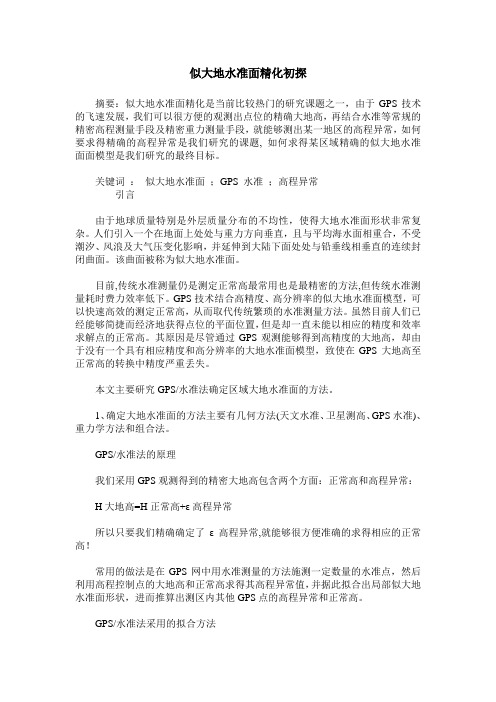
广州似大地水准面精化成果在航测数据生产中的应用(北京测绘)
广州似大地水准面精化成果在航测数据生产中的应用
杨卫军1, 林鸿1, 李长辉1, 杨光1,胡耀锋1, 罗峰1 1. 广州市城市规划勘测设计研究院
前言 ADS40 作为徕卡新的传感器,目前国内进行大规模航拍的不多。ADS40 相机携带高 精度 GPS/IMU,CORS 系统和水准面精化成果是实施 ADS40 数码行摄的前提和基础,如何 将似大地水准面精化成果应用到 ADS40 数字摄影测量的数据生产中,是其中的一个难点问 题,本文结合数据生产实践,对其进行了论述。 关键词:ADS40;坐标变换;水准面精化;数字摄影测量;数据处理
“坐标系统名称,’{ 序号椭球长半径 a 椭球知半径 b
“坐标系统名称” 0000000 “地方系统名称”△X, △Y,△Z,ωx,ωy,ωz,m} “坐标系统名称”是所要定义的坐标系名称,椭球长半径 a 与椭球短半径 b 指定义的椭 球的长、短半轴,注意要和七参数的计算相匹配。 GPS 所测的高程是沿法线方向到 WGS84 椭球面的高度,而我们测量中要求的正常高度 是沿垂线到似大地水准面的高度,这两种基准面是不一致的,它们之间的差距称为高程异常。 需要集成大地水准面精化成果对其进行高程改正。精化大地水准面对于测绘工作有重要意 义,GPS 技术结合高精度高分辨率大地水准面模型,可以取代传统的水淮测量方法测定正 高或正常高,真正实现 GPS 技术对几何和物理意义上的三维定位功能。 其关系式如下 : ζ=H-h 式中ζ为高程异常,表示似大地水准面至参考椭球面的距离。H 为大地高,h 为正常高。 以徕卡的 ADS40 数据处理软件为例,徕卡为了保证其软件开放性,可以允许用户在一 个 ASC 码文件 spheroid.tab 中添加自己的转换七参数和水准面精化成果 bin 文件。其中,bin 文件是一个开放格式的二进制文件,内有每个格网点的高程改正值。 而我们知道,七参数坐标转换是一种近似的方法,以广州为例,广州城建坐标系(东、 西)是一个平面和高程相对分离的系统,而且其主要维持的是一套平面的坐标体系,WGS-84 坐标是一套空间的坐标体系,七参数坐标转换方法并不适用。而且广州城建坐标系具备严格 的转换参数和精确的大地水准面数据,完全可以抛弃这种模式。另外,在测图完成之后,对 于本地坐标系下面的数据处理,如数据分幅等,其自动化程度不高,也是制约其生产效率的 瓶颈问题。
陆地区域_似_大地水准面精化的理论和方法

袁国辉等
陆地区域 ( 似 ) 大地水准面精化的理论和方法
25
陆地区域( 似) 大地水准面精化的理论和方法
袁国辉
*
吴云 广州 摘
要 : 首先阐述了精化 ( 似 ) 大地水准面的重要意义 , 然后系 统地介 绍了利 用现有 的重力资 料 、 高分辨 率的 DT M 以
26
城
市
勘
测
2005 年
场。其实质就是利用重力和 DT M 数据改进由重力位 模型确定的区域 ( 似) 大地水准面, 主要是改进其中短 波分量。 这一方法的应用大致有 2 种方式。 第 1 种是把 ( 似 ) 大地水准面分为 3 个部分: ( 1) 由全球定位模型计算的模型 ( 似 ) 大地水准面 高及模型重力异常; ( 2) 由局部地形影响计算的 ( 似 ) 大地水准面高和 高程异常的短波分量 ; ( 3) 由观测重力异常分别减去第一、 第二部分的重 力异常得到的观测重力异常的残差重力异常以及由此 格网数据计算的残差 ( 似 ) 大地水准面高 , 这种方式比 较适合于拥有高分辨率的地面重力数据。 第 2 种方式 是把 ( 似 ) 大地水准面 高分为 2 个部 分: ( 1) 由全球定位模型计算的模型 ( 似 ) 大地水准面 高及模型重力异常; ( 2) 地面重力异常移去第 1 部分模型值的残差重 力异常以及由此计算的残差( 似 ) 大地水准面高。经过 以往试算比较, 一般采用此种方法计算重力 ( 似 ) 大地 水准面。 重力大 地 水 准面 的 计算 采 用 经 典的 斯 托 克 斯 ( St okes) 公式和莫洛金斯基 ( Mo lodensky) 级数 ( 顾及 一次项) 。由于 F FT / F H T 应用于斯托克斯公式和莫 洛金斯基级数的技术已很成熟, 经典公式仍然是目前 国际上绝大多数国家计算重力 大地水准面的 首选公 式。重力归算采用经典的地形均衡模型( Airy - H eis kanen 系统) 。 2 2 GPS 水准( 似) 大地水准面的确定 众所周知, 任意 1 点的大地高与正常高 ( 海拔高 ) 之间的差距即为该点的高程异常。一般来说, 区域大 地水准面的精化需要建立 C 级 GPS 控制网 , 同时还应 施测 等或 等水准测量。 C 级 GPS 网点的大地高 等 测定精度一般为 2~ 5 cm ; 水准网的传递误差 ( 以
似大地水准面精化方法

似大地水准面精化方法大地水准面精化是指通过一系列测量方法和数据处理技术,对大地水准面进行精确的测量和修正,以提高其在地球表面的水平精度。
大地水准面是指在地球上表示出重力势的等势面,是地球上得以确定和准确描述水平面的参考面之一。
众所周知,地球不是一个完全规则的椭球体,而是存在着地形起伏,地壳运动、地球潮汐等因素的影响。
因此,为了能够准确地描述地球上的水平面,需要对大地水准面进行精化。
大地水准面精化一般包括以下几个步骤:基准点的选择与测量、水准线的连接与观测、数据处理与解算、精化结果的验证与分析。
首先,选择合适的基准点是大地水准面精化的基础。
基准点的选择应尽量遵循准确、稳定、可靠、参照面上分布均匀等原则。
一般选择全球一级基准点作为初始基准点,然后通过测量和观测,逐步扩展形成一个完整的基准网。
当然,在选择基准点时还需要考虑到地区特殊性,比如海陆交界处的基准点需要考虑到潮汐因素的影响。
接下来,需要连接已知的基准点,并进行水准线的观测。
通过水准仪等测量工具,沿着水准线对各个测点进行测量,获得一系列的高程数据。
这些高程数据需要考虑到大气压力、高程视线等因素的修正,以提高测量的精度。
然后,进行数据处理与解算。
在这一阶段,需要对所有的测量数据进行仔细筛选、检查和校正。
对于异常数据和误差较大的数据进行剔除,然后采用差分水准方法、高程异常平差等数学模型,对数据进行处理和解算,从而得到更加准确的大地水准面模型。
最后,需要对精化结果进行验证与分析。
通过将精化后的大地水准面与其它地理信息数据进行对比,并进行检验和分析,验证精化结果的可靠性和准确性。
如果存在明显的偏差或不符合要求,需要进行进一步的修正和改进。
总的来说,大地水准面精化是一个复杂而繁琐的工作,需要借助先进的测量工具和数学模型,同时还需要对数据进行精细的处理和解算。
只有通过科学的方法和严谨的过程,才能够实现对大地水准面的精确修正,提高其在地球表面的水平精度。
似大地水准面精化初探
似大地水准面精化初探摘要:似大地水准面精化是当前比较热门的研究课题之一,由于GPS技术的飞速发展,我们可以很方便的观测出点位的精确大地高,再结合水准等常规的精密高程测量手段及精密重力测量手段,就能够测出某一地区的高程异常,如何要求得精确的高程异常是我们研究的课题, 如何求得某区域精确的似大地水准面面模型是我们研究的最终目标。
关键词:似大地水准面;GPS 水准;高程异常引言由于地球质量特别是外层质量分布的不均性,使得大地水准面形状非常复杂。
人们引入一个在地面上处处与重力方向垂直,且与平均海水面相重合,不受潮汐、风浪及大气压变化影响,并延伸到大陆下面处处与铅垂线相垂直的连续封闭曲面。
该曲面被称为似大地水准面。
目前,传统水准测量仍是测定正常高最常用也是最精密的方法,但传统水准测量耗时费力效率低下。
GPS技术结合高精度、高分辨率的似大地水准面模型,可以快速高效的测定正常高,从而取代传统繁琐的水准测量方法。
虽然目前人们已经能够简捷而经济地获得点位的平面位置,但是却一直未能以相应的精度和效率求解点的正常高。
其原因是尽管通过GPS观测能够得到高精度的大地高,却由于没有一个具有相应精度和高分辨率的大地水准面模型,致使在GPS大地高至正常高的转换中精度严重丢失。
本文主要研究GPS/水准法确定区域大地水准面的方法。
1、确定大地水准面的方法主要有几何方法(天文水准、卫星测高、GPS水准)、重力学方法和组合法。
GPS/水准法的原理我们采用GPS观测得到的精密大地高包含两个方面:正常高和高程异常:H大地高=H正常高+ε高程异常所以只要我们精确确定了ε高程异常,就能够很方便准确的求得相应的正常高!常用的做法是在GPS网中用水准测量的方法施测一定数量的水准点,然后利用高程控制点的大地高和正常高求得其高程异常值,并据此拟合出局部似大地水准面形状,进而推算出测区内其他GPS点的高程异常和正常高。
GPS/水准法采用的拟合方法2、采用GPS/水准法在求解地面点的正常高时,常用的拟合方法如下:2.1线性拟合这种方法最为简单,对于小范围的工程测量或高程精度要求不高时是非常实用的。
似大地水准面精化

似大地水准面精化水准面精化大地高是指以参考椭球面作为高程基准面的高程系统,是地面点沿法线到参考椭球面的距离。
正高是地面点沿重力线到大地水准面的距离。
正常高是指从一地面点沿过此点的正常重力线到似大地水准面的距离。
似大地水准面精华的目的就是为了求得高程异常,以实现大地高和正常高的相互换算。
大地水准面:也称为重力等位面,它既是一个几何面,又是一个物理面,相当于地球完全静止的海水所包围的一个曲面。
物体沿该面运动时,重力不做功(如水在这个面上是不会流动的)。
大地水准面是描述地球形状的一个重要物理参考面,也是海拔高程系统的起算面。
大地水准面的确定是通过确定它与参考椭球面的间距--大地水准面差距(对于似大地水准面而言,则称为高程异常)来实现的。
似大地水准面:似大地水准面严格说不是水准面,但接近于水准面,只是用于计算的辅助面。
它与大地水准面不完全吻合,差值为正常高与正高之差。
但在海洋面上时,似大地水准面与大地水准面重合。
精确求定大地水准面差距,则是对大地水准面的精化。
精确求定高程异常,则是对似大地水准面的精化。
我国采用的是正常高系统,正常高的起算面是似大地水准面。
因此,我国主要是对似大地水准面的精化,也就是按一定的分辨率精确求定高程异常值。
精化大地水准面对于测绘工作有重要意义:首先,大地水准面或似大地水准面是获取地理空间信息的高程基准面。
其次,GPS(全球定位系统)技术结合高精度高分辨率大地水准面模型,可以取代传统的水淮测量方法测定正高或正常高,真正实现GPS技术对几何和物理意义上的三维定位功能。
再次,在现今GPS 定位时代,精化区域性大地水准面和建立新一代传统的国家或区域性高程控制网同等重要,也是一个国家或地区建立现代高程基准的主要任务,以此满足国家经济建设和测绘科学技术的发展以及相关地学研究的需要。
近年来,我国经济发达地区及中、小城市,在地形图测绘方面,对厘米级似大地水准面的需求十分迫切。
高精度的似大地水准面结合GPS定位技术所获得的三维坐标中的大地高分离求解正常高,可以改变传统高程测量作业模式,满足1:1万、1:5000甚至更大比例尺测图的迫切需要,加快数字中国、数字区域、数字城市等的建设,不但节约大量人力物力,产生巨大的经济效益,而且具有特别重要的科学意义和社会效益。
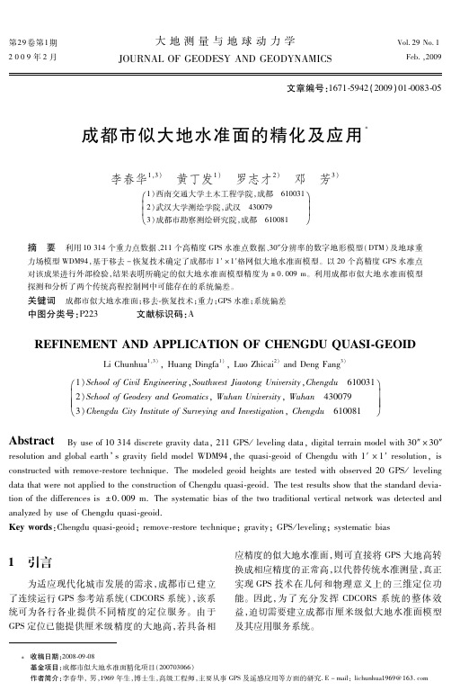
成都市似大地水准面的精化及应用
大地测量O D E S YA N DG E O D Y N A M I C S
V o l . 2 9N o . 1 F e b . , 2 0 0 9
文章编号: 1 6 7 1 5 9 4 2 ( 2 0 0 9 ) 0 1 0 0 8 3 0 5
摘 要 利用 1 03 1 4个重力点数据、 2 1 1个高精度 G P S 水准点数据、 3 0 ″ 分辨率的数字地形模型( D T M) 及地球重
力场模型 WD M 9 4 , 基于移去 - 恢复技术确定了成都市 1 ′ × 1 ′ 格网似大地水准面模型。以 2 0个高精度 G P S 水准点 0 . 0 0 9m 。利用成都市似大地水准面模型 对该成果进行外部检验, 结果表明所确定的似大地水准面模型精度为 ± 探测和分析了两个传统高程控制网中可能存在的系统偏差。
8 ] 的间接影响按下式计算 [ :
这里 G M 为地心引力常数, γ为计算点的正常重力, a 是参考椭球的长半径, 、 分别是计算点的 φ λ和 r 珔 珔 C 地心纬度、 经度和向径, n m和 S n m为完全规格化位系 珔 数, P s i n ) 是完全规格化缔合 L e g e n d r e 函数, n φ n m( m a x 为重力场模型的最大阶数( 本文取 n 3 6 0 ) 。 m a x=
6 ] 模型重力异常 [ : n m a x G Mn an 珔 g = n - 1 ) C o s m Δ ∑( λ+ G M n mc 2 ∑ ( )( m n = 2 = 0 r r 珔 珔 S i n m ) P s i n ) λ φ n ms n m(
2 似大地水准面的计算方法
目前, 局部或区域似大地水准面精化均基于移 去 恢复原理, 主要采用 F F T技术( 1 D/ 2 DF F T ) , 辅 以多项式拟合法或其他拟合方法。在实际计算中通 常采用分步计算方法, 即首先应用移去 恢复原理和 1 D F F T技术计算重力大地水准面, 然后以高精度的 G P S 水准数据作为控制, 采用多项式拟合法或其他 P S水准确 拟合方法将重力大地水准面拟合到由 G 定的几何大地水准面上, 旨在消除这两类大地水准 面之间的系统偏差, 使似大地水准面满足实际应用。 具体的计算流程可参见文献[ 1 , 2 ]。
长治市似大地水准面精化方法探讨

[ 摘
要 ] 通 过 G S技 术 快 速 、 确 获 取 地 面 点 高 程 , 代 传 统 的 低 等 级 水 准 测 量 模 式 , 大 的 改 善 传 P 精 取 极
统 的 高 费用 、 高体 力 、 消耗 的 高程 测 量 的 作 业 模 式 , 文 通 过 实 际项 目的 应 用 得 以 实现 。 高 本 [ 键 词 ] G S 高程 测量 ; 准 测 量 关 P ; 水 [ 图分 类 号 ] P 2 . 中 28 4 [ 献标识码] B 文 [ 章 编 号 ] 1 0 — 3 0 (0 2 0 —4 文 07 0021)5
C级
4 长 治 市 似 大 地 水 准 面 成 果 的 验 证 与 精 度 分 析
4 1 成 果 验 证 .
为了确 定长治 市 似 大 地 水准 面成 果 的精 度 ,
验 证该 程序 的正确 性 , 行 了两项 验证 。 进 ( ) 治市基础 测绘 GP 1长 S C级 网进 行三 维 平
点 的大地 高就 可按 一 H—H 求 得各 公 共 点 上 的 高 程异 常 , 将公 共点 的平 面 坐标 和高 程 异 常数 值 拟合 计算 , 可求 出各 点 高 程 异 常 值 , 而 确 定 即 进 区域似 大地水 准面精 化 。
区域 GP S似大 地水准 面 应保 证 由 G S间接 P 测 定 的正 常 高符 合 现行 的国家 8 5高程 基准 , 因此
21 0 2年 第 5期
・ 京测绘 ・ 北
等水 准 网 ;
GP 拟 合 平 差 三 维 成 果 的 精 度 S
3 m ; .0 c
一±
② 以建立 的 G S水 准 网作 为 局部 似 大 地水 P
似大地水准面再精化结果精度分析

似大地水准面再精化结果精度分析发布时间:2021-03-18T12:01:00.400Z 来源:《建筑实践》2020年第34期作者:陆希瑶王紫蔚[导读] 从严格意义上讲,似大地水准面并不真正属于水准面,而是一种接近水准面的封闭曲面,陆希瑶王紫蔚江苏省地质勘察技术院210049摘要:从严格意义上讲,似大地水准面并不真正属于水准面,而是一种接近水准面的封闭曲面,能够作为辅助面提高计算质量。
本文通过对似大地水准面进行分析,并结合实际对似大地水准面的精化结果精度提出个人观点,希望为关注似大地水准面精化的人群提供参考。
关键词:似大地水准面;精化;精度检测引言:似大地水准面本身并不是具备物理意义的水准面,也不是对空间各个点位唯一的高层起算面,但是在测量计算过程中,却能够发挥出非常重要的作用,有效保证计算精确度。
因此,有必要对似大地水准面再精化结果精度进行研究。
一、似大地水准面综述随着科技的持续发展,GPS连续运行参考站在各个地区得到了非常广泛的应用,此时网络实时动态差分测量模式便成为了无线通讯效果良好地区的一种重要测量方式,NRTK在实际测量过程中,据精度测试能够发现,这种测量方式的平面定位精度以及大地高定位精度能够基本满足精度要求,而利用GPS静态定位的方式其大地高精度则会进一步得到优化,然而利用GPS最终得出的结果却不是具有物理意义而正常高,而是一种几何高,只有专门利用似大地水准面模型对于进行合理转换,才能够GPS得出的大地高转变为具有足够精度的正常高。
相较于传统水准测量而言,利用似大地水准面完成GPS测量无论是测量期间的劳动强度还是测量效率都会得到大幅提高,保证测量项目的测量结果。
大地高与正高以及正常高相互之间的差别即为大地水准面差距与高程异常,想要对二者进行求解,可以以下几种方法来完成:第一,几何法。
在大地水准面精化中,几何法就是利用几何关系对测定两点大地水准面高程差做出直接测定的一种方式。
第二,天文大地测量法。
似大地水准面的精化完整版

似大地水准面的精化 HEN system office room 【HEN16H-HENS2AHENS8Q8-HENH1688】摘要随着科技的进步及城市测量基准的发展,高分辨率、高精度的城市级似大地水准面已成为现代测绘发展,尤其是信息化城市所必需的基本条件。
利用GPS定位技术以及现代地球重力场的确定理论和方法,来建立好精度、高分辨率的区域似大地水准面,具有特别重大的科学意义、社会意义和经济效益。
本文首先系统地介绍了GPS水准拟合法在确定似大地水准面中的应用,将常规的几何拟合法分为函数模型法、统计模型法、综合模型法三大类,详细介绍了他们的原理与特点,在此基础上介绍了GPS水准数据结合地球重力场模型和地形改正模型,采用移去一拟合一恢复法精化大地水准面的理论与实施步骤。
文章最后重点研究了以我国新一代似大地水准面CQG2000为平台,结合GPS水准数据精化区域似大地水准面的理论与方法。
将其作为一个平台,结合部分高精度GPS水准数据,借鉴移去恢复法原理提高区域(似)大地水准面的计算精度。
此外,本文给出了具体思想和计算步骤,并对移去恢复方法的可行性和优越性作了分析和探讨,并研究了GPS水准点个数和间距对精化结果的影响。
关键词:似大地水准面; GPS水准;移去-恢复技术; CQG2000ABSTRACTWith the progress of science and technology and the development of city measurement datum, high resolution and high precision level city like the geoid has become a modern surveying and mapping development, especially the information necessary to the city fundamental conditions. Using GPS technology and modern determination of the planet's gravitational field theory and method, to build good precision, high resolution areas like the geoid, have special major scientific significance, social significance and economic benefits.This paper first introduces GPS to determine the level of legal in like the geoid, the application of the conventional geometric intends to legal divided into function model method, statistical model method, integrated model method three categories, detailed introduces their principle and features are introduced in this paper with GPS leveling data earth gravity field model and topographic correction model, a move to a unity to refining geoid recovery act the theory and implementation procedures.Finally, in our country mainly studied a new generation like the geoid CQG2000 as the platform, combined with GPS leveling data refine the area like geoid theory and method. Will it as a platform, combined with high level of GPS data, from the recovery act to remove the principle to improve regional (like) geoid calculation accuracy. In addition, this paper gives the specific ideas and calculation steps, and to remove the feasibility and advantage of recovery method is analyzed and discussed, and the GPS leveling point number and the spacing to refine the affect the result.Keywords:Like the geoid; GPS level; Remove-recovery technology ;CQG2000目录第一章绪论引言众所周知,通过GPS测量手段可获得点的三维坐标,即点的平面位置和高程位置(即大地高)。
桂林市似大地水准面模型精化与精度评定
2018年8月第4期城市勘测Urban Geotechnical Investigation &Sur^^eyingAug.2018No.4文章编号=1672-8262(2018)04-77-04中图分类号:P223文献标识码:A 桂林市似大地水准面模型精化与精度评定方辉周淼,刘锟(桂林市测绘研究院,广西桂林541000)摘要:似大地水准面精化是建立和维持现代城市测绘基准的主要内容之一,其精度大小将直接影响城市基础设施及大型工程的建设。
因此,开展桂林市似大地水准面的精化,对桂林市的现代测绘基准的建立与维持具有重要的现实意义。
本文联合G P S观测值、精密水准资料、数字地面高程模型数据、重力场基础数据对桂林市似大地水准面进行精化,利用静态G P S水准点成果和网络R T K测量结果分别对桂林市似大地水准面精化模型进行静态和动态检验。
结果 表明:静态检验精度为±1.4cm,动态检验精度为±4.4cm,由此表明构建的桂林市似大地水准面精化模型可以满足绝大部分工程或用户对于高程精度的要求。
关键词:似大地水准面精化;高程异常;精度检验;桂林市1引言现代测绘基准的建立与维持可为城市基础设施和 大型工程的建设提供基准保障,随着现代城市建设的 发展,对测绘基准的精度要求日趋增强。
而似大地水 准面模型精化是测绘基准建立与维持的主要内容之 一。
与此同时,随着现代空间技术(如GNSS)在大地 测量中的应用,建立和维持大地测量基准的技术手段、工具及理论方法也发生了改变。
近年来,为了满足现代城市发展的要求,全国多个省及地区相继建立了各 自的似大地水准面精化模型。
如江苏省建立了省域似 大地水准面精化模型,其精度为7.8cm,分辨率为2.5^ x2.5、浙闽赣地区建立了其似大地水准面精化模型,模型内符合精度为±5.5cm,外部符合精度为±6.2cm。
此外,部分城市也构建了其似大地水准面模 型,如重庆市建立了精度为±1.6cm的似大地水准面 模型;惠州市也建立了其似大地水准面模型,模型与 C0R S相结合的实时动态应用精度可优于5cm[l〜7]。
- 1、下载文档前请自行甄别文档内容的完整性,平台不提供额外的编辑、内容补充、找答案等附加服务。
- 2、"仅部分预览"的文档,不可在线预览部分如存在完整性等问题,可反馈申请退款(可完整预览的文档不适用该条件!)。
- 3、如文档侵犯您的权益,请联系客服反馈,我们会尽快为您处理(人工客服工作时间:9:00-18:30)。
摘要随着科技的进步及城市测量基准的发展,高分辨率、高精度的城市级似大地水准面已成为现代测绘发展,尤其是信息化城市所必需的基本条件。
利用GPS定位技术以及现代地球重力场的确定理论和方法,来建立好精度、高分辨率的区域似大地水准面,具有特别重大的科学意义、社会意义和经济效益。
本文首先系统地介绍了GPS水准拟合法在确定似大地水准面中的应用,将常规的几何拟合法分为函数模型法、统计模型法、综合模型法三大类,详细介绍了他们的原理与特点,在此基础上介绍了GPS水准数据结合地球重力场模型和地形改正模型,采用移去一拟合一恢复法精化大地水准面的理论与实施步骤。
文章最后重点研究了以我国新一代似大地水准面CQG2000为平台,结合GPS水准数据精化区域似大地水准面的理论与方法。
将其作为一个平台,结合部分高精度GPS水准数据,借鉴移去恢复法原理提高区域(似)大地水准面的计算精度。
此外,本文给出了具体思想和计算步骤,并对移去恢复方法的可行性和优越性作了分析和探讨,并研究了GPS水准点个数和间距对精化结果的影响。
关键词:似大地水准面;GPS水准;移去-恢复技术;CQG2000ABSTRACTWith the progress of science and technology and the development of city measurement datum, high resolution and high precision level city like the geoid has become a modern surveying and mapping development, especially the information necessary to the city fundamental conditions. Using GPS technology and modern determination of the planet's gravitational field theory and method, to build good precision, high resolution areas like the geoid, have special major scientific significance, social significance and economic benefits.This paper first introduces GPS to determine the level of legal in like the geoid, the application of the conventional geometric intends to legal divided into function model method, statistical model method, integrated model method three categories, detailed introduces their principle and features are introduced in this paper with GPS leveling data earth gravity field model and topographic correction model, a move to a unity to refining geoid recovery act the theory and implementation procedures.Finally, in our country mainly studied a new generation like the geoid CQG2000 as the platform, combined with GPS leveling data refine the area like geoid theory and method. Will it as a platform, combined with high level of GPS data, from the recovery act to remove the principle to improve regional (like) geoid calculation accuracy. In addition, this paper gives the specific ideas and calculation steps, and to remove the feasibility and advantage of recovery method is analyzed and discussed, and the GPS leveling point number and the spacing to refine the affect the result.Keywords:Like the geoid; GPS level; Remove-recovery technology ;CQG2000目录第一章绪论 (1)1.1 引言 (1)1.1.1大地水准面似大地水准面 (1)1.1.2研究的目的及意义 (1)1.2国内外研究的现状 (3)1.2.1国外研究现状 (3)1.2.2国内的研究现状 (5)1.3本文主要研究内容 (7)第二章城市区域似大地水准面精化的误差分析 (9)2.1各种起算面及其相互关系 (9)2.1.1参考椭球面、大地高系统与大地高 (9)2.1.2 大地水准面、正高系统与正高 (10)2.1.3似大地水准面、正常高系统与正常高 (10)2.2区域似大地水准面精化的误差分析 (12)2.2.1 GPS水准精度及分辨率对高程异常的影响 .. 122.2.2重力异常精度和分辨率对高程异常的影响 .. 132.2.3 DTM精度和分辨率对似大地水准面的精度的影响 (16)2.3小结概述 (17)第三章利用GPS水准数据精化似大地水准面的方法 (19)3.1函数模型法 (19)3.1.1平面拟合法 (20)3.1.2多项式拟合法 (20)3.1.3多面函数拟合法 (21)3.1.4移动曲面法 (22)3.1.5神经网络法 (22)3.2统计模型法 (23)3.3综合模型法 (23)3.3.1最小二乘配置法 (23)3.3.2半参数模型法 (26)3.4顾及重力场模型和地形起伏的移去拟合恢复法 (26)3.4.1移去拟合恢复法的思想和计算步骤 (26)3.4.2重力场模型值的计算方法 (27)3.4.3地形改正影响的计算方法 (27)第四章以CQG2000的城市区域似大地水准面精化 (29)4.1 关于CQG2000似大地水准面 (29)4.2 以CQG2000的区域似大地水准面精化 (29)4.2.1 COG2000似大地水准面的特点和问题 (29)4.2.2 以CQG2000的区域似大地水准面精化的基本思路 (30)4.3 常用插值方法介绍 (30)4.3.1 线性插值、二次多项式插值、邻近点插值.. 304.3.2 Shepard插值原理 (31)4.4 以COG2000的移去,恢复法确定未知点高程异常 (31)4.4.1理论与实施步骤 (31)4.4.2 计算实验 (32)4.5利用GPS水准数据精化COG2000 (34)4.5.1思路和步骤 (34)4.5.2 计算试验 (35)第五章结论与展望 (38)5.1 结论 (38)5.2 展望 (40)致谢................................ 错误!未定义书签。
参考文献. (41)第一章绪论1.1 引言众所周知,通过GPS测量手段可获得点的三维坐标,即点的平面位置和高程位置(即大地高)。
我国目前采用的高程系统是正常高系统,而通常利用GPS测量所获取的大地高数据不能直接被利用而造成数据资源的浪费,如果我们能够采用物理大地测量方法精确得到同一点的大地高与正常高的差异,即大地水准面差距,GPS测得的大地高便能转换为正常高,从而使利用GPS测得的大地高这个重要数据就能够被充分利用。
大地水准面(或似大地水准面)是获取地理空间信息的高程基准面。
为此,目前包括我国在内的国际大地测量学界都在致力于研究区域性高分辨率、高精度似大地水准面或大地水准面的建立。
1.1.1大地水准面似大地水准面大地水准面由静止海水面并向大陆延伸所形成的不规则的封闭曲面。
它是重力等位面,即物体沿该面运动时,重力不做功(如水在这个面上是不会流动的)。
大地水准面是指与全球平均海平面(或静止海水面)相重合的水准面。
大地水准面是描述地球形状的一个重要物理参考面,也是海拔高程系统的起算面。
大地水准面的确定是通过确定它与参考椭球面的间距--大地水准面差距(对于似大地水准面而言,则称为高程异常)来实现的。
似大地水准面从地面点沿正常重力线量取正常高所得端点构成的封闭曲面。
似大地水准面严格说不是水准面,但接近于水准面,只是用于计算的辅助面。
它与大地水准面不完全吻合,差值为正常高与正高之差。
但在海洋面上时,似大地水准面与大地水准面重合。
1.1.2研究的目的及意义似大地水准面是获取地理空间信息的高程基准面;高精度似大地水准面是研究海洋动力环境和海洋地球物理、地球动力学等有关地球科学问题的基础;GPS技术结合高精度高分辨率大地水准面模型,可以取代传统的水准测量方法测定正高或正常高,真正实现GPS技术在几何和物理意义上的三维定位功能。
高精度、高分辨率的似大地水准而及其变化不仅为测绘学、地球物理、地球动力学、海洋学等地球科学的研究与基础工程建设应用提供基础地球空问信息,而且也是当今构建数字中同必不可少的基础信息之一。
大地水准面(或似大地水准面)是获取地理空问信息的高程基准面,似大地水准面与大地水准面在海洋上完全重合,而在大陆平原地区也几乎重合,在山区有2m~4rn的差异。
似大地水准面尽管不足大地水准面,但它可以严密的解决关于研究与地球自然地理形状有关的问题。
过去一个国家或地区的局部高程基准面通常是由该国或地区多年的验潮站资料确定的当地的平均海平面。
我国的高程基准采用的是正常高系统,而正常高系统就是以似大地水准面为基准的高程系。
建立一个高精度、三维、动态、多功能的国家空间坐标基准框架、国家高程基准框架、国家重力基准框架,以及由GPS、水准、重力等综合技术精化的高精度、高分辨率似大地水准面。
该框架工程的建成,将为基础测绘、数字中国地理空间基础框架、区域沉降监测、环境预报与防灾减灾、国防建设、海洋科学、气象预报、地学研究、交通、水利、电力等多学科研究与应用提供必要的测绘服务,具有重大的科学意义。