激光测距仪外文翻译
laser 测量原理
laser 测量原理
激光测距(laser distance measuring)是以激光器作为光源进行测距。
根据激光工作的方式,可以分为连续激光器和脉冲激光器。
激光测距的原理主要是基于光速和时间的关系,通过测量光在空气中传播的时间来计算距离。
对于脉冲激光测距,测距仪发射出的激光经被测量物体的反射后又被测距仪接收,测距仪同时记录激光往返的时间。
光速和往返时间的乘积的一半,就是测距仪和被测量物体之间的距离。
脉冲法测量距离的精度一般是在±10厘米左右,而测量盲区一般是1米左右。
此外,还有相位式激光测距,主要使用连续输出的氦氖、氩离子、氪镉等气体激光器。
相位式激光测距的原理是利用激光器的频率稳定度和传播速度,通过测量相位差来计算距离。
相位式激光测距的精度较高,可以达到毫米级别,但测量范围较小。
以上内容仅供参考,如需获取更多信息,建议查阅关于激光测距的资料或者咨询专业人士。
仪器仪表常用英语词汇

仪器仪表常用英语词汇pH计pH meterX射线衍射仪X-ray diffractometerX射线荧光光谱仪X-ray fluorescence spectrometer力测量仪表force measuring instrument孔板orifice plate文丘里管venturi tube水表water meter加速度仪accelerometer可编程序控制器programmable controller平衡机balancing machine皮托管Pitot tube皮带秤belt weigher光线示波器light beam oscillograph光学高温计optical pyrometer光学显微镜optical microscope光谱仪器optical spectrum instrument吊车秤crane weigher地中衡platform weigher字符图形显示器character and graphic display位移测量仪表displacement measuring instrument巡迴检测装置data logger波纹管bellows长度测量工具dimensional measuring instrument长度传感器linear transducer厚度计thickness gauge差热分析仪differential thermal analyzer扇形磁场质谱计sector magnetic field mass spectrometer 料斗秤hopper weigher核磁共振波谱仪nuclear magnetic resonance spectrometer 气相色谱仪gas chromatograph浮球调节阀float adjusting valve真空计vacuum gauge动圈仪表moving-coil instrument基地式调节仪表local-mounted controller密度计densitometer液位计liquid level meter组装式仪表package system减压阀pressure reducing valve测功器dynamometer紫外和可见光分光光度计ultraviolet-visible spectrometer 顺序控制器sequence controller微处理器microprocessor温度调节仪表temperature controller煤气表gas meter节流阀throttle valve电子自动平衡仪表electronic self-balance instrument电子秤electronic weigher电子微探针electron microprobe电子显微镜electron microscope弹簧管bourdon tube数字式显示仪表digital display instrument热流计heat-flow meter热量计heat flux meter热电阻resistance temperature热电偶thermocouple膜片和膜盒diaphragm and diaphragm capsule调节阀regulating valve噪声计noise meter应变仪strain measuring instrument湿度计hygrometer声级计sound lever meter黏度计viscosimeter转矩测量仪表torque measuring instrument转速测量仪表tachometer露点仪dew-point meter变送器transmitter仪器仪表常用术语性能特性performance characteristic确定仪器仪表功能和能力的有关参数及其定量的表述。
常用仪器仪表中英文对照

常用仪器仪表中英文对照光线示波器 light beam oscillograph光学高温计 optical pyrometer光学显微镜 optical microscope光谱仪器 optical spectrum instrument吊车秤 crane weigher地中衡 platform weigher字符图形显示器 character and graphic display位移测量仪表 displacement measuring instrument巡检测装置 data logger波纹管 bellowsX射线衍射仪 X-ray diffractometerX射线荧光光谱仪 X-ray fluorescence spectrometer力测量仪表 force measuring instrument孔板 orifice plate文丘里管 venturi tube水表 water meter加速度仪 accelerometer可编程序控制器 programmable controller平衡机 balancing machine皮托管 Pitot tube皮带秤 belt weigher长度测量工具 dimensional measuring instrument长度传感器 linear transducer厚度计 thickness gauge差热分析仪 differential thermal analyzer扇形磁场质谱计 sector magnetic field mass spectrometer 料斗秤 hopper weigher核磁共振波谱仪 nuclear magnetic resonance spectrometer 气相色谱仪 gas chromatograph浮球调节阀 float adjusting valve真空计 vacuum gauge动圈仪表 moving-coil instrument基地式调节仪表 local-mounted controller密度计 densitometer液位计 liquid level meter组装式仪表 package system热流计 heat-flow meter热量计 heat flux meter热电阻 resistance temperature热电偶 thermocouple膜片和膜盒 diaphragm and diaphragm capsule调节阀 regulating valve噪声计 noise meter应变仪 strain measuring instrument湿度计 hygrometer声级计 sound lever meter黏度计 viscosimeter转矩测量仪表 torque measuring instrument转速测量仪表 tachometer露点仪 dew-point meter变送器 transmitter减压阀 pressure reducing valve测功器 dynamometer紫外和可见光分光光度计 ultraviolet-visible spectrometer 顺序控制器 sequence controller微处理器 microprocessor温度调节仪表 temperature controller煤气表 gas meter节流阀 throttle valve电子自动平衡仪表 electronic self-balance instrument电子秤 electronic weigher电子微探针 electron microprobe电子显微镜 electron microscope弹簧管 bourdon tube数字式显示仪表 digital display instrument光线示波器 light beam oscillograph光学高温计 optical pyrometer光学显微镜 optical microscope光谱仪器 optical spectrum instrument吊车秤 crane weigher地中衡 platform weigher字符图形显示器 character and graphic display位移测量仪表 displacement measuring instrument巡检测装置 data logger波纹管 bellowsX射线衍射仪 X-ray diffractometerX射线荧光光谱仪 X-ray fluorescence spectrometer 力测量仪表 force measuring instrument孔板 orifice plate文丘里管 venturi tube水表 water meter加速度仪 accelerometer可编程序控制器 programmable controller平衡机 balancing machine皮托管 Pitot tube皮带秤 belt weigher长度测量工具 dimensional measuring instrument长度传感器 linear transducer厚度计 thickness gauge差热分析仪 differential thermal analyzer扇形磁场质谱计 sector magnetic field mass spectrometer 料斗秤 hopper weigher核磁共振波谱仪 nuclear magnetic resonance spectrometer 气相色谱仪 gas chromatograph浮球调节阀 float adjusting valve真空计 vacuum gauge动圈仪表 moving-coil instrument基地式调节仪表 local-mounted controller密度计 densitometer液位计 liquid level meter组装式仪表 package system热流计 heat-flow meter热量计 heat flux meter热电阻 resistance temperature热电偶 thermocouple膜片和膜盒 diaphragm and diaphragm capsule调节阀 regulating valve噪声计 noise meter应变仪 strain measuring instrument湿度计 hygrometer声级计 sound lever meter黏度计 viscosimeter转矩测量仪表 torque measuring instrument转速测量仪表 tachometer露点仪 dew-point meter变送器 transmitter减压阀 pressure reducing valve测功器 dynamometer紫外和可见光分光光度计 ultraviolet-visible spectrometer 顺序控制器 sequence controller微处理器 microprocessor温度调节仪表 temperature controller煤气表 gas meter节流阀 throttle valve电子自动平衡仪表 electronic self-balance instrument电子秤 electronic weigher电子微探针 electron microprobe电子显微镜 electron microscope弹簧管 bourdon tube数字式显示仪表 digital display instrument。
仪器中英文对照
仪器中文名称仪器英文名称英文缩写坐标机 Coordinate Measuring Machine CMM光学测量机械 Optical Measuring Machine OMM投影仪Profile projector高度规 H eight gauge HG圆柱塞规Plug gauge PG工具显微镜toolmakers Microscope放大镜Magnifying glass扫描仪Light Spot Scanner色差机Color-difference meters光泽机gloss meter平台(大理石平台) Surface plates精密比重计proportion meter扭力校正仪torque meter多功能长度校正器multi—functional length calibrator雷射测高仪Laser altimeter instrument硬度测试笔pencil a durometer熔融指数测试仪melt flow indexers温湿度记录仪Hybrid recorder(multipoint type recorder)安培小时Ampere hour电热恒温水槽Electric thermostat sink导电度仪Electrolytic conductance meter拉力压力万能试验机Universal tension and compression testing machine二次元影像测量仪Projectors手提式盐度计Salinity of hand-held深度规D epth gages厚度规thickness meters量表Scale玻璃光学尺Glass optical device标准光泽板Standard shiny plateZ轴设定器Z—axis set meter3D测定器3D—Determination meters平台。
Platform铅笔硬度计Pencil hardness testers百格刀Hundred grid knifeRCA试验机RCA testing machineR角规R meters直角尺Rectangular device照度计luminance meter电子称Electronics Weighing酸度计Acidity meter推拉力计push and pull meter环境实验设备温度,湿度Equipment of the environmental testing for temperature and humidity 高斯机Gauss meter微量欧姆计Micro-ohms of Meters网络分析仪Network Analyzer激光尘埃粒子计数器laser Airbome Particle counter炉温追踪记录器Datapaq easy track冲击试验机Measuring Instrument for Shock摆锤式冲击试验机Pendulum Impact Testing Machine拉伸试验机Tensile testing machine标准光源箱Standard light box阶梯规ladder Machine多功能转速测试仪Speed—tester盐水喷雾试验机Salt water spray test machine橡胶硬度机The hardness of rubber弹簧耐久试验机 Spring durability testing machine电镀层膜厚测定仪Coating thickness Measurer手机翻盖寿命试验机Clamshell phones life testing machine塞尺(厚薄规)Feeler gauge烤箱oven红外线测温仪Infrared thermometer摩擦试验机Friction Testing Machine测力计Dynamometers电阻测试仪Resistance meter风速仪Anemometer数显千分尺Digital MicrometerpH计 pH Meters水质分析仪 Water Test Kits电子显微镜 Electro Microscopy光学显微镜 Optical Microscopy金相显微镜 Metallurgical Microscopy粘度计Viscometer金属/材料元素分析仪 Metal/material elemental analysisX射线荧光光谱仪 X—Ray Fluorescence Spectrometer XRF 电子水平仪Electronic level meter螺纹千分尺Screw thread micrometer百分表Bore gauge游标卡尺V ernier caliper带表卡尺Dial caliper电子数显卡尺Calliper with electronic digital display深度标游卡尺Depth Vernier caliper电子数显深度卡尺Depth caliper with electronic digital display 带表高度卡尺Dial height Calliper高度游标卡尺Height Vernier Caliper电子数显高度卡尺Height caliper with electronic digital display 万用表V olometer数字温度计Digital thermometer温湿度计Humidity Sensor热电偶测温仪T hermocouple涂层测厚仪Coating thickness Measurer水平尺Level Ruler块规Gauge block环规Ring gauge螺纹规Thread gauge半径规Radius gauge表面粗糙测量仪surface roughness tester硬度测量仪Hardness tester秒表stopwatch立体显微镜stereomicroscope万能角度尺universal bevel protractors一般术语:1。
图雅得Trueyard激光测距仪
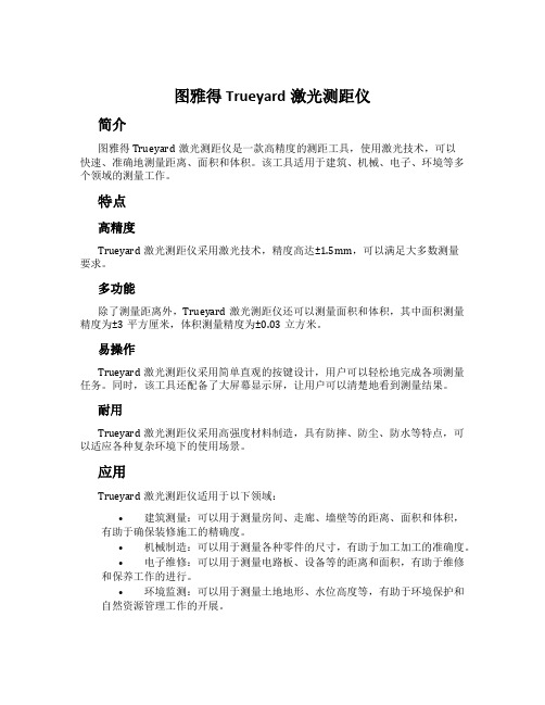
图雅得Trueyard激光测距仪简介图雅得Trueyard激光测距仪是一款高精度的测距工具,使用激光技术,可以快速、准确地测量距离、面积和体积。
该工具适用于建筑、机械、电子、环境等多个领域的测量工作。
特点高精度Trueyard激光测距仪采用激光技术,精度高达±1.5mm,可以满足大多数测量要求。
多功能除了测量距离外,Trueyard激光测距仪还可以测量面积和体积,其中面积测量精度为±3平方厘米,体积测量精度为±0.03立方米。
易操作Trueyard激光测距仪采用简单直观的按键设计,用户可以轻松地完成各项测量任务。
同时,该工具还配备了大屏幕显示屏,让用户可以清楚地看到测量结果。
耐用Trueyard激光测距仪采用高强度材料制造,具有防摔、防尘、防水等特点,可以适应各种复杂环境下的使用场景。
应用Trueyard激光测距仪适用于以下领域:•建筑测量:可以用于测量房间、走廊、墙壁等的距离、面积和体积,有助于确保装修施工的精确度。
•机械制造:可以用于测量各种零件的尺寸,有助于加工加工的准确度。
•电子维修:可以用于测量电路板、设备等的距离和面积,有助于维修和保养工作的进行。
•环境监测:可以用于测量土地地形、水位高度等,有助于环境保护和自然资源管理工作的开展。
使用注意事项•Trueyard激光测距仪需要在平坦、更少杂物的表面使用,以确保测量的准确性。
•使用时需要避免直接对着强光源测量,以免干扰数据的准确性。
•Trueyard激光测距仪需要及时清洁镜头,以确保测量精度。
•在使用前请先阅读说明书并按照要求进行使用。
总结图雅得Trueyard激光测距仪是一款高精度、多功能、易操作、耐用的测距工具,适用于建筑、机械、电子、环境等多个领域的测量工作。
在使用时需要注意一些问题,以确保测量的准确性和工具的寿命。
测绘类词汇中英文对照

测绘类词汇中英文对照阿贝比长原理Abbe comparator principle阿达马变换Hadamard transformation安平精度setting accuracy岸台,*固定台base station暗礁reef靶道工程测量target road engineering survey半导体激光器semiconductor laser半日潮港semidiurnal tidal harbor半色调halftone饱和度saturation北极星任意时角法method by hour angle of Polaris贝塞尔大地主题解算公式Bessel formula for solution of geodetic problem 贝塞尔椭球Bessel ellipsoid贝叶斯分类Bayesian classification被动式遥感passive remote sensing本初子午线prime meridian比较地图学comparative cartography比较地图学comparative cartography比例尺scale比例量表ratio scaling比例误差proportional error比值变换ratio transformation比值增强ratio enhancement闭合差closing error闭合差closure闭合差closing error闭合差closure闭合导线closed traverse闭合导线closed traverse闭合水准路线closed leveling line闭合水准路线closed leveling line边长中误差mean square error of side length边交会法linear intersection边角测量triangulateration边角交会法linear-angular intersection边角网triangulateration network边缘检测edge detection边缘增强edge enhancement编绘compilation编绘compilation编绘原图compiled original编绘原图compiled original变比例投影varioscale projection变换光束测图affine plotting变线仪variomat变形观测控制网control network for deformation observation 变形观测控制网control network for deformation observation 变形椭圆indicatrix ellipse标称精度nominal accuracy标称精度nominal accuracy标尺rod标尺staff标高差改正correction for skew normals标高差改正correction for skew normals标界测量survey for marking of boundary标志灯,*回光灯signal lamp标准差standard deviation标准配置点Gruber point标准纬线standard parallel冰后回弹post glacial rebound波茨坦重力系统Potsdam gravimetric system波带板zone plate波浪补偿compensation of undulation波浪补偿compensation of undulation波浪补偿heave compensation波浪补偿器,*涌浪滤波器heave compensator波罗-科普原理Porro-Koppe principle波谱测定仪spectrometer波谱集群spectrum cluster波谱特征空间spectrum feature space波谱特征曲线spectrum character curve波谱响应曲线spectrum response curve波束角beam angle波束角wave beam angle泊位Berth补偿器compensator补偿器compensator补偿器补偿误差compensating error of compensator补偿器补偿误差compensating error of compensator布格改正Bouguer correction布格异常Bouguer anomaly布隆斯公式Bruns formula布耶哈马问题Bjerhammar problem采剥工程断面图striping and mining engineering profile采剥工程综合平面图synthetic plan of striping and mining 采场测量stope survey采掘工程平面图mining engineering plan采区测量survey in mining panel采区联系测量connection survey in mining panel采区联系测量connection survey in mining panel采样sampling采样间隔sampling interval彩色编码color coding彩色编码color coding彩色变换color transformation彩色变换color transformation彩色复制color reproduction彩色复制color reproduction彩色感光器材color sensitive material彩色感光器材color sensitive material彩色红外片,*假彩色片false color film彩色红外片,*假彩色片color infrared film彩色红外片,*假彩色片color infrared film彩色片color film彩色片color film彩色摄影color photography彩色摄影color photography彩色校样color proof彩色校样color proof彩色样图color manuscript彩色样图color manuscript彩色增强color enhancement彩色增强color enhancement彩色坐标系color coordinate system彩色坐标系color coordinate system参考数据reference data参考椭球reference ellipsoid参考效应reference effect参数平差,*间接平差parameter adjustment侧方交会side intersection侧扫声呐side scan sonar侧视雷达side-locking radar测标[measuring] mark测杆measuring bar测高仪Altimeter测绘标准standards of surveying and mapping测绘联合会International Union of Surveying and Mapping 测绘学geomatics测绘学SM测绘学surveying and mapping测绘仪器instrument of surveying and mapping测角中误差mean square error of angle observation测距定位系统,*圆-圆定位系统range positioning system 测距雷达range-only radar测距盲区range hole测距仪rangefinder测量标志survey mark测量船survey vessel测量规范specifications of surveys测量控制网surveying control network测量平差adjustment of observation测量平差survey adjustment测量学surveying测流current surveying测流current surveying测深改正correction of depth测深改正correction of depth测深杆sounding pole测深精度total accuracy of sounding测深仪读数精度reading accuracy of sounder测深仪发射参数,*测深仪零线transmiting line of sounder 测深仪回波信号echo signal of sounder测深仪记录纸recording paper of sounder测速标marks for measuring velocity测图卫星mapping satellite测微密度计microdensitometer测微目镜micrometer eyepiece测微器micrometer测线survey line测站station测站归心station centring层间改正plate correction觇牌target长度标准检定场standard field of length厂址测量surveying for site selection超导重力仪superconductor gravimeter超焦点距离hyperfocal distance超近摄影测量macrophotogrammetry潮汐表tidal tables潮汐波tidal wave潮汐调和常数tidal harmonic constants潮汐调和分析tidal harmonic analysis潮汐非调和常数tidal nonharmonic constants潮汐非调和分析tidal nonharmonic analysis潮汐摄动tidal perturbation潮汐因子tidal factor潮汐预报tidal prediction潮信表tidal information panel沉船wreck沉降观测settlement observation成像光谱仪imaging spectrometer成像雷达imaging radar城市测量urban survey城市地形测量urban topographic survey城市地形图topographic map of urban area城市基础地理信息系统UGIS城市基础地理信息系统urban geographical information system 城市控制测量urban control survey城市制图urban mapping乘常数multiplication constant尺度参数scale parameter抽象符号abstract symbol触觉地图tactual map船台,*移动台mobile station垂核面vertical epipolar plane垂核线vertical epipolar line垂球plumb bob垂线偏差改正correction for deflection of the vertical垂线偏差改正correction for deflection of the vertical垂直角vertical angle垂直折光误差vertical refraction error垂直折光系数vertical refraction coefficient垂准仪,*铅垂仪plumb aligner纯重力异常pure gravity anomaly磁变年差annual change of magnetic variation磁测深magnetic sounding磁测深线magnetic sounder磁方位角magnetic azimuth磁力扫海测量magnetic sweeping磁力异常区magnetic anomaly area磁偏角magnetic variation磁倾角magnetic dip磁像限角magnetic bearing磁子午线magnetic meridian粗差gross error粗差检测gross error detection粗码C/A Code粗码Coare/Acquision Code粗码C/A Code粗码Coare/Acquision Code打样Proofing大比例尺测图large scale topographical mapping大潮升spring rise大地测量边值问题geodetic boundary value problem大地测量参考系geodetic reference system大地测量数据库geodetic database大地测量学geodesy大地测量仪器geodetic instrument大地方位角geodetic azimuth大地高ellipsoidal height大地高geodetic height大地基准geodetic datum大地经度geodetic longitude大地水准面geoid大地水准面高geoidal height大地水准面高geoidal undulation大地天顶延迟atmosphere zenith delay大地天文学geodetic astronomy大地网geodetic network大地纬度geodetic latitude大地线geodesic大地原点geodetic origin大地主题反解inverse solution of geodetic problem大地坐标geodetic coordinate大地坐标系geodetic coordinate system大陆架地形测量continental shelf topographic survey大陆架地形测量continental shelf topographic survey大气传输特性characteristics of atmospheric transmission 大气传输特性characteristics of atmospheric transmission 大气窗atmospheric window大气改正,*气象改正atmospheric correction大气透过率atmospheric transmissivity大气噪声atmospheric noise大气阻力摄动atmospheric drag perturbation大像幅摄影机large format camera大像幅摄影机LFC大洋地势图GEBCO大洋地势图general bathymetric chart of the oceans大圆航线图great circle sailing chart带谐系数coefficient of zonal harmonics带谐系数coefficient of zonal harmonics带状平面图zone plan单差相位观测single difference phase observation单点定位point positioning单片坐标量测仪monocomparator单位权unit weight单位权方差,*方差因子variance of unit weight弹道摄影测量ballistic photogrammetry弹道摄影机ballistic camera当地平均海面local mean sea level挡差改正correction of scale difference挡差改正correction of scale difference导标leading beacon导弹定向测量missile orientation survey导弹试验场工程测量engineering survey of missile test site 导航台定位测量navigation station location survey导航台定位测量navigation station location survey导航图navigation chart导航图navigation chart导航线,*叠标线leading line导入高程测量induction height survey导线边traverse leg导线测量traverse survey导线点traverse point导线横向误差lateral error of traverse导线角度闭合差angle closing error of traverse导线结点junction point of traverses导线曲折系数meandering coefficient of traverse导线全长闭合差total length closing error of traverse导线网traverse network导线相对闭合差relative length closing error of traverse导线折角traverse angle导线纵向误差longitudinal error of traverse岛屿测量island survey岛屿联测island-mainland connection survey岛屿图island chart倒锤[线]观测,倒锤法inverse plummet observation灯[光性]质characteristic of light灯[光性]质characteristic of light灯标light beacon灯船light ship灯船light vessel灯浮标light buoy灯高height of light灯光节奏flashing rhythm of light灯光射程light range灯光遮蔽Eclipse灯光周期light period灯色light color灯塔light house等比线isometric parallel等高距contour interval等高距contour interval等高棱镜contour prism等高棱镜contour prism等高线Contour等高线Contour等高仪astrolabe等积投影equivalent projection等级结构hierarchical organization等角定位格网equiangular positioning grid等角条件,*正形投影conformal projection等角条件,*正形投影conformal projection等精度[曲线]图equiaccuracy chart等距量表interval scaling等距投影equidistant projection等距圆弧格网equilong circle arc grid等量纬度isometric latitude等偏摄影parallel-averted photography等倾摄影equally tilted photography等权代替法method of equalweight substitution 等值灰度尺equal value gray scale等值区域图,*分区量值地图choroplethic map 等值区域图,*分区量值地图choroplethic map 等值线地图isoline map等值线法isoline method低潮线low water line底板测点floor station底点纬度latitude of pedal底色去除under color removal底色增益under color addition底质bottom characteristics底质quality of the bottom底质采样bottom characteristics sampling底质调查bottom characteristics exploration底质分布图bottom sediment chart地产界测量property boundary survey地磁经纬仪magnetism theodolite地磁仪magnetometer地底点ground nadir point地固坐标系body-fixed coordinate system地固坐标系earth-fixed coordinate system地基系统ground-based system地极坐标系coordinate system of the pole地极坐标系coordinate system of the pole地籍cadastre地籍cadastre地籍簿land register地籍册cadastral lists地籍册cadastral lists地籍测量cadastral survey地籍测量cadastral survey地籍调查cadastral inventory地籍调查cadastral inventory地籍更新renewal of the cadastre地籍管理cadastral survey manual地籍管理cadastral survey manual地籍图cadastral map地籍图cadastral map地籍修测cadastral revision地籍修测cadastral revision地籍制图cadastral mapping地籍制图cadastral mapping地界测量land boundary survey地壳均衡isostasy地壳均衡改正isostatic correction地壳形变观测crust deformation measurement地壳形变观测crust deformation measurement地块测量parcel survey地类界图land boundary map地理格网geographic grid地理视距geographical viewing distance地理信息传输geographic information communication 地理信息系统geographic information system地理信息系统GIS地理坐标geographic graticule地理坐标参考系geographical reference system地貌图geomorphological map地貌形态示量图morphometric map地面接收站ground receiving station地面立体测图仪terrestrial stereoplotter地面摄谱仪terrestrial spectrograph地面摄影测量terrestrial photogrammetry地面摄影机terrestrial camera地面实况ground truth地面照度illuminance of ground地名geographical name地名place name地名标准化place-name standardization地名录gazetteer地名数据库place-name database地名索引geographical name index地名通名geographical general name地名学toponomastics地名学toponymy地名转写geographical name transcription地名转写geographical name transliteration地平线摄影机horizon camera地平线像片horizon photograph地倾斜观测ground tilt measurement地球定向参数earth orientation parameter地球定向参数EOP地球同步卫星geo-synchronous satellite地球椭球earth ellipsoid地球位,*大地位geopotential地球位数geopotential number地球位系数potential coefficient of the earth地球形状earth shape地球形状Figure of the earth地球仪globe地球引力摄动terrestrial gravitational perturbation地球重力场模型earth gravity model地球资源卫星earth resources technology satellite地球资源卫星ERTS地球自转参数earth rotation parameter地球自转参数ERP地球自转角速度rotational angular velocity of the earth 地势图hypsometric map地图map地图编绘map compilation地图编辑map editing地图编辑大纲map editorial policy地图表示法cartographic presentation地图表示法cartographic presentation地图传输cartographic communication地图传输cartographic communication地图叠置分析map overlay analysis地图分类cartographic classification地图分类cartographic classification地图分析cartographic analysis地图分析cartographic analysis地图符号库map symbols bank地图符号学cartographic semiology地图符号学cartographic semiology地图负载量map load地图复杂性map complexity地图复制map reproduction地图感受map perception地图更新map revision地图集信息系统Atlas information system地图利用map use地图量算法cartometry地图量算法cartometry地图模型,*制图模型cartographic model地图模型,*制图模型cartographic model地图内容结构cartographic organization地图内容结构cartographic organization地图判读map interpretation地图评价cartographic evaluation地图评价cartographic evaluation地图潜信息cartographic potential information 地图潜信息cartographic potential information 地图清晰性map clarity地图色标color chart地图色标color chart地图色标map color standard地图色谱map color atlas地图设计map design地图数据结构map data structure地图数据库cartographic database地图数据库cartographic database地图数字化map digitizing地图投影map projection地图显示map display地图信息cartographic information地图信息cartographic information地图信息系统cartographic information system 地图信息系统CIS地图信息系统cartographic information system 地图信息系统CIS地图选取cartographic selection地图选取cartographic selection地图学cartography地图学cartography地图研究法cartographic methodology地图研究法cartographic methodology地图易读性map legibility地图印刷map printing地图语法cartographic syntactics地图语法cartographic syntactics地图语言cartographic language地图语言cartographic language地图语义cartographic semantics地图语义cartographic semantics地图语用cartographic pragmatics地图语用cartographic pragmatics地图阅读map reading地图整饰map decoration地图制图map making地图制图软件cartographic software地图制图软件cartographic software地图注记map lettering地下管线测量underground pipeline survey地下铁道测量subway survey地下铁道测量underground railway survey地下油库测量underground oil depot survey地心经度geocentric longitude地心纬度geocentric latitude地心引力常数geocentric gravitational constant 地心坐标系geocentric coordinate system地形测量topographic survey地形底图base map of topography地形改正topographic correction地形数据库topographic database地形图topographic map地形图更新revision of topographic map地形图图式topographic map symbols地震台精密测量precise survey at seismic station 地质测量geological survey地质点测量geological point survey地质略图geological scheme地质剖面测量geological profile survey地质剖面图geological section map典型图形平差adjustment of typical figures点方式point mode点位中误差mean square error of a point点下对中centering under point点下对中centering under point点状符号point symbol电磁波测距electromagnetic distance measurement电磁波测距仪electromagnetic distance measuring instrument电磁传播[时延]改正correction for radio wave propagation of time signal 电磁传播[时延]改正correction for radio wave propagation of time signal 电荷耦合器件CCD电荷耦合器件charge-coupled device电荷耦合器件CCD电荷耦合器件charge-coupled device电离层折射改正ionospheric refraction correction电子测距仪EDM电子测距仪electronic distance measuring instrument电子出版系统electronic publishing system电子地图集electronic atlas电子分色机color scanner电子分色机color scanner电子海图electronic map电子海图数据库ECDB电子海图数据库electronic chart database电子海图显示和信息系统ECDIS电子海图显示和信息系统electronic chart display and information system 电子经纬仪electronic theodolite电子平板仪electronic plane-table电子求积仪electronic planimeter电子水准仪electronic level电子速测仪,*全站仪electronic tachometer电子显微摄影测量nanophotogrammetry电子显微摄影测量nanophotogrammetry电子相关electronic correlation电子印像机electronic printer调绘Annotation调焦误差error of focusing调频频率modulation frequency调制传递函数modulation transfer function调制传递函数MTF调制器modulator叠栅条纹图,*莫尔条纹图moirétopography顶板测点roof station定深扫海sweeping at definite depth定位标记positioning mark定位点间距positioning interval定位检索,*开窗检索retrieval by windows定位统计图表法positioning diagram method定线测量Alignment survey定向连接点connection point定向连接点connection point for orientation定向连接点connection point定向连接点connection point for orientation定性检索retrieval by header定影Fixing动感autokinetic effect动画引导animated steering动画制图animated mapping动态定位kinematic positioning独立交会高程点elevation point by independent intersection独立模型法空中三角测量independent model aerial triangulation 独立坐标系independent coordinate system度盘circle度盘circle断面仪Profiler对景图front view对流层折射改正tropospheric refraction correction对数尺logarithmic scale对中杆centering rod对中杆centering rod多倍仪multiplex多边形地图polygonal map多边形结构polygon structure多边形平差法Adjustment by method of polygon多波束测探multibeam echosounding多波束测探系统multibeam sounding system多层结构multi layer organization多级纠正multistage rectification多焦点投影polyfocal projection多路径效应multipath effect多媒体地图multimedia map多年平均海面multi-year mean sea level多谱段扫描仪MSS多谱段扫描仪multispectral scanner多谱段摄影multispectral photography多谱段摄影机multispectral camera多谱段遥感multispectral remote sensing多时相分析multi-temporal analysis多时相遥感multi-temporal remote sensing多星等高法equal-altitude method of multi-star多用途地籍multi-purpose cadastre多余观测redundant observation多圆锥投影polyconic projection厄特沃什效应Eötvös effect二值图像binary image发光二极管LED发光二极管light-emitting diode法方程normal equation法方程normal equation法截面normal section法截面normal section法伊改正Faye correction反差Contrast反差Contrast反差系数contrast coefficient反差系数contrast coefficient反差增强contrast enhancement反差增强contrast enhancement反立体效应pseudostereoscopy反射波谱reflectance spectrum反束光导管摄影机return beam vidicon camera反像mirror reverse反像wrong-reading反转片reversal film范围法area method方差-协方差传播律variance-covariance propagation law 方差-协方差矩阵variance-covariance matrix方里网kilometer grid方位角中误差mean square error of azimuth方位圈compass rose方位圈compass rose方位投影azimuthal projection方向观测法method by series方向观测法method of direction observation防波堤Breakwater防波堤mole房地产地籍real estates cadastre仿射纠正affine rectification放样测量setting-out survey非地形摄影测量nontopographic photogrammetry非地形摄影测量nontopographic photogrammetry非监督分类unsupervised classification非量测摄影机non-metric camera非量测摄影机non-metric camera菲列罗公式Ferrero's formula分版原图Flaps分瓣投影interrupted projection分层layer分层设色表graduation of tints分层设色法hypsometric layer分潮Constituent分潮Constituent分潮迟角epoch of partial tide分潮振幅amplitude of partial tide分带纠正zonal rectification分带子午线zone dividing meridian分类器classifier分类器classifier分区统计图表法cartodiagram method分区统计图表法chorisogram method分区统计图表法cartodiagram method分区统计图表法chorisogram method分区统计图表法,*等值区域法cartogram method分区统计图表法,*等值区域法cartogram method分区统计图法,*等值区域法choroplethic method分区统计图法,*等值区域法choroplethic method分色,*分色参考图color separation分色,*分色参考图color separation分析地图analytical map风讯信号杆wind signal pole浮标Buoy浮雕影像地图picto-line map浮子验潮仪float gauge符号化symbolization辐射三角测量radial triangulation辐射线格网radial positioning grid辐射校正radiometric correction辐射遥感器radiation sensor负荷潮load tide负片negative负片negative附参数条件平差condition adjustment with parameters附参数条件平差condition adjustment with parameters附合导线connecting traverse附合导线connecting traverse附合水准路线annexed leveling line附加位additional potential附条件参数平差,*附条件间接平差parameter adjustment with conditions 复测法repetition method复垦测量reclaimation survey复照仪reproduction camera副台slave station概率判决函数Probability decision function概然误差probable error干出礁covers and uncovers rock干出礁covers and uncovers rock干涉雷达INSAR干涉雷达interometry SAR感光sensitization感光材料sensitive material感光测定sensitometry感光度sensitivity感光特性曲线characteristic curve of photographic transmission 感光特性曲线characteristic curve of photographic transmission 感受效果perceptual effect港界harbor boundary港口port港口工程测量harbor engineering survey港湾测量harbor survey港湾锚地图集harbor/anchorage atlas港湾图harbor chart高差仪statoscope高程height高程导线height traverse高程点elevation point高程基准height datum高程控制测量vertical control survey高程控制点vertical control point高程控制网vertical control network高程系统height system高程异常height anomaly高程中误差mean square error of height高度角altitude angle高度角elevation angle高密度数字磁带HDDT高密度数字磁带high density digital tape高斯-克吕格投影Gauss-Krüger projection高斯平面子午线收敛角Gauss grid convergence高斯平面坐标系Gauss plane coordinate system高斯投影方向改正arc-to-chord correction in Gauss projection 高斯中纬度公式Gauss midlatitude formula格网单元cell格网单元cell跟踪数字化tracing digitizing工厂现状图测量survey of present state at industrial site 工程测量engineering survey工程测量学engineering surveying工程经纬仪engineer's theodolite工程控制网engineering control network工程摄影测量engineering photogrammetry工程水准仪engineer's level工业测量系统industrial measuring system工业摄影测量industrial photogrammetry公路工程测量road engineering survey功率谱power spectrum共面方程coplanarity equation共面方程coplanarity equation共线方程collinearity equation共线方程collinearity equation构像方程imaging equation古地图ancient map骨架航线,*构架航线,测控条control strip骨架航线,*构架航线,测控条control strip固定平极fixed mean pole固定误差fixed error固定相移fixed phase drift固体潮[solid] Earth tide固体激光器solid-state laser管道测量pipe survey管道综合图synthesis chart of pipelines贯通测量holing through survey贯通测量breakthrough survey惯性测量系统inertial surveying system惯性测量系统ISS惯性坐标系inertial coordinate system惯用点conventional name惯用点conventional name灌区平面布置图irrigation layout plan光电测距导线EDM traverse光电测距仪electro-optical distance measuring instrument 光电等高仪photoelectric astrolabe光电遥感器photoelectric sensor光电中星仪photoelectric transit instrument光碟,*光盘CD光碟,*光盘compact disc光碟,*光盘CD光碟,*光盘compact disc光谱感光度,*光谱灵敏度spectral sensitivity光圈,*有效孔径Aperture光圈号数f-number光圈号数stop-number光束法空中三角测量bundle aerial triangulation光栅grating广播星历broadcast ephemeris归化纬度reduced latitude归心改正correction for centering归心改正correction for centering归心元素elements of centring龟纹moire规划地图planning map规矩线register mark国际测绘联合会IUSM国际测量师联合会Fédération Internationale des Géométres国际测量师联合会FIG国际大地测量协会IAG国际大地测量协会International Association of Geodesy国际大地测量与地球物理联合会International Union of Geodesy and Geophysics 国际大地测量与地球物理联合会IUGG国际地球参考架international terrestrial reference frame国际地球参考架ITRF国际地球自转服务局IERS国际地球自转服务局International Earth Rotation Service国际海道测量组织IHO国际海道测量组织International Hydrography Organization国际海图international chart国际航天测量与地球学学院ITC国际矿山测量学会International Society of Mine Surveying国际摄影测量与遥感学会International Society for Photogrammetry and Remote S国际摄影测量与遥感学会ISPRS国际天球参考架ICRF国际天球参考架international celestial reference frame国际协议原点CIO国际协议原点Conventional International Origin国际协议原点CIO国际协议原点Conventional International Origin国际原子时IA T国际原子时international atomic time国际制图协会ICA国际制图协会International Cartographic Association国家地图集national atlas国家地图集national atlas国家基础地理信息系统national fundamental geographic information system 国家基础地理信息系统national fundamental geographic information system 海[洋]图集marine atlas海岸coast海岸coast海岸地形测量coast topographic survey海岸地形测量coast topographic survey海岸图coast chart海岸图coast chart海岸线coast line海岸线coast line海岸性质nature of the coast海岸性质nature of the coast海拔height above sea level海道测量,*水道测量hydrographic survey海道测量学,*水道测量学hydrography海底成像系统seafloor imaging system海底地貌submarine geomorphology海底地貌图submarine geomorphologic chart海底地势图submarine situation chart海底地形测量bathymetric surveying海底地形图bathymetric chart海底地质构造图submarine structural chart海底电缆submarine cable海底管道submarine pipeline海底控制网submarine control network海底倾斜改正seafloor slope correction海底声标acoustic beacon on bottom海底施工测量submarine construction survey海底隧道测量submarine tunnel survey海福德椭球Hayford ellipsoid海军导航卫星系统Navy Navigation Satellite System海军导航卫星系统NNSS海军导航卫星系统Navy Navigation Satellite System海军导航卫星系统NNSS海军勤务测量naval service survey海军勤务测量naval service survey海控点hydrographic control point海流计current meter海流计current meter海面地形sea surface topography海区界线sea area bounding line海区资料调查sea area information investigation海区总图general chart of the sea海图Chart海图Chart海图比例尺Chart scale海图比例尺Chart scale海图编号Chart numbering海图编号Chart numbering海图编制Chart compilation海图编制Chart compilation海图标题Chart title海图标题Chart title海图大改正Chart large correction海图大改正Chart large correction海图分幅Chart subdivision海图分幅Chart subdivision海图改正Chart correction海图改正Chart correction海图投影Chart projection海图投影Chart projection海图图廓Chart boarder海图图廓Chart boarder海图图式symbols and abbreviations on chart 海图小改正Chart small correction海图小改正Chart small correction海图制图charting海图制图charting海图注记lettering of chart海洋测绘marine charting海洋测绘数据库marine charting database海洋测量marine survey海洋测量定位marine survey positioning海洋磁力测量marine magnetic survey海洋磁力图marine magnetic chart海洋磁力异常marine magnetic anomaly海洋大地测量marine geodetic survey海洋大地测量学marine geodesy海洋工程测量marine engineering survey海洋划界测量marine demarcation survey海洋环境图marine environmental chart海洋气象图marine meteorological chart海洋生物图marine biological chart海洋水文图marine hydrological chart海洋水准测量marine leveling海洋卫星Seasat海洋质子采样器marine bottom proton sampler 海洋质子磁力仪marine proton magnetometer海洋重力测量marine gravimetry海洋重力仪marine gravimeter海洋重力异常marine gravity anomaly海洋重力异常图Chart of marine gravity anomaly 海洋重力异常图Chart of marine gravity anomaly 海洋专题测量marine thematic survey海洋资源图marine resource chart航标表list of lights航带法空中三角测量strip aerial triangulation航道channel航道channel航道fairway航道图navigation channel chart航道图navigation channel chart航高flight height航高flying height航海天文历nautical almanac航海天文历nautical almanac航海通告NM航海通告notice to mariners航海通告NM航海通告notice to mariners航海图nautical chart航海图nautical chart航迹track航空摄谱仪aerial spectrograph航空摄影aerial photography航空摄影测量aerial photogrammetry航空摄影测量aerophotogrammetry航空摄影机aerial camera航空图aeronautical chart航空遥感aerial remote sensing航空重力测量airborne gravity measurement航路指南sailing directions航路指南SD航摄计划flight plan of aerial photography航摄领航navigation of aerial photography航摄领航navigation of aerial photography航摄漏洞aerial photographic gap航摄软片aerial film航摄像片,航空像片aerial photograph航摄质量quality of aerophotography航速speed航天飞机space shuttle航天摄影space photography航天摄影测量,*太空摄影测量space photogrammetry航天遥感space remote sensing航向course航向course航向倾角longitudinal tilt航向倾角pitch航向重叠end overlap航向重叠fore-and-aft overlap航向重叠forward overlap航向重叠longitudinal overlap航行通告notice to navigator航行通告notice to navigator航行图sailing chart航行障碍物navigation obstruction航行障碍物navigation obstruction合成地图synthetic map合成孔径雷达SAR合成孔径雷达synthetic aperture radar合点控制vanishing point control河道整治测量river improvement survey河外致密射电源,*类星体extragalactic compact radio source 核点epipole核面epipolar plane核线epipolar line核线epipolar ray核线相关epipolar correlation盒式分类法box classification method黑白片black-and-white film黑白摄影black-and-white photography恒时钟sidereal clock恒星摄影机stellar camera恒星时sidereal time恒星中天测时法method of time determination by star transit 横断面测量cross-section survey横断面测量cross-section survey横断面图cross-section profile横断面图cross-section profile横轴投影transverse projection红外测距仪infrared EDM instrument红外辐射计infrared radiometer红外片infrared film。
仪器仪表常用英语词汇
仪器仪表常用英语词汇pH 计 pH meterX 射线衍射仪 X-ray diffractometerX 射线荧光光谱仪X-ray fluorescence spectrometer力测量仪表force measuring instrument孔板 orifice plate文丘里管venturi tube水表 water meter加速度仪accelerometer可编程序控制器programmable controller平衡机balancing machine皮托管Pitot tube皮带秤belt weigher光线示波器light beam oscillograph光学高温计optical pyrometer光学显微镜optical microscope光谱仪器optical spectrum instrument吊车秤crane weigher地中衡platform weigher字符图形显示器character and graphic display位移测量仪表displacement measuring instrument巡迴检测装置data logger波纹管bellows长度测量工具dimensional measuring instrument长度传感器linear transducer厚度计thickness gauge差热分析仪differential thermal analyzer扇形磁场质谱计sector magnetic field mass spectrometer 料斗秤hopper weigher核磁共振波谱仪 nuclear magnetic resonancespectrometer 气相色谱仪 gas chromatograph 浮球调节阀 float adjusting valve真空计vacuum gauge动圈仪表moving-coil instrument基地式调节仪表local-mounted controller密度计densitometer液位计liquid level meter组装式仪表package system减压阀pressure reducing valve测功器dynamometer紫外和可见光分光光度计ultraviolet-visible spectrometer 顺序控制器sequence controller微处理器microprocessor温度调节仪表temperature controller煤气表gas meter节流阀throttle valve电子自动平衡仪表electronic self-balance instrument电子秤electronic weigher电子微探针electron microprobe电子显微镜electron microscope弹簧管bourdon tube数字式显示仪表digital display instrument热流计heat-flow meter热量计heat flux meter热电阻resistance temperature热电偶thermocouple膜片和膜盒diaphragm and diaphragm capsule调节阀regulating valve噪声计noise meter应变仪strain measuring instrument湿度计hygrometer声级计sound lever meter黏度计viscosimeter转矩测量仪表torque measuring instrument转速测量仪表tachometer露点仪dew-point meter变送器transmitter仪器仪表常用术语性能特性performance characteristic确定仪器仪表功能和能力的有关参数及其定量的表述。
激光测距仪LASER的由来和演变(浅显易懂版)

激光测距仪LASER的由来和演变(浅显易懂版)。
激光测距仪的英文名称是Laser rangefinder,Laser取自英文Light Amplification by Stimulated Emission of Radiation的各单词的头一个字缩写词,意思是受激辐射的光放大。
英译为“镭射”也是激光最初的中文名。
激光从出现到转为实用用了几十年,发展到现在无处不在又是几十年,激光及应用实际上是根据社会需求进步而得以发展。
从社会角度看,激光的产生改变了人类的生活,使之更加方便快键。
随着科学技术的发展,激光技术将会更加提高和应用在我们生活中。
激光测距是激光最早的应用之一。
这是由于激光具有方向性强、亮度高、单色性好等许多优点。
世界上第一台激光器,是由美国休斯飞机公司的科学家梅曼于1960年,首先研制成功的。
美国军方很快就在此基础上开展了对军用激光装置的研究。
1961年,第一台军用激光测距仪通过了美国军方论证试验,对此后激光测距仪很快就进入了实用联合体。
激光测距仪是利用激光进行测距的一种仪器。
它的作用原理很简单:通过测定激光开始发射到激光从目标反射回来的时间来测定距离。
1965年前苏联利用激光测地球和月球之间距离(380′103km)误差只有250m。
1969年美国人登月后置反射镜于月面,也用激光测量地月之距,误差只有15cm。
目前激光在测距方面的产品主要有两种,手持激光测距仪和望远镜式激光测距仪,手持激光测距仪精度高,测量距离短适合短程高精度测量。
望远镜激光测距仪适合远程测量,精度低一些。
手持激光测距仪第一品牌是德国徕卡,望远镜测距仪的品牌比较多,针对应用领域不同可选品牌有美国图柏斯、美国镭创、美国onick和应用于军工领域的加拿大纽康。
手持测距仪领域欧洲领先,军工测距仪方面美国领先。
在功能上激光测距仪主要分为以下三类:(1)一维激光测距仪用于距离测量、定位;激光测距仪(2)二维激光测距仪(Scanning Laser Range finder)用于轮廓测量,定位、区域监控等领域;(3)三维激光测距仪(3D Laser Range finder)用于三维轮廓测量,三维空间定位等领域。
- 1、下载文档前请自行甄别文档内容的完整性,平台不提供额外的编辑、内容补充、找答案等附加服务。
- 2、"仅部分预览"的文档,不可在线预览部分如存在完整性等问题,可反馈申请退款(可完整预览的文档不适用该条件!)。
- 3、如文档侵犯您的权益,请联系客服反馈,我们会尽快为您处理(人工客服工作时间:9:00-18:30)。
Laser rangefinderA long range laser rangefinder is capable of measuring distance up to 20 km; mounted on a tripod with an angular mount. The resulting system also provides azimuth and elevation measurements.A laser rangefinder is a device which uses a laser beam to determine the distance to an object. The most common form of laser rangefinder operates on the time of flight principle by sending a laser pulse in a narrow beam towards the object and measuring the time taken by the pulse to be reflected off the target and returned to the sender. Due to the high speed of light, this technique is not appropriate for high precision sub-millimeter measurements, where triangulation and other techniques are often used.PulseThe pulse may be coded to reduce the chance that the rangefinder can be jammed. It is possible to use Doppler effect techniques to judge whether the object is moving towards or away from the rangefinder, and if so how fast.PrecisionThe precision of the instrument is determined by the rise or fall time of the laser pulse and the speed of the receiver. One that uses very sharp laser pulses and has a very fast detector can range an object to within a few millimeters.RangeDespite the beam being narrow, it will eventually spread over long distances due to the divergence of the laser beam, as well as due to scintillation and beam wander effects, caused by the presence of air bubbles in the air acting as lenses ranging in size from microscopic to roughly half the height of the laser beam's path above the earth. These atmospheric distortions coupled with the divergence of the laser itself and with transverse winds that serve to push the atmospheric heat bubbles laterally may combine to make it difficult to get an accurate reading of the distance of an object, say, beneath some trees or behind bushes, or even over long distances of more than 1 km in open and unobscured desert terrain.Some of the laser light might reflect off leaves or branches which are closer thanthe object, giving an early return and a reading which is too low. Alternatively, over distances longer than 1200 ft (365 m), the target, if in proximity to the earth, may simply vanish into a mirage, caused by temperature gradients in the air in proximity to the heated surface bending the laser light. All these effects have to be taken into account.CalculationThe distance between point A and B is given byD=ct/2where c is the speed of light in the atmosphere and t is the amount of time for the round-trip between A and B.where is the delay which made by the light traveling and is the angular frequency of optical modulation.Then substitute the values in the equation D=ct/2,D=1/2 ct=1/2 c·φ/ω=c/(4πf) (Nπ+Δφ)=c/4f (N+ΔN)=U(N+)in this equation, U stands for the unit length.Δφ stands for the delay part which does not fulfill π.ΔN stands the decimal value.DiscriminationSome instruments are able to determine multiple returns, as above. These instruments use waveform-resolving detectors, which means they detect the amount of light returned over a certain time, usually very short. The waveform from a laser pulse that hits a tree and then the ground would have two peaks. The first peak would be the distance to the tree, and the second would be the distance to the ground.Using wavefront sensing, it is possible to determine both the closest and the farthest object at a given point. This makes it possible for aircraft-mounted instruments to see "through" dense canopies[clarification needed Please explain how lasers see through canopies]and other semi-reflective surface such as the ocean, leading to many applications for airborne instruments such as:1. Creating "bare earth" topographic maps - removing all trees2. Creating vegetation thickness maps3. Bathymetry(measuring topography under the ocean)4. Forest firehazardTechnologiesTime of flight - this measures the time taken for a light pulse to travel to the target and back. With the speed of light known, and an accurate measurement of the time taken, the distance can be calculated. Many pulses are fired sequentially and the average response is most commonly used. This technique requires very accurate sub-nanosecond timing circuitry.Multiple frequency phase-shift- this measures the phase shift of multiple frequencies on reflection then solves some simultaneous equations to give a final measure.Interferometry - the most accurate and most useful technique for measuring changes in distance rather than absolute distances.ApplicationsMilitaryAn American soldier with a GVS-5 laser rangefinder.A Dutch ISAF sniper team displaying their Accuracy International AWSM .338 Lapua Magnum rifle and Leica/Vectronix VECTOR IV laser rangefinder binoculars. Rangefinders provide an exact distance to targets located beyond the distance of point-blank shooting to snipers and artillery. They can also be used for military reconciliation and engineering.Handheld military rangefinders operate at ranges of 2 km up to 25 km and are combined with binoculars or monoculars. When the rangefinder is equipped with a digital magnetic compass (DMC) and inclinometer it is capable of providing magnetic azimuth, inclination, and height (length) of targets. Some rangefinders can also measure a target's speed in relation to the observer. Some rangefinders have cable or wireless interfaces to enable them to transfer their measurement(s) data to other equipment like fire control computers. Some models also offer the possibility to use add-on night vision modules. Most handheld rangefinders use standard or rechargeable batteries.The more powerful models of rangefinders measure distance up to 25 km and arenormally installed either on a tripod or directly on a vehicle or gun platform. In the latter case the rangefinder module is integrated with on-board thermal, night vision and daytime observation equipment. The most advanced military rangefinders can be integrated with computers.To make laser rangefinders and laser-guided weapons less useful against military targets, various military arms may have developed laser-absorbing paint for their vehicles. Regardless, some objects don't reflect laser light very well and using a laser rangefinder on them is difficult.3-D ModellingThis LIDAR scanner may be used to scan buildings, rock formations, etc., to produce a 3D model. The LIDAR can aim its laser beam in a wide range: its head rotates horizontally, a mirror flips vertically. The laser beam is used to measure the distance to the first object on its path.Laser rangefinders are used extensively in 3-D object recognition, 3-D object modelling, and a wide variety of computer vision-related fields. This technology constitutes the heart of the so-called time-of-flight3D scanners. In contrast to the military instruments described above, laser rangefinders offer high-precision scanning abilities, with either single-face or 360-degree scanning modes.A number of algorithms have been developed to merge the range data retrieved from multiple angles of a single object to produce complete 3-D models with as little error as possible. One of the advantages that laser rangefinders offer over other methods of computer vision is that the computer does not need to correlate features from two images to determine depth information as in stereoscopic methods.Laser rangefinders used in computer vision applications often have depth resolutions of tenths of millimeters or less. This can be achieved by using triangulation or refraction measurement techniques as opposed to the time of flight techniques used in LIDAR.ForestryLaser rangefinder TruPulse used for forest inventories (in combination with Field-Map technology)Special laser rangefinders are used in forestry. These devices have anti-leaf filtersand work with reflectors. Laser beam reflects only from this reflector and so exact distance measurement is guaranteed. Laser rangefinders with anti-leaf filter are used for example for forest inventories.SportsLaser rangefinders may be effectively used in various sports that require precision distance measurement, such as golf, hunting, and archery. Some of the more popular manufacturers are: Opti-logic Corporation, Bushnell, LaserTechnology, Trimble, Leica, Newcon Optik, Nikon, and Swarovski Optik.Industry production processesAn important application is the use of laser Range finder technology during the automation of stock management systems and production processes in steel industry.SafetyLaser rangefinders for consumers are laser class 1 devices and therefore are considered eyesafe. Some laser rangefinders for military use exceed the laser class 1 energy levels.HistoryDevelopment of the methods used in modern printed circuit boards started early in the 20th century. In 1903, a German inventor, Albert Hanson, described flat foil conductors laminated to an insulating board, in multiple layers. Thomas Edison experimented with chemical methods of plating conductors onto linen paper in 1904. Arthur Berry in 1913 patented a print-and-etch method in Britain, and in the United States Max Schoop obtained a patent[1] to flame-spray metal onto a board through a patterned mask. Charles Durcase in 1927 patented a method of electroplating circuit patterns.The Austrian Jewish engineer Paul Eisler invented the printed circuit while working in England around 1936 as part of a radio set. Around 1943 the USA began to use the technology on a large scale to make proximity fuses for use in World War II . After the war, in 1948, the USA released the invention for commercial use. Printed circuits did not become commonplace in consumer electronics until the mid-1950s, after the Auto-Sembly process was developed by the United States Army.Before printed circuits (and for a while after their invention), point-to-point construction was used. For prototypes, or small production runs, wire wrap or turret board can be more efficient. Predating the printed circuit invention, and similar in spirit, was John Sargrove's 1936–1947 Electronic Circuit Making Equipment (ECME) which sprayed metal onto a Bakelite plastic board. The ECME could produce 3 radios per minute.During World War II, the development of the anti-aircraft proximity fuse required an electronic circuit that could withstand being fired from a gun, and could be produced in quantity. The Centralab Division of Globe Union submitted a proposal which met the requirements: a ceramic plate would be screenprinted with metallic paint for conductors and carbon material for resistors, with ceramic disc capacitors and subminiature vacuum tubes soldered in place.Originally, every electronic component had wire leads, and the PCB had holes drilled for each wire of each component. The components' leads were then passed through the holes and soldered to the PCB trace. This method of assembly is called through-hole construction. In 1949, Moe Abramson and Stanislaus F. Danko of the United States Army Signal Corps developed the Auto-Sembly process in which component leads were inserted into a copper foil interconnection pattern and dip soldered. The patent they obtained in 1956 was assigned to the U.S. Army. [4] With the development of board lamination and etching techniques, this concept evolved into the standard printed circuit board fabrication process in use today. Soldering could be done automatically by passing the board over a ripple, or wave, of molten solder in a wave-soldering machine. However, the wires and holes are wasteful since drilling holes is expensive and the protruding wires are merely cut off.In recent years, the use of surface mount parts has gained popularity as the demand for smaller electronics packaging and greater functionality has grown.激光测距仪激光测距仪是一种设备,它采用了激光束来确定对象的距离。