雅思小作文范文-地图
雅思地图题范文
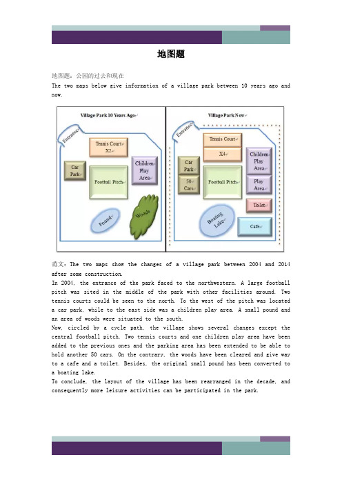
地图题地图题:公园的过去和现在The two maps below give information of a village park between 10 years ago andnow.范文:The two maps show the changes of a village park between 2004 and 2014 after some construction.In 2004, the entrance of the park faced to the northwestern. A large football pitch was sited in the middle of the park with other facilities around. Two tennis courts could be seen to the north. To the west of the pitch was located a car park, while to the east side was a children play area. A small pound and an area of woods were situated to the south.Now, circled by a cycle path, the village shows several changes except the central football pitch. Two tennis courts and one children play area have been added to the previous ones and the parking area has been extended to be able to hold another 50 cars. On the contrary, the woods have been cleared and give way to a cafe and a toilet. Besides, the original small pound has been converted to a boating lake.To conclude, the layout of the village has been rearranged in the decade, and consequently more leisure activities can be participated in the park.he i rb ei n ga re go od fo rs o 地图题:城市布局变迁The two maps show the changes of a city from 1960 to now.范文:The two maps show the development of a city from 1960 to the present.In 1960, the city was mainly based on the harbour and freight ships were moored in the northeast dock. To the east of the harbour was a business area, which was connected with the harbor and a stadium on the southern side of the river by trams. Moreover, two residential blocks were constructed at both the northern and southern ends of the city.Several major changes to the city have been observed since then. In 2014, the residential area in the north has given way to an extended business area of the one in the east. The previous dock has been occupied by some newly built restaurants and bars. The original intersecting tram frame has been simplified to a single line. Some sports facilities have been constructed between the southern residential area and the stadium, which is now also linked with the old business area by a footbridge over the river.To summarise, the landscape of the city has been rearranged, with more business replacing industry around the bay.d fo r地图题:学院布局变化The map below gives information about a college at present and its future view in 2015 after reconstruction.范文:The two figures demonstrate the estimated changes of a college between 2014 and 2015.At present, a garden lies in the northern part of the college and five car parks are located in the west. Both of them are linked to the school building by a footpath, while its entrance is in front of the garden. Inside thebuilding, a lunch area and two classrooms lie in the western side, while one more classroom, a reception and a library are in the eastern part. For the southern edge, there is a toilet in the middle, and a bus stop on the southwestern corner, accessed by a road.In 2015, several changes are expected to be witnessed. The garden and the footpath will be removed, since the teaching building will be extended. A new shop will be established in the building’s northwestern corner, and thelibrary will be moved to the southwestern end. Between them, there will be the original lunch area and one classroom, while other four classrooms will be seen in the opposite side. The entrance will be rebuilt in the middle southern edge,e an dAl t h i ng si nt he i rb ei n ga re go od adjacent to the bus stop, and the corridor behind it will be replaced by a reception.To summarize, more rooms and car parks will be constructed in the college during the period.地图题:消防设备布置The diagram shows the fire plan for the second floor of a student dorm building in a university. Summarise the information by selecting and reporting the main features and make comparison where relevant.范文:The map illustrates the escape routes in case of fire on the second floor of a university dormitory. There are one lift, two stairways and seven bedrooms on this rectangle shape floor, all with access to the corridor in the center. Once the building is on fire, the stairs on the south-west corner is convenient for the students living in the west part of the floor, specifically, Bedroom 1, 2 and 3 to escape through the corridor because Bedroom 1 and 2 are located in the northwest corner and Bedroom 3 is right opposite the stairway. When they rush out of the building, they can meet the others at the Meeting Point 1 outside the stairway.Another stairway which is sited at the north side of floor, with the lift at the west and Bedroom 7 the east, offers another escaping way in case of fire. Bedroom 4, and 6 are on the south side of the corridor but face to this stairway, and Bedroom 5 is at the east side of the floor, next to Bedroom 6,s o therefore it is also easy for the dwellers in these three rooms to rush out. Once they get out of the building, they would meet at the Meeting Point 2 near the stair room.When you are old and grey and full of sleep,And nodding by the fire, take down this book,And slowly read, and dream of the soft look Your eyes had once, and of their shadows deep;How many loved your moments of glad grace,And loved your beauty with love false or true,But one man loved the pilgrim soul in you,And loved the sorrows of your changing face;And bending down beside the glowing bars,Murmur, a little sadly, how love fledAnd paced upon the mountains overhead And hid his face amid a crowd of stars.The furthest distance in the worldIs not between life and deathBut when I stand in front of you Yet you don't know thatI love you.The furthest distance in the worldIs not when I stand in front of youYet you can't see my loveBut when undoubtedly knowing the love from both Yet cannot be together.The furthest distance in the worldIs not being apart while being in loveBut when I plainly cannot resist the yearningYet pretending you have never been in my heart. The furthest distance in the worldIs not struggling against the tidesBut using one's indifferent heartTo dig an uncrossable riverFor the one who loves you.。
雅思小作文医院地图高分范文

雅思小作文医院地图高分范文医院地图口语化描述。
一走进医院,大厅里亮堂堂的,特别宽敞。
正中间有个服务台,有啥不懂的,找那儿就对了,他们会告诉你咋走。
四周都是候诊区,椅子坐着特舒服,还有电视看,等看病的时候也不无聊。
往西边儿走,就是住院部了。
楼挺高的,每层都有牌子告诉你
这是哪一层。
病房有单人间、双人间,还有多人间的,看你想住哪种。
病房里啥都有,环境也干净,住着挺舒服的。
医院东边儿是门诊部,啥科室都有,内科、外科、儿科……你
想要的都有。
诊室里设备都是新的,医生护士也都特专业,看病放心。
北边儿是药房和实验室。
药房里药特全,药师们都很负责,会
告诉你咋吃药。
实验室里设备也高级,检测结果特准,医生看病就
靠它了。
南边儿是紧急通道和停车场。
紧急通道宽宽的,有啥紧急情况,
病人能很快被送去治疗。
停车场车位也多,开车来的话停车也方便。
这医院设计得真人性化!。
雅思小作文地图题范文
现在停车场改成了一个剧院。
The car park has been removed and replaced by a theatre.城镇A的家庭数量从1937年到2020年将翻一番。
The number of homes in Town A is likely to double(is likely to= is predicted to /is estimated to/is projected to/is expected to )又可为:It is likely that the number of homes in Town A will double.(it is likely that = it is predicted/estimated/projected/ expected that…..)细节变化地图每个细节变化都要提到,不要忽视一个细节语态雅思小作文地图题写作用被动语态,因为叙述的是一个事实,被动语态表达的更加的清晰,准确。
如: 2000年在城镇A 新建了一个医院:A new hospital was established in Town A in 2000.2014年开始,流程图与地图题的频率已经于其他图表题的频率不相上下,甚至有超过他们的趋势,2014年截止9月20日地图题已经考了4次,流程图也是4次。
你还在备考时忽略这两种图吗?地图题句式总结:1. A lies/is situated in/is located in/on/to the east of B.A 位于B的东面2.A covers an area of about….square meters/ hectares.A的面积大概有。
平方米/公顷A covers a small area in 1980.在1980年 A的面积很小。
3.A, which used to be located in…., is replaced by….原本位于。
作文范文之雅思小作文地图题怎么写
雅思小作文地图题怎么写【篇一:雅思小作文地图题讲解】一个地图题的开头:the map about the development of the village sufficiently illustrates the way of progress of this area. in this map, we can find four main sectors and two main roads intersected withone railway and one motor way. it seems the overall development of this village has strong connection with the construction of roads.雅思小作文地图题词汇part 1:表时间流程图和地图题中都可能涉及时间表达。
流程题中,使用较多的是过程时长的表述,而地图题的时间使用则体现为地理变迁的时间变化。
一般在方位选址图题中较少出现。
确切的时间指引,既增加文章的自然和连贯度,也能体现行文的精确性。
常见表示时间的词:in few hours几小时during the period of … 在…期间after 10 days 10天后from…to 从…到…between …and 在…之间over the…year period在一个…年期间5 years before 5年前over the subsequent …years近连续几年例句:the process lasts for up to 7 days and the products are finally distributed to customers.a decade earlier几十年前 from that moment on从那时起 after a while一会 since自从 since then自从 finally最后part 2:表空间空间表达地图题出现概率较高,但流程图也偶尔出现。
8.21雅思地图小作文7分范文日本美国办公室对比

8.21雅思地图小作文7分范文:日本美国办公室对比地图题The graph below shows a typical American and a Japanese office.Summarise the information by selecting and reporting the mainfeatures and make comparisons where relevant.» You should write at least 150 words.2021年雅思写作预测大题库限时免费领取,想要领取的同学可以戳:2021年雅思写作预测大题库领取!你将遇到的99%的考题都收录在内!(含300篇高分范文)情报圈的第10篇小作文范文解析1题目大意图片展示了日本和美国的办公室,描述各自的主要特征ing进行对比。
2思路解析这道题是一道地图,但比较少见,地图类一般考的多的都是城镇变迁这个类别,而这次则是给出了静态图,介绍了美和日本办公室的相关格局,因此很多同学会一下子不知道该怎么写。
具体写作上,时态上可以用一般现在时,文章结构上采用一个图形写一段。
可以先看个日本办公室,总体是按照部门从上到下来落座;而美的办公室更多按照功能来划分,从左到右来落座,分成功能房,员工区,管理区。
此外,要注意的是,小作文不建议学生过多的添加主观评论,比如日本人是一个压迫式的格局,美国是一个平等的格局等等。
这些都是没有必要的,措辞一定要客观,看到什么写什么即可。
3高分范文示例开始段 - 改写题目:The two diagrams illustrate the structure in a typical Japanese office compared wit h that in an American office.主体段-1:日本办公室的描述A careful analysis of the first diagram makes it clear that seats are generally arranged based on one’s title. Specifically, it is the general manager who holds the central as well as top position in the office. As to other employees, they are divided, horizontally, into different groups. Within each section, the white-collar workers are seated on either side of the table, with their section manager sitting in the front.主体段-2:美国办公室的描述及对比不同Different from what is organized in Japanese offices, the American tend to utilize the space by function. The office is separated, from left to right, into three parts. On the left side, there are four rooms for copying, storage as well as conference. Adjacent to these four rooms are a number of independent studios for employees who are seated in the middle of the office. On the right side are several rooms for section managers and the general manager. Most notably, the seat for the general manager is located in the lowest right corner, contrary to the top middle position for the manager in Japan.结尾段In summary, clear from these two pictures is the specific organization of a typical Japanese office versus that of an American. It is noticeable that the Japanese tend to arrange the space according to one’s position while the American prefer a function-based office。
雅思写作小作文范文 雅思写作地图题map 地区变化.doc
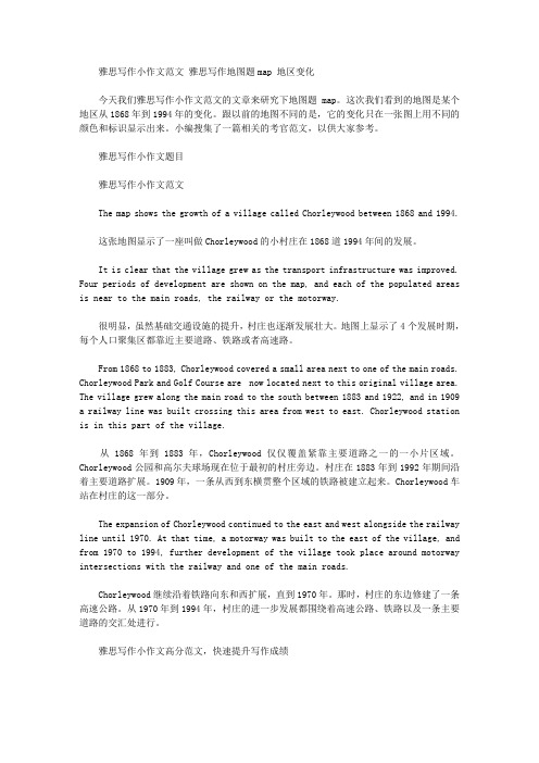
雅思写作小作文范文雅思写作地图题map 地区变化今天我们雅思写作小作文范文的文章来研究下地图题map。
这次我们看到的地图是某个地区从1868年到1994年的变化。
跟以前的地图不同的是,它的变化只在一张图上用不同的颜色和标识显示出来。
小编搜集了一篇相关的考官范文,以供大家参考。
雅思写作小作文题目雅思写作小作文范文The map shows the growth of a village called Chorleywood between 1868 and 1994.这张地图显示了一座叫做Chorleywood的小村庄在1868道1994年间的发展。
It is clear that the village grew as the transport infrastructure was improved. Four periods of development are shown on the map, and each of the populated areas is near to the main roads, the railway or the motorway.很明显,虽然基础交通设施的提升,村庄也逐渐发展壮大。
地图上显示了4个发展时期,每个人口聚集区都靠近主要道路、铁路或者高速路。
From 1868 to 1883, Chorleywood covered a small area next to one of the main roads. Chorleywood Park and Golf Course are now located next to this original village area. The village grew along the main road to the south between 1883 and 1922, and in 1909 a railway line was built crossing this area from west to east. Chorleywood station is in this part of the village.从1868年到1883年,Chorleywood仅仅覆盖紧靠主要道路之一的一小片区域。
雅思小作文-地图流程图
Chronologically, during the first 15 years from 1868 to 1883, Chorleywood was merely a very small village with one main road to its west. From 1883 to 1922, we see that the village expanded to south, almost tripled the original scale.
先描述S1地理位置,再写其空间优势
01
02
In contrast, the suggested location, S2, is right in the town centre, which would be good for local residents. Theoretically, the store could be accessed by road or rail from the surrounding towns, including Bransdon, but as the central area is a no-traffic zone, cars would be unable to park and access would be difficult.
雅思小作文地图题之地理变迁题高分范文
雅思小作文地图题之地理变迁题高分范文雅思小作文地图题主要包括选址类与地理变迁类两大类型,今天小编就给大家介绍下雅思小作文地图题之地理变迁题高分范文。
雅思地理变迁题范文篇1题目:剑桥雅思官方指南中T est 7 Task 1的作文,原题目是The map below shows the village of Stokeford in 1930 and in 2010.从题目可知,该题为地图题,主要有两张地图组成,属于地理变迁类。
题目描述的是Stokeford村庄在1930年和2010年的发展变化。
地理变迁题的写作,考生要根据时间以及空间顺序来写,小作文的写作还要格外注意时态与语态。
从图中得知,没有变化的是横跨河流的桥梁以及邮局的位置,而有所变化的是商店,农场没有了;新增几条支路以及很多住宅;花园被改建成了养老院;学校的规模也扩大了。
因此,从变化中,我们在写主体段的时候可以分别描述这个村庄在1930年和2010年的发展变化较好写一些。
下面,我们来具体看看每个段落的详细内容以及进行分析。
第一段描写的是第一张地图的内容:先整体描述在1930年,River Stoke贯穿了Stokeford村庄的东北角到西南角,地图上显示有一座桥,连接河流两岸地区。
In 1930, the River Stoke crossed through the Stokeford from northeast corner to southwest corner and a bridge in the top was over this river for providing the path for the road in this map.第二段主要描述的是第二幅图的内容,即70年后该村庄的发展变化。
最后,小编将范文分享给大家,考生们可以参照学习学习。
In 1930, the River Stoke crossed through the Stokeford from northeast corner to southwest corner and a bridge in the top was over this river for providing the path for the road in this map. It is obvious that there is nothing in the west side of the river.Moving to the eastside of the river stoke, the primary school was right in the center of the maps well as next to the farmland. To the south side of the primary school was the gardens with a large house. Besides, along the road from north to south, several buildings, shops, post office and farmland were located in the west side of it.After 70 years, as can be seen from the map of 2010, there was no change happened in the west side of the river and about the post office, but all of the farmlands and shops had been demolished. Moreover, the primary school had been expanded with two buildings and to the south of which, the original gardens had been reduced and developed as the retirement home.Lastly, several branches of the road had been constructed with plenty of houses, which had been established along branches.雅思地理变迁题范文篇2The two maps below show an island before and after the construction of some tourist facilities.Summarise the information by selecting and reporting the main features, and make comparisons where relevant.Write at least 150 Words.参考范文The two maps demonstrate the changes made to an island after it was turned into a tourist resort.The holiday resort which occupied about three quarter of the island consists of a reception building, a restaurant, and numerous chalets; all located within a walking distance. In addition, the reception area is also connected directly to a newly built pier which made it more accessible by visitors. For the convenience of the guests, a vehicle track that connects the pier,the reception and the restaurant was also constructed.To further promote the island as a holiday attraction, various spots of the island have been upgraded for recreational activities. For example, swimming is now available at the beach near the west end of the island and sailing can be done near the pier of the resort.Overall, the transformation of the island into a vacation spot has brought much improvements to the island without any deforestation. As a matter of fact, there are now more trees in the island than before.雅思地理变迁题范文篇3话题:The map shows the village of Chorleywood showing development between 1868 and 1994范文The map shows the growth of a village called Chorleywood between 1868 and 1994.It is clear that the village grew as the transport infrastructure was improved. Four periods of development are shown on the map, and each of the populated areas is near to the main roads, the railway or the motorway.From 1868 to 1883, Chorleywood covered a small area next to one of the main roads. Chorleywood Park and Golf Course is now located next to this original village area. The village grew along the main road to the south between 1883 and 1922, and in 1909 a railway line was built crossing this area from west to east. Chorleywood station is in this part of the village.The expansion of Chorleywood continued to the east and west alongside the railway line until 1970. At that time, a motorway was built to the east of the village, and from 1970 to 1994, further development of the village took place aroundmotorway intersections with the railway and one of the main roads.雅思地理变迁题范文篇4The map below shows the development of a seaside village between 1995 and present.Write a short report for a university lecturer describing the information shown below.Write at least 150 words.参考范文:The two maps show the layout of the same seaside village in 1995 and at present.Overall, it is evident that the infrastructure for housing and recreation has increased at the expense of agricultural land and commercial fishing.The most notable changes are the disappearance of the fishing port and adjacent fish market, as well as the creation of a golf course and tennis courts in the north-east, where farmland and a forest park were still found in 1995. Furthermore, a new housing development containing apartments is now found on the waterfront at the former site of the fish market, and a number of restaurants have been built on the opposite side of the road where shops used to be.There was also an increase in the total number of houses, from 12 in 1995 to 16 at present. In addition, the road encircling a small housing development west of the main road has been extended further westward.The hotel and cafe in the south-east have remained as is. A new car park has been added next to the hotel.雅思地理变迁题范文篇5The maps illustrate how Meadowside village and Fonton, which is a neighbouring town, have developed over threedifferent time periods (1962, 1985 and the present).范文:Overall, Meadowside village increased in size and has become Meadowside Suburb as it merged together with Fonton. Furthermore, there have been significant changes in infrastructure, housing and facilities over the period given.In 1962, both Meadowside and Fonton were completely separate with no roads or rail connecting them. While Fonton had a railway line running through it to the north, Meadowside, located to the west of Fonton, only had a small road from the west.By 1985, there was a considerable growth in the size of Meadowside village and Fonton. The small road in Meadowside village had been converted into a main road and was also extended to the east to connect with Fonton. Meadowside, moreover, had also developed a housing estate in the west, a leisure complex and a supermarket in the south.Currently, both Meadowside, which is now a suburb, and Fonton are joined. The railway line, which runs through Fonton, has been extended to the west where a train station has been built. To the north of the station, a hotel has been constructed and opposite the station, to the south, there is now a business park.。
- 1、下载文档前请自行甄别文档内容的完整性,平台不提供额外的编辑、内容补充、找答案等附加服务。
- 2、"仅部分预览"的文档,不可在线预览部分如存在完整性等问题,可反馈申请退款(可完整预览的文档不适用该条件!)。
- 3、如文档侵犯您的权益,请联系客服反馈,我们会尽快为您处理(人工客服工作时间:9:00-18:30)。
The development of Chorleywood village from 1868 to 1994.思路:1. 严格按照时间的推进进行描述,不可以出现倒序或是插叙的情况。
2. 物体的坐标词汇应该是绝对方位词:东西南北,物体的大小词汇应该是相对单位词:较大,较小,倍数等。
3. 线段的描述应该包含两方面:方向和动作。
4. 注意使用被动句来表达客观存在。
答案:The map shows the changes and development of Chorleywood village in Great Britain over a period of 126 years from 1868 to 1994.Chronologically, during the first 15 years from 1868 to 1883, Chorleywood was merely a very small village with two crossing main roads for its all transportation.From 1883 to 1922, with the expansion to the south, a new living area took shape and almost tripled the original scale. Besides, in 1909, a railway line, parallel with the east-bound main road, was built, linking the east and west, as well as forming Chorleywood Station.During the next period between 1922 and 1970, Chorleywood extended both eastward and westward and almost doubled the previous size.The year 1970 saw another big change of Chorleywood--the establishment of a south-bound motorway as the axis, which connected east-west main road with the railway. By 1994, there emerged 5 new resident places and some entertainment including Chorleywood Park and Golf course, all of which scattered along the two sides of the newly-built traffic system.(177)Two possible sites for a shopping mall in the city of Brandfield.思路:1. 注意描述的过程:可为由内至外,由外至内,由左至右,由上至下等。
2. 物体方位的描述应该为东西南北。
3. 注意物体之间表示距离的词汇, eg. near to, access, run through等。
答案:The map illustrates plans for two possible sites for a shopping mall in the city of Brandfield. It can be seen that the two sites under consideration are in the north and the south east of the town. The first possible site for the shopping mall, S1, is just north of the city centre, above the railway line, which runs from the south east of the city to the north west. If it is built here, it will be next to a large housing estate, thus providing easy access for those living on the estate and in the city centre. It will also be next to the river, which runs through the town.The site in the south east, S2, is again just by the railway line and fairly close to the city centre, but it is near to an industrial estate rather than housing.There is a main road that runs through the city and is close to both sites, thus providing good road access to either location. A large golf course and park in the west of the town prevents this area from being available as a site.(190)A new supermarket (S) is planned for the town. The map shows two possible sites for the supermarket.思路:1. 尽量使用被动句和名词模式进行表达,这样能突出客观性;2. 空间方位词汇必须客观:如东,西,南,北,不能用“上下左右”;3. 物体的大小关系通常采用较大,较小等相对比较词汇进行描述;4. 线条物体,如河流,铁路,公路等,需采用动态模式进行描述:如“穿过”,“平行”,“交叉”,“形成”,“分隔”等动作词汇。
答案:The map shows two potential locations (S1 and S2) for a new supermarket in a town called Garlsdon.Specifically, S1 is in the countryside to the north west of Garlsdon, off the main road to the town of Hindon which lies only 12 kilometers away. The traffic of this site is comparatively convenient because the countryside can accommodate a lot car parking, which makes it accessible for customers from both Hindon and local housing area travelling by car. Besides, S1 is also near a railway linking industry area, town center and Cransdon with 25 kilometers away to the south-east. This line allows residents living in these 3 places to easily go shopping by train.In terms of the other suggested location, S2, it would be beneficial for local residents because its site is adjacent to the railway, right in the town center surrounded by housing and industrial areas, and with 16-kilometer distance from Bransdon (south-west outside). However, as the central area is called no-traffic zone, car-based traveling for shopping is unavailable. Therefore, railway might become the only option of transportation for out-of-town shoppers, like the ones in Hindon and Cransdon.(190)The maps show the change of a place in 1980 and in 2000.答案:The two maps reveal the change of a place, before and after the construction of hydroelectric dam.In 1980, there was a river flowing from north to south among mountains. On the right bank of the river, the irrigated land was scattered along the river, with villages on its right side. On the left side of the river, there was a forest, which was situated to the north of some structures. Meanwhile, some rare plants and animals can be found around the architectures.After two decades, this place experienced a significant shift. Firstly, the woods on the left side of the river were deforested and the buildings nearby were completely removed. Besides, the irrigated land was replaced by a hotel and the villages moved to the southeast of the river, sited to the east of some newly-built electricity towers. What’s more, a large hydroelectric dam was constructed in the south of the river, so the rivers was enlarged and became a fishing lake.All in all, this place has changed significantly after the hydroelectric dam was built. (179)The diagrams below give information about the Eiffel Tower in Paris and an outline project to extend it underground.The Eiffel Tower is situated close to the Seine River in Paris. It is a metal structure that is 1,063 feet high and weighs 7,417 tonnes. The tower has been a tourist attraction since 1889, when it was built, and there are 1,665 steps that can be climbed in order to reach the two viewing platforms.There are now plans to build below the foundations of the tower. These plans include the development of five underground levels that will incorporate the tower's ticket office, shopping facilities, a cinema and museum and two floors of underground parking.Although details have yet to be finalised, the principle is that the five floors will be connected by two vertical passenger lifts on either side of the tower. In addition, the floor immediately below the tower, which is planned to house the ticket office, will also consist of a large atrium with a glass ceiling so that visitors can look directly up at the tower itself.(162)。