土壤侵蚀和沉积控制计划(LEED认证计划中英文双语)
LEED-CS 认证细则
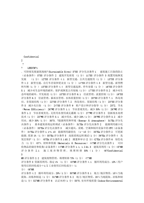
Confidential 2?? LEEDTM?1.可持续发展建筑场地?(Sustainable Sites) 8?SS 评分先决条件1 建筑施工污染的防止(必备条件) 8?SS 评分条件 2 建筑开发密度(1 分) 11?SS 评分条件 3 废置用地恢复发展(1 分) 12?SS 评分条件4.1 新型交通,公共交通使用(1 分) 13?SS 评分条件4.2 新型交通,自行车存放和更衣室(1 分) 14?SS评分条件4.3 新型交通,新型燃料车辆(1 分) 15?SS评分条件4.4 新型交通选择,停车容量(1 分) 16?SS评分条件5.1 减少对生态环境的破坏,保护或恢复公共绿地(1分) 17?SS评分条件5.2 减少对生态环境的破坏,开发痕迹(1分) 18?SS评分条件6.1 径流管理,流量控制(1分) 19?SS评分条件6.2 径流管理,暴雨水管理,水体质量控制(1分) 20?SS评分条件7.1 热岛效应,非屋面结构(1分) 22?SS评分条件7.2 热岛效应,屋面结构(1分) 23?SS评分条件8 减少光污染(1 分) 24?SS评分条件9 租户设计和评分指导(1 分) 25?2.节水(Water Efficiency) 26?WE评分条件1.1 节水景观美化,减少50%(1分) 26?WE评分条件1.2 节水景观美化,无饮用水使用或无灌溉(1分) 27?WE评分条件2 创新废水处理技术(1 分) 28?WE评分条件3.1 减少用水,减少20%(1分) 29?WE评分条件3.2 减少用水,减少30%(1分) 30?3.?能源利用和环境(Energy & Atmosphere) 31?EA评分先决条件1 基本建筑系统运转调试(必备条件) 31?EA评分先决条件2 能源利用最小化(必备条件) 33?EA评分先决条件3 减少通风、采暖、空调和制冷设备中的CFC(必备条件) 34?EA评分条件1.1-1.10 能源利用最优化(1-10 分) 35?EA评分条件2 可更新能源,更新1% (1 分) 38?EA评分条件3 高级系统运转调试(1 分) 39?EA评分条件4 臭氧层保护(1 分) 40?EA评分条件5.1 &5.2 测量和审计(2 分) 42?EA评分条件6 绿色电力(1 分) 43?4.材料和资源(Materials & Resources) 44?MR评分先决条件1 可回收物品的储存和收集(必备条件) 44?MR评分条件1.1, 1.2 &1.3 建筑再利用(1 分) 45?MR评分条件 2.1 施工废弃物管理,填埋转移50%(1 分)46?Confidential 3MR评分条件2.2 建筑废物管理,填埋转移75%(1 分) 47?MR评分条件3 资源再利用,指定1% (1 分) 48?MR评分条件4.1 循环利用成分,10%(用户使用后的回收成分+1/2工业使用后回收成分)(1分) 49?MR评分条件4.2 循环利用成分,20%(1分) 50?MR评分条件5.1 地方/地区物资,10%当地提取、冶炼和制造(1 分) 51?MR评分条件5.2 地方/地区物资,20%当地提取、冶炼和制造(1 分) 52?MR评分条件6 认证木材(1 分) 53?5.室内环境质量(Indoor EnvironmentalQuality) 54?EQ评分先决条件1 最低室内空气质量要求(必备条件) 54?EQ评分先决条件2 吸烟环境(ETS)控制(必备条件) 55?EQ评分条件1 空气监控系统(1 分) 56?EQ评分条件2 增加通风(1 分) 57?EQ评分条件3.1 施工室内空气境质量管理计划,施工期间(1 分) 59?EQ评分条件3.2 施工室内空气质量管理计划,入住前(EQ3.1附加分1分) 60?EQ评分条件4.1 低挥发性材料,黏合剂和密封剂(1分) 62?EQ评分条件4.2 低挥发性材料,油漆和涂料(1分) 63?EQ评分条件4.3 低挥发性材料,地毯(1分) 64?EQ评分条件4.4 低挥发性材料,合成木材(1分) 65?EQ评分条件5 室内化学制品和污染源控制(1 分) 66?EQ评分条件6 系统可控制程度,热舒适性(1分) 67?EQ评分条件7 热环境舒适程度-基本符合要求 (1分) 68?EQ评分条件8.1 日光和视野,75%空间日光照明(1分) 69?EQ评分条件8.2 日光和视野,90%空间视野(1分) 70?6.创新设计方法(Innovation In Design) 71?ID评分条件1 设计创新(最高4分) 71?ID 评分条件2LEED认证专业人员(1 分) 72??Confidential 4这份报告将由以下几部分组成:Confidential 5 LEEDTM由美国绿色建筑委员会(USGBC)颁发的LEEDTM绿色建筑认证是目前国际上最为先进和具实践性的绿色建筑认证评分体系。
leed 可持续发展的建筑场地 评估标准
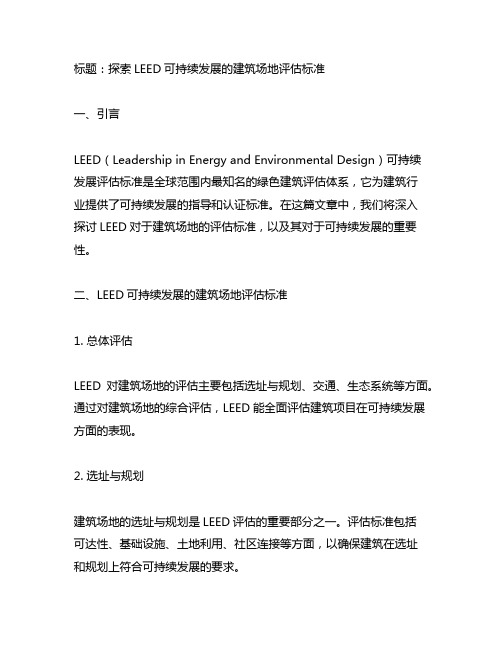
标题:探索LEED可持续发展的建筑场地评估标准一、引言LEED(Leadership in Energy and Environmental Design)可持续发展评估标准是全球范围内最知名的绿色建筑评估体系,它为建筑行业提供了可持续发展的指导和认证标准。
在这篇文章中,我们将深入探讨LEED对于建筑场地的评估标准,以及其对于可持续发展的重要性。
二、LEED可持续发展的建筑场地评估标准1. 总体评估LEED对建筑场地的评估主要包括选址与规划、交通、生态系统等方面。
通过对建筑场地的综合评估,LEED能全面评估建筑项目在可持续发展方面的表现。
2. 选址与规划建筑场地的选址与规划是LEED评估的重要部分之一。
评估标准包括可达性、基础设施、土地利用、社区连接等方面,以确保建筑在选址和规划上符合可持续发展的要求。
3. 交通LEED对于建筑场地的交通评估主要关注公共交通、车辆排放、非机动车交通等方面。
通过优化交通设计,降低交通对环境的影响,实现可持续发展的目标。
4. 生态系统生态系统评估包括对于植被覆盖、生物多样性、水循环等方面的考量。
LEED通过评估建筑场地的生态系统,鼓励保护自然环境,实现生态平衡。
5. 具体标准的阐述在具体的评估标准上,LEED考虑了建筑场地的地形、水文环境、土壤污染防治、景观设计等多个方面,以全面评估建筑项目的可持续性。
三、LEED对可持续发展的重要性LEED评估标准的制定旨在引导建筑行业朝着更加环保、节能、资源利用效率更高的方向发展。
它不仅提高了建筑的质量,也有助于改善环境质量、提升社区生活质量和降低运营成本。
四、个人观点和理解LEED可持续发展的建筑场地评估标准在建筑行业中起到了至关重要的作用。
它不仅帮助建筑业实现可持续发展,也提高了建筑的品质和竞争力。
LEED标准也唤起了人们对环境保护的意识,促进了社会的可持续发展。
五、总结与回顾LEED可持续发展的建筑场地评估标准在建筑行业中具有重要意义。
美国LEED绿色建筑认证系统在某项目中的应用分析

第4 0卷 第 1 1 期 2 2 0・ 2 0 1 4 年 4 月
山 西 建 筑
S HANXI ARC HI T E C T URE
V o 1 . 4 0 No . 1 1 A p r . 2 0 1 4
文章编号 : 1 0 0 9 - 6 8 2 5 ( 2 0 1 4 ) I 1 - 0 2 2 0 - 0 2
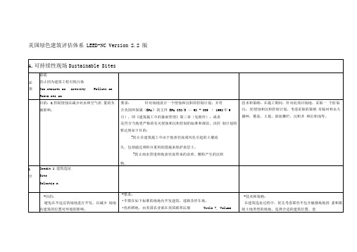
材料和资源
室 内环境质 量 创新与设计 本地优先
总 计
1 4
1 5 6 4
1 l 0
l 3
1 4 5 4
l 0 0
认证4 o 一 4 9 I 银奖5 0 — 5 9 I 金奖6 0 — 7 9 I 白金奖> 8 0
4 项 目调试及 测 量
表1 L E ED N 场址 节水
能源与大气
达到美 国绿色建筑 委员会 的 L E E D绿色建筑评估体系 的规定 。具 体来 说 , 扩建项 目旨在 减少 至少 5 0 % 的拆迁 垃圾 和 建设 填埋 垃
圾, 以及减少 7 5 % 目标水平 的材料 , 并且 达到绿 色建筑 评估 体 系
题都会导致土壤侵 蚀 , 比如 , 堆积废 弃沉 渣 、 临建 占用农 田等 等 。 我们应该利用生物学原理来 防止侵蚀 , 例如土壤加 固法和构 造控
制法 。
3 . 3 建 筑垃圾 清理计 划
该办公楼项 目已经确立 产生尽 可能少 的建 筑垃圾 的 目标 , 以
出评定 的 目的 、 要求 、 可 行 的技术及 策略 以及所 需提交 的文 档证 明的要求 , 其评定分值 和权重见表 1 L 3 J 。
1 L E E D 评分 方法
以L E E D — N C 3 . 0为例 , L E E D 通过 7个 方面对 建筑 项 目进行
LEED绿色建筑评估体系中文版
-目的:减少由于使用机动车造成的环境 污染和对土地开发的影响。
-要求:在商业或公共建筑中,给不少于5%的日常建筑用户
提供安全的自行车存放室并带有方便的沐浴和更衣设施(在建 筑的200码以内)。在住宅建筑中,给不少于15%的建筑住户
急管理局(FEMA确定;
•联邦政府或各州列岀的濒危保护生物栖息地;
•由美国联邦法典 40CFR, Parts 230-233 and Part22确
定的水域(包括湿地)100英尺范围内,及孤立湿地或由当地或 州法律法规确定的其他特殊土地,或者是在由州或当地的更严 格的法律法规确认的更大的范围内;
•地块在获得之前是属于公共公园的土地,除非公共公
-要求:在受污染的场地(根据美国试验与材料学会的文件
《ASTM E1903-97第二阶段 环境场地评估》确定)上进行开发
-技术和策略:在场地的选址过程中优先考虑褐地。 确认税收的优惠政策和财力成本的储备。制定和执行
到影响的场地,减少未开发场地所承受的 压力。
建设,或当地、州的政府机构的分类确认为褐地的场地。有效 的减缓场地的污染。
•优质耕地,由美国农业部在美国联邦法规Title7,Volume
-技术和策略:
在建筑选址过程中,优先考虑那些不包含敏感场地因 素和限制土地类型的场地。选择合适的建筑位置,设
6,Parts400to,W699,Section 657.5(引文7CFR657.5)中
确定;-
•地块标高在百年洪水标高以上5英尺以内,由联邦应
一个场地治理计划,使用如下一些策略:抽水处理、 生物反应器、土地耕种和现地整治。
1
分
LEED认证金奖与绿色三星认证对施工单位的细化要求

LEED认证金奖与绿色三星认证对施工单位的细化要求一、LEED认证为获得LEED认证金奖,请完成以下条款:定义含循环成分材料:生产过程中对回收材料再次利用,用来制造最终产品或产品部件的材料,包括“消费前废弃物”和“消费后废弃物”(根据ISO 14021定义)。
可循环成份的材料包括但不限于钢、石膏板、天花板瓦片、地毯和陶瓷砖等。
消费前废弃物:生产过程中转移出废物流的材料,但不包括同一过程中被再利用的材料,如通过再加工、再研磨或在同一过程中产生又被回收的残料(根据ISO 14021定义)。
消费前物料包括但不限于刨木花,复合板边角,木屑,碎片,蔗渣,葵花籽壳,核桃壳,不合格品,裁剪材料,打印废纸,超额发行的出版物和过时的库存。
消费后废弃物:家庭或商业、工业或其他团体作为产品的最终用户所产生的,无法再用于原用途的材料,包括从销售链上返回的材料(根据ISO 14021定义)。
消费后物料包括但不限于建筑施工碎片,从社区收集的材料,被丢弃的产品(例如,家具,橱柜及盖板)和城市维护废弃物(树叶,草坪和树枝修剪等)。
回收材料:原本将作为废弃物被处置,而实际操作中被回收并再次利用,在循环或生产过程中代替部分原材料的物质。
以下所有涉及到的施工方案及建筑施工材料参照标准均依照LEED CS 2009 Reference Guide执行。
1、防止水土流失(强制执行)1.1承包商针对项目现场实际情况,制定一套侵蚀与沉淀控制计划,旨在达到以下目标:✓防止因暴雨径流和侵蚀导致的水土流失。
✓防止因施工而导致的下水道或河道的沉积作用。
✓防止扬尘和大气中的颗粒物对周边环境的污染。
1.2计划采取措施●在现场适当的区域临时播种,种植一些生命力强的植物,并定期养护,从而有效控制土壤侵蚀●开挖的土方将临时堆放于场地空置处,并用彩塑布封盖,而且,待到基础施工完成后,该土方可以用于基础回填,以达到重新利用表层土的目的●在场地出入口处开挖一个沉淀池,从而沉淀因暴雨径流所带走的土体,水体经沉淀作用后,再排入市政污水管网,并定期清理池中的沉淀物,以大幅降低市政管网中的沉淀作用●在施工区域开挖并预埋临时排水管道,并将管道流向指向场区临时沉淀池,从而使管道中的因暴雨径流排至临时沉淀池●在排水井入口四周设置竖直的铁丝过滤网,将雨污水过滤后再排入临时雨水管网●在出入门处设置冲洗池,所有车辆在离开场地前,都要求清洗,除去附着于车身及轮胎上的尘土或其他污染物,冲洗后的水将就近排放至沉淀池●在开挖及基础施工期间,一旦出现因降雨而形成的积水,将立即组织人员将基坑中的积水抽出,并就近排入临时排水管道●制定定期洒水降尘制度,并由专人负责,以减少扬尘●施工现场路面及临时设施区域地面全部硬化处理,减少扬尘●水泥和其它易飞扬的细颗粒散体材料尽量安排库内存放,露天存放和运输时将严密遮盖,防止颗粒遗洒,以减少扬尘●为确保该计划的顺利执行,本工程项目组成立了专门负责小组,以明确各项分工.总之,上述措施将由项目经理和相关负责人监督落实,并定期检查执行情况,听取反馈意见,并根据实际情况调整相关策略.LEED协调员将会把措施的执行位置在图纸上反映出来,并以照片的形式记录和传递执行的进展和效果。
LEED金奖认证管理措施

LEED 金奖认证管理措施1LEED认证标准LEED是指由USCBC制定并推出的能源与环境建筑认证系统(Leadership in Energy & Environmental Design Building Rating System),是一一个自愿的以一致同意为基础的,目的在于发展高功能、可持续建筑物的标准。
LEED评分标准由以下五大系统组成:选址与建筑环境、节水、能源和大气污染、材料和资源、室内环境质量。
2LEED认证目标及总承包职责分析本工程体量大,总建筑面积30万m2。
本工程LEED认证目标为确保达到 LEED-CSv2009体系金级认证级别。
我单位将严格遵循招标文件要求,负责的设计和施工符合LEED金级认证并严格遵循LEED-CSV2009认证标准。
我单位凭借多个LEED认证项目的建设实施,在该类型项目的总包管理上积累了一定的经验,同时按照需要,培养了一批相关的管理型人才。
在LEED策划和管理方面,我单位完全有能力协助业主达到LEED认证要求,公司将选派1名具有LEED 项目认证管理经验的管理人员到场负责指导实施。
2.1总承包LEED认证职责总承包方在LEED认证实施过程中主要起配合协调作用,具体职责如下:(1)编制LEED策划及相关实施方案;(2)分解并明确各方在项目实施中LEED相关责任;(3)开展深化设计并与设计、监理、甲方及时沟通提出合理化建议;(4)项目实施中指导和检查各方相关工作;(5)与工程同步、整理收集认证需要相关资料;(6)定期向业主汇报工作进展;(7)提交LEED评审需要的文档、数据及资料。
2.2LEED认证总承包职责分解LEED认证相关要求包括:强制性要求;可持续发展建筑用地;节水;能源利用和环境;材料与资源;室内环境与质量;创新和设计。
这是一个长期多方合作的结果,主要负责单位包括:总承包单位、设计单位、调试单位、物业等,总承包单位的工作内容包括但不限于如下表所列:3LEED认证组织机构和认证流程项目选派参与过对LEED项目有管理经验的人员组成,并且邀请与我单位有合作经历的环境管理咨询公司不定期进行指导,以确保本项目的LEED金奖认证目标。
Leed认证评分

BTC LEED 要求目录汇总表1、可持续性的场地发展SSSS场地可持续发展施工污染防护2、能源和空气EAEAP1 建筑能源系统的基本调试EA认证3增强的调试3、材料和资源MRMRP1 Storage & Collection of Recyclables 可回收物品的储存和收集MR认证2.1施工废物管理:MR认证2.2施工废物管理:MR认证4.1循环利用率:10%(1分)MR认证4.2循环利用率:20%(1分)MR认证5.1本地材料:20%本地生产(1分)MR认证5.2本地材料:10%来自本地和当地生产(1分)MR认证6 使用经过认证的木材4、室内环境质量(EQ)EQC4.1 Low-Emitting Materials, Adhesives & Sealants 低挥发性材料,黏合剂和密封剂EQC4.2 Low-Emitting Materials, Paints & Coatings 低挥发性材料,油漆EQC4.3 Low-Emitting Materials, Carpet Systems 低挥发性材料,地毯EQC4.4 Low-Emitting Materials, Composite Wood & Agrifiber Products 低挥发性材料,合成木材1.可持续现场施工会对环境造成各种影响和污染,承包商/分包商要按照以下要求减少这些影响和污染。
SS前提1 避免施工污染目的;通过控制土壤污染,水道沉降与空气颗粒的生成来减少污染。
要求:制定符合2003EPA施工许可规定或当地侵蚀与沉降控制标准的侵蚀与沉降控制计划(ESC),两者以严格者为准。
计划要说明实现以下目标的具体办法:避免施工过程中雨水和风蚀造成的水土流失,包括储存表土再利用。
●避免雨水排放或收集造成的沉降。
●避免空气因灰尘与颗粒造成的污染。
提交文件:提交以下项目数据及资料,采用V2。
0文件格式:●提交项目图纸复印件,说明侵蚀与沉降控制措施的现场执行;●确认项目(NPDES)的遵循途径,遵守规定或当地浸蚀控制标准;●提供说明,关于为此项目实行的侵蚀与沉降控制措施。
土地整治工程专业英语

土地整治工程专业英语IntroductionLand reclamation, also known as land improvement or land rehabilitation, refers to the process of restoring and enhancing degraded land to a more productive state. This practice plays a vital role in sustainable development, as it helps to improve soil fertility, prevent erosion, and promote land utilization. In this document, we will explore the key concepts and terminology associated with land reclamation engineering.1. Land DegradationBefore delving into the details of land reclamation, itis crucial to understand the concept of land degradation. Land degradation refers to the deterioration of land quality, usually caused by natural processes or human activities. This degradation can result in reduced soil fertility, decreased biodiversity, and the loss of valuable ecosystem services. Land reclamation aims to reverse or mitigate land degradation and restore the land's productivity.2. Objectives of Land ReclamationThe primary objectives of land reclamation engineering are to improve soil quality, prevent soil erosion, and enhance land productivity. This is achieved through various techniques, such as soil amelioration, erosion control measures, and the introduction of appropriate vegetation. By restoring the land's fertility and stability, land reclamation helps create favorable conditions foragricultural activities, urban development, and ecological restoration.3. Techniques and MethodsLand reclamation engineering involves the implementation of various techniques and methods to restore and improve degraded land. These include:- Soil Amelioration: Soil amelioration aims to enhance soil fertility by adding organic matter, nutrients, and amendments to improve the soil's physical, chemical, and biological properties. This can be achieved through techniques such as soil aeration, nutrient supplementation, and pH adjustment.- Erosion Control: Erosion control measures are crucial in preventing soil erosion, which can lead to the loss of topsoil and reduced land productivity. Techniques such as contour plowing, terracing, and the implementation of erosion control structures help to minimize soil erosion and promote soil conservation.- Vegetation Restoration: The introduction of appropriate vegetation plays a crucial role in land reclamation. Selecting and planting suitable plant species can stabilize the soil, enhance water retention, and improve overall ecosystem resilience. Native plant species are often preferred to restore the original ecosystem and promote biodiversity.4. Case StudiesTo illustrate the application of land reclamation engineering, let's explore a few case studies:- Mining Sites: Land reclamation is often performed on mining sites after the extraction of mineral resources. By rehabilitating these areas and restoring the land's productivity, the negative environmental impacts of mining activities can be mitigated.- Urban Areas: In densely populated urban areas, land reclamation can help address land scarcity issues. By reclaiming and improving degraded land, urban spaces can be expanded, providing opportunities for development and infrastructure.- Coastal Areas: Coastal land reclamation is commonly employed to create new land for ports, airports, andresidential areas. By reclaiming land from the sea, coastal communities can expand and utilize land resources effectively. ConclusionLand reclamation engineering is a vital discipline that aims to restore and enhance degraded land for sustainable development. Through techniques such as soil amelioration, erosion control, and vegetation restoration, land reclamation helps improve soil quality, prevent erosion, and enhance land productivity. By understanding the concepts and practices associated with land reclamation, professionals in this field can contribute to the sustainable management of land resources.。
LEED BDC 概念中文

LEED v4 for BUILDING DESIGN AND CONSTRUCTIONIntegrative Process (IP )先决条件先决条件::整合项目规划及设计 (仅适于Healthcare )Requirements :在项目规划及与设计阶段开始时即采用交叉学科设计及决策方法。
至少保证下述流程:1) 业主项目需求文件业主项目需求文件((OPR )OPR 文件中列出基于经济、环境、社会三基线的健康使命声明。
包括保卫建筑住户、当地社区及地球环境健康的目标及策略,为建筑患者、看护及员工建立一个高效的康复环境。
2) 初步确定认证目标等级召开一个至少由四个关键的项目团队成员及业主或业主代表参加的LEED 会议,会议建立LEED 行动计划,至少包括: A , 确定要达到的LEED 认证等级(认证级,银级,金级,铂金级); B , 选择满足目标认证等级需要的LEED 得分点; C , 确定责任人以保证LEED 要求的先决条件及得分点满足要求。
3) 整合项目团队组织一个尽可能多的成员参加的项目整合团队,至少包含4个成员及业主或业主代表。
4) 设计专家会议设计专家会议((Charrette ) 至少4个小时会议,优化各专业绿色策略。
得分点得分点::整合流程整合流程((1分) Intent:通过早期项目系统交互分析达到建筑高效、低耗的目的。
Requirements:能源相关系统探索:评估以下内容相关的至少两项策略:场址情况:阴影、外部光照、硬景观、景观及相邻的场址条件;体量及朝向:受其影响的空调系统大小、能耗、照明及能源回收机会;基本的围护结构特性:隔热性、窗墙比、玻璃特性、阴影及窗户的可开启性;照明等级:内表面反射值、照明等级;热舒适性:热舒适范围选择;插座及工艺负荷需求:通过自动程序减少插座及工艺负荷;控制及运行参数:多功能空间、运行安排、人均面积、电子办公、减少建筑面积及预期的操作及运行。
土壤修复中英词汇

土壤修复中英词汇 Prepared on 22 November 2020英汉索引Aaboveground storage tank 地上储罐acceptable risk level 可接受风险水平*aeration zone 包气带air sparging 空气注入法air stripping 空气吹脱法ambient air of contaminated site 场地环境空气aquifer 含水层aquifuge 隔水层asbestos 石棉Bbackfill soil 回填土*bioattenuation 生物衰减biological remediation 生物修复biopiles 生物堆层法bioreactor 生物反应器*bioremediation 生物修复bioslurping 生物抽除法*biosparging 生物曝气法bioventing 生物通风法BTEX 苯系物buried depth of groundwater table 地下水埋藏深度Ccancer risk 致癌风险cancer slope factor 致癌斜率因子capillary zone 毛细带capping 帽封*carcinogenic potency factor 致癌强度系数case study 案例研究chemical oxidation 化学氧化法chemical remediation 化学修复*chlorinated diphenyl 氯化联苯circulating well 循环井法cleanup 清洁治理commercial land 商业用地community involvement 公众参与composting 堆肥法*condensed nuclear hydrocarbon 稠环烃confinement 限制construction completion 施工完成阶段construction landcontainment 围堵contaminant of concern 关注污染物contaminant transport model 污染物迁移模型contaminated site archive 污染场地档案contaminated site management 污染场地管理*contaminated site register 污染场地登记contaminated site report 污染场地申报contaminated site 污染场地cost-benefit analysis 成本-效益分析critical receptor 关键受体cyanide 氰化物Ddata collection 资料收集decision support 决策支持deep soil 深层土demonstration project for site remediation 场地修复示范工程dense non-aqueous phase liquid 高密度非水相液体detailed site environmental investigation 场地环境详细调查dioxin 二恶英Eecological receptor 生态受体ecological risk assessment 场地生态风险评估ecological risk 生态风险electrokinetic separation 电动分离法encapsulation 封装enclosure 围隔engineering acceptance monitoring 工程验收监测engineering control 工程控制environmental sensitive area 敏感环境区environmental site investigation 场地环境调查established technology 成型技术excavation and disposal/treatment 挖掘-处置/处理ex-situ remediation 异位修复ex-situ thermal treatment 异位热处理法exposure assessment model 暴露评估模型exposure assessment 暴露评估exposure concentration 暴露浓度exposure dose 暴露量exposure factor 暴露参数exposure frequency 暴露频率exposure pathway 暴露途径exposure period 暴露周期exposure scenario 暴露情景exposure 暴露Ffeasibility study for remediation 修复可行性研究*fused-ring aromatic compound 稠环芳烃Ggroundwater of contaminated site 场地地下水groundwater system 地下水系统groundwater table 潜水面Hhazard identification 危害识别hazard index 危害指数hazard quotient 危害商health risk assessment 场地健康风险评估health risk 健康风险heavy metal 重金属*hydraulic conductivity 水力传导系数hydraulic gradient 水力坡度Iincineration 焚烧indoor air 室内空气industrial land 工业用地innovative technology 新型技术*in-situ air stripping 原位吹脱法in-situ remediation 原位修复in-situ soil flushing 原位土壤冲涮法in-situ thermal treatment 原位热处理法inorganic pollutant 无机污染物interview 人员访谈*intrinsic remediation 内禀修复Jjudgemental sampling 专业判断法L*land treatment 土地处理landfarming 土地耕作法landfill 填埋land-use change 土地利用方式变更land-use classification 土地利用分类land-use planning 土地利用规划lead-based paint 含铅涂料life expectancy 期望寿命lifetime exposure 终生暴露light non-aqueous phase liquid 低密度非水相液体low temperature thermal desorption 低温热解吸法*low-temperature thermal volatilization 低温热挥发Mmaintenance of remediation 修复维护multiphase extraction 多相萃取法Nnatural and socio-economic information 自然和社会经济信息natural attenuation 自然衰减non-aqueous phase liquid 非水相液体non-cancer risk 非致癌风险Oon-site residual material 场地残余废弃污染物on-site test 现场检测organic pollutant 有机污染物outdoor air 室外空气Ppeer review 专家论证perched water 上层滞水permeability coefficient 渗透系数permeable bed 透水层permeable reactive barrier 可渗透反应墙persistent organic pollutant 持久性有机污染物pesticide 农药physical remediation 物理修复phytoremediation 植物修复polluter-pays principle 污染责任人付费原则pollution plume 污染扩散区polychlorinated biphenyl 多氯联苯polycyclic aromatic hydrocarbon 多环芳烃preliminary site environmental investigation 场地环境初步调查priority management site 优先管理场地Qqualitative risk assessment 定性风险评估quality assurance and quality control 质量保证和质量控制quantitative risk assessment 定量风险评估Rreceptor 受体recreational land 娱乐用地reference concentration 参考浓度*reference dose 参考剂量reference sampling site 对照采样点remedial technology 修复技术remedy construction 修复施工residential land 居住用地responsible party 污染场地责任人restriction on soil use 土地利用限制risk characterization 风险表征risk 风险S*safety factor 安全系数saturated zone 饱水带semivolatile organic compound 半挥发性有机化合物sensitive life stage 敏感生命阶段shallow soil 浅层土site activity information 场地生产活动相关记录site classification 场地分类site cleanup and remediation option 场地治理与修复方案site conception model 场地概念模型site environment 场地环境site environmental information 场地环境资料site environmental monitoring 场地环境监测site history investigation 场地历史调查site hydrogeological condition 场地水文地质条件site inspection 场地踏勘site investigation and assessment agency 场地调查评估机构site investigation monitoring 场地环境调查监测site monitoring for retrospective assessment 场地回顾性评估监测site remediation acceptance 场地修复验收site remediation monitoring 场地治理修复监测site remediation supervision 污染场地修复工程监理site risk assessment 场地风险评估site-specific parameter 场地特征参数site-use change information 场地利用变迁资料*soil bulk density 土壤容重soil density 土壤密度soil lithology 土壤岩性soil of contaminated site 场地土壤soil organic matter 土壤有机质soil pH 土壤 pHsoil porosity 土壤孔隙度soil property 土壤性质soil remediation 土壤修复*soil roasting 土壤煅焙soil screening value 土壤筛选值soil texture 土壤质地soil vapor extraction 土壤气相抽提法soil washing 土壤淋洗法soil water content 土壤含水量solidification/stabilization 固化/稳定化solvent extraction 溶剂萃取法stakeholder 利益相关方stratified sampling 分区布点法stratigraphic structure 地层结构supercritical water oxidation 超临界水氧化法surface soil 表层土surface water of contaminated site 场地地表水systematic random sampling 系统随机布点法systematic sampling 系统布点法Tthermal desorption 热解吸法*thermal stripping 热脱附thermal treatment 热处理法tiered investigation 分阶段调查total petroleum hydrocarbon 总石油烃toxicity assessment 毒性评估*treatment technology 处理技术Uuncertainty analysis 不确定性分析uncertainty factor 不确定性系数underground storage tank 地下储罐unsaturated zone 非饱水带V*vadose zone 渗流带vitrification 玻璃化作用法volatile organic compound 挥发性有机化合物Wwater table 地下水位。
Ground-vibration-due-to-dynamic-compaction_2006_Soil-Dynamics-and-Earthquake-Engineering
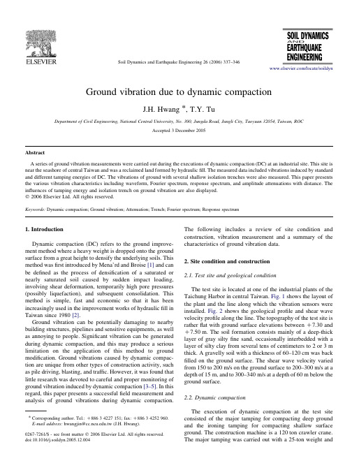
Ground vibration due to dynamic compactionJ.H.Hwang *,T.Y.TuDepartment of Civil Engineering,National Central University,No.300,Jungda Road,Jungli City,Taoyuan 32054,Taiwan,ROCAccepted 3December 2005AbstractA series of ground vibration measurements were carried out during the executions of dynamic compaction (DC)at an industrial site.This site is near the seashore of central Taiwan and was a reclaimed land formed by hydraulic fill.The measured data included vibrations induced by standard and different tamping energies of DC.The vibrations of ground with several shallow isolation trenches were also measured.This paper presents the various vibration characteristics including waveform,Fourier spectrum,response spectrum,and amplitude attenuations with distance.The influences of tamping energy and isolation trench on ground vibration are also displayed.q 2006Elsevier Ltd.All rights reserved.Keywords:Dynamic compaction;Ground vibration;Attenuation;Trench;Fourier spectrum;Response spectrum1.IntroductionDynamic compaction (DC)refers to the ground improve-ment method where a heavy weight is dropped onto the ground surface from a great height to densify the underlying soils.This method was first introduced by Mena’rd and Broise [1]and can be defined as the process of densification of a saturated or nearly saturated soil caused by sudden impact loading,involving shear deformation,temporarily high pore pressures (possibly liquefaction),and subsequent consolidation.This method is simple,fast and economic so that it has been increasingly used in the improvement works of hydraulic fill in Taiwan since 1980[2].Ground vibration can be potentially damaging to nearby building structures,pipelines and sensitive equipments,as well as annoying to people.Significant vibration can be generated during dynamic compaction,and this may produce a serious limitation on the application of this method to ground modification.Ground vibrations caused by dynamic compac-tion are unique from other types of construction activity,such as pile driving,blasting,and traffic.However,it was found that little research was devoted to careful and proper monitoring of ground vibration induced by dynamic compaction [3–5].In this regard,this paper presents a successful field measurement and analysis of ground vibrations during dynamic compaction.The following includes a review of site condition and construction,vibration measurement and a summary of the characteristics of ground vibration data.2.Site condition and construction 2.1.Test site and geological conditionThe test site is located at one of the industrial plants of the Taichung Harbor in central Taiwan.Fig.1shows the layout of the plant and the line along which the vibration sensors were installed.Fig.2shows the geological profile and shear wave velocity profile along the line.The topography of the test site is rather flat with ground surface elevations between C 7.30and C 7.50m.The soil formation consists mainly of a deep-thick layer of gray silty fine sand,occasionally interbedded with a layer of silty clay from several tens of centimeters to 2or 3m thick.A gravelly soil with a thickness of 60–120cm was back filled on the ground surface.The shear wave velocity varied from 150to 200m/s on the ground surface to 200–300m/s at a depth of 15m,and to 300–340m/s at a depth of 60m below the ground surface.2.2.Dynamic compactionThe execution of dynamic compaction at the test site consisted of the major tamping for compacting deep ground and the ironing tamping for compacting shallow surface ground.The construction machine is a 120ton crawler crane.The major tamping was carried out with a 25-ton weightandSoil Dynamics and Earthquake Engineering 26(2006)337–346/locate/soildyn0267-7261/$-see front matter q 2006Elsevier Ltd.All rights reserved.doi:10.1016/j.soildyn.2005.12.004*Corresponding author.Tel.:C 88634227151;fax:C 88634252960.E-mail address:hwangjin@.tw (J.H.Hwang).a falling height of 20m,and the iron (surface)tamping used a 12-ton weight and a falling height of 5m.The major tamping was executed in three phases.The impact number of each tamping point was 25,25and 15,respectively,in the three phases.Furthermore,the 25tampings in the first and second phases were carried out in to two passes with 15and 10tampings.The spacing of tamping points in the first and second phases was 10m apart in a square arrangement.In the third phase,the tamping point is located in between the tamping points of the first and second phases and with the spacing of 7.05m.The iron tamping covered the whole site and it was conducted in two rounds.Construction vibration measurement was carried out only for the major tamping because its tamping energy is far higher than the iron tamping,thus having a greater influence to the surrounding structures.3.Vibration measurement3.1.Equipment for vibration measurementThe equipment for measuring ground vibration included velocity sensors,connectable,50m long electric cables,anda recording and storing system.A force balanced type VSE-15D velocity sensor,manufactured by Tokyo Dynamic Test Company,was used.The frequency range of the sensor is 0.1–70Hz.The measurement ranges of velocity and acceleration are G 10kine (cm/s)and G 2000gal (cm/s 2),respectively.The sensitivities of the velocity and acceleration sensors were 1V/kine and 5mV/gal,and the resolutions were 100m kine for velocity and 300m gal for acceleration.The recording,storing and data processing system was a SPC-35F system,with eight channel data logging and an amplifier system connected to a PC-98notebook computer for storing and processing data.The resolution of the A/D interface was 16bits and the maximum sampling rate was 1000Hz.yout of measurement without isolation trench The purpose of this layout is to measure the ground vibrations at various distances from the tamping point under standard and other tamping energy conditions.A 25-ton weight and four falling heights of 20,15,10and 5m were used to create different tamping energies.The tamping was executed nine times for each falling height and the groundvibrationsFig.1.The layout of the plant and the alignment of velocity sensors in the test site.J.H.Hwang,T.Y.Tu /Soil Dynamics and Earthquake Engineering 26(2006)337–346338were also measured nine times.Fig.3presents the layout of the measurement.The positions of sensor stations were arranged in accordance with the experience of vibration attenuation of pile driving.The closet station was 10m distant from the tamping point along the line of measurement.Every station had three velocity sensors,which measure vertical,radial and tangential velocity histories,respectively.yout of measurement with isolation trenchThis layout was designed to investigate to know the vibration isolation effect of shallow trench on the surface ground vibration induced by dynamic compaction.Fig.4presents the profile layouts of the measurements.There were three shallow open trenches.They were all 3m deep and 1m wide.The first,second and third trench was 20,15and 10m long and they were located at 15–25m,85–95m and 140–150m distant from the tamping point for understanding the isolation effect of the trench at near,medium and far distances.The vibration sensor in the back of the trench was installed at 4m distant from the edge of the trench.This location was beyond the range of ground surface that bounded by the vertical cut face of the trench and the 458line passing through the bottom corner of the trench (as shown in Fig.4).Although the vibration isolation effect is more notable when the trench is closer to the building structure,the soil mass inside that range is prone to collapse to result in possible damages of building foundations.Therefore,it is impractical to install sensor too close to the trench.For the purpose of comparison,the vibration measurement without trench was conducted beforethe trench was excavated.The standard tamping energy with a 25-ton weight and a 20m falling height was used in these measurements.For each of the layouts,tamping and vibration measurement were performed 10times.4.Data analysis4.1.Typical vibration wave formFig.5shows the recorded vertical,radial and tangential velocity-time histories,respectively,at various distances from the tamping point under standard tamping energy.It is obvious that the vertical and radial wave forms are typical vibration responses under a heavy impact,however,the tangential wave form was more complicated.The high frequency peaks in the front part of the wave forms attenuate quickly with distance in all three directions,but the low frequency peaks in the rear part of the wave forms attenuate more slowly with distance.Fig.6shows a comparison of the velocity wave forms in three directions at 10m distance from the tamping point.We can observe that the vertical and radial velocity amplitudes are far greater than that of tangential direction.By integration from velocity histories,a comparison of displacement wave forms is shown in Fig.7.Obviously,the vertical and radial displace-ment wave forms show the ground response that was suddenly pressed downward and then rebounded upward and finally restored to its original position.The tangential displacement history is more complicated than the other two directions.As compared with the analytical solution of radial displacement wave form provided by Lamb [6]in the samefigure,Fig.2.The geological profile and shear wave velocity along the line of measurement.J.H.Hwang,T.Y.Tu /Soil Dynamics and Earthquake Engineering 26(2006)337–34633910m 10m 15m65m 60mFig.4.The layout of the measurement with isolationtrench.10m 10m 10m 5m 20m 40m 5m 60mFig.3.The layout of the measurement without isolation trench.J.H.Hwang,T.Y.Tu /Soil Dynamics and Earthquake Engineering 26(2006)337–346340the measured wave form is very similar to the theoretical one.Fig.8displays the particle paths in the plane of vertical and radial directions.The paths of particle motions during the first half cycle look like flat ellipses rotating in counterclockwise direction.The above characteristics of surface ground motions are almost reproducible in any vibration record of different tamping.4.2.Fourier and response spectraFig.9shows the Fourier amplitude spectra of velocity records in vertical,radial and tangential directions at various distances from the tamping point under standard tamping energy.The shapes of the spectra at different distances are similar in the same direction.The spectrum at near distance has a more conspicuous predominant frequency band and a corresponding peak than the one at far distance.This is due to energy focusing at near distance and multiple refractions and reflections of stress wave between soil layers.The primary frequency of vertical vibration is in the range of 10–20Hz,while the radial vibration has two primary frequencies,one is 3–4Hz and the other is 12–13Hz.The whole vibration frequency contents are primarily in the range of 0–40Hz for all three directions.Fig.10is a comparison of Fourier spectra inthree directions.Obviously,they are quite different,especially for the tangential direction.The spectrum in radial direction has a low frequency peak.Fig.11shows the normalized acceleration response spectra in vertical,radial and tangential directions at various different distances from the tamping pointvertical directionradial direction tangential direction-10-50510v e l o c i t y (c m /s e c )v e l o c i t y (c m /s e c )v e l o c i t y (c m /s e c )v e l o c i t y (c m /s e c )v e l o c i t y (c m /s e c )v e l o c i t y (c m /s e c )distance=10m-10-50510distance=20m-10-50510distance=30m-10-50510distance=60m-10-50510distance=100m -10-50510-10-50510v e l o c i t y (c m /s e c )v e l o c i t y (c m /s e c )v e l o c i t y (c m /s e c )v e l o c i t y (c m /s e c )v e l o c i t y (c m /s e c )v e l o c i t y (c m /s e c )v e l o c i t y (c m /s e c )v e l o c i t y (c m /s e c )v e l o c i t y (c m /s e c )v e l o c i t y (c m /s e c )v e l o c i t y (c m /s e c )v e l o c i t y (c m /s e c )-10-50510-10-50510-10-50510-10-50510-10-50510distance=165mdistance=10mdistance=20mdistance=30mdistance=60mdistance=100mdistance=165m-2-1012012345012345time (sec)012345time (sec)012345time (sec)12345time (sec)012345time (sec)012345time (sec)012345time (sec)012345time (sec)012345time (sec)012345time (sec)012345time (sec)012345time (sec)012345time (sec)time (sec)012345time (sec)012345time (sec)01234512345time (sec)time (sec)distance=10m-2-1012distance=20m-2-1012distance=40m-2-1012distance=60m-2-1012distance=100m -2-1012distance=165m(a)(b)(c)Fig.5.The three velocity histories at different distances under standard tampingenergy.1 1.52 2.53time (sec)v e l o c i t y (c m /s e c )Fig.6.The comparison of the velocity wave forms in three directions at 10m distance from the tamping point.J.H.Hwang,T.Y.Tu /Soil Dynamics and Earthquake Engineering 26(2006)337–346341–0.4–0.3–0.2–0.100.10.20.30.4–0.4–0.3–0.2–0.100.10.20.30.4R-dir (cm)V -d i r (c m )Fig.8.The particle paths in the plane of vertical and radial directions.510152025303540frequency (Hz)F o u r i e r a m p l i t u d e (k i n e -s e c )F o u r i e r a m p l i t u d e (k i n e -s e c )F o u r i e r a m p l i t u d e (k i n e -s e c )frequency (Hz)0510152025303540frequency (Hz)Fig.9.The Fourier amplitude spectra in vertical,radial and tangential directions at various different distances under standard tampingenergy.0.40.80510152025303540frequency (Hz)F o u r i e r a m p l i t u d e (k i n e -s e c )Fig.10.A comparison of the Fourier spectra in three directions.Lamb's Solutionvertical direction–0.4–0.200.20.4di s p l a c e m e n t (c m )distance=10mradial direction–0.4–0.200.20.4d i s p l a c e m e n t (c m )distance=10mtangential direction–0.0500.0501234012341234time (sec)time (sec)time (sec)d i s p l a ce m e n t (c m )distance=10mPSRayleighr (r,0,t)(a)(b)(c)(d)Fig.7.A comparison of displacement wave forms in three directions.J.H.Hwang,T.Y.Tu /Soil Dynamics and Earthquake Engineering 26(2006)337–346342under standard tamping energy.The shapes of spectra are similar in all directions.The spectral value in the range of shorter period at near distance is greater than that at far distance,but the spectral values of longer period at near distance is lower than that at far distance.All the normalized peak spectral values (S a /g )are less than 4.0.4.3.Attenuation of PGV and PGA with distanceFigs.12and 13show the attenuation relationship of PGV and PGA with distance in all three directions during continuous nine tampings under standard tamping energy.It is observed that the attenuation relationships of different tamping cases are very close and vibration characteristic of dynamic compaction seems to be reliably reproducible.The average attenuation relationships in three directions are plotted in Fig.14.We found that the vertical and radial vibrations are greater than the tangential vibration for near distance.The attenuation rate with distance in radial direction is the highest,the vertical direction is a little smaller and the tangential direction is the lowest.For far distance (R 100m),vibration values in three directions are almost the same.A comparison of the above attenuation relationship with that deduced from vibration monitoring of diesel pile driving at the same test site is shown in Fig.15.It was found that dynamic compaction has a greater vibration but a slightly faster attenuation rate with distance than diesel pile driving.4.4.Influence of different tamping energyFour falling heights of 20,15,10,and 5m were used to investigate the influence of tamping energy on ground0.1110Period (sec)S a /g0.1110Period (sec)S a /g0.1110Period (sec)S a /gFig.11.The normalized response spectra in vertical,radial and tangential directions at various different distances under standard tampingenergy.0.010.1110distance(m)P G V (c m /s e c )0.010.1110distance(m)P G V (c m /s e c )0.010.1110110100100011010010001101001000distance(m)P G V (c m /s e c )Fig.12.The attenuation relationship of PGV with distance in all three directions continuous nine tampings under standard tamping energy.J.H.Hwang,T.Y.Tu /Soil Dynamics and Earthquake Engineering 26(2006)337–346343vibrations.Fig.16presents the attenuation relationships of PGV in vertical and radial directions under different falling heights.We found that the higher the tamping energy,the greater the vibration,and the faster the attenuation rate.Fig.17is the comparison of vertical and radial Fourier spectra at 10m distance to the tamping point under different falling heights.It can be seen that the spectral shapes of different energy are similar,however,a higher energy causes a more distinct peak spectral value and a more clear predominant frequency.For falling heights of 15and 20m,the differences of attenuation relationship and spectral shape are small.This seems to indicate the absorbing capacity of the ground for storing vibration energy may have a limit.When the falling height is higher than a certain height limit,the induced vibrations have no significant difference.We guessed that the redundantpotential energy may be consumed to create a more deeper tamping hole.The falling height limit seems to be about 15m in this study.Fig.18exhibits the comparison of vertical and radial response spectra at 10m distance from the tamping point under different falling heights.It reveals that the average spectral shapes for different energies are rather close and most of spectral peaks occur in the range of structural period less than 0.15s.0.0010.010.1110P G A (g )0.0010.010.1110P G A (g )0.0010.010.11101101001000distance(m)1101001000distance(m)1101001000distance(m)P G A (g )Fig.13.The attenuation relationship of PGA with distance in all three directions continuous nine tampings under standard tampingenergy.0.010.11101101001000distance (m)1101001000distance (m)P G V (c m /s e c )0.0010.010.1110P G A (g )Fig.14.The average attenuation relationships in three directions.1101001000distance(m)P G V (c m /s e c )Fig.15.A comparison of the PGV attenuation relationships of DC and diesel pile driving.J.H.Hwang,T.Y.Tu /Soil Dynamics and Earthquake Engineering 26(2006)337–3463444.5.Influence of shallow isolation trenchFig.19shows the average attenuation relation of PGV in vertical direction with and without isolation trench under standard tamping energy.Three types of trench arrangement are shown in Fig.4.We cannot observe any significant difference in attenuation relations between the cases with and without trench from the arithmetic plot in Fig.19.The same observation was also obtained for the Fourier and response spectra.It could be concluded that the shallow trench seems to nearly have no isolation effect on the ground vibration induced by dynamic compaction for the layout of measurement used in this study.5.ConclusionBased on the study,the following conclusions can be drawn.1.The ground vibration induced by dynamic compaction approximates a one cycle impulse wave.All the vibration durations are within 0.1–0.3s,among which,the vertical vibration duration is the shortest,the longest0.010.1110P G V (c m /s e c )1101001000distance(m)1101001000distance(m)P G V (c m /s e c )Fig.16.The attenuation relationships of PGV in vertical and radial directions under different falling heights.0.20.4frequency (Hz)frequency (Hz)F o u r i e r a m p l i t u d e (k i n e -s e c )F o u r i e r a m p l i t u d e (k i n e -s e c )Fig.17.The comparison of vertical and radial Fourier spectra at 10m distance to the tamping point under different fallingheights.0.11100.20.40.60.81Period (sec)Period (sec)S a /g0.1110S a /gFig.18.The comparison of vertical and radial response spectra at 10m distance to the tamping point under different falling heights.J.H.Hwang,T.Y.Tu /Soil Dynamics and Earthquake Engineering 26(2006)337–346345is the radial direction,and the tangential direction is in between.The wave form is similar to the analytical solution for an impulse load on a elastic half-space and nearly repeatable during every tamping.2.The shapes of Fourier amplitude spectra at different distances are similar in the same direction.The spectrum at near distance has a more conspicuous predominant frequency band and a corresponding peak than the one at far distance.This is due to energy focusing at near distance and multiple refractions and reflections of stress wave between soil layers.The primary frequency ofvertical vibration is in the range of 10–20Hz,while the radial vibration has two primary frequencies,one is in the range of 3–4Hz and the other is in the range of 12–13Hz.This primary frequency is slightly lower than that of diesel pile driving at the same test site.The Fourier spectral shapes in different directions at the same distance are considerably different.3.The vibration peaks in vertical and radial directions are roughly about the same and notably greater than the peak in tangential direction,but at a distance far than 100m,the vibration peaks of the three directions become about the same.This is due to the attenuation rate with distance in radial direction is the highest,the vertical direction is a little smaller,and the tangential direction is the lowest.The vibration peak and its attenuation with distance in dynamic compaction are larger than those in diesel pile driving at the same test site.4.The higher the tamping energy,the greater the vibration,and the faster the attenuation rate.The storing capacity of the ground for vibration energy seems to have a limit.When the falling height is higher than a certain height limit,the influence of tamping energy on the induced vibrations becomes insignificant.5.The shallow trench seems to have no isolation effect on the ground vibration induced by dynamic compaction for the layout of measurement used in this study.AcknowledgementsThis research was sponsored by RSEA Company.The author would like to extend his sincere gratitude to RSEA for the support.References[1]Menaa´rd L,Broise Y.Theoretical and practical aspects of dynamic consolidation.Geotechnique 1975;25(1):3–18.[2]Pan J,Hwang ZM.Soil densification by dynamic consolidation forformosa heavy industries corp.Sino Geotech 1995;51:35–50.[3]Skipp BO,Barkley JS.Ground vibration from impact.In:Proceedings ofthe ninth international conference on soil mechanics and foundation engineering,Tokyo,Japan,vol.2;1977.p.397–401.[4]Mayne PW.Ground vibrations during dynamic compaction.In:Gazetas G,Selig ET,editors.Vibration problems in geotechnical engineering.Special publication of ASCE;1985.p.247–65.[5]Fang HY,Ellis boratory study of ground response to dynamicdensification.Frity Engineering Laboratory Report No.462-06,Lehigh University,Bethlehem;1983.[6]Lamb H.On the propagation of tremors over the surface of an elastic solid.Philos Trans R Soc Lond 1904;A203:1–42.0246810distance(m)distance(m)distance(m)P G V (c m /s e c )0246810P G V (c m /s e c )0246810040801201602000408012016020004080120160200P G V (c m /s e c )Fig.19.The average attenuation relation of PGV in vertical direction with and without isolation trench under standard tamping energy.J.H.Hwang,T.Y.Tu /Soil Dynamics and Earthquake Engineering 26(2006)337–346346。
LEED绿色认证 Requirement for Main Contractor (version1)
LEED Requirement for
Main Contractor
1
[SS prerequisite 1] - Construction Activity Pollution Prevention 侵蚀、沈淀 / 污水处理 Requirement 要求
Create and implement an erosion and sedimentation control plan for all construction activities associated with the project. The plan must describe the measures implemented to accomplish the following objectives: 为与项目相关联的所有建筑活动建立和实施一个处理侵蚀及沉淀的计划。该计划必须描述所实行 之措施以实现下目标︰ To prevent loss of soil during construction by stormwater runoff and/or wind erosion, including protecting topsoil by stockpiling for reuse. 为防止土壤被雨水径流和/或风所侵蚀,包括保护已被储存的表土以作为再利用土壤。 To prevent sedimentation of storm sewers or receiving streams. 为防止雨水下水道流或水流沉淀。 To prevent pollution of the air with dust and particulate matter. 为防止灰尘和颗粒物污染空气。 Apart of the local standard, develop an erosion and sedimentation control drawing and/or a written erosion and sedimentation control plan with specifications that detail the erosion and control best management practices used on the project site. 除了地方标准 - 建筑施工安全检查标准(JGJ59- 99)要求等,请提供侵蚀和沉淀控制图纸和/或 侵蚀和沉淀控处理规格,详细说明侵蚀控制的最佳措施。 Over the course of site work activities, document implementation of the erosion and sedimentation control plan through date-stamped photos, inspection logs or reports, descriptions of corrective action in response to problems, etc. 于工地实施工作期间,需提供有效资料以证明已采取的措施能符合侵蚀及污水处理的标准。文件 包括通过日期戳记的照片,检查记录或报告,描述有关纠正问题的行动等。
LEED认证
第1章通过LEED-CS认证的保证措施1.1LEED-CS认证目标本工程中的a1、a2、a5、a6必须获得LEED认证级的证书。
1.2我司对LEED-CS认证的理解LEED认证,由美国绿色建筑委员会(USGBC)颁发的LEED绿色建筑认证是目前国际上最为成熟和最具实践性的绿色建筑认证评分体系。
该系统将帮助项目团队明确绿色建筑的目标,制订切实可行的设计策略,使项目在能源消耗、室内空气质量、生态、环保等方面达到国际认证体系LEED的指标和标准,为项目今后的用户提供高质量、低维护、健康舒适的办公和居住环境。
LEED评分标准由以下五大系统组成:选址与建筑环境、节水、能源和大气污染、材料和资源、室内环境质量。
该评估体主要涵盖新建建筑、既有建筑、商业装修、建筑结构、住宅、商业开发等方面的LEED认证。
LEED认证过程中,在施工阶段还具体而言包含以下几个方面的内容:水土保持和泥沙淤积控制:避免土地水土流失的景观设计包括增加贫瘠土量,种植特定的植物固土等。
增加的景观可能需要养护,就会增加建筑运行成本。
使用本地植物既可以减少灌溉用水量,又无需太多的养护成本。
减少施工过程中对生态环境的破坏:为项目场地设计总体规划,调查现有的生态系统并确定场地的土壤类型。
为现有的水资源、土壤条件、生态系统、野生动植物走廊、植被和绿化情况作详细记录,标明所有可能对自然环境造成危害的因素。
考虑待开发项目对现有自然和非自然系统可能产生的影响,以及尽量减少负面影响的措施。
施工废弃物管理:制定并实施废弃物管理计划,该计划中应明确解构和回收材料的机会、推荐采用的回收方法、合法的可回收物品运输和加工单位、以及这些加工后的产品的可能市场。
计划中应该包含回收、筛选和再利用材料的估计成本,还应该有针对性的提到减少材料使用的问题。
施工期间及入住前室内空气质量管理:该评分条件与施工人员的操作有关。
无论项目采取何种操作方式,不管是设计/招标/施工,还是设计/施工,总承包商都必须在施工过程中实施IAQ管理计划。
浅谈建筑绿色施工及LEED认证
浅谈建筑绿色施工及LEED认证作者:曾江巨舟来源:《城市建设理论研究》2012年第32期摘要:LEED国际绿色建筑认证体系是由美国绿色建筑协会建立并推行的“绿色建筑评估体系”。
在建筑施工阶段LEED-NC实施的工作内容:在充分理解LEED-NC中每个得分点基础上,最终取得LEED认证。
其中包括侵蚀和沉积控制、循环成分材料及本地材料控制、低挥发材料的选择控制等。
关键词:建筑绿色绿色施工LEED认证中图分类号:TV52 文献标识码:A 文章编号:引言随着环境保护、可持续发展和科学发展观理念的提出,人类在推进经济发展的同时越来越重视经济发展与资源、环境相协调,保护和增强发展的可持续性。
LEED被认为是其中最完善、最具影响力的评估标准,在全球范围内被广泛使用。
目前,LEED在我国建筑领域的应用仍处于起步阶段,必须结合我国建筑发展的实际情况,合理有效地利用LEED评价体系,从中寻找我国绿色建筑评价体系的发展之路。
1.我国的绿色建筑评价体系我国绿色建筑评价体系的建设起步较晚,目前还处于初期阶段,缺乏实践经验,许多相关的技术研究领域还是空白,相关评价体系的拟定基本都借鉴国外经验。
例如,2001年9月底建设部科技委员会公布的我国生态住宅技术标准《中国生态住宅技术评估手册》,其指标体系主要参考了LEED绿色建筑评价体系2.0版本,同时也融合我国《国家康居示范工程建设技术要点》等法规的有关内容;2003年8月由清华大学、中国建筑科学研究院等九家科研院所联合推出《绿色奥运建筑评估体系》,则参考了日本的CASBEE绿色建筑评价体系。
现今,中国建筑领域通行的是2006年6月1日由建设部和科技部发起施行的《绿色建筑评价标准》,是我国第一部从住宅和公共建筑全寿命周期出发,多目标、多层次,对绿色建筑进行综合性评价的推荐性国家标准。
评价体系由节地与室外环境、节能与资源利用、节水与水资源利用、节材与材料资源利用、室内环境质量和运营管理6类指标组成。
LEED认证实施方案
LEED认证实施方案LEED(Leadership in Energy and Environmental Design)是一种广泛认可的绿色建筑认证体系,旨在鼓励可持续发展和绿色建筑实践。
LEED认证的实施方案是一个系统化的方法,用于指导建筑项目在各个方面达到可持续性和环境友好的标准。
以下是一个简要的LEED认证实施方案的概述,其中包括关键步骤和实施方法。
1.项目计划和准备阶段:这个阶段的关键目标是确保项目的成功实施和LEED认证的达成。
在这个阶段,项目团队需要建立一个明确的目标和范围,确定适用的LEED评估标准,以及制定一个详细的计划,并分配任务和责任。
2.设计阶段:在这个阶段,项目团队需侧重于设计师和工程师的合作,以确保建筑设计符合LEED认证的标准。
这包括选择合适的建筑材料和技术,优化建筑空间使用效率,提高能源效益,减少水资源消耗等。
此外,项目团队还需进行能源模拟、材料选择和环境影响评估。
3.施工阶段:在这个阶段,项目团队需要确保施工期间的可持续性和环境友好操作。
这包括建立一个有效的废物管理和回收计划、监督施工过程中的能源和水资源使用、确保室内环境质量符合标准等。
4.运营及维护阶段:在这个阶段,项目团队需要确保建筑物的可持续性和环境友好性在使用和维护过程中得到持续的保持。
这包括建立一个定期的设备维护计划、监督能源和水资源的消耗、优化室内环境质量等。
此外,项目团队还需建立一个有效的监测和报告体系,以跟踪建筑物的性能和改进潜力。
5.LEED认证申请和评估:在设计和建设过程完成后,项目团队需要准备和提交LEED认证申请。
这包括收集必要的文件和证明材料,包括设计文件、施工记录、能源消耗数据等。
LEED认证委员会将对申请进行评估,并根据LEED评分系统的要求,评估项目是否符合相关标准。
6.LEED认证和持续改进:一旦项目通过了LEED评估,认证委员会将授予LEED认证的标志。
然而,这并不意味着工作的结束,项目团队还需要保持对建筑物的监测和改进,并持续追求更高的可持续性和环境友好性。
- 1、下载文档前请自行甄别文档内容的完整性,平台不提供额外的编辑、内容补充、找答案等附加服务。
- 2、"仅部分预览"的文档,不可在线预览部分如存在完整性等问题,可反馈申请退款(可完整预览的文档不适用该条件!)。
- 3、如文档侵犯您的权益,请联系客服反馈,我们会尽快为您处理(人工客服工作时间:9:00-18:30)。
XXXX Business Center
Phase 1
XXXX商业园(一期)
Foundation Construction 桩基及基坑围护工程
Erosion & Sediment Control Plan 土壤侵蚀和沉积控制计划
XXXX Engineering Corporation
July 2013
XXXX工程总公司
2013年7月
目录
第一章工程概况PROJECT DESCRIPTION (1)
第二章方案目标OBJECTIVE (2)
第三章组织管理图及相关责任ORGANISATION AND RESPONSIBILITY OF PERSONNEL (3)
3.1组织机构图O RGANIZATION C HART (3)
3.2岗位职责R ESPONSIBILITIES (4)
第四章土壤侵蚀控制计划EROSION AND SEDIMENTATION CONTROL MEASURES (5)
4.1施工围墙C ONSTRUCTION F ENCES (5)
4.2沉淀池S EDIMENT B ASIN (5)
4.3车辆清洗台V EHICLE C LEANING S TATION (6)
4.4临时覆盖T EMPORARY C OVERAGE (6)
4.5临时排水沟T EMPORARY D RAINS (7)
4.6地面硬化S URFACE H ARDENING (8)
4.7扬尘控制D UST C ONTROL (8)
第五章土壤侵蚀控制执行流程IMPLEMENTATION & MONITORING (9)
第六章维护保养计划MAINTENANCE (10)
第七章文件记录DOCUMENTATION (10)
附录APPENDIX (12)
第一章工程概况PROJECT DESCRIPTION
XXXX Business Center Phase 1 project is funded by XXXX Real Estate Development Co.,Ltd, located in XX District, Shanghai City, the east is XX road, the north is the rail line 12 XX station ( construction ), the south and west are planning roads.The project consists of two 16-storey office building, two 7-storey office building, one 2-storey commercial center and 2-storey underground garage. Office buildings are frame - core tube structure, the 16-storey office building height of about 80m, the 7-storey office building height of about 38m, the business center is 2-storey frame structure, height of about 15m, entire district were set up 2-storey basement, frame structure,foundation depth is 10.2-11.1m.
XXXX商业园(一期)工程项目由XXXX房地产开发有限公司开发建设,位于上海市XX区,东侧为XX路,北临轨道交通12号线XX路站(施工中),南侧和西侧均为规划道路。
项目由2栋16层办公楼、2栋7层办公楼、1栋2层商务中心和2层地下车库组成。
办公楼建筑均为框架-核心筒结构,16层办公楼建筑高度约80米,7层办公楼建筑高度约38米;商务中心为2层框架结构,建筑高度约15米;整个地块均下设2层地下室,框架结构,基础埋深为10.2-11.1米。
All the buildings adopt pile foundation, our company is mainly responsible for foundation construction, specific construction content
includes: Residual pile extraction, Rile foundation engineering, Underground continuous wall, Three-axis mixing pile and Soil reinforcement.
各拟建建筑物拟采用桩基础,我司主要承担桩基及基坑围护工程,具体施工内容包含:残留桩拔除、桩基础工程(包括工程桩、试锚桩、桩基检测等)、围护桩、立柱桩及格构柱、地下连续墙、三轴搅拌桩止水帷幕、土体加固(包括坑底、坑内及深坑加固等)。
第二章方案目标OBJECTIVE
Erosion control, reduce the negative influence on water and air quality, prevent the pollution caused by construction. According to the contract documents, the ultimate goal is LEED-certified "Gold".
控制土壤侵蚀,减少对水和空气质量的负面影响,防止由建筑施工引起的污染。
根据合同文件,最终目标为获得LEED认证“金奖”。
The E&S control plan must conform to the erosion and sedimentation requirements of the 2003 EPA Construction General Permit or local standards and specification requirements, subject to more stringent party. And need to describe the measures to meet the following objectives.
制定并实施土壤侵蚀和沉积控制计划,使其符合2003版环境总署总体施工许可的要求或者本地标准及规范要求,以更加严格一方为准。
并且需要就为满足以下几个目标所采取的措施进行说明:
➢Clearly describe and identify the potential erosion and sedimentation on site, their risk and the corresponding control measures.
清楚地说明及指出现场的潜在水土流失及沉积问题,风险程度及相应的控制措施;
➢Prevention of loss of soil during construction by storm water runoff and/or wind erosion, including protecting topsoil by stockpiling for reuse.
防止施工期间雨水径流及/或风力侵蚀造成土壤流失,包括通过储存再利用来保护表层土壤;
➢Prevention of sedimentation of storm sewer or receiving streams.
防止雨水管或排污河的沉降;
➢Prevention of pollution of air with dust and particulate matter.
防止粉尘颗粒等污染空气;
第三章组织管理图及相关责任ORGANISATION AND RESPONSIBILITY OF PERSONNEL
3.1组织机构图Organization Chart
In the process of soil erosion and sediment control,will be unified management by project manager, the organization chart are as follows: 执行土壤侵蚀和沉积控制的过程中,将由项目经理统一管理,组织管理体系图如下:
3.2岗位职责Responsibilities。