杰普逊航图与导航数据库PPT课件
杰普逊航图与导航数据库 第七章

Chart Date
ICAO Location Identifier and Airport
Information
The airport identifier, unique to each airport, is
a combination of the ICAO regional designation
Runway number is magnetic unless followed by “T” for true in the far north.
Runway number and, when known, magnetic direction unless followed by “T” for true in the far north.
Seaplane operating area, or water runway.
Closed runway. Temporarily closed runways will retain their length and runway numbers.
Runway Elevations and Length
§7.2 Airport Chart Information
The airport chart contains four primary sections:
• Heading • Plan view • Additional runway information • Takeoff and alternate minimums
Magnetic Variation
Scale Runway ElevationLຫໍສະໝຸດ titudeLongitude
[优质文档]杰普逊航图与导航数据库
![[优质文档]杰普逊航图与导航数据库](https://img.taocdn.com/s3/m/f40b12e5804d2b160b4ec0db.png)
[优质文档]杰普逊航图与导航数据库杰普逊航图与导航数据库中国民航飞行学院飞行技术学院空中领航教研室编制2009年3月杰普逊航图与导航数据库课时分配计划总课时:32学时第一章航路手册介绍 2学时第二章航路图与区域图 6学时第三章终端区航图介绍 2学时第四章标准仪表离场图 4学时第五章标准仪表进场图 3学时第六章仪表进近图 8学时第七章机场图 3学时第八章杰普逊导航数据库与航图的差异 4学时杰普逊航图与导航数据库教学大纲第1章 JEPPESEN航路手册介绍 ................................ - 5 -第2章航路图与区域图 ............................................. - 8 - 第3章终端区航图简介 ........................................... - 15 - 第4章标准仪表离场图 ........................................... - 17 - 第5 标准仪表进场图 ................................................ - 21 - 第6章仪表进近图 ................................................... - 24 - 第7章机场图............................................................ - 27 - 第8章杰普逊导航数据库与航图的差异 ............. - 31 -第1章 JEPPESEN航路手册介绍1.1 简要公告了解简要公告的用途,熟悉简要公告的基本内容和编号格式。
1.2 使用简介了解杰普逊航路手册提供的帮助工具,掌握杰普逊航图的使用惯例。
1.3 航图变更通知了解航图变更通知的重要性及发布渠道,熟悉变更通知的主要内容和格式,掌握变更周期。
杰普逊航图与导航数据库1

Chapter 1 Jeppesen Airway Manual Overview
Chapter 1 Jeppesen Airway Manual Overview
§1.1 Briefing Bulletin §1.2 Introduction of Usage §1.3 Chart Change Notices §1.4 Enroute §1.5 Radio Aids §1.6 Meteorology §1.7 Tables and Codes
Generally, the contents of Standard Jeppesen airway manual are divided into thirteen main sections, seperated by tabs. Each section will be introduced briefly in this lesson.
All of the charts are bound in leather binder. Jeppesen airway manuals divide into different standard manuals according to geographical region on the world, such as EEU—Europe Manual, CHI—China Manual, PBN—Pacific Manual, etc.
Elrey B. Jeppesen(1907~ 1996), a pilot, began recording aeronautical information in the early 1930s. For over 70 years Jeppesen chart services have set the standard for current, complete, reliable flight information worldwide.
杰普逊航图航路图PPT课件

第46页/共55页
·最 低 接 收 高 度 ( M R A : Minimum Reception Altitude)
最低接收高度是能够确定 交叉点的最低高度。
第47页/共55页
·航路高度转换 穿过航路的闩形符号表示
MEA高度转换点或自该 点起航路上另有高度限制。
第48页/共55页
机场 在低空和低/高空航路图上提供了大量关于机场的信息,包括 • 机场所在地名和机场名 • 机场类型 • 机场标高与跑道相关信息 • 天气服务与机场通讯
-在高空航路图上,放在没有阴影的方框内
-在低空或高/低空航路图上,没有方框
第29页/共55页
两种方法确定VOR是否带有DME功能 ·导航设施符号-内部有带锯齿的圆圈 ·导 航 设 施 识 别 框 - V O R 频 率 左 边 小 字 母 D
( 当 V O R 与 TA C A N / D M E 的 天 线 不 装 在 一 起 时 , 则 在 导 航 设 施 框 的 下 方 标 明“Not Collocated”)
第43页/共55页
·航路最低偏航高度 (Enroute MORA: Enroute Minimun Off Route Altitude)
在航路中心线和定位点10 海里以内提供超越参考点 障碍物的超障余度。
第44页/共55页
·最 高 批 准 高 度 ( M A A : Maximum Authorized Altitude)
(若制图空间不足,通信资料表会放在航图的其他位置,并在背板上注释说明其具体位置)
1 专用空域 2 指定空域限制区 3 终端区空域
第8页/共55页
第9页/共55页
第10页/共55页
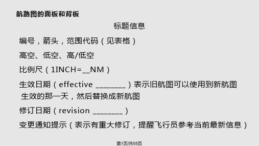
航路图的面板和背板
第八章杰普逊导航数据库与航图的差异

第八章杰普逊导航数据库与航图的差异差异差异§8.1 概述§8.2 航行资料截止日期以及生效日期§8.3 一般差异8.3.1 杰普逊导航数据库中不提供的航图资料§8.3.2 磁航迹、距离计算出的距离标绘的距离§8.3.3 数据基准/onlinepubs/wgs84.phtml页§8.4 导航设施8.4.1 完整性示位台§8.4.2 NDB和示位台的识别代码§8.4.3 示位台识别代码唯一五字码§8.4.4 重复的导航设施识别代码大量§8.5 航路点8.5.1 航路点数据库识别代码斜体字加方括号下滑角§8.5.2 单一地点的共用航路点名称§8.5.3 飞越与旁切定位点/航路点§8.6 航路航图上飞越定位点/航路点,在定位点/航路点符号外面有一个圆圈,旁切定位点/航路点则没有标示。
§8.6.1 ATS航路未包含§8.6.2 航路代号§8.6.3 高度不予显示§8.6.4 频率转换点(COP)§8.7 进场和离场程序8.7.1 不包含在数据库中的进/离场程序§8.7.2 程序标题括号六个§8.7.3 400英尺爬升程序400英尺§8.7.4 起飞最低标准和爬升梯度§8.7.5 “预期”和“条件性”指令§8.7.6 高度穿越高度最低航路高度并不包含§8.7.7 STAR的重叠航段不连续§8.8 进近程序标题和被忽略的进近程序Z忽略拒绝§8.9 进近程序的平面图8.9.1 IAF/IF/FAFA标志括号§8.9.2 基线转弯进近程序改出偏离§8.9.3 区分航空器类别的航线§8.9.4 DME和沿航迹距离(ATD)§8.9.5 至航向台的进近过渡§8.10 进近程序的剖面图8.10.1 垂直下滑角§8.10.2 数据库识别代码§8.10.3 最后进近截获定位点(FACF)。
杰普逊航图-航路图

精选课件
38
ቤተ መጻሕፍቲ ባይዱ 精选课件
39
• 单向航路
一些航路仅允许向某个方向 飞行时使用,称之为单向 航路。在航路图上,单向 航路的航路代号框用一个 箭头符号表示。
当单向航路代号框下面列出 时间时,意味着航路在列 出的时间内是单向可用的, 但在其它时间段内是双向 航路都可用的。
当前最新信息)
精选课件
3
精选课件
4
精选课件
5
航路图的面板和背板
封面索引图
·主要城市(覆盖范围内-黑色 覆盖范围外-绿色) ·政府/国家边界(浅绿色) ·时区(一系列字符T)
(时区边界线只会出现在索引图或航路图其中 之一)
·区域图覆盖范围(灰色阴影) ·使用说明(位于索引图下方,解释了空域和航路的
精选课件
40
• 有预先要求的航路
沿航路中心线的“PPR”表示 按箭头方向的飞行要求事 先得到批准。飞行员在使 用此类航路前,必须从相 应的管制部门预先获得批 准。
带有“FPR”代号的航路,则 要求按箭头方向的飞行应 预先提供飞行计划。飞行 员在使用此类航路前,必 须填报飞行计划。
精选课件
41
航路上的里程
• 沿V3航路衔接定位点的两个航 段的里程分别是30海里与22海 里,而相应的两个导航台之间 的总距离为52海里
精选课件
43
航路上的高度
·最低航路高度(MEA:
Minimum Enroute Altitude )
最低航路高度通常是在无线 电定位点之间所公布的最 低高度。该高度能保证航 路上的导航信号覆盖与接 收以及足够的超障余度( 通常规定,山区的超障余 度为2000英尺,其它地区 为1000英尺)。
最全最易懂的杰普逊航图学习课件

时区分界线用一系
他航路图都用淡蓝色的
列字符“T”表示。
主要城市轮:廓为线了表方示便。确定
政方府位/国,家很边多界大或城者市或者重
各要州的的地分方界都线包,括在在封面索
封引面图索中引。图属上于都当用前航路图
每一张航路图都包含一个使用说明。在
浅覆绿盖色范的围线内描的述城。市用黑色
这一段文字说明中,为航路图解释了空 域和航路的使用限制。特别是在一些区
杰普逊航路图正是为简化仪表领航而设计的 ,无论是在一条飞行员已经飞过上百次的航路上 飞行,还是在一条由空中交通管制部门指引的新 航路上飞行,都需要使用航路图。
航路图上包含航线、管制空域限制、导航设 施、机场、通信频率、最低航路或超障高度、航 段里程、报告点以及特殊用途空域等飞行中所必 须的航行资料。
北方向的水平定向。在
航色路虚图线上横,穿用 航连路续图的或经绿者 纬度
用航路图边缘的记号给
出磁差相等的点的连线,
叫做等磁差线,也叫做
等偏角线。
§2.2.3 航路图的边界信息
当开始检查航路图正面的符号之前,在航路 图的边界处以及航路图的边缘之外,仍可以找到一 些重要信息。例如,在每一张航路图的左上角首先 可以见到该航路图的系列号和编号。除此之外,航 路图的边界信息还可能包括航路图制图比例尺、航 图投影方式注释和航路图分节索引代码。
航路图制图比例尺
航图投影方式注释 航路图分节索引代码
§2.2.4 航路图的折页导航
在航路图的四周还有一些可以用于折页导航 的信息,当拿到所需要的航路图后,应用这些折 页导航信息可以迅速找到所需的航路资料,这些 信息包括:
锯齿形索引 航路图重叠指示标志 区域图重叠指示标志 图边“To”指示标志
《杰普逊航图航路图》PPT教学培训模板

➢它在制定公司发展战略和进行竞争对手分析中也经常被使用。 SWOT的 分析技巧类似于波士顿咨询(BCG)公司的增长/份额矩阵(The Growth/Share Matrix),
课程结束
This template is the internal standard courseware template of the enterprise
SWOT分析模板
什么是SWOT分析
➢SWOT分析是市场营销管理中经常使用的功能强大的分析工具,最早是由 美国旧金山大学的管理学教授在80年代初提出来的:S代表strength(优势), W代表weakness(弱势),O代表opportunity (机会),T代表threat(威胁)。
航路上的里程
·航段里程 小粗体数字直接标注在航线
上 ·导航设施之间的里程 小粗体数字放在六角形框内 (单位均为海里)
• 沿V1航路,衔接定位点的两个 航段的里程分别是50海里与15 海里,而相应的两个导航台之 间的总距离为65海里
• 沿V2航路衔接定位点的两个航 段的里程分别是30海里与15海 里,而相应的两个导航台之间 的总距离为45海里
SWOT分析传统矩阵示意图
内部环境
优势 Strengths
劣势 Weakness
机会 Opportunities
威胁 Threats
外部环境
SWOT行业分析适用范围
业务单元及产 品线分析
企业自身SBU SWOT分析
S
O
企W业的内外部环
境与行业平均水
T平进行比较
杰普逊航图培训一PPT教学课件

飞行部
2008年6月
2020/12/10
1
内容摘要
一、杰普逊航路手册介绍
二、航图分类与索引号
三、航路图与区域图
四、标准仪表离场图
五、标准仪表进场图
六、仪表进近图
七、机场图
2020/12/10
2
一、 杰普逊航路手册介绍
杰普逊航路手册以简单易用的专业格式为使 用者提供及时、完整、准确的飞行信息,是当前 全球航空公司和飞行员使用最广泛的一种航行资 料。
路手册的修订情况,主要包括以下三个部分: (1)修订记录——航空公司手册管理员填写。 (2)修订单——杰普逊公司每周或每两周(逢 周五)发布一次。 (3)校核单——杰普逊公司每年发布一次。
2020/12/10
4
一、 杰普逊航路手册介绍
2、简要公告(BRIEFING BULLETIN) 以简短的公告形式,告知手册本身的变化和某
2020/12/10
11
一、 杰普逊航路手册介绍
(2)航路图
根据航路图所覆盖的空域范围的不同,航路图主要 可以分为以下几种类型:
a. 低空航路图 b. 高空航路图 c. 高/低空航路图 d. 区域图
2020/12/10
12
一、 杰普逊航路手册介绍
6、无线电设备(RADIO AIDS)
此部分使用文字描述和图表形式提供了无线电 设备的信息:
7
一、 杰普逊航路手册介绍
4、航图变更通知(CHART CHANGE NOTICES)
在正常的修订周期中,如有任何资料未能及 时在航图中进行修订,杰普逊公司将发布航图变 更通知。
包括国家空域系统中相关的临时航行通告和
设施关闭、频率改变以及临时不可用的助航设备
(完整版)杰普逊航图与导航数据库

Heading Plan View
Profile View Landing Minimum
§6.2.1 Heading
The top of a Jeppesen approach chart presents basic approach information in the same order in which you would normally brief the procedure prior to flying it. The format is referred to as the Briefing Strip format.
Chapter 6 Approach Charts
Chapter 6 Approach Charts
§6.1 Introduction §6.2 Layout and Information §6.3 Non-Precision Approaches §6.4 Precision Approach §6.5 Straight-In Approaches §6.6 Approaches with Reversals
The information in chart heading includes: • Heading Border Data • Communication Row • Pre-Approach Briefing Strip & MSA
§6.2.1.1 Heading Border Data
Heading information, located on the top border of each Jeppesen approach chart, contains standard information to help you quickly identify and retrieve the approach to be briefed and flown.
杰普逊航图使用教程PPT课件

磁差 跑道号码 灯光示意图
风向标
16
跑道头标高 停机坪
正在施工或关闭区域 滑行道编号
明语注释 . 比例尺
英制跑道长度 RVR观测点 米制跑道长度
天线杆
17
第三章 航路图和区域图
.
18
【图解】 1、导航设施
甚高频全向信标
VORTAC/VORDME 无方向性 无线电信标
.
当导航设施为航路或航线 的组成部分时,其识别资 料放在带阴影的方框内, 同时标有频率、识别代号 和莫尔斯电码。用小“D” 表示DME功能。除美国和 加拿大航图外, “(T)” 代表终端,“(L)”代 表低空,“(H)”代表 高空
•仪表进近图 .
4
2、航图序号(AB-C)
第一个数字A:机场代号
第二个数字B:进近图的类型
1 - ILS,MLS
2
-
GPS(standalone)
3 - VOR
4 - TACAN
5 - 保留
.
6 - NDB 7 - DF 8 - PAR、ASR 9 - RNAV,Visual 0 - 其他航图(航路图、SID、 STAR……)
VOR 和 TAC/DME 的 天 线 不装在一起时,注明 “DME Not Co-located”
19
指点标
指点标和 NDB LOC 、 LDA or SDF 前航 道
LOC后航道
.
在高/低空航路图上, 标出构成高空或各个高 度的航路和航线的导航 设施的地理坐标(经纬 度)在区域图上,当导 航设施是航路或航线的 组成部分时,标出其地 理坐标。
终端无线电频率 和服务可以表示 在机场或地名上 方,如果无线电 呼号与机场名或 地名不同则包含 无线电呼号。
杰普逊航图与导航数据库 第三章

§3.6 Communication Frequencies
Although the types of frequencies that are shown on a chart vary, there are several standard conventions you may observe in any frequency box:
The terminal charts are divided into “0” serial charts and approach charts. “0” serial charts include area chart, departure chart, arrival chart, and airport chart, and so on.
Airport Identifier
Airport Name
Revision
Effective
Date Index Date
Location Name
Chart Identifier
Chart r
Airport Name
Airport Elevation ARP Coordinate
Chapter 3
Introduction of Terminal Charts
Chapter 3 Introduction of Terminal Charts
§3.1 Chart Identifier §3.2 Location Name §3.3 Chart Index §3.4 Chart Date §3.5 Airport Identifier and Name §3.6 Communication Frequencies §3.7 Airport Elevation §3.8 Altimeter Setting Information
- 1、下载文档前请自行甄别文档内容的完整性,平台不提供额外的编辑、内容补充、找答案等附加服务。
- 2、"仅部分预览"的文档,不可在线预览部分如存在完整性等问题,可反馈申请退款(可完整预览的文档不适用该条件!)。
- 3、如文档侵犯您的权益,请联系客服反馈,我们会尽快为您处理(人工客服工作时间:9:00-18:30)。
Formats of Airport Charts: • The “classic” chart format • The “Briefing StripTM” chart format
5
Heading of “classic” chart format
The “classic” chart format provides communication information on the right of the chart heading, with airport information on the left.
Except the length and width of stop way and taxiway, lighting system, the other part of charts are portrayed on scale.
Chart Index Number
Chart Date
14
ICAO Location Identifier and Airport
Information
The airport identifier, unique to each airport, is
a combination of the ICAO regional designation
7
§7.2 Airport Chart Information
The airport chart contains four primary sections:
• Heading • Plan view • Additional runway information • Takeoff and alternate minimums
the controlling authority
15
Communications Row
quency
Delivery Frequency
Tower Frequency
Departure Frequency
16
§7.2.2 Plan View
The airport chart plan view portrays an overhead view of the airport, it can provide you with graphical information about the airport, such as its runways and lighting systems.
and the airport’s governing agency designation
(IATA).
Airport Identifier
Airport Elevation
Coordinates represent the
ARP Coordinates airport location as provided by
§7.1 Introduction
The Airport Charts can help you find your way around the taxiways at an unfamiliar airport.
When you are airborne, you have a panel full of avionics to confirm you seem to be on your own for navigation.
Information • Communications Row
12
Location and Airport Name
Location Name/City Name
Airport Name
Select the right airport within a particular city
13
Chart Index Number and Dates
8
Heading Plan View
9
Additional Runway Information
Takeoff and Alternate Minimums
10
§7.2.1 Heading
The top of each airport chart provides standard information about airport, including the location and airport name, elevation, and communication frequencies.
4
This chart is located in one of two places in your Airway Manual:
• On the back of the first approach chart • As a standalone chart located before the
6
Heading of “Briefing StripTM” chart format
BriefinSgtriTpM
This chart format distributes the same information across the top of the chart so that you are reading it from left to right. It’s a widely used format of airport charts.
11
§7.2.1.1 Heading Border
Distinct areas of the heading: • Location and Airport Name • Chart Index Number and Dates • ICAO Location Identifier and Airport
Chapter 7 Airport Charts
1
整体概述
概述一
点击此处输入
相关文本内容
概述二
点击此处输入
相关文本内容
概述三
点击此处输入
相关文本内容
2
Chapter 7 Airport Charts
§7.1 Introduction §7.2 Airport Chart Information
3
