GPS中英文翻译--全球定位系统概述
卫星定位行业专业术语解析及翻译
卫星定位行业专业术语解析及翻译卫星定位行业常用专业术语解析1、GPS全球定位系统全名是NA VSTAR全球定位系统,它是一个星基无线电定位系统,提供给装有适当设备的用户精确的位置、速度和时间数据。
GPS直接给全世界的用户提供连续的、全天候的、免费的数据。
GPS星座由24颗卫星组成,均匀分布在6个轨道平面上,每个轨道上均匀分布4颗卫星。
系统是美国空军管理下的国防部开发的。
GSM是Global System For Mobile Communications的缩写,由欧洲电信标准组织ETSI制订的一个数字移动通信标准,GSM是全球移动通信系统(Global System for Mobile communications) 的简称。
LBS 基于位置的服务,它是通过电信移动运营商的无线电通讯网络(如GSM网、CDMA 网)或外部定位方式(如GPS)获取移动终端用户的位置信息(地理坐标,或大地坐标),在地理信息系统(外语缩写:GIS、外语全称:Geographic Information System)平台的支持下,为用户提供相应服务的一种增值业务。
2、通信协议信号源和接收器之间建立起来的一种消息传送方法,包括消息格式,消息传送的序列,还包括信号传输的必备条件,如比特率、停止位、奇偶校验和每个字符的比特数。
3、静地卫星卫星轨道沿着赤道平面,这样在地球表面上的参考点观测卫星是在一个固定的位置。
(GPS 卫星不是静地卫星)4、伪卫星地面上的转发器,用来模仿卫星,可以转发差分改正。
5、伪距计算出的GPS接收机到卫星的距离,通过确定被测卫星的传输时间和接收机测量时间之间的差值,乘以光速,就是伪距,它包括好几种误差源。
6、伪距量测量利用GPS信号上的伪随机码进行测量,提供一个到卫星的明确测量量,包括卫星和用户钟偏的影响。
7、参考卫星一种双差的实现方式,一个接收机的观测量在不同的卫星间进行差分,以消除相关误差。
通常一个卫星被选为“参考卫星”,所有其余卫星与其差分。
全球定位系统的名词解释

全球定位系统的名词解释引言:全球定位系统(Global Positioning System,简称GPS)是一种接收从空间中的卫星发送的信号以确定地球上任何一点准确位置的技术。
GPS已经成为现代社会不可或缺的一部分,广泛应用于航空航海、军事、交通导航、地理测量、旅游导航等领域。
本文将对GPS的相关名词进行解释和阐述,以帮助读者更好地理解GPS 技术的含义和应用。
一、卫星导航系统(Satellite Navigation System)卫星导航系统是指利用一组卫星来提供全球范围内的导航服务的系统。
GPS就是其中最有名的一种卫星导航系统,通过追踪和计算卫星信号的时间和位置,可以确定接收器所处的准确位置。
同时,其他国家也构建了自己的卫星导航系统,如中国的“北斗导航系统”和俄罗斯的“格洛纳斯系统”。
二、卫星(Satellite)卫星是通过人造方式被送入地球轨道并围绕地球运行的天体。
卫星在GPS系统中起到非常重要的作用,它们发送着信号,提供着位置和时间的信息。
目前,GPS系统中共有30颗左右的卫星,它们以特定的轨道运行,确保全球任何地方都能接收到有效的信号。
三、接收器(Receiver)接收器是指用于接收和处理卫星信号的设备。
在GPS系统中,接收器用于接收卫星发送的信号,解析信号中包含的时间和位置信息,并计算出接收器所处的精确位置。
接收器的发展使得GPS技术能够应用于各个领域,从普通手机上的导航功能到精密的地理测量仪器。
四、导航(Navigation)导航是指通过确定位置并计算出行的方向和距离来指引人们前往目的地的过程。
GPS通过卫星信号定位来实现导航功能,无论是陆地、海洋还是天空,只要接收器能接收到卫星信号,都可以利用GPS导航系统进行准确定位和导航。
五、精度(Accuracy)精度是指测量结果与真实值之间的接近程度。
在GPS系统中,精度表示了接收器所计算出的位置与实际位置之间的误差大小。
GPS接收器的精度受到多种因素的影响,如信号干扰、地形和大气条件等。
全球定位系统GPS

Colorado springs
地面控制部分
55
kwajalein
Hawaii
Ascencion Diego Garcia
•一个主控站:科罗拉多•斯必灵司 •三个注入站Байду номын сангаас阿松森(Ascencion)
迭哥•伽西亚(Diego Garcia) 卡瓦加兰(kwajalein) •五个监测站=1个主控站+3个注入站+夏威夷(Hawaii)
观测时间短
• 目前,20km以内相对静态定位, 仅需15-20min;快速静态相对定 位测量时,当每个流动站与基准 站相距在15km以内时,流动站观 测时间只需1-2分钟,然后可随时 定位,每站观测只需几秒钟。
测站间无须通视
• GPS测量不要求测站之间互相通视, 只需测站上空开阔即可,因此可节 省大量的造标费用。由于无需点间 通视,点位位置可根据需要,可稀 可密,使选点工作甚为灵活,也可 省去经典大地网中的传算点、过渡 点的测量工作。
Correct orbit and clock frequency
Comput e errors
Create new navigation message
upload navigation message
Monitor Station Station
Master Control Station Upload
用户部分: 接收并测卫星信号 记录处理数据 提供导航定位信息
地面控制部分:
中心控制系统 实现时间同步 跟踪卫星进行定轨
29 2024/4/4
空间部分
• 24颗卫星(21+3) • 6个轨道平面 • 55º轨道倾角 • 20200km轨道高度(地面高度) • 12小时(恒星时)轨道周期 • 5个多小时出现在地平线以上(每颗星)
gps名词解释
gps名词解释GPS是全球定位系统(Global Positioning System)的缩写,是一种通过卫星系统为用户提供精确的地理位置和导航信息的技术。
它主要由卫星系统、地面系统和用户终端三个部分组成。
卫星系统是GPS的核心部分,由一组高度约为20200公里的卫星组成,它们按照一定轨道分布在地球上空,每一颗卫星周期性地通过无线电信号向地面发送时间和位置信息。
地面系统是用来控制卫星运行和维护其正常运行的设施和设备。
地面系统监测和控制卫星运行轨迹,对卫星进行时钟校准、导航系统状态监测等,并通过地基天线与卫星进行通信。
用户终端是使用GPS系统的设备,包括GPS接收机和相关软件。
GPS接收机通过接收来自卫星的信号,计算出用户的地理位置和导航信息,然后将这些信息传输给用户。
GPS在实际应用中有多种功能。
最基本的功能就是定位,通过GPS可以精确地确定地球上的位置。
它可以提供准确的经度、纬度和海拔信息,使用户能够快速和准确地确定自己的位置。
除了定位功能,GPS还可以提供导航功能。
用户在设备上设置目的地,GPS可以提供最佳的导航路线和方向,指导用户到达目的地。
它可以通过语音提示、地图显示等方式,为用户提供导航信息,使用户能够轻松地导航到目的地。
此外,GPS还可以用于时间同步。
由于GPS卫星上有高精度的原子钟,通过接收GPS信号,可以精确地同步设备的时间。
这在许多领域都非常重要,如通信、金融、天文学等。
综上所述,GPS是一种通过卫星系统为用户提供精确的地理位置和导航信息的技术。
它通过卫星系统、地面系统和用户终端三个部分相互配合,实现定位、导航和时间同步等多种功能,具有广泛的应用价值。
GPS_百度百科
GPS_百度百科一、GPS的基本概念和原理GPS,全称为全球定位系统(Global Positioning System),是一种基于卫星导航系统的定位技术。
它由一系列的卫星、地面控制站和用户设备组成,能够准确测量地球上任意点的位置坐标,并提供导航、定位等功能。
GPS的原理主要基于三个方面:卫星发射的信号、接收器接收的信号和测量时间。
首先,GPS系统中有24颗卫星(包括备用卫星),它们通过人造卫星轨道在地球上的分布。
这些卫星以恒定速度绕地球旋转,每颗卫星每天都会固定几次跟踪站的位置,并通过无线电信号发送卫星的位置信息。
其次,GPS接收器位于地面或者其他移动设备中,用来接收卫星发射的信号。
接收器会接收到至少四颗卫星的信号,并通过测量信号的传播时间来计算接收器到每颗卫星的距离。
通过将这些距离进行三角测量,GPS接收器能够确定接收器所在的位置。
最后,GPS接收器需要测量时间来确定信号传播的速度,并精确计算出定位信息。
GPS接收器内置一个高精度的原子钟,用来测量信号传播的时间。
接收器通过比较卫星发射信号的时间和它接收到信号的时间差来计算信号的传播时间,从而得出定位信息。
二、GPS的应用领域GPS的应用广泛,涵盖了几乎所有与位置有关的领域。
下面简要介绍几个主要的GPS应用领域:1.车辆导航和交通管理:GPS可以实时导航汽车、飞机等交通工具,提供最佳路线和交通信息,并帮助交通管理部门监控交通流量和疏导交通。
2.航海和航空:GPS已经成为航海和航空领域的重要工具,可用于船舶和飞机的导航定位、航线规划等。
3.军事应用:GPS最初是作为军事导航系统而研发的,现在仍广泛应用于军事领域,用于战术导航、目标定位、军事通信等。
4.地质勘探和测绘:GPS能够提供高精度的地球表面位置坐标,因此在地质勘探、测绘和地质灾害预警等方面有重要应用。
5.环境监测和气象预测:GPS可以用于监测大气湿度、气压和大气延迟等数据,从而提供准确的气象预测和环境监测。
全球定位系统GlobalPositioningSystem,通常简称GPS

全球定位系统Global Positioning System,通常简称GPS全球定位系统(GlobalPositioningSystem,通常简称GPS)是美国国防部研制的一种全天候的,空间基准的导航系统,可满足位于全球任何地方或近地空间的军事用户连续地精确地确定三位位置和三位运动及时间的需要。
它是一个中距离圆型轨道卫星导航系统。
全球卫星定位系统(GloblePositioningSystem)是一种结合卫星及通讯发展的技术,利用导航卫星进行测时和测距。
全球卫星定位系统(简称GPS)是美国从上世纪70年代开始研制,历时20余年,耗资200亿美元,于1994年全面建成。
具有海陆空全方位实时三维导航与定位能力的新一代卫星导航与定位系统。
经过近十年我国测绘等部门的使用表明,全球卫星定位系统以全天候、高精度、自动化、高效益等特点,成功地应用于大地测量、工程测量、航空摄影、运载工具导航和管制、地壳运动测量、工程变形测量、资源勘察、地球动力学等多种学科,取得了好的经济效益和社会效益。
现有的卫星导航定位系统有美国的全球卫星定位系统(GPS)和俄罗斯的全球卫星定位系统(GlobleNaviga2tionSatelliteSystem),简称GLONASS,以及中国北斗星,欧洲伽利略。
编辑本段美国的GPS系统GPS全球卫星定位系统由三部分组成:空间部分-GPS星座;地面控制部分-地面监控系统;用户设备部分-GPS信号接收机。
1.空间部分GPS的空间部分是由24颗工作卫星组成,它位于距地表20200km的上空,均匀分布在6个轨道面上(每个轨道面4颗),轨道倾角为55°。
此外,还有4颗有源备份卫星在轨运行。
卫星的分布使得在全球任何地方、任何时间都可观测到4颗以上的卫星,并能保持良好定位解算精度的几何图象。
这就提供了在时间上连续的全球导航能力。
GPS卫星产生两组电码,一组称为C/A码(Coarse/AcquisitionCode11023MHz);一组称为P码(ProciseCode10123MHz),P码因频率较高,不易受干扰,定位精度高,因此受美国军方管制,并设有密码,一般民间无法解读,主要为美国军方服务。
《全球定位系统及其应用》 讲义

《全球定位系统及其应用》讲义全球定位系统及其应用讲义一、全球定位系统(GPS)的概述全球定位系统,英文全称为 Global Positioning System,简称 GPS。
它是一种基于卫星的导航系统,能够为全球用户提供高精度的定位、导航和时间信息。
GPS 系统由三大部分组成:空间部分、地面控制部分和用户设备部分。
空间部分由 24 颗卫星组成,这些卫星分布在 6 个轨道平面上,以确保在地球上的任何位置、任何时间都至少能接收到4 颗卫星的信号。
地面控制部分包括监测站、主控站和注入站,它们负责监测卫星的运行状态、计算卫星轨道和时钟参数,并将这些信息上传至卫星。
用户设备部分则是我们常见的 GPS 接收机,如手机、车载导航仪、手持GPS 设备等。
GPS 系统的工作原理是通过测量卫星与接收机之间的距离来确定接收机的位置。
卫星会不断发送包含其位置和时间信息的信号,接收机接收到这些信号后,通过计算信号的传播时间,就可以计算出卫星与接收机之间的距离。
然后,利用至少 4 颗卫星的距离信息,通过三角测量原理,就可以确定接收机在地球上的位置(包括经度、纬度和高度)。
二、GPS 的特点和优势1、高精度GPS 能够提供非常高的定位精度,在理想条件下,甚至可以达到厘米级的精度。
这使得它在诸如测绘、地质勘探、精准农业等领域得到广泛应用。
2、全天候无论白天黑夜、晴天雨天,GPS 系统都能正常工作,不受天气和时间的影响。
3、全球覆盖GPS 信号覆盖全球,用户在地球上的任何地方都可以使用 GPS 进行定位和导航。
4、实时性GPS 能够实时提供位置和速度信息,这对于交通运输、军事等需要实时掌握动态的领域非常重要。
5、多功能除了定位和导航,GPS 还可以用于时间同步、测量速度、监测地壳运动等多种应用。
三、GPS 在日常生活中的应用1、汽车导航这是我们最常见的应用之一。
通过车载 GPS 导航仪或手机上的导航软件,我们可以轻松规划路线、避开拥堵路段,准确到达目的地。
GPS的基本知识

• 主控站作用: 搜集各个监测站所测观察值、环境要素等数据
,计算每颗GPS卫星旳星历、时钟改正量、状态数据、以及信号 旳大气层传播改正,并按一定旳形式编制成导航电文,传送到 主控站:另外还控制和监视其他站旳工作情况并管理调度GPS卫 星。
• 注入站作用: 将主控站传来旳导航电文,分别注入到相应旳
一、空间部分(GPS卫星星座)
• 共有24颗GPS工作 卫星构成GPS卫星星 座。
• 地球上任何地方、 高度角在15以上旳 空间,可同步观察到 4~12颗卫星,卫星分 布在6个面相对于地 球赤道面倾斜角为 55旳近圆形轨道面 上,高度距地面约 2.02万km。
GPS星座示Βιβλιοθήκη 图GPS卫星基本功能 : ——接受和储存由地面监控站发来旳跟踪监测信息; ——受地面监控站旳指令,调整卫星姿态和启用备用卫星; ——进行必要旳数据处理工作; ——经过星载旳高精度原子钟提供精密旳原则时间; ——向用户广播GPS信号。
码信号到达GPS接受机旳传播时间乘以光速所得旳距离。
• 因为伪距观察量所拟定旳卫星到测站旳距离,都不可防止地会 具有大气传播延迟、卫星钟和接受机同步误差等旳影响。
• 为了与卫星和接受机之间旳真实几何距离相区别,这种具有误
差影响项旳距离观察,一般称为“伪距 ”,并把它视为GPS定位
旳基本观察量。
• 伪距法单点定位:就是利用GPS接受机在某一时刻,同步测定
三、顾客设备部分
顾客要实现利用GPS进行导航和定位旳目旳,还需要GPS接 受机,即顾客设备部分。
• 顾客设备部分作用:接受GPS卫星发射旳信号,取得必要旳
导航和定位信息及观察量,经数据处理后取得观察时刻接受机 旳位置坐标。
顾客设备部分主要由GPS接受机硬件和数据处理软件构成。
gps 导航定位英文翻译
gps 导航定位英文翻译基本解释●GPS导航定位:GPS Navigation and Positioning●音标:/dʒiːpiːɛs ˌnævɪˈɡeɪʃən ənd pəˈzɪʃənɪŋ/●名词(n) 意思:使用全球定位系统进行导航和定位的技术具体用法●名词(n):o意思:使用全球定位系统进行导航和定位的技术o同义词:satellite navigation, GPS tracking, geolocation, GPS system, GPS technologyo反义词:manual navigation, traditional navigation, non-GPS navigation, paper map navigation, compass navigation o例句:●GPS navigation and positioning have revolutionized the waywe travel, providing accurate directions and real-timeupdates for drivers and pedestrians alike.●GPS导航定位彻底改变了我们的旅行方式,为司机和行人提供了准确的方向和实时更新。
●With GPS navigation and positioning, hikers can exploreremote trails with confidence, knowing they can always find their way back.●借助GPS导航定位,徒步旅行者可以自信地探索偏远的小径,因为他们知道自己总能找到回家的路。
●The integration of GPS navigation and positioning insmartphones has made it easier for people to navigate unfamiliar cities without getting lost.●智能手机中集成的GPS导航定位功能使人们更容易在不熟悉的城市中导航而不迷路。
GPS全球定位系统详解
GPS(全球定位系统)详解全球定位系统(Global Positioning System - GPS)是美国从本世纪70年代开始研制,历时20年,耗资200亿美元,于1994年全面建成,具有在海、陆、空进行全方位实时三维导航与定位能力的新一代卫星导航与定位系统。
经近10年我国测绘等部门的使用表明,GPS 以全天候、高精度、自动化、高效益等显著特点,赢得广大测绘工作者的信赖,并成功地应用于大地测量、工程测量、航空摄影测量、运载工具导航和管制、地壳运动监测、工程变形监测、资源勘察、地球动力学等多种学科,从而给测绘领域带来一场深刻的技术革命。
全球定位系统(Global Positioning System,缩写GPS)是美国第二代卫星导航系统。
是在子午仪卫星导航系统的基础上发展起来的,它采纳了子午仪系统的成功经验。
和子午仪系统一样,全球定位系统由空间部分、地面监控部分和用户接收机三大部分组成。
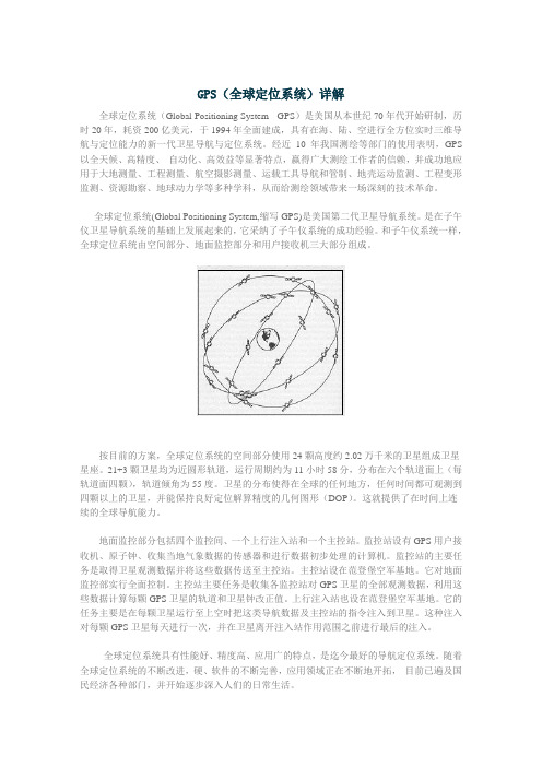
按目前的方案,全球定位系统的空间部分使用24颗高度约2.02万千米的卫星组成卫星星座。
21+3颗卫星均为近圆形轨道,运行周期约为11小时58分,分布在六个轨道面上(每轨道面四颗),轨道倾角为55度。
卫星的分布使得在全球的任何地方,任何时间都可观测到四颗以上的卫星,并能保持良好定位解算精度的几何图形(DOP)。
这就提供了在时间上连续的全球导航能力。
地面监控部分包括四个监控间、一个上行注入站和一个主控站。
监控站设有GPS用户接收机、原子钟、收集当地气象数据的传感器和进行数据初步处理的计算机。
监控站的主要任务是取得卫星观测数据并将这些数据传送至主控站。
主控站设在范登堡空军基地。
它对地面监控部实行全面控制。
主控站主要任务是收集各监控站对GPS卫星的全部观测数据,利用这些数据计算每颗GPS卫星的轨道和卫星钟改正值。
上行注入站也设在范登堡空军基地。
它的任务主要是在每颗卫星运行至上空时把这类导航数据及主控站的指令注入到卫星。
全球定位系统(中英对照)
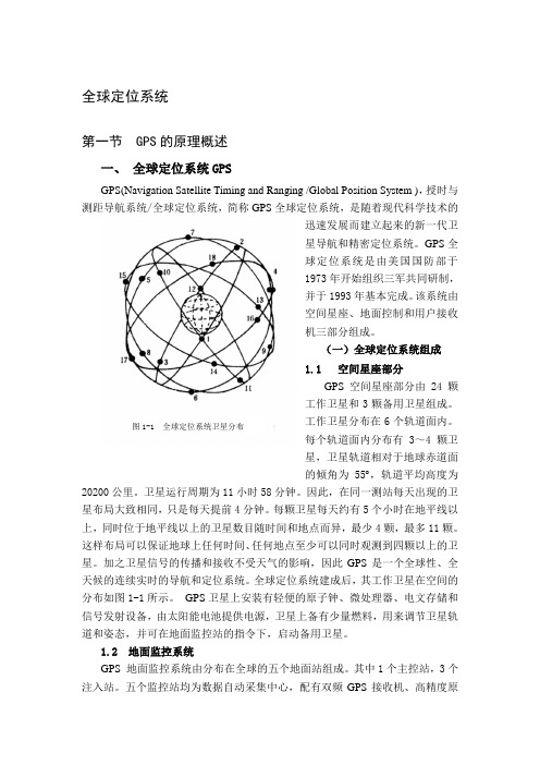
全球定位系统第一节 GPS的原理概述一、全球定位系统GPSGPS(Navigation Satellite Timing and Ranging /Global Position System ),授时与测距导航系统/全球定位系统,简称GPS全球定位系统,是随着现代科学技术的迅速发展而建立起来的新一代卫星导航和精密定位系统。
GPS全球定位系统是由美国国防部于1973年开始组织三军共同研制,并于1993年基本完成。
该系统由空间星座、地面控制和用户接收机三部分组成。
(一)全球定位系统组成1.1 空间星座部分GPS空间星座部分由24颗工作卫星和3颗备用卫星组成。
工作卫星分布在6个轨道面内。
图1-1 全球定位系统卫星分布每个轨道面内分布有3~4颗卫星,卫星轨道相对于地球赤道面的倾角为55 ,轨道平均高度为20200公里。
卫星运行周期为11小时58分钟。
因此,在同一测站每天出现的卫星布局大致相同,只是每天提前4分钟。
每颗卫星每天约有5个小时在地平线以上,同时位于地平线以上的卫星数目随时间和地点而异,最少4颗,最多11颗。
这样布局可以保证地球上任何时间、任何地点至少可以同时观测到四颗以上的卫星。
加之卫星信号的传播和接收不受天气的影响,因此GPS是一个全球性、全天候的连续实时的导航和定位系统。
全球定位系统建成后,其工作卫星在空间的分布如图1-1所示。
GPS卫星上安装有轻便的原子钟、微处理器、电文存储和信号发射设备,由太阳能电池提供电源,卫星上备有少量燃料,用来调节卫星轨道和姿态,并可在地面监控站的指令下,启动备用卫星。
1.2 地面监控系统GPS地面监控系统由分布在全球的五个地面站组成。
其中1个主控站,3个注入站。
五个监控站均为数据自动采集中心,配有双频GPS 接收机、高精度原子钟、环境数据传感器和计算设备,并为主控站提供各种观测数据。
主控站(位于美国科罗拉多)为系统管理和数据处理中心,其主要内容是利用本站和其它监控站的观测数据推算各卫星的星历、卫星钟差和大气延迟修正参数,提供全球定位系统的时间基准,并将这些参数传入注入站,调整偏离轨道的卫星至预定轨道,启用备用卫星代替失效卫星等。
GPS详解

1.什么是全球定位系统(GPS)全球定位系统(Global Positioning System - GPS)是美国从本世纪70年代开始研制,历时20年,耗资200亿美元,于1994年全面建成,具有在海、陆、空进行全方位实时三维导航与定位能力的新一代卫星导航与定位系统。
经近10年我国测绘等部门的使用表明,GPS以全天候、高精度、自动化、高效益等显著特点,赢得广大测绘工作者的信赖,并成功地应用于大地测量、工程测量、航空摄影测量、运载工具导航和管制、地壳运动监测、工程变形监测、资源勘察、地球动力学等多种学科,从而给测绘领域带来一场深刻的技术革命。
全球定位系统(Global Positioning System,缩写GPS)是美国第二代卫星导航系统。
是在子午仪卫星导航系统的基础上发展起来的,它采纳了子午仪系统的成功经验。
和子午仪系统一样,全球定位系统由空间部分、地面监控部分和用户接收机三大部分组成。
按目前的方案,全球定位系统的空间部分使用24颗高度约2.02万千米的卫星组成卫星星座。
21+3颗卫星均为近圆形轨道,运行周期约为11小时58分,分布在六个轨道面上(每轨道面四颗),轨道倾角为55度。
卫星的分布使得在全球的任何地方,任何时间都可观测到四颗以上的卫星,并能保持良好定位解算精度的几何图形(DOP)。
这就提供了在时间上连续的全球导航能力。
地面监控部分包括四个监控间、一个上行注入站和一个主控站。
监控站设有GPS用户接收机、原子钟、收集当地气象数据的传感器和进行数据初步处理的计算机。
监控站的主要任务是取得卫星观测数据并将这些数据传送至主控站。
主控站设在范登堡空军基地。
它对地面监控部实行全面控制。
主控站主要任务是收集各监控站对GPS卫星的全部观测数据,利用这些数据计算每颗GPS卫星的轨道和卫星钟改正值。
上行注入站也设在范登堡空军基地。
它的任务主要是在每颗卫星运行至上空时把这类导航数据及主控站的指令注入到卫星。
全球定位系统(GPS)详解

全球定位系统(GPS)详解全球定位系统(Global Positioning System - GPS)是美国从本世纪70年代开始研制,历时20年,耗资200亿美元,于1994年全面建成,具有在海、陆、空进行全方位实时三维导航与定位能力的新一代卫星导航与定位系统。
经近10年我国测绘等部门的使用表明,GPS以全天候、高精度、自动化、高效益等显著特点,赢得广大测绘工作者的信赖,并成功地应用于大地测量、工程测量、航空摄影测量、运载工具导航和管制、地壳运动监测、工程变形监测、资源勘察、地球动力学等多种学科,从而给测绘领域带来一场深刻的技术革命。
全球定位系统(Global Positioning System,缩写GPS)是美国第二代卫星导航系统。
是在子午仪卫星导航系统的基础上发展起来的,它采纳了子午仪系统的成功经验。
和子午仪系统一样,全球定位系统由空间部分、地面监控部分和用户接收机三大部分组成。
按目前的方案,全球定位系统的空间部分使用24颗高度约2.02万千米的卫星组成卫星星座。
21+3颗卫星均为近圆形轨道,运行周期约为11小时58分,分布在六个轨道面上(每轨道面四颗),轨道倾角为55度。
卫星的分布使得在全球的任何地方,任何时间都可观测到四颗以上的卫星,并能保持良好定位解算精度的几何图形(DOP)。
这就提供了在时间上连续的全球导航能力。
地面监控部分包括四个监控间、一个上行注入站和一个主控站。
监控站设有GPS用户接收机、原子钟、收集当地气象数据的传感器和进行数据初步处理的计算机。
监控站的主要任务是取得卫星观测数据并将这些数据传送至主控站。
主控站设在范登堡空军基地。
它对地面监控部实行全面控制。
主控站主要任务是收集各监控站对GPS卫星的全部观测数据,利用这些数据计算每颗GPS卫星的轨道和卫星钟改正值。
上行注入站也设在范登堡空军基地。
它的任务主要是在每颗卫星运行至上空时把这类导航数据及主控站的指令注入到卫星。
这种注入对每颗GPS卫星每天进行一次,并在卫星离开注入站作用范围之前进行最后的注入。
gps的名词解释
gps的名词解释GPS,全球定位系统(Global Positioning System)的缩写。
是一种基于卫星导航技术的定位系统,通过全球范围内的一组卫星,能够提供地理位置和时间信号。
GPS系统主要由卫星组成,支持接收机和控制段等多个组件。
GPS系统的工作原理是利用空间中的24颗运行着的GPS卫星,通过向地球上的接收机发送无线电信号,接收机接收到至少4颗卫星的信号后,根据信号的时间差来计算出它和卫星之间的距离,通过多边定位法原理计算出接收机的位置。
同时,GPS系统还能提供精确的时间信号,使接收机可以获得准确的时间。
GPS系统有许多实际应用,包括导航、定位、测量等各个领域。
在导航上,人们可以使用GPS定位自己的位置,并获得导航路线和方向指示;在军事领域,GPS系统被广泛应用于军事导航、轨迹追踪和火力控制等方面;在航空航天领域,GPS系统被用于航空器的导航、自动降落等;在地质勘测和土壤测量中,GPS系统也可以提供准确的测量数据等。
此外,GPS系统还在海洋、农业、气象、交通管理等领域有着广泛的应用。
GPS系统的优点在于其全球范围、高精度、即时性和可靠性。
由于卫星不受地理位置限制,因此无论在全球哪个地方,只要能接收到卫星信号,就可以进行定位和导航。
GPS系统的精度相对较高,一般能够提供米级甚至厘米级的精度。
同时,GPS系统具有实时性,即信息传输和接收几乎是瞬间完成的。
此外,GPS系统稳定可靠,可以适应各种环境和恶劣天气条件。
然而,GPS系统也存在一些不足之处。
由于信号传播的原理和限制,GPS在封闭环境、深海、深山等地形复杂的地方,接收信号可能会受到一定影响,导致定位不准确或无法定位。
此外,GPS系统也会受到人为干扰,如信号屏蔽、恶意干扰等。
此外,GPS系统也存在一定的安全性问题,如被黑客攻击、伪装等。
总的来说,GPS系统是一项重要的技术,用于提供定位、导航和时间信号。
它技术先进,广泛应用于各个领域,对于人们的出行、工作和生活有着重要的意义。
全球定位系统的介绍 外文翻译

毕业设计(论文)外文参考资料及译文译文题目:Introduction to the Global Positioning System全球定位系统的介绍学生姓名:学号:专业:集成电路设计与集成系统所在学院:电子工程学院指导教师:职称:201x年 xx月xx日Introduction to the Global Positioning System---------From “Corvallis Microtechnology, Inc.1996”Chapter One: What is GPS?The Global Positioning System (GPS) is a location system based on a constellation of about 24 satellites orbiting the earth at altitudes of approximately 11,000 miles. GPS was developed by the United States Department of Defense (DOD), for its tremendous application as a military locating utility. The DOD's investment in GPS is immense. Billions and billions of dollars have been invested in creating this technology for military uses. However, over the past several years, GPS has proven to be a useful tool in non-military mapping applications as well.GPS satellites are orbited high enough to avoid the problems associated with land based systems, yet can provide accurate positioning 24 hours a day, anywhere in the world. Uncorrected positions determined from GPS satellite signals produce accuracies in the range of 50 to 100 meters. When using a technique called differential correction, users can get positions accurate to within 5 meters or less.Today, many industries are leveraging off the DOD's massive undertaking. As GPS units are becoming smaller and less expensive, there are an expanding number of applications for GPS. In transportation applications, GPS assists pilots and drivers in pinpointing their locations and avoiding collisions. Farmers can use GPS to guide equipment and control accurate distribution of fertilizers and other chemicals. Also,GPS is used for providing accurate locations and as a navigation tool for hikers, hunters and boaters.Many would argue that GPS has found its greatest utility in the field of Geographic Information Systems (GIS). With some consideration for error, GPS can provide any point on earth with a unique address (its precise location). A GIS is basically a descriptive database of the earth (or a specific part of the earth). GPS tells you that you are at point X,Y,Z while GIS tells you that X,Y,Z is an oak tree, or a spot in astream with a pH level of 5.4. GPS tells us the "where". GIS tells us the "what". GPS/GIS is reshaping the way we locate, organize, analyze and map our resources.Chapter Two: Trilateration - How GPS Determines a LocationIn a nutshell, GPS is based on satellite ranging - calculating the distances between the receiver and the position of 3 or more satellites (4 or more if elevation is desired) and then applying some good old mathematics. Assuming the positions of the satellites are known, the location of the receiver can be calculated by determining the distance from each of the satellites to the receiver. GPS takes these 3 or more known references and measured distances and "triangulates" an additional position.As an example, assume that I have asked you to find me at a stationary position based upon a few clues which I am willing to give you. First, I tell you that I am exactly 10 miles away from your house. You would know I am somewhere on the perimeter of a sphere that has an origin as your house and a radius of 10 miles. With this information alone, you would have a difficult time to find me since there are an infinite number of locations on the perimeter of that sphere.Second, I tell you that I am also exactly 12 miles away from the ABC Grocery Store. Now you can define a second sphere with its origin at the store and a radius of 12 miles. You know that I am located somewhere in the space where the perimeters of these two spheres intersect - but there are still many possibilities to define my location.Adding additional spheres will further reduce the number of possible locations. In fact, a third origin and distance (I tell you am 8 miles away from the City Clock) narrows my position down to just 2 points. By adding one more sphere, you can pinpoint my exact location. Actually, the 4th sphere may not be necessary. One of the possibilities may not make sense, and therefore can be eliminated.For example, if you know I am above sea level, you can reject a point that has negative elevation. Mathematics and computers allow us to determine the correct point with only 3 satellites.Based on this example, you can see that you need to know the following information in order to compute your position:A) What is the precise location of three or more known points (GPS satellites)?B) What is the distance between the known points and the position of the GPS receiver?Chapter Three: How the Current Locations of GPS Satellites are Determined GPS satellites are orbiting the Earth at an altitude of 11,000 miles. The DOD can predict the paths of the satellites vs. time with great accuracy. Furthermore, the satellites can be periodically adjusted by huge land-based radar systems. Therefore, the orbits, and thus the locations of the satellites, are known in advance. Today's GPS receivers store this orbit information for all of the GPS satellites in what is known as an almanac. Think of the almanac as a "bus schedule" advising you of where each satellite will be at a particular time. Each GPS satellite continually broadcasts the almanac. Your GPS receiver will automatically collect this information and store it for future reference.The Department of Defense constantly monitors the orbit of the satellites looking for deviations from predicted values. Any deviations (caused by natural atmospheric phenomenon such as gravity), are known as ephemeris errors. When ephemeris errors are determined to exist for a satellite, the errors are sent back up to that satellite, which in turn broadcasts the errors as part of the standard message, supplying this information to the GPS receivers.By using the information from the almanac in conjuction with the ephemeris error data, the position of a GPS satellite can be very precisely determined for a given time.Chapter Four: Computing the Distance Between Your Position and the GPSSatellitesGPS determines distance between a GPS satellite and a GPS receiver by measuring the amount of time it takes a radio signal (the GPS signal) to travel from the satellite to the receiver. Radio waves travel at the speed of light, which is about 186,000 miles per second. So, if the amount of time it takes for the signal to travel from the satellite to the receiver is known, the distance from the satellite to the receiver (distance = speed x time) can be determined. If the exact time when the signal was transmitted and the exact time when it was received are known, the signal's travel time can be determined.In order to do this, the satellites and the receivers use very accurate clocks which are synchronized so that they generate the same code at exactly the same time. The code received from the satellite can be compared with the code generated by the receiver. By comparing the codes, the time difference between when the satellite generated the code and when the receiver generated the code can be determined. This interval is the travel time of the code. Multiplying this travel time, in seconds, by 186,000 miles per second gives the distance from the receiver position to the satellite in miles.Chapter Five: Four (4) Satellites to give a 3D positionIn the previous example, you saw that it took only 3 measurements to "triangulate" a 3D position. However, GPS needs a 4th satellite to provide a 3D position. Why?? Three measurements can be used to locate a point, assuming the GPS receiver and satellite clocks are precisely and continually synchronized, thereby allowing the distance calculations to be accurately determined. Unfortunately, it is impossible to synchronize these two clocks, since the clocks in GPS receivers are not as accurate as the very precise and expensive atomic clocks in the satellites. The GPS signals travel from the satellite to the receiver very fast, so if the two clocks are off by only a small fraction, the determined position data may be considerably distorted.The atomic clocks aboard the satellites maintain their time to a very high degree ofaccuracy. However, there will always be a slight variation in clock rates from satellite to satellite. Close monitoring of the clock of each satellite from the ground permits the control station to insert a message in the signal of each satellite which precisely describes the drift rate of that satellite's clock. The insertion of the drift rate effectively synchronizes all of the GPS satellite clocks.The same procedure cannot be applied to the clock in a GPS receiver. Therefore, a fourth variable (in addition to x, y and z), time, must be determined in order to calculate a precise location. Mathematically, to solve for four unknowns (x,y,z, and t), there must be four equations. In determining GPS positions, the four equations are represented by signals from four different satellites.Chapter Six: The GPS Error BudgetThe GPS system has been designed to be as nearly accurate as possible. However, there are still errors. Added together, these errors can cause a deviation of +/- 50 -100 meters from the actual GPS receiver position. There are several sources for these errors, the most significant of which are discussed below:Atmospheric ConditionsThe ionosphere and troposphere both refract the GPS signals. This causes the speed of the GPS signal in the ionosphere and troposphere to be different from the speed of the GPS signal in space. Therefore, the distance calculated from "Signal Speed x Time" will be different for the portion of the GPS signal path that passes through the ionosphere and troposphere and for the portion that passes through space.As mentioned earlier, GPS signals contain information about ephemeris (orbital position) errors, and about the rate of clock drift for the broadcasting satellite. The data concerning ephemeris errors may not exactly model the true satellite motion or the exact rate of clock drift. Distortion of the signal by measurement noise can further increase positional error. The disparity in ephemeris data can introduce 1-5 meters ofpositional error, clock drift disparity can introduce 0-1.5 meters of positional error and measurement noise can introduce 0-10 meters of positional error.Ephemeris errors should not be confused with Selective Availability (SA), which is the intentional alteration of the time and ephemeris signal by the Department of Defense.A GPS signal bouncing off a reflective surface prior to reaching the GPS receiver antenna is referred to as multipath. Because it is difficult to completely correct multipath error, even in high precision GPS units, multipath error is a serious concern to the GPS user.Chapter Seven: Measuring GPS AccuracyAs discussed above, there are several external sources which introduce errors into a GPS position. While the errors discussed above always affect accuracy, another major factor in determining positional accuracy is the alignment, or geometry, of the group of satellites (constellation) from which signals are being received. The geometry of the constellation is evaluated for several factors, all of which fall into the category of Dilution Of Precision, or DOP.DOP is an indicator of the quality of the geometry of the satellite constellation. Your computed position can vary depending on which satellites you use for the measurement. Different satellite geometries can magnify or lessen the errors in the error budget described above. A greater angle between the satellites lowers the DOP, and provides a better measurement. A higher DOP indicates poor satellite geometry, and an inferior measurement configuration.Some GPS receivers can analyze the positions of the satellites available, based upon the almanac, and choose those satellites with the best geometry in order to make the DOP as low as possible. Another important GPS receiver feature is to be able to ignore or eliminate GPS readings with DOP values that exceed user-defined limits. Other GPS receivers may have the ability to use all of the satellites in view, thus minimizing the DOP as much as possible.全球定位系统的介绍----摘自Corvallis Microtechnology公司,1996第一章:什么是GPS?全球定位系统(GPS)是一种基于24颗高度大约11000英里的地球轨道卫星的定位系统。
全球定位系统 毕业论文外文文献翻译
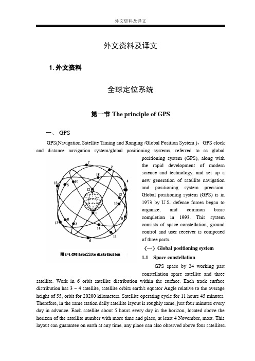
外文资料及译文1.外文资料全球定位系统第一节The principle of GPS一、GPSGPS(Navigation Satellite Timing and Ranging /Global Position System ),GPS clock and distance navigation system/global positioning systems, referred to as globalpositioning system (GPS), along withthe rapid development of modernscience and technology, and set up anew generation of satellite navigationand positioning system precision.Global positioning system (GPS) is in1973 by U.S. defense forces began toorganize, and common basiccompletion in 1993. This systemconsists of space constellation, groundcontrol and user receiver is composedof three parts.(一)Global positioning system 图1-1 GPS Satellite distribution1.1 Space constellationGPS space by 24 working partconstellation spare satellite and three satellite. Work in 6 orbit satellite distribution within the surface. Each track surface distribution has 3 ~ 4 satellite, satellite orbits earth's equator Angle relative to the average height of 55, orbit for 20200 kilometers. Satellite operating cycle for 11 hours 45 minutes. Therefore, in the same station daily satellite layout is roughly same, just four minutes every day in advance. Each satellite about 5 hours every day in the horizon, located above the horizon of the satellite number with more time and place, at least 4 November, most. This layout can guarantee on earth at any time, any place can also observed above four satellites.Satellite signal transmission and reception and the influence, so the GPS is a global, all-weather real-time navigation and positioning for system. After the completion of the global positioning system, its work in the space distribution of satellite 1-1 as shown. GPS satellite zips are installed on the light, microprocessors, message signal emission equipment, storage, and provide power supply by solar cells have little fuel, satellite is used to regulate the satellite orbit and posture, and in the monitor of instruction, start spare satellite.1.2 The ground monitoring systemGPS ground monitoring system in the world by five sites. One master station, 3 injection station. Five monitor are equipped with automatic acquisition, data center, double-frequency GPS receiver, precision clock, environmental data sensors and computing devices, and to master station provides all kinds of observation data. Master station (in Colorado) for system management and data processing center, its main content is the use of this site and other monitor the observation data of the satellite's star calendar calculation and satellite clock and atmospheric delay correction parameter, provide global positioning system, and the time base station, these parameters to adjust sidetracked into orbit, the satellite to enable spare satellite instead of failure satellite, etc. Injection station master station will be calculated and satellite star calendar, clock, satellite navigation message and other control commands into corresponding satellite etc, and storage system into the correctness of monitoring information. Besides, the master station, GPS ground monitoring system, various unattended highly automated and standardized work.1.3 User equipment partsUser equipment including GPS receiver host, antenna, power and data processing software component. The host for the microcomputer, quartz oscillators core, and the corresponding input and output interface, and equipment. In the special software under control, the host for homework, satellite data acquisition, processing and storage of the equipment, the system state inspection, alarm and maintenance, the receiving system of automatic management. Antenna, often used for collecting all from each azimuth, arbitrary nonnegative Angle of satellite signal. Due to the satellite antenna pedestal weak signal in a pre-amplifier, amplification, reoccupy coaxial cable input host. Power supply for host and aerial part, can use through rectifier voltage, the mains, also can use the accumulator.(二)Global positioning system (GPS) signalsGPS satellite launch a coherent wave, the wavelength 1L and frequency respectively 2L :f MHZ,cm f MHZ,cm L L L L 11221575421912276024====..λλ1L and 2L as a carrier with two modulation signal, a kind of navigation signal, another kind is message signal. Navigation signal S Mb 023.1 is divided again, frequency m A C 293=λ for code rate for the coarse yards (C/A code) and the rate SMb 023.1for the essence, the frequency of m p 3.291=λcode (P). Thick yards (C/A code) repeat each signal encoding, can quickly capture signal, according to the design for rough positioning, Pure code (P) yards signal encoding every seven, and repeat each satellite, structure is very complex, not capture, but can be used for accurate positioning. Message signal while the rate s bit 50to the carrier 1L and 2L modulation in, including satellite, the correct star calendar and satellite working state. Through the message signal receiver can choose the best one group of graphics, positioning signals observation data processing..第二节 GPS Positioning method一、 GPS Positioning method classification(一)、 The static and dynamic positioningBy means of static GPS positioning and can be divided into dynamic positioning.1、Static positioningIf you stay in the surrounding relatively fixed protection can not perceive motion, or movement is so slowly that require months or years, namely that can be reflected in the earth for fixed-point relative coordinates is fixed, the determination method for the coordinates of static positioning is called. In the mathematics model of the static localization, the position is constant. Due to the rapid solutions of GPS "unknown" technology of the cycle time of operation, static already shortened to a few minutes, so, in addition to the original geodetic measurement and monitoring of the force applied, rapid static orientation has been widely applied to the common measurement and engineering measurement.2、 Dynamic positioningCars, ships, aircraft and aircraft in motion, people often need to know their real-time position. In these sports carrier mounted on GPS receiver, real-time GPS signals measured antenna location, called the GPS kinematic positioning. If the only measure the real-time position, the carrier of sports also determine the speed, time and location, etc, thus guidingstatus parameters to reserve the object orientation, called the navigation movement. GPS navigation is virtually dynamic positioning.(二)、Absolute positioning and relative locationAccording to determine the GPS receiver in earth coordinate system in different position, can be divided into a single absolute positioning and the relative positioning, such as machine, 2-1.1、Absolute positioning图2-1 Absolute and relative positioningTo determine the absolute positioning is independent coordinate system in the position of the dot. Because single absolute positioning error by satellite reception when the effect, low precision. Mainly used for low precision dynamic positioning, such as ships, aircraft navigation of mineral resources, geological investigation, Marine fishing and determine the relative position of the initial value.2、Relative positioningRelative location is determined simultaneous tracking same GPS signals of several sets of the relative position between the receiver is a kind of method. Since the synchronous observation, the synchronization of many error signal obtained station is identical or similar (such as satellite clock error, error, the signal of the star alex atmospheric transmission error, etc.), can avoid or weaken these errors, obtain high relative position. Relative positioning, signal processing and data than absolute orientation is complex, relative positioning is the synchronization between baseline vector (station), and 3d coordinate need at least a spot for known to the rest of the each point coordinates. The static and dynamic positioning can position by relative positioning, such as earthdeformation measurement, ground control aerial photogrammetry, etc.In the dynamic positioning, often USES "difference", a GPS receiver will be placed on the base coordinate, known as the receiver in sports, all receivers carrier, according to the known synchronous control results, the positioning correct number starting position, in order to improve the real-time to positioning accuracy. This is based on a single point positioning and relative location of positioning mode.(三)、 Pseudorange method and the carrier phase methodGPS satellite positioning, according to the different signal processing, can divide again pseudorange method and the carrier phase method.1、Pseudorange methodThe positioning principle is simple. When positioning, receiver and the oscillation ofA satellite signal the same group (P yards range yards or C/A code), through delay and receiver receive signals, when two groups compared each other completely coincide (related to signal measured signals, namely for the delay in quantity, satellite signal transmission time with A series of modified times the speed of light, satellites and draw the oblique distance antenna phase center. If the four (or above), i.e. the distance can satellite stations calculate intersection method of location and clock error four unknown. Due to the wavelength m p 3.29λrange yards m A C 293=λ. To one percent of the estimated $yards range resolution, length of to 0.3 meters (P) and 3 meters (C/A code) the ranging accuracy. Therefore, the pseudorange accuracy is relatively low.2、The carrier phase methodThe carrier is a measure of carrier signal, measurements, determine the satellite signal and reference signal receiver, calculate the phase difference observation. Then the same principle and pseudorange method, the position of the station clock error, etc. The wavelength modulated symbol cm L 191=λ,cm L 242=λ, than much shorter wavelength of one percent, to $yards range resolution, estimating length reached 1.9 cm (P) and 2.4 L centimeters (C/A code) the ranging accuracy. In the measurement and precision air triangle measuring, high precision, often USES relative positioning method, the carrier phase to eliminate system error.The carrier phase method for measuring the complete phase observation data ϕfrom several parts:ϕϕϕϕφφ=-=+=++S R R N N I n tF 00~()() (2-1)Type: s ϕfor the first phase, the observational S,R ϕ for the position of the receiverobservation R phase, ~ϕfor the actual phase observations,0N for the whole cycle count,also called the whole cycle unknown, ()φInt for the actual observation time t the integer part, first observed 0t for the duration of zero, every moment, observation 0t by continuous accumulated through counter counts, called after the cycle count, ()φR F for the actual observation in the integer part, with high precision measurement.二、GPS positioning operation modeMainly includes GPS real-time GPS navigation positioning, afterwards (with) the dynamic positioning and used to measure the static or dynamic) relative orientation accurate.1 . GPS kinematic positioningGPS real-time navigation) is required (and observation data in the positioning of the moment, its main purpose is to navigation. AS mentioned above, the absolute positioning (single point positioning) by the us government's "SA" (choose usability) and "AS" (the electronic technology, the influence of deception by civil service standard of GPS level position precision of 100 meters. So many users using differential GPS system (CDGPS and WADGPS) to improve the precision. CDGPS pseudorange method and the users of the station standing range within 100 miles, precision for 5 ~ 10 meters. The carrier phase method CDGPS (also called RTK) standing and users in the station within range, 30 kilometers, the accuracy of cm. And WADGPS big scope is to create multiple known coordinates, standing and vice standing vice standing by data from receiving chain of error sources, after three corrections to users, communication WADGPS pseudorange method for positioning accuracy of about 1 ~ 3 meters, CDGPS superior. And stood and vice standing distance can reach over 1000 kilometers.2. Dynamic positioning postprocessingThis is a kind of carrier phase of dynamic positioning technologies. Usually a receiver is placed in the ground, and the other on the known a (or more) receiver in high-speed motion object, jr, afterwards synchronous according to the carrier phase difference between objects in motion relative to determine the location of known. Its characteristic is standing with users need to stand between the transmission of real-time data, the distance between the two is less restricted. But in high-speed motion of the object is how to determine the unknown 0N and the whole week jump problem is the technical difficulties. In recent years, the GPS technology of dynamic initialization OTF (again) greatly improve something comes after the practicability of the dynamic positioning. It can reach thecm-level positioning accuracy. Mainly applicable and low orbit satellite cm-level precision GPS satellite, aerial photogrammetry, airborne gravimetry, magnetic moment of determine the cm-level 3d coordinate of the airborne GPS technology.ed to measure the static(and dynamic) relative positioningStatic relative positioning using two sets of (or above), the GPS receiver respectively in each of the baseline endpoints, synchronous observation above four satellites 0.5 ~ 1 hour, baseline length in 20 kilometers. The baseline netted closed graph, constitute the whole event after adjustment, the precision can reach D5. Applicable to higher+1mm⋅ppmaccuracy of measurement and control of national land earth deformation monitoring, etc.Rapid static relative position in the central area with a base station, GPS receiver continuous tracking all visible satellites, in order to each other a receiver to the above five starting synchronous satellites, each 1 ~ 2 minutes to benchmark station starting at baseline length within 15 kilometers, with the benchmark stood for radiation center. Afterwards the processing precision can reach D+15, but poor reliability. Applicable to smallmm⋅ppmrange of control measure, engineering surveying and cadastration, etc.Accurate dynamic relative position in the zone, a GPS receiver with benchmark for tracking all visible satellites, another a receiver in starting sites for five first above synchronous satellites for 1-2 minutes and then keep track of all of the satellite, under the situation of continuous flow to the observation of the number of seconds, the observatory was starting to stand at the baseline length benchmark within 15 kilometers. Its characteristic is starting to keep each phase lock. In case of loss locks, must extend unlocked site observation time after 1 ~ 2 minutes to determine the unknownN and the0 whole cycle count cycle()φInt. Accurate dynamic relative positioning error in baseline can reach 1 ~ 2 cm long, suitable for engineering measurement circuit measurements and topography measurement, etc.第三节GPS application一、The GPS in engineering applicationIn surveying and mapping, GPS satellite positioning technology field has been used to establish the national geodetic measurement accuracy control network, determination ofthe earth; the dynamic parameters of the global To establish the land and sea, high-precision measurement datum of land and sea islands; measurement of surveying and mapping al Used for monitoring earth plate motion and the crustal deformation, Used for engineering measure, establish a city and the major means of engineering control network, Used for testing the aerospace photography instant camera position, only a very small ground control or no ground control chart, causing rapid aerial geographic information system, the global environment of remote sensing technology revolution.In the survey, using GPS technology to develop international league, establish the control of global network, provide high-precision geocentric coordinate, determination and refining geoid. So, for every Chinese department of surveying and mapping work, establish various measurement control network, provides the high plane and elevation 3d benchmarks.In the engineering survey, the application of static GPS positioning technology, relatively precise control network layont for mining cities, and the subsidence monitoring, oil dam deformation monitoring, high-rise buildings deformation monitoring, tunnel breakthrough measurement precision engineering etc. Encryption, using GPS surveying asbuilts of real-time dynamic positioning technologies (hereinafter referred to as RTK surveying and mapping) of scale topographic map and used in the construction of engineering construction lofting.In aerial photogrammetry, using GPS surveying workers also aerial technology field control measure, aerial electricity GPS navigation, airborne flying into the figure of the electricity, etc.On earth, GPS technology used in dynamic monitoring global and regional plate, plate motion of movement monitoring.The global positioning system (GPS) technology has been used in Marine measurement, underground terrain mapping and, moreover, the military defense, intelligent transportation, post and telecommunications, surveying, coal, oil, building and management of agricultural, meteorology, land, environmental monitoring, finance, public security departments and industry, in aerospace, test, physical detection, etc, also pose measurement are conducted the research and application of GPS technology.二、The GPS in scientific research applicationsThe global positioning system (GPS) used in mobile positioning and economical solutions when we directly transferred to customer service center, the mobile phone to check with customer directly short message (GPS positioning, minutes and seconds data format), if the use of electronic map software, general inter-city direct support of its inputGPS data, minutes and seconds, if use the function orientation LingTu days in Beijing, can use the new 5 special software of GPS positioning master manual input coordinates function orientation, this scheme is suitable for low frequency ZhaChe. Enhanced when customers can purchase special satellite positioning management host, it can not only be receiving many car positioning short message, and stored in computer automatic classification, each vehicle is to build a database of clicking a mouse button, finding a car, as long as all the locating records on target data will automatically switch to electronic map shows the location, click on the progress vehicle or the back button on electronic map can demonstrate in the form of automobile, each vehicle can take different names, facilitate management more cars, very convenient, more frequent query for car. Along with the rapid development of urbanization, urban scale expands unceasingly, to provide convenient and fast traffic intelligent transportation information service system, will be the future trend of development, In addition, navigation and positioning system based on mobile phone service, will become the trend for the people to pursue. In the future, all can move, will depend on the GPS. GPS will like mobile phones, Internet, for our life greatly influence. Therefore, the GPS will form the huge industry value chain, significant social and economic benefits.三、In the emerging field of application of GPSRTK technology is RTK network a milestone in the development of technology. This technique by several stations composed a network, and has a terminal. Each station by telecommunications network (fiber or DDN) will observation data, the central station to station by reference data and the model through a solution within the pressure-difference method is correct and its through GSM/GPRS public Internet user, users send according to the real-time difference correct information can obtain higher precision. Compared with the traditional RTK technology, network RTK distance between the base can be long, sichuan VRS seismological bureau standing space than average system construction of 60 kilometers, is the longest baseline once more than 90 kilometers. So, same area covered only need less station can be achieved, cost can be greatly reduced. At the same time, the concept of network calculation model makes more reliable. Traditional RTK system if a base, the user can occur in the base area in the implementation of homework, covering technology in network RTK nonexistent this problem, because the center will automatically according to the user's position and the operation condition of choosing base stations operations. With modern communication technology, the computer storage technology and the rapid development of space technology, measuring method and mode has achieved great progress. GPS network in the information revolution is RTK arises inthe new space data acquisition method. It combines modern technology of communication and information technology, computer network distributed storage and processing technology of virtual reference, standing technology (VRS) among, and modern geodetic technology. GPS network is more advanced technology of RTK integration, this system for the country's infrastructure provide conveniences. Also for "digital city provides real-time reliable source.2.译文全球定位系统第一节 GPS的原理概述一、全球定位系统GPSGPS(Navigation Satellite Timing and Ranging /Global Position System ),授时与测距导航系统/全球定位系统,简称GPS全球定位系统,是随着现代科学技术的迅速发展而建立起来的新一代卫星导航和精密定位系统。
- 1、下载文档前请自行甄别文档内容的完整性,平台不提供额外的编辑、内容补充、找答案等附加服务。
- 2、"仅部分预览"的文档,不可在线预览部分如存在完整性等问题,可反馈申请退款(可完整预览的文档不适用该条件!)。
- 3、如文档侵犯您的权益,请联系客服反馈,我们会尽快为您处理(人工客服工作时间:9:00-18:30)。
本科毕业设计(论文)中英文对照翻译院(系部)专业名称年级班级学生姓名指导老师2010年06月11日Summarizing The Global Positioning System Abstract:Global Positioning System is based on the background of the United StatesDepartment of Defense.It is designed,invested,developed,and operated by the United States Department of Defense ,GPS is a satellite-based positioning and time transfering GPS positioning function has a wide range of applications in the modern measurement and a more modern building.GPS-RTK technology is also widely used in modernization building, and now GPS has also been shown to be an important civilian communities of interest, and increasingly wide range of applicated.Keyword:GPS,Locating,RTK,Lay out,Survey1.BackgroundThe 50s, the former U.S.S.R has not launched humanities first artificial earthsatellite, the American scientists in along its track research in, had discovered theDoppler shift phenomenon, and has facilitated Doppler satellite navigation posi- tioningsystem completing using this principle, has obtained the enormous success in themilitary and the civi aspect, was in a navigation localization history leap, our countryonce has also introduced many Doppler receiver, applied to the island associationmeasured, the Earth explored and so on the applied to the island association measured,the Earth explored and so on the domain. But because Doppler satellite orbit highly low,signal-carrier frequency low, the track precision enhances with difficulty, causes thepointing accuracy lowly, satisfies the geodetic survey or the project survey request, ismore impossible to use in the astronomy Earth dynamics research. In order to enhancethe satellite positioning the precision,US started from 1973 to prepare for constructionglobal positioning system GPS (Global Positioning System).After has entered the planproof, the system test stage,started in 1989 to launch the official work satellite,andcompletely completed in 1994, investment use. The GPS system spaceartially iscomposed by twenty one satellites, evenly distributes in six orbit, the ground level is20,000 Kilometers, the inclination of orbit is 55, the flat heart rate approximately is 0,the week contract is 12 hours, the satellite to the earth launching two wave bandsintelligence signals,the intelligence signal frequency respectively is 1575.442 megacycles per second (the L2 wave band), on the satellite has installed the precision veryhigh atomic clock, guarantees the frequency the stability, modulates in the carrier has the expression satellite position the broadcast star experience, use in the range finder C/A code and P yard, as well ad other system information, can in the global scope, to willfully multi-user provide the high accuracy, all-weather, is continual, real-time three dimensional measures fast, the three dimensional localization and the time service.The GPS system control section by is located in the American foundations of the states 5 monitoring stations to be composed, these stand did not ask breaks Carries on the observation to GPS satellite, and will calculate and the forecast information by the infusion stands renews to the satellite information.The GPS system user is extremely covert, it is one kind of one-way system,the user only receives but does not need the transmitting message, and therefore user' s quantity also is not limited. Although GPS is the unification starts is, but very quantity also is not limited. Although GPS recei ver and processing software emerge in abundance. At present the receiver which appears in the Chinese market mainly has ROGUE,ASHTECH, TRIMBLE, LEICA, SOKKIA, TOPCON and so on.. Can carry on the observation to two frequencies the receiver to be called the double frequency receiver, only can carryon the observation to a frequency the receiver to become the inference. Says regarding the mapping user, GPS has caused the revolutionary change in the mapping domain, at present, in the scope several thousand kilometers controls network, in the precision from hundred to the millimeter level localization, generally all GPS took the first choice method, is day by day mature along wi th the RTK technology, GPS started to decimeter and even a centimeter level layout, domain seepage and so on high accuracy dynamic localization.The international GPS geodetic survey served IGS with Earth dynamics from 1992, has established many data storage and the processing center in the whole world, year to year observed a station with hundred, our country has also set up Shanghai Y u Shan, Wuhan, Xian, Taiwan and so on many year to year measuring platforms station, these stations observation data passed on every day through the internet net to US' S data storage center, IGS also nearly real-time synthesizes various data processing center the result, and the participant international earth rotation served the IERS global coordinates reference system maintenance and the earth rotation parameter issue. The user also mayfree on-line obtain product and so on observation data and precise star experience from internet.The GPS system real-time navigation pointing is very high,US hasimplemented the so-called SA policy in 1992, namely reduces the broadcaststar to undergo the star posi tion precision, reduces the star clock to change thepositive number the precision, adds on the high frequency vibration to thesatellite datum frequency (to cause false distance measuring accuracy to reducewith phase ), latter has implemented the A-S policy, soon P yard change is Y yardnamely further limi ts to the precise false distance survey, but American military and special permission user not these polices influences, but US in order to obtain the bigger commercial interest, these policy ends are cancelled.2.GPS localization principalThe GPS receiver may receive and use in the time service accurately to the nanosecond level time information; will use in to forecast the future for several months the satellite to locate the summary position forecast star experience; Uses in calculates when the localization to need the satelli te coordinates the broadcast star experience, the precision is (each satellite is different several meter to several dozens meters~changes as necessary); As well as GPS system information, like satellite condition and so on.The GPS receiver may obtain the satellite sign to the code to the receiver distance, because includes the receiver satellite clock the error and the atmosphere propagated error, therefore is called the false distance. The false distance obtains which to the OA code is called the UA code false distance, the precision approximately is about 20 meters, obtains the false distance to P yard to be called P yard false distance, the precision approximately is about 2 meters.The GPS receiver to the satellite signal which receives, carries on the decoding or uses other technologies, will modulate after the carrier the information removes, will be allowed to restore the carrier. Strict says, the carrier phase should be called the carrier beat frequency phase, it is receives produces the Doppler shift influence satellite signal carrier phase and receiver this machine vibration difference of the signal phase. Generally experience Yuan time which determined in the receiver clock surveyed, maintains to the satellite signal track under, may record the phase change value, butstarts time the observation receiver and the satellite oscillator phase change value is does not know, namely misty degree of whole week, only can calculate in the data processing as the parameter solution. Phase observation value precision high to millimeter, but the premise is solves misty degree of whole week, therefore only has when the relative localization, and has a section continuously observes the value can use the phase observation value, but must achieve meters down to themillimeter level also only to be able to use the phase observation value.According to the locate mode, the GPS localization divides into the simple point localization and the relative localization (difference localization). The simple point localization is according to a receiver observation data determined the receiver position the way, it only can use the false distance view survey, may use in Chef Chuan and so on the summary navigation localization. The relative localization (difference localization) is according to two above receivers observation data determined between the observation point the relative position method, it already may use the false distance view survey also to be possible to use the phase view survey, the geodetic surveyor the project survey should use the phase observation value to carryon the relative localization. Has contained the satellite and receiver ZhongChai, the atmospheric dissemination in the GPS view survey retards, error and so on multipart effect, when localization error the influence, when carries on the relative localization the majority of public errors are counterbalanced or weaken, therefore the pointing accuracy greatly will enhance, the double frequency receiver will be allowed to act according to two frequencies in the view survey counterbalance atmosphere the ionosphere-path error main part, will request high in the precision, between the receiver the distance wi11 be farther when (atmosphere will have obvious difference), will be supposed to select the double frequency receiver.When localization observation, if the receiver is opposite to the earths surface movement, then is called the dynamic localization, like uses in summary navigation localization the and so on Chef Chuan precision is 30-100 meter false distance simple point localization, either uses in the city vehicles navigation localization rice level precision false distance difference localization(RTK), the real-time difference localization needs the data chain real-time transmits two or many stations observationdata calculates together.When localization observation, if the receiver is opposite to the earths surface static, then is called the static localization, when carries on controls the net observes, generally selects this method by several receivers also to observe, it can maximum limit display GPS the pointing accuracy,special-purpose Yu Zheizhong the goal receiver is called the earth receiver,is in the receiver a performance best kind. At present, GPS already could achieve the earths crust performance observation the precision request, IGS year to year the measuring platform already can constitute millimeter level the global coordinates frame.3.RTK technologiesThe conventional GPS measuring technique, like the static state, the fast static state , the dynamic survey all~eed afterwards to carryon the solution to calculate can obtain a centimeter level the precision, but RTK is can real-time obtain the centimeter level pointing accuracy in the open country the measuring technique, it has used the carrier phase dynamic real-time difference (Real-timekinematics) the method, is the GPS application significant milestone, its appearance for the project layout, the terrain mapping, each kind of control survey has brought the new dawn, enormously enhanced the field operation work efficiency.The high accuracy GPS survey must use the carrier phase observation value,the RTK localization technology, it can real-time provide in assigns in the coordinate system the three dimensional localization result, and achieves the centimeter level precision. Under the RTK work pattern, the datum stands through the data chain transmi ts together its observation value and the survey station coordinates information for the mobile station. Mobile stands not only receives the data through the data link which stands from the datum, but also must gather the GPS observation data, and composes the difference observation value in the system to carryon the real-time processing, simultaneously produces the centimeter level localization result, a lasted. The mobile station may be at the static condition, also may be at the state of motion; May first carryon the initialization after the fixed point to enter the dynamic work again, also may under the dynamic condition directly opening machine,and completes theweek fuzziness search solution under the dynamic environment. After end knows the number solution to be fixed, then carries on each calendar Yuan real-time processing, so long as can maintain four above satellites phases observation value the track and the essential geometric figure ,then the mobile station may produce the centimeter level localization result as necessary.The RTK technology key lies in the data processing technology and the data transmission technology, when the RTK localization requests the datum station receiver real-time the observation data (false distance observation value, phase observation value) and the know data transmission for the mobile station receive, the data quantity quite big, generally all requests 9,600 bauds rate, this in on radio is not difficult to realize.4.The application of RTK(1)Each kind of control surveyThe traditional geodetic survey, the project control survey uses the triangular net, the line-network method executes measured, not only requires a lot of work time-consuming, request Indivisibility, moreover the precision distribution non-uniformity, also at the field operation did not know how the precision, does use conventional the GPS static state survey, the fast static state, the false dynamic method, survey in the process at field operation not to be able real-time to know the pointing accuracy, after if surveys completes, after returns to house processing to discover the precision does no t gather the request, but also must return measured, but uses RTK to carryon the control survey, can real-time know the pointing accuracy, if the fruits and cakes position precision request has satisfied, the user was allowed to stop observing, how moreover knew the observation quality, This may greatly enhance the work efficiency. If uses in the road control survey RTK,electronic circuit control survey, the hydraulic engineering control survey, the geodetic survey, then not only may greatly reducethe manpower intensi ty, the economical expense, moreover greatly enhances the working efficiency,measured a control point may complete in several minutes even several seconds.(2)Terrain mappingIn the past measured when topographic diagram generally first must in measure area establishment chart root control point, then on chart root control point top carriage entire station meter or altazimuth coordination small flat panel mapping, now develops the field operation with the entire station meter and the electronic hand coordination thing code, uses big scale mapping software to carryon the mapping, even develops recent field operation electron dull mapping and so on, all requests in the survey station to measure all around terrain landform and so on department point, these points all wi th survey station indivisibility, moreover generally requests at least 2-3 person to operate, needs when puts together the chart once the precision not to gather the request also to obtain the field operation to return measured,when now uses RTK, only needs a person to carry the instrument in on the terrain landform department point dull 12 second kinds which must measure, and simultaneously inputs the characteristic code, through hand book may real-time know the position precision, after measured a region returns to in the room, may output the topographic diagram by the specialized software connection which requests, like this uses RTK only to need a person to operate,does not request a between indi visibi Ii ty, greatly enhanced the working efficiency, uses the RTK coordination electron hand book to be allowed to survey each kind of topographic diagram, I ike the ordinary mapping, the track,line strip the shape topographic diagram surveying, road pipeline topographic diagram surveying, coordinates the depth-finding device to be allowed to use in to measure the reservoir topographic diagram, Navigation sea mapping and so on.(3)LayoutLayout surveys an application branch, it request through the certain method to use the certain instrument the spot position which artificial designs in really for to demarcate, in the past used the convention layout the method very many, like the altazimuth junction met layout, when the ent ire 50 station meter and so on, generally layout a design position, often needed the back and forth bile target, moreover took 2-3 person to operate, simultaneously also requested the indivisibility situation in the process to be good, in the production application the efficiency was not very high, sometimes layout encountered the difficult situation to be able to draw support fromYu Hindu the methodto layout. Sometimes, if uses the RTK technology layout, only must the spot position coordinates which designs input to the electron hand, is carrying the GPS receiver, it can remind you to walk to want to layout a position, both rapid and convenient, because GPS is comes directly through the coordinates layout,the precision is very high, thus can greatly enhance efficiency, also only needs a person to operate.5. The application of GPSGPS offers for military and makes a reservation and sets up accurately at first, it is still controlled by the American military so far. Military GPS products is it confirm and follow in field advancing soldering and coordinating of equipment in to used for mainly, the gunship for the sea navigates, offers the position and navigation information for military aircraft.(1) The GPS system use is extensivelyAt present, application, GPS of system very extensive already, we can use GPS signal can carryon sea, empty and navigation of land, the guidance of the guided missile, earth measurement and accurate localization of project measurement., transmission of time and measurement of the speed,etc.For survey and draw field,GPS satellite fix technology is it set up nationwide earth measurement of high accuracy control network to use for already, determine global dynamic parameter of earth;Used for setting up land marine earth measurement datum, unite and examines and surveys and draws in the ocean the high-accuracy island land;Used for moni toring plate motion state of the earth and the earths crust deformation;Used in project measure,is it set up city and project control main means of network to become For determine Aero-Space photograph camera position in the twinkling of an eye, realize for a small amount of ground control or there is no aerial survey controlled in region to become and pursue fast, technical revolution causing the geographical information system,global environmental remote to follow their monitor.A lot of commerce and government organs use GPS equipment to follow their vehicle position;This generally needs to draw support fromwireless communication technology.Some GPS receiver integrated radio, radio telephone move data terminal is it meets need, motorcade of management to come.(2) Appearance of the resource environment of pluralistic spaceAt present, GPS, GLONASS, INMARSAT waits for the system to all possess and navigate to orient the function, formed the pluralistic room resource environment. This pluralistic space environment ,has impelled and fumed a piece of common tactics internationally and folly, namely on one hand fully utilize the existing system, on the other hand prepare to establish folk GNSS system actively ,by the tome around the2010,GNSS folk system build our purely, the woke world form the tendency that GPS/GLONASS/GNSS stood like the legs of a tripod, could get rid of the reliance on the single system fundamentally, form owning in common, security resource environment which world shares of worlk.World can is it is it use realm at most as single navigation means to navigate satelli te to enter. This international and folk strategy, there id influence and force U.S.A to use the policy to make more omen adjustment to its GPS converselu. Inaword , because of the establishment of the resource environment of pluralistic space ,have created an unprecedented gapped international environment for the development and application of GPS.(3) Develop gaps industryGPS Will form industrialization like the automobile, wireless communication at present in the future, US>A strengthen wide area systematic WAAS (namely wide area is it revise date chain transfer to already, it make geostationary satellite it have C? A yards of function too, form wide area the GPS strengthen system of) plan international standard of developing into of. Some units produce car-mounted GPS system too at present in our country.For GPS industry of developing our country, already China GPS project centrehas been established in Wuhan.全球定位系统概述摘要:全球定位系统是以美国国防为背景,由美国国防部设计、投资、开发、和运行的。