专业英语翻译道桥方向
专业英语[土木工程专业(路桥方向)]
![专业英语[土木工程专业(路桥方向)]](https://img.taocdn.com/s3/m/e605d190bceb19e8b8f6baef.png)
Lesson 1 Careers in Civil EngineeringMany civil engineers, among them the top people in the field work in design. As we have seen ,civil engineers work on many diferent kinds of structures , so it is normal practice for an engineer to specialize in just one kind . In designing buildings ,engineers often work as consultants to architectural or construction firm.Dams, bridges, water supply systems and other large project ordinarily employ several engineers whose work is coordinated by a system enginneer who is in charge of the entire project . In many cases engineers from other disciplines are involved .In dam project , for example , electrical and mechanical engineers work on the design of the powerhouse and its equipment. In other cases , civil engineers are assigned to work on a project in another field ; in the space program , for instance ,civil engineers were necessary in the design and construction of such structures as launching pads and rocket storage facilities .Construction is a complicated process on almost all engineering projects. It involves scheduling the work and utilizing the equipment and the materials so that costs are kept as low as possible . Safty factors must also be taken into account , since construction can be very dangerous . Many civil engineers therefore specialize in the construction phase.11许多土木工程师在设计领域工作,他们中的许多人是这个行业的佼佼者。
道桥专业英语第一课 英汉互译
一,Careers in Civil EngineeringEngineering is a profession, which means that an engineer must have a specialized university education. Many government jurisdictions also have licensing procedures which require engineering graduates to pass an examination, similar to the examination for a lawyer, before they can actively start on their careers.土木工程是一个意味着工程师必须要经过专门的大学教育的职业。
许多政府管辖部门还有(一套)认证程序,这一程序要求工科毕业生在他们能积极地开始(从事)他们的事业之前,通过(认证)考试, 这种考试类似于律师职业里的律师考试一样。
In the university, mathematics, physics, and chemistry are heavily emphasized throughout the engineering curriculum, but particularly in the first two or three years. Mathematic is very important in all branches of engineering, so it is greatly stressed. Today, mathematics includes courses in statistics, which deals with gathering, classifying, and using numerical data, or pieces of information. An important aspect of statistical mathematics is probability, which deals with what may happen when there are different factors, or variables, that can change the results of a problem. Before the construction of a bridge is undertaken, for example, a statistical study is made of the amount of traffic the bridge will be expected to handle. In the design of the bridge, variable such as water pressure on the foundation, impact, the effects of different wind forces, and many other factors must be considered.大学里, 工科课程中着重强调数学、物理, 和化学,尤其在开始的二到三年。
===道路桥梁专业词汇

Aabsolute datum 绝对基面abutment 桥台abutment pier 制动墩acceleration lane 加速车道accidental load 偶然荷载accommodation lane 专用车道acoustic barrier 隔音墙acting circles of blasting 爆破作用圈additional stake 加桩adjacent curve in one direction 同向曲线admixture 外加剂admixture 反坡安全线aerial photogrammetry 航空摄影测量aerophoto base 航摄基线aerophoto interpretation 航摄像片判读ageing 老化aggregate 集料 ( 骨料 )air hardining 气硬性alignment design ( 城市道路 ) 平面设计,线形设计alignment element 线形要素alligator cracking 路面龟裂allowable rebound deflection 容许 ( 回弹 ) 弯沉alternative line 比较线anchored bulkhead abutment 锚锭板式桥台anchored bulkhead abutment 锚锭板式挡土墙anchored retaining wall 锚杆式挡土墙anionic emulsified bitumen 阴离子乳化沥青annual average daily traffic 年平均日交通量anti-creep heap ( 厂矿道路 ) 挡车堆anti-dizzling screen 防炫屏 ( 遮光栅 )antiskid heap ( 厂矿道路 ) 防滑堆approach span 引桥aquitard 隔水层arch bridge 拱桥arch culvert 拱涵arch ring 拱圈arterial highway 干线公路arterial road ( 厂内 ) 主干道, ( 城市 ) 主干路asphalt distributor 沥青洒布车asphalt mixing plant 沥青混合料拌和设备asphalt remixer 沥青混合料摊铺机asphalt remixer 复拌沥青混合料摊铺机asphalt sand 沥青砂asphalt sprayer 沥青洒布机asphaltic bitumen 地沥青at-grade intersection 平面交叉auxiliary lane 附加车道average consistency (of soil) 土的 ) 平均稠度average gradient 平均纵坡aximuth angle 方位角Bbalance weight retaining wall 衡重式挡土墙base course 基层base line 基线basic traffic capacity 基本通行能力beam bridge 梁桥beam level deflectometer 杠杆弯沉仪bearing 支座bearing angle 象限角bearing pile 支承桩bearing platform 承台bed course 垫层bench mark 水准点benched subgrade 台口式路基bending strength 抗弯强度Benkelman beam 杠杆弯沉仪 ( 贝克曼弯沉仪 )bent cap 盖梁berm 护坡道binder 结合料binder course 联结层bitumen 沥青bitumen ( 沥青混合料 ) 抽提仪bitumen-aggregate ratio 油石比bituminous concrete pavement 沥青混凝土混合料bituminous concrete mixture 沥青混凝土路面bituminous concrete moxture 沥青碎石混合料bituminous macadam pavement 沥青碎石路面bituminous moxture 沥青混合料bituminous pavement 沥青路面bituminous penetration pavement 沥青贯入式路面biuminous surface treatment ( 沥青 ) 表面处治blasting crater 爆破漏斗blastion for loosening rock 松动爆破blasting for throwing rock 抛掷爆破blasting procedure 土石方爆破bleeding 泛油blind ditch 盲沟blind drain 盲沟block pavement 块料路面block stone 块石blow up 拱胀boring 钻探boring log ( 道路 ) 地质柱状图boring machine 钻孔机borrow earth 借土borrow pit 取土坑boundary frame on crossing 道口限界架boundary frame on road 道路限界架boundary line of road construction 道路建筑限界bowstring arch bridge 系杆拱桥box culvert 箱涵branch pipe of inlet 雨水口支管branch road ( 城市 ) 支路, ( 厂内 ) 支道bridge 桥梁bridge decking 桥面系bridge deck pavement 桥面铺装bridge floor expantion and contraction installation traction installation 桥面伸缩装置bridge gerder erection equpment 架桥机bridge on slope 坡桥bridge site 桥位bridle road 驮道broken chainage 断链broken stone 碎石broken back curve 断背曲线buried abutment 埋置式桥台bus bay 公交 ( 车辆 ) 停靠站bypass 绕行公路Ccable bent tower 索塔cable saddle 索鞍cable stayed bridge 斜拉桥 ( 斜张桥 )Cableway erecting equipment 缆索吊装设备California bearing ratio (CBR) 加州承载比 (CBR)California bearing ratio tester 加州承载比 (CBR) 测定仪camber cruve 路拱曲线cantilever beam bridge 悬臂梁桥cantilever beam bridge 悬臂式挡土墙capacity of intersection 交叉口通行能力capacity of network 路网通行能力capillary water 毛细水carriage way 车行道 ( 行车道 )cast-in-place cantilever method 悬臂浇筑法cationic emulsified bitumen 阳离子乳化沥青cattle-pass 畜力车道cement concrete 水泥混凝土cemint concrete pavement 水泥混凝土混合料cement concrete pavement 水泥混凝土路面center-island 中心岛center lane 中间车道center line of raod 道路中线center line survey 中线测量center stake 中桩central reserve 分隔带channelization 渠化交通channelization island 导流岛channelized intrersection 分道转弯式交叉口chip 石屑chute 急流槽circular curve 圆曲线circular curve 环路circular test 环道试验city road 城市道路civil engineering fabric 土工织物classified highway 等级公路classified highway 等级道路clay-bound macadam 泥结碎石路面clearance 净空clearance above bridge floor 桥面净空clearce of span 桥下净空climatic zoning for highway 公路自然区划climbing lane 爬坡车道cloverleaf interchange 苜蓿叶形立体交叉coal tar 煤沥青cobble stone 卵石coefficient of scouring 冲刷系数cohesive soil 粘性土cold laid method 冷铺法cold mixing method 冷拌法cold-stretched steel bar 冷拉钢筋column pier 柱式墩combination-type road system 混合式道路系统compaction 压实compaction test 击实试验compaction test apparatus 击实仪compactness test 压实度试验composite beam bridge 联合梁桥composite pipe line 综合管道 ( 综合管廊 ) compound curve 复曲线concave vertical curve 凹形竖曲线concrete joint cleaner ( 水泥混凝土 ) 路面清缝机concrete joint sealer ( 水泥混凝土 ) 路面填缝机concrete mixing plant 水泥混凝土 ( 混合料 ) 拌和设备concrete paver 水泥混凝土 ( 混合料 ) 摊铺机concrete pump 水泥混凝土 ( 混合料 ) 泵concrete saw ( 水泥混凝土 ) 路面锯缝机cone penetration test 触探试验c onflict point 冲突点conical slope 锥坡consistency limit (of soil) ( 土的 ) 稠度界限consolidated subsoil 加固地基consolidation 固结construction by swing 转体架桥法construction height of bridge 桥梁建筑高度construction joint 施工缝construction load 施工荷载construction survey 施工测量continuous beam bridge 连续梁桥contourline 等高线contraction joint 缩缝control point 路线控制点converging 合流convex vertining wall 凸形竖曲线corduroy road 木排道counterfout retaining wall 扶壁式挡土墙counterfort abutmen 扶壁式桥台country road 乡村道路county road 县公路 ( 县道 ) ,乡道creep 徐变critical speed 临界速度cross roads 十字形交叉cross slope 横坡cross walk 人行横道cross-sectional profile 横断面图cross-sectional survey 横断面测量crown 路拱crushed stone 碎石crushing strength 压碎值culture 地物culvert 涵洞curb 路缘石curb side strip 路侧带curve length 曲线长curve widening 平曲线加宽curved bridge 弯桥cut 挖方cut corner for sight line ( 路口 ) 截角cut-fill transition 土方调配cut-fill transition 土方调配图cutting 路堑cycle path 自行车道cycle track 自行车道Ddeceleration lane 减速车道deck bridge 上承式桥deflection angle 偏角deflection test 弯沉试验degree of compaction 压实度delay 延误density of road network 道路(网)密度depth of tunnel 隧道埋深design elevation of subgrade 路基设计高程design frequency ( 排水 ) 设计重现期design hourly volume 设计小时交通量design of evevation ( 城市道路 ) 竖向设计design of vertical alignment 纵断面设计design speed 计算行车速度 ( 设计车速 )design traffic capacity 设计通行能力design vehicle 设计车辆design water level 设计水位desiged dldvation 设计高程designed flood frequency 设计洪水频率deslicking treatment 防滑处理Deval abrasion testion machine 狄法尔磨耗试验机(双筒式磨耗试验机)diamond interchange 菱形立体交叉differential photo 微分法测图direction angle 方向角directional interchange 定向式立体交叉diverging 分流dowel bar 传力杆drain opening 泄水口drainage by pumping station ( 立体交叉 ) 泵站排水drainage ditch 排水沟dressed stone 料石drop water 跌水dry concrtet 干硬性混凝土ductility (of bitumen) ( 沥青 ) 延度ductilometer ( 沥青 ) 延度仪dummy joint 假缝dynamic consolidation 强夯法Eeconomic speed 经济车速econnomical hauling distance 土方调配经济运距element support 构件支撑elevation 高程 ( 标高 )embankment 路堤emergency parking strip 紧急停车带emulsified bitumen 乳化沥青erecting by floating 浮运架桥法erection by longitudinal pulling method 纵向拖拉法erection by protrusion 悬臂拼装法erection with cableway 缆索吊装法evaporation pond 蒸发池expansion bearing 活动支座expansive soil 膨胀土expansion joint 胀缝expressway ( 城市 ) 快速路external distance 外 ( 矢 ) 距Ffabricated bridge 装配式桥fabricated steel bridge 装拆式钢桥factories and mines road 厂矿道路factory external transportation line 对外道路factory-in road 厂内道路factory-out road 厂外道路fast lane 内侧车道faulting of slab ends 错台feeder highway 支线公路ferry 渡口fibrous concrete 纤维混凝土field of vision 视野fill 填方filled spandrel arch bridge 实腹拱桥final survey 竣工测量fineness 细度fineness modulus 细度模数fixed bearing 固定支座flare wing wall abutment 八字形桥台flared intersection 拓宽路口式交叉口flash 闪点flash point tester (open cup method) 闪点仪 ( 开口杯式 ) flexible pavement 柔性路面flexible pier 柔性墩floor system 桥面系flush curb 平缘石foot way 人行道ford 过水路面forest highway 林区公路forest road 林区道路foundation 基础free style road system 自由式道路系统free way 高速公路free-flow speed 自由车速freeze road 冻板道路freezing and thawing test 冻融试验frost boiling 翻浆frozen soil 冻土full depth asphalt pavement 全厚式沥青 ( 混凝土 ) 路面function planting 功能栽植Ggeneral scour under bridge opening 桥下一般冲刷geological section ( 道路 ) 地质剖面图geotextile 土工织物gradation 级配gradation of stone ( 路用 ) 石料等级grade change point 变坡点grade compensation 纵坡折减grade crossing 平面交叉grade length limitation 坡长限制grade of side slope 边坡坡度grade separation 简单立体交叉grade-separated junction 立体交叉graded aggregate pavement 级配路面brader 平地机grain composition 颗粒组成granular material 粒料gravel 砾石gravity pier (abutment) 重力式墩、台gravity retaining wall 重力式挡土墙green belt 绿化带gridiron road system 棋盘式道路系统ground control-point survey 地面控制点测量ground elevation 地面高程ground stereophoto grammetry 地面立体摄影测量guard post 标柱guard rail 护栏guard wall 护墙gully 雨水口gutter 街沟 ( 偏沟 )gutter apron 平石gutter drainage 渠道排水Hhalf-through bridge 中承式桥hard shoulder 硬路肩hardening 硬化hardness 硬度haul road 运材道路heavy maintenance 大修hectometer stake 百米桩hedge 绿篱height of cut and fill at ceneter stake 中桩填挖高度high strength bolt 高强螺栓high type pavement 高级路面highway 公路highway landscape design 公路景观设计hill-side line 山坡线 ( 山腰线 )hilly terrain 重丘区horizontal alignment 平面线形horizontal curve 平曲线hot laid method 热铺法hot mixing method 热拌法hot stability (of bitumen) ( 沥青 ) 热稳性hydraulic computation 水力计算hydraulic computation 水硬性Iimaginary intersection point 虚交点immersed tunnelling method 沉埋法inbound traffic 入境交通incremental launching method 顶推法industrial district road 工业区道路industrial solid waste ( 路用 ) 工业废渣industrial waste base course 工业废渣基层inlet 雨水口inlet submerged culvert 半压力式涵洞inlet unsubmerged culvert 无压力式涵洞inorganic binder 无机结合料instrument station 测站intensity of rainstorm 暴雨强度intercepting detch 截水沟interchange 互通式立体交叉interchange woth special bicycle track 分隔式立体交叉intermediate maintenance 中修intermediate type pavement 中级路面intersection ( 平面 ) 交叉口intersection angle 交叉角,转角intersection entrance 交叉口进口intersection exit 交叉口出口intersection plan 交叉口平面图intersection point 交点intersection with widened corners 加宽转角式交叉口Jjack-in method 顶入法Kkilometer stone 里程碑Lland slide 坍方lane 车道lane-width 车道宽度lateral clear distance of curve ( 平曲线 ) 横净距lay-by 紧急停车带level of service 道路服务水平leveling course 整平层leveling survey 水准测量light-weight concrete 轻质混凝土lighting facilities of road 道路照明设施lime pile 石灰桩line development 展线linking-up road 联络线,连接道路liquid asphaltic bitumen 液体沥青liquid limit 液限living fence 绿篱load 荷载loading berm 反压护道lading combinations 荷载组合loading plate 承载板loading plate test 承载板试验local scour near pier 桥墩局部冲刷local traffic 境内交通location of line 定线location survey 定测lock bolt support with shotcrete 喷锚支护loess 黄土longitudinal beam 纵梁longitudinal gradient 纵坡longitudinal joint 纵缝loop ramp 环形匝道Los Angeles abrasion testing machine 洛杉矶磨耗试验机Mmachine ( 搁板式磨耗试验机 )low rype pavement 低级路面main beam 主梁main bridge 主桥maintenance 养护maintenance period 大中修周期manhole 检查井marginal strip 路缘带marshall stability apparatus 马歇尔稳定度仪Marshall stability test 马歇尔试验masonry bridge 圬工桥maximum annual hourly volume 年最大小时交通量maximum dry unit weight ( 标准 ) 最大干密度maximum longitudinal gradient 最大纵坡mine tunnelling method 矿山法mineral aggregate 矿料mineral powder 矿粉mini-roundabout 微形环交minimum height of fill ( 路基 ) 最小填土高度minimum longitudinal gradient 最小纵坡minimum radius of horizontal curve 最小平曲线半径minimum turning radius 汽车最小转弯半径mixed traffic 混合交通mixing method 拌和法mixture 混合料model split 交通方式划分modulus of elasticity 弹性模量modulus of resilience 回弹模量modulus ratio 模量比monthly average daily traffic 月平均日交通量motor way 高速公路mountainous terrain 山岭区movable bridge 开启桥mud 淤泥multiple-leg intersection 多岔交叉mational trunk highway 国家干线公路 ( 国道 ) matural asphalt 天然沥青Nnatural scour 自然演变冲刷natural subsoil 天然地基navigable water level 通航水位nearside lane 外侧车道net-shaped cracking 路面网裂New Austrian Tunnelling Method 新奥法Oobservation point 测点one-way ramp 单向匝道open cut method 明挖法open cut tunnel 明洞open spandrel arch bridge 空腹拱桥opencast mine road 露天矿山道路operating speed 运行速度o ptimum gradation 最佳级配optimum moisture content 最佳含水量optimum speed 临界速度organic binder 有机结合料origin-destination study 起迄点调查outbound traffic 出境交通outlet submerged culvert 压力式涵洞outlet inlet main road 城市出入干道overall speed 区间速度overlay of pavement 罩面overpass grade separation 上跨铁路立体交叉overtaking lane 超车车道overtaking sight distance 超车视距Ppaper location 纸上定线paraffin content test 含蜡量试验parent soil 原状土parking lane 停车车道parking lot 停车场parking station 公交 ( 车辆 ) 停靠站part out-part fill subgrade 半填半挖式路基pass 垭口passing bay 错车道patrol maintenance 巡回养护paved crossing 道口铺面pavement 路面pavement depression 路面沉陷pavement recapping 路面翻修pavement slab pumping 路面板唧泥pavement spalling 路面碎裂pavement strengthening 路面补强pavement structure layer 路面结构层pavemill 路面铣削机 ( 刨路机 )peak hourly volume 高峰小时交通量pedestrian overcrossing 人行天桥pedestrian underpass 人行地道penetration macadam with coated chips 上拌下贯式 ( 沥青 ) chips 路面penetration method 贯入法penetration test apparatus 长杆贯入仪penetration (of bitumen) ( 沥青 ) 针入度penetrometer ( 沥青 ) 针入度仪periodical maintenance 定期养护permafrost 多年冻土permanent load 永久荷载perviousness test 透水度试验petroleum asphaltic bitumen 石油沥青photo index 像片索引图 ( 镶辑复照图 )photo mosaic 像片镶嵌图photogrammetry 摄影测量photographic map 影像地图pier 桥墩pile and plank retaining wall 柱板式挡土墙pile bent pier 排架桩墩pile driver 打桩机pipe culvert 管涵pipe drainage 管道排水pit test 坑探pitching method 铺砌法plain stage of slope 边坡平台plain terrain 平原区plan view ( 路线 ) 平面图plane design ( 城市道路 ) 平面设计plane sketch ( 道路 ) 平面示意图planimetric photo 综合法测图plant mixing method 厂拌法plasticity index 塑限plasticity index 塑性指数poisson's ratio 泊松比polished stone value 石料磨光值pontoon bridge 浮桥porosity 空隙率portable pendulum tester 摆式仪possible traffic capacity 可能通行能力post-tensioning method 后张法pot holes 路面坑槽preliminary survey 初测preloading method 预压法prestressed concrete 预应力混凝土prestressed concrete bridge 预应力混凝土桥prestresed steel bar drawing jack 张拉预应力钢筋千斤顶pretensioning method 先张法prime coat 透层productive arterial road 生产干线productive branch road 生产支线profile design 纵断面设计profilometer 路面平整度测定仪proportioning of cement concrete 水泥混凝土配合比protection forest fire-proof road 护林防火道路provincial trunk highway 省干线公路 ( 省道 )Rrailroad grade crossing ( 铁路 ) 道口ramp 匝道rebound deflection 回弹弯沉reclaimed asphalt mixture 再生沥青混合料reclaimed bituminous pavement 再生沥青路面reconnaissance 踏勘red clay 红粘土reference stake 护桩reflection crack 反射裂缝refuge island 安全岛regulating structure 调治构造物reinforced concrete 钢筋混凝土reinforced concrete bridge 钢筋混凝土桥reinforced concrete pavement 钢筋混凝土路面reinforced earth retaining wall 加筋土挡土墙relative moisture content (of soil) ( 土的 ) 相对含水量relief road 辅道residential street 居住区道路resultant gradient 合成坡度retaining wall 挡土墙revelling of pavement 路面松散reverse curve 反向曲线reverse loop 回头曲线ridge crossing line 越岭线ridge line 山脊线right bridge 正交桥right bridge 正桥rigid frame bridge 刚构桥rigid pavement 刚性路面rigid-type base 刚性基层ring and radial road system 环形辐射式道路系统ripper 松土机riprap 抛石road 道路road alignment 道路线形road appearance 路容road area per citizen ( 城市 ) 人均道路面积road area ratio ( 城市 ) 道路面积率road axis 道路轴线road bed 路床road bitumen 路用沥青road condition 路况road condition survey 路况调查road crossing ( 平面 ) 交叉口road crossing design 交叉口设计road engineering 道路工程road feasibility study ( 道路工程 ) 可行性研究road improvement 改善工程road intersection 道路交叉 ( 路线交叉 )road mixing method 路拌法road network 道路网road network planning 道路网规划road planting 道路绿化road project ( 道路工程 ) 方案图road trough 路槽road way 路幅rock breaker 凿岩机rock filled gabion 石笼roller 压路机rolled cement concrete 碾压式水泥混凝土rolling terrain 微丘区rotary interchange 环形立体交叉rotary intersection 环形交叉roundabout 环形交叉route development 展线rout of road 道路路线route selection 选线routine maintenance 小修保养rubble 片石running speed 行驶速度rural road 郊区道路Ssaddle back 垭口safety belt 安全带safety fence 防护栅salty soil 盐渍土sand 砂sanddrain (sand pile) 砂井sand gravel 砂砾sand hazard 沙害sand mat of subgrade 排水砂垫层sand patch test 铺砂试验sand pile 砂桩sand protection facilities 防沙设施sand ratio 砂率sand sweeping 回砂sand sweeping equipment 回砂机sandy soil 砂性土saturated soil 饱和土scraper 铲运机seal coat 封层secondary trunk road ( 厂内 ) 次干道, ( 城市 ) 次干路seepage well 渗水井segregation 离析semi-rigid type base 半刚性基层separate facilties 分隔设施separator 分隔带sheep-foot roll 羊足压路机 ( 羊足碾 )shelter belt 护路林shield 盾构 ( 盾构挖掘机 )shield tunnelling method 盾构法shoulder 路肩shrinkage limit 缩限side ditch 边沟side slope 边坡side walk 人行道sieve analysis 筛分sight distance 视距sight distance of intersection 路口视距sight line 视线sight triangle 视距三角形silty soil 粉性土simple supported beam bridge 简支梁桥singl direction thrusted pier 单向推力墩single-sizeaggregat 同粒径集料siphon culvert 倒虹涵skew bridge 斜交桥skew bridge 斜桥skid road 集材道路slab bridge 板桥slab culvert 盖板涵slab staggering 错位slide 滑坡slope protection 护坡slump 坍落度snow hazard 雪害snow plough 除雪机snow protection facilities 防雪设施soft ground 软弱地基soft soil 软土softening point tester (ring ball) ( 沥青 ) 软化点议仪method ( 环—球法 )softening point (of bitumen) 沥青)软化点solubility (of bitumen) ( 沥青 ) 溶解度space headway 车头间距space mean speed 空间平均速度span 跨径span by span method 移动支架逐跨施工法spandrel arch 腹拱spandrel structure 拱上结构special vehicle 特种车辆speed-change lane 变速车道splitting test 劈裂试验spot speed 点速度spreading in layers 层铺法springing 弹簧现象stabilizer 稳定土拌和机stabilized soil base course 稳定土基层stage for heating soil and broken rock 碎落台staggered junction 错位交叉stand axial loading 标准轴截steel bridge 钢筋冷墩机steel bridge 钢桥steel extension machine 钢筋拉伸机stiffness modulus 劲度stone coating test 石料裹覆试验stone crusher 碎石机stone spreader 碎石撒布机stopping sight distance 停车视距stopping truck heap ( 厂矿道路 ) 阻车堤street 街道street drainage 街道排水street planting 街道绿化street trees 行道树strengthening layer 补强层strengthening of structure 加固stringer 纵梁striping test for aggregate 集料剥落试验structural approach limit of tunnel 隧道建筑限界sub-high type pavement 次高级路面subgrade 路基subgrade drainage 路基排水submersible bridge 漫水桥subsidence 沉陷subsoil 地基substructure 下部结构super elevation 超高super elevation runoff 超高缓和段superstructure 上部结构supported type abutment 支撑式桥台surface course 面层surface evenness 路面平整度surface frostheave 路面冻胀surface permeameter 路面透水度测定仪surface roughness 路面粗糙度surface slipperinness 路面滑溜surface water 地表水surface-curvature apparatus 路面曲率半径测定仪surrounding rock 围岩suspension bridge 悬索桥swich-back curve 回头曲线TTintersection 丁字形交叉 (T 形交叉 )T-shaped rigid frame bridge 形刚构桥tack coat 粘层tangent length 切线长tar 焦油沥青technical standard of road 道路技术标准Telford 锥形块石Telford base ( 锥形 ) 块石基层terrace 台地thermal insulation berm 保温护道thermal insulation course 隔温层thirtieth highest annual hourly 年第 30 位最大小时volume 交通量through bridge 下承式桥through traffic 过境交通tie bar 拉杆timber bridge 木桥time headway 车头时距time mean speed 时间平均速度toe of slope ( 边 ) 坡脚tongue and groove joint 企口缝top of slope ( 边 ) 坡顶topographic feature地貌topographic map 地形图topographic survey 地形测量topography 地形township road 乡公路 ( 乡道 )traffic assignment 交通量分配traffic capacity 通行能力traffic composition 交通组成traffic density 交通密度traffic distribution 交通分布traffic flow 交通流traffic generation 交通发生traffic island 交通岛traffic mirror 道路反光镜traffic planning 道路交通规划traffic safety device 交通安全设施traffic square 交通广场traffic stream 车流traffic survey 交通调查traffic volume 交通量traffic volume observation station 交通量观测站traffic volume 交通量预测traffic volume survey 交通量调查transition curve 缓和曲线transition slab at bridge head 桥头搭板transition zone of cross section 断面渐变段transition zone of curve widening 加宽缓和段transitional gradient 缓和坡段transverse beam 横梁transverse joint 横缝traverse 导线traverse survey 导线测量trencher 挖沟机triaxial test 三轴试验trip 出行true joint 真缝trumpet interchange 喇叭形立体交叉trunk highway 干线公路truss bridge 桁架桥tunnel ( 道路 ) 隧道tunnel boring machine 隧道掘进机tunnel ling 衬砌tunnel portal 洞门tunnel support 隧道支撑turnaround loop 回车道,回车场turning point 转点two-way curved arch bridge 双曲拱桥two-way ramp 双向匝道type of dry and damp soil base 土基干湿类型UU-shaped abutment U 形桥台under-ground pipes comprehensive design 管线综合设计\underground water 地下水underground water level 地下水位underpass grade separation 下穿铁路立体交叉universal photo 全能法测图urban road 城市道路Vvalley line 沿溪线variable load 可变荷载vehicle stream 车流vehicular gap 车 ( 辆 ) 间净距verge 路肩vertical alignment 纵面线形vertical curb 立缘石 ( 侧石 )vertical curve 竖曲线vertical profile map ( 路线 ) 纵断面图viameter 路面平整度测定仪vibratory roller 振动压路机viscosimeter ( 沥青 ) 粘度仪viscosity (of bitumen) ( 沥青 ) 粘 ( 滞 ) 度void ratio 孔隙比Wwashout 水毁waste 弃土waste bank 弃土堆water cement ratio 水灰比water content 含水量water level 水位water reducing agent 减水剂water stability 水稳性water-bound macadam 水结碎石路面wearing course 磨耗层weaving 交织weaving point 交织点weaving section 交织路段wheel tracking test 车辙试验width of subgrade 路基宽度workability 和易性YY intersection 形交叉。
专业英语(土木工程路桥方向)李嘉第三版翻译中英对照
Lesson 7 Transportation Systems交通运输系统Transportation system in a developed nation consists of a network of modes that have evolved over many years. The system consists of vehicles, guideways, terminal facilities and control systems: these operate according to established procedures and schedules in the air, on land, and on water. The system also requires interaction with the user, the operator and the environment. The systems that are in place reflect the multitude of decisions made by shippers, carriers, government, individual travelers, and affected nonusers concerning the investment in or the use of transportation. The transportation system that has evolved has produced a variety of modes that complement each other.在发达国家,交通运输系统由网状结构组成的模式已经发展了好多年。
这个系统由交通工具、轨道、站场设施和控制系统组成。
这些依照空中、陆上和水上已制定的程序和计划运转。
这个系统也需要和用户、司机和环境互动。
道路与桥梁工程中英文对照外文翻译文献
中英文对照外文翻译(文档含英文原文和中文翻译)Bridge research in EuropeA brief outline is given of the development of the European Union, together with the research platform in Europe. The special case of post-tensioned bridges in the UK is discussed. In order to illustrate the type of European research being undertaken, an example is given from the University of Edinburgh portfolio: relating to the identification of voids in post-tensioned concrete bridges using digital impulse radar.IntroductionThe challenge in any research arena is to harness the findings of different research groups to identify a coherent mass of data, which enables research and practice to be better focused. A particular challenge exists with respect to Europe where language barriers are inevitably very significant. The European Community was formed in the 1960s based upon a political will within continental Europe to avoid the European civil wars, which developed into World War 2 from 1939 to 1945. The strong political motivation formed the original community of which Britain was not a member. Many of the continental countries saw Britain’s interest as being purelyeconomic. The 1970s saw Britain joining what was then the European Economic Community (EEC) and the 1990s has seen the widening of the community to a European Union, EU, with certain political goals together with the objective of a common European currency.Notwithstanding these financial and political developments, civil engineering and bridge engineering in particular have found great difficulty in forming any kind of common thread. Indeed the educational systems for University training are quite different between Britain and the European continental countries. The formation of the EU funding schemes —e.g. Socrates, Brite Euram and other programs have helped significantly. The Socrates scheme is based upon the exchange of students between Universities in different member states. The Brite Euram scheme has involved technical research grants given to consortia of academics and industrial partners within a number of the states— a Brite Euram bid would normally be led by an industrialist.In terms of dissemination of knowledge, two quite different strands appear to have emerged. The UK and the USA have concentrated primarily upon disseminating basic research in refereed journal publications: ASCE, ICE and other journals. Whereas the continental Europeans have frequently disseminated basic research at conferences where the circulation of the proceedings is restricted.Additionally, language barriers have proved to be very difficult to break down. In countries where English is a strong second language there has been enthusiastic participation in international conferences based within continental Europe —e.g. Germany, Italy, Belgium, The Netherlands and Switzerland. However, countries where English is not a strong second language have been hesitant participants }—e.g. France.European researchExamples of research relating to bridges in Europe can be divided into three types of structure:Masonry arch bridgesBritain has the largest stock of masonry arch bridges. In certain regions of the UK up to 60% of the road bridges are historic stone masonry arch bridges originally constructed for horse drawn traffic. This is less common in other parts of Europe as many of these bridges were destroyed during World War 2.Concrete bridgesA large stock of concrete bridges was constructed during the 1950s, 1960s and 1970s. At the time, these structures were seen as maintenance free. Europe also has a large number of post-tensioned concrete bridges with steel tendon ducts preventing radar inspection. This is a particular problem in France and the UK.Steel bridgesSteel bridges went out of fashion in the UK due to their need for maintenance as perceived in the 1960s and 1970s. However, they have been used for long span and rail bridges, and they are now returning to fashion for motorway widening schemes in the UK.Research activity in EuropeIt gives an indication certain areas of expertise and work being undertaken in Europe, but is by no means exhaustive.In order to illustrate the type of European research being undertaken, an example is given from the University of Edinburgh portfolio. The example relates to the identification of voids in post-tensioned concrete bridges, using digital impulse radar.Post-tensioned concrete rail bridge analysisOve Arup and Partners carried out an inspection and assessment of the superstructure of a 160 m long post-tensioned, segmental railway bridge in Manchester to determine its load-carrying capacity prior to a transfer of ownership, for use in the Metrolink light rail system..Particular attention was paid to the integrity of its post-tensioned steel elements. Physical inspection, non-destructive radar testing and other exploratory methods were used to investigate for possible weaknesses in the bridge.Since the sudden collapse of Ynys-y-Gwas Bridge in Wales, UK in 1985, there has been concern about the long-term integrity of segmental, post-tensioned concrete bridges which may b e prone to ‘brittle’ failure without warning. The corrosion protection of the post-tensioned steel cables, where they pass through joints between the segments, has been identified as a major factor affecting the long-term durability and consequent strength of this type of bridge. The identification of voids in grouted tendon ducts at vulnerable positions is recognized as an important step in the detection of such corrosion.Description of bridgeGeneral arrangementBesses o’ th’ Barn Bridge is a 160 m long, three span, segmental, post-tensionedconcrete railway bridge built in 1969. The main span of 90 m crosses over both the M62 motorway and A665 Bury to Prestwick Road. Minimum headroom is 5.18 m from the A665 and the M62 is cleared by approx 12.5 m.The superstructure consists of a central hollow trapezoidal concrete box section 6.7 m high and 4 m wide. The majority of the south and central spans are constructed using 1.27 m long pre-cast concrete trapezoidal box units, post-tensioned together. This box section supports the in site concrete transverse cantilever slabs at bottom flange level, which carry the rail tracks and ballast.The center and south span sections are of post-tensioned construction. These post-tensioned sections have five types of pre-stressing:1. Longitudinal tendons in grouted ducts within the top and bottom flanges.2. Longitudinal internal draped tendons located alongside the webs. These are deflected at internal diaphragm positions and are encased in in site concrete.3. Longitudinal macalloy bars in the transverse cantilever slabs in the central span .4. Vertical macalloy bars in the 229 mm wide webs to enhance shear capacity.5. Transverse macalloy bars through the bottom flange to support the transverse cantilever slabs.Segmental constructionThe pre-cast segmental system of construction used for the south and center span sections was an alternative method proposed by the contractor. Current thinking suggests that such a form of construction can lead to ‘brittle’ failure of the ent ire structure without warning due to corrosion of tendons across a construction joint,The original design concept had been for in site concrete construction.Inspection and assessmentInspectionInspection work was undertaken in a number of phases and was linked with the testing required for the structure. The initial inspections recorded a number of visible problems including:Defective waterproofing on the exposed surface of the top flange.Water trapped in the internal space of the hollow box with depths up to 300 mm.Various drainage problems at joints and abutments.Longitudinal cracking of the exposed soffit of the central span.Longitudinal cracking on sides of the top flange of the pre-stressed sections.Widespread sapling on some in site concrete surfaces with exposed rusting reinforcement.AssessmentThe subject of an earlier paper, the objectives of the assessment were:Estimate the present load-carrying capacity.Identify any structural deficiencies in the original design.Determine reasons for existing problems identified by the inspection.Conclusion to the inspection and assessmentFollowing the inspection and the analytical assessment one major element of doubt still existed. This concerned the condition of the embedded pre-stressing wires, strands, cables or bars. For the purpose of structural analysis these elements、had been assumed to be sound. However, due to the very high forces involved,、a risk to the structure, caused by corrosion to these primary elements, was identified.The initial recommendations which completed the first phase of the assessment were:1. Carry out detailed material testing to determine the condition of hidden structural elements, in particularthe grouted post-tensioned steel cables.2. Conduct concrete durability tests.3. Undertake repairs to defective waterproofing and surface defects in concrete.Testing proceduresNon-destructi v e radar testingDuring the first phase investigation at a joint between pre-cast deck segments the observation of a void in a post-tensioned cable duct gave rise to serious concern about corrosion and the integrity of the pre-stress. However, the extent of this problem was extremely difficult to determine. The bridge contains 93 joints with an average of 24 cables passing through each joint, i.e. there were approx. 2200 positions where investigations could be carried out. A typical section through such a joint is that the 24 draped tendons within the spine did not give rise to concern because these were protected by in site concrete poured without joints after the cables had been stressed.As it was clearly impractical to consider physically exposing all tendon/joint intersections, radar was used to investigate a large numbers of tendons and hence locate duct voids within a modest timescale. It was fortunate that the corrugated steel ducts around the tendons were discontinuous through the joints which allowed theradar to detect the tendons and voids. The problem, however, was still highly complex due to the high density of other steel elements which could interfere with the radar signals and the fact that the area of interest was at most 102 mm wide and embedded between 150 mm and 800 mm deep in thick concrete slabs.Trial radar investigations.Three companies were invited to visit the bridge and conduct a trial investigation. One company decided not to proceed. The remaining two were given 2 weeks to mobilize, test and report. Their results were then compared with physical explorations.To make the comparisons, observation holes were drilled vertically downwards into the ducts at a selection of 10 locations which included several where voids were predicted and several where the ducts were predicted to be fully grouted. A 25-mm diameter hole was required in order to facilitate use of the chosen horoscope. The results from the University of Edinburgh yielded an accuracy of around 60%.Main radar sur v ey, horoscope verification of v oids.Having completed a radar survey of the total structure, a baroscopic was then used to investigate all predicted voids and in more than 60% of cases this gave a clear confirmation of the radar findings. In several other cases some evidence of honeycombing in the in site stitch concrete above the duct was found.When viewing voids through the baroscopic, however, it proved impossible to determine their actual size or how far they extended along the tendon ducts although they only appeared to occupy less than the top 25% of the duct diameter. Most of these voids, in fact, were smaller than the diameter of the flexible baroscopic being used (approximately 9 mm) and were seen between the horizontal top surface of the grout and the curved upper limit of the duct. In a very few cases the tops of the pre-stressing strands were visible above the grout but no sign of any trapped water was seen. It was not possible, using the baroscopic, to see whether those cables were corroded.Digital radar testingThe test method involved exciting the joints using radio frequency radar antenna: 1 GHz, 900 MHz and 500 MHz. The highest frequency gives the highest resolution but has shallow depth penetration in the concrete. The lowest frequency gives the greatest depth penetration but yields lower resolution.The data collected on the radar sweeps were recorded on a GSSI SIR System 10.This system involves radar pulsing and recording. The data from the antenna is transformed from an analogue signal to a digital signal using a 16-bit analogue digital converter giving a very high resolution for subsequent data processing. The data is displayed on site on a high-resolution color monitor. Following visual inspection it is then stored digitally on a 2.3-gigabyte tape for subsequent analysis and signal processing. The tape first of all records a ‘header’ noting the digital radar settings together with the trace number prior to recording the actual data. When the data is played back, one is able to clearly identify all the relevant settings —making for accurate and reliable data reproduction.At particular locations along the traces, the trace was marked using a marker switch on the recording unit or the antenna.All the digital records were subsequently downloaded at the University’s NDT laboratory on to a micro-computer.(The raw data prior to processing consumed 35 megabytes of digital data.)Post-processing was undertaken using sophisticated signal processing software. Techniques available for the analysis include changing the color transform and changing the scales from linear to a skewed distribution in order to highlight、突出certain features. Also, the color transforms could be changed to highlight phase changes. In addition to these color transform facilities, sophisticated horizontal and vertical filtering procedures are available. Using a large screen monitor it is possible to display in split screens the raw data and the transformed processed data. Thus one is able to get an accurate indication of the processing which has taken place. The computer screen displays the time domain calibrations of the reflected signals on the vertical axis.A further facility of the software was the ability to display the individual radar pulses as time domain wiggle plots. This was a particularly valuable feature when looking at individual records in the vicinity of the tendons.Interpretation of findingsA full analysis of findings is given elsewhere, Essentially the digitized radar plots were transformed to color line scans and where double phase shifts were identified in the joints, then voiding was diagnosed.Conclusions1. An outline of the bridge research platform in Europe is given.2. The use of impulse radar has contributed considerably to the level of confidence in the assessment of the Besses o’ th’ Barn Rail Bridge.3. The radar investigations revealed extensive voiding within the post-tensioned cable ducts. However, no sign of corrosion on the stressing wires had been found except for the very first investigation.欧洲桥梁研究欧洲联盟共同的研究平台诞生于欧洲联盟。
公路桥梁专业词汇英语翻译
桥梁bridge公路干道highway工程工程学engineering公路工程highway engineering路基roadbase路面pavement构造物建造构成制造construct施工(名)construction试验室laboratory现场检测field test(名)试验检验(不)进行试验experiment 试验检测测量test质量上流社会的quality合格,取得资格qualify材料material沥青柏油以沥青铺(一般指沥青路)asphalt 沥青(指原材料)bitumen沥青的bituminous沥青混合料bituminous mixture混凝土concrete钢筋混凝土RC (reinforced concrete)信誉信用贷款credit进度快慢tempo计划plan评定evaluation检查(名)检验inspection标准水准规格标准的合格的standard技术性的工业的technical技术技巧技术的工艺的专门的technic水泥cement碎石路碎石路macadam砂砾碎石砂砾层gravel钢筋reinforcing steel bar或reinfored steel石石头石场石的石制的stone检查员inspector测量(名)measuring测量(及)检测(及)勘测测绘(名)survey 设备仪器装置device申请application铺路工人paver经理manager加强reinforce(被加强的reinforced )sign 签字署名通知list 表名册目录列举tabulation 制表列表表格mapping 绘图制图camera 照相机photo 照片给。
拍照拍照lime 石灰petrol 汽油diesel-oil 柴油planer 计划者planed 有计划的根据计划的pile 柱桩把桩打入用桩支撑weld 焊接焊牢焊接点welder 焊接者焊工laborer 劳动者劳工辅助工manpower 人力劳动力人力资源雇佣使用利用employ职业租用受雇employment项目条款item关税税款税impostresign 放弃辞去辞职document 公文文件证件time limit from project 工期weighbridge 地磅台秤transbit 经纬仪mention 提到说起表扬career 职业经历skill 技术技能trade 行业商业owe 欠债organization 组织机构团体traffic 交通交往通行交易买卖spend 预算花钱浪费interest 股息股份兴趣cost 费用成本花费wage 薪水报酬earning 工资收入利润cash 现金现款把...兑现tax 税负担向...纳税deficit 赤字不足额业主owner(北美用)、employer(英语国用)发展商(房屋等业主)client 或developer承包商contractor总承包商prime contractor或general contractor 分承包商nominated contractor专业承包商specialist contractor咨询公司consulting firm 或consultants咨询工程师consulting engineer建筑师architect建筑工程经理constraction manager项目经理program manager材料供应商supplier建筑经济学contraction economics亚洲开发银行asian development bank世界银行集团world bank group学会institute协会association组织结构organizational styucture基础设施infrastructure环境environment质量管理体系qulity management system 质量方针quality policy质量目标quality objective职能,函数,职务function计量的metrological鉴定qualification评审review效率efficiency验证verification顾客,消费者customer过程process产品product项目,预计的,计划的project程序procedure特性characteristic记录record检验inspection文件document信息information能力capabitily 满意satisfaction投标邀请书invitation for bids公开招标unlimited competitive open biding 投标者须知instruction to bidders银行保函bank guarantee担保公司security company支付保函payment guarantee资质说明statement of qualification单位成本cost per unit成本计划cost plan成本价price cost业主要求client´s requirements投标书tender 或bid 或proposal 合同条件condition of contract合同协议书agreement图纸drawings工程量表bill of quantities投标保证bid security保价offer开标tender 或bid评标bid evaluation施工项目work items总价合同lump sum contract专题报告subjective report审核audit 审核员auditor测量控制measurement control测量设备measureing equipment技术专家technical expert习惯,惯例custom选择selection确定,决定definition合格conformity不合格nonconformity缺陷defect预防措施preventive action纠正措施corrective action返工rework降级regrade返修repair报废serap让步concession放行release。
土木工程桥梁专业英语

Beam bridge
• a bridge that utilizes girders as the means of supporting the deck • the most commonly built and utilized bridge • the most simplified form • No moments are transferred throughout the support
Arch Bridge
One or more arches Masonry, reinforced concrete or steel deck arch bridge(上承式拱桥) through arch bridge(下承式拱桥) Spans can be longer than beam or truss
Thank you
History of Bridge Development
Akashi Kaikyō Bridge 1988-1998 the longest central span in the world (1991m)
Types of Bridges
1. 2. 3. 4. 5. Beam bridge Arch Bridge Moveable bridge Cable-Stayed Bridge Suspension Bridge
BRIDGES
History of Bridge Development
1. 2. 3. 4. 5. 6. 7. Clapper Bridge Roman Arch Bridge Zhaozhou Bridge Covered Bridge Tower Bridge Brooklyn Bridge Akashi Kaikyō Bridge
专业英语(土木工程-路桥方向)李嘉-第三版-翻译-中英对照
Lesson 7 Transportation Systems交通运输系统Transportation system in a developed nation consists of a network of modes that have evolved over many years. The system consists of vehicles, guideways, terminal facilities and control systems: these operate according to established procedures and schedules in the air, on land, and on water. The system also requires interaction with the user, the operator and the environment. The systems that are in place reflect the multitude of decisions made by shippers, carriers, government, individual travelers, and affected nonusers concerning the investment in or the use of transportation. The transportation system that has evolved has produced a variety of modes that complement each other.在发达国家,交通运输系统由网状结构组成的模式已经发展了好多年。
这个系统由交通工具、轨道、站场设施和控制系统组成。
这些依照空中、陆上和水上已制定的程序和计划运转。
这个系统也需要和用户、司机和环境互动。
道路交通工程专业英语词汇
反光标志reflective sign
反光路钮reflective button
弯道反光镜traffic mirror
道路交通标志road traffic sign警告标志warning sign
禁令标志regulatory sign指示标志guide sign
intersection叉口进口intersectionentrance交叉口出口intersectionexit渠化交通channelization交织weaving交织路段weavingsection合流converging分流diverging冲突点conflictpoint交通岛trafficisland导流岛channelizationisland中心岛centralisland安全岛refugeisland沿线设施roadsidefacilities交通安全设施trafficsafetydevice行横道crosswalk人行地道pedestrianunderpass人行天桥pedestrianovercrossing护栏guardfence防护栅guardfencesafetybarrier光栅antidizzlingscreen应急电话emergencytelephone反光标志reflectivesign反光路钮reflectivebutton弯道反光镜trafficmirror道路交通标志roadtrafficsign警告标志warningsign禁令标志regulatorysign示标志guidesign指路标志informationsign助标志auxiliarysign可变信息标志changeablemessagesign路面标线pavementmarking防雪设施snowprotectionfacilities防沙设施sandsprotectionfacilities隔音墙acousticbarrier停车场parkingarea勘reconnaissance可行性研究feasibilitystudy线形设计highwayalignmentdesign公路景观设计highwaylandscapedesign选线routeselection路线控制点controlpoint精品学习资料收集网络如有侵权请联系网站删除精品学习资料收集网络如有侵权请联系网站删除定线location比较线alternativeline展线linedevelopment测locationsurvey平原区plainterrain微丘区rollingterrain重丘区hillyterrain山岭区mountainousterrain沿溪线valleyline山脊线ridgeline山坡线hillsideline
路桥方向专业英语lesson9.Design of the alignment

Lesson 9Design of the alignmentThe vertical and horizontal layouts(布置、定线) of the highway make up the alignment(定线、线形). The design of the alignment depends primarily (主要的、第一的)on the design speed (设计速度)selected for the highway.公路的垂直和水平布置组成了线形。
线形的设计主要取决于公路限定的设计车速。
The least costly alignment is one that generally takes the form of the natural topography (地形). Often this is not possible, however, because the designer has to adhere to(符合)certain standards(标准)that may not exist on(依靠…而生存) the natural topography.最经济的线形设计一般是一条顺应自然地形的路线。
然而,这通常是不可能的,因为设计师必须遵循一些特定的技术标准,而这些标准也许并不能适应地形。
It is important that the alignment of a given section has consistent(相容的、一致的)standards to avoid sudden changes in the vertical and horizontal layout(布置、定线)of the highway. It is also important that both horizontal and vertical alignments be designed to complement(互相补充)each other, since this will result in a safety and more attractive(有吸引力的)highway.重要的是给定截面的线形要保持标准统一,避免公路的纵向和横向布局上出现突变。
桥梁方向的单词 何雄君

(道路)桥梁方向常见单词、短语allowable stress 允许应力;air photography 航测照片;arch culvert 拱涵;beam-type bridge 梁式桥;bearing plate 支座垫板;bed block 墩(台)帽;bending moment 弯矩;box girder 箱形梁;bridge location 桥位,桥址;clear opening 净空;column-like pier 柱式墩;compressive strength 抗压强度;critical load 临界荷载;cross beam 横梁;dead load 恒载;easement curve 缓和曲线;elevated roadway 高架路;expansion joint 伸缩缝,胀缝;fatigue failure 疲劳破坏;feasibility study 可行性研究;final location 最终定线;flat country 平原地区;grip length 握裹长度;guard rail 护栏;highway geometry 道路几何形状;highly statically indeterminateinternal force 内力;高次超静定的;influence line 影响线;light rail 轻轨;median barrier 中央分隔带栅栏;net tensile stress 净拉应力;navigational clearance 通航净空;open excavation 明挖;pile cap 承台;plan curvature 平曲线;plane of shear stress 剪应力面;positive moment 正弯矩;preliminary location 初步定线;prestressed concrete 预应力混凝土;pretensioning method 先张法;profile grade 纵坡度;protective coating 保护层;rate of flow 流量,流速;reinforced concrete 钢筋混凝土;restraining pier 约束墩;rise-span ratio 矢跨比;rotary intersection 环形交叉;safety factor 安全系数;simple-span 简支跨;skew crossing 斜交;soil pressure 土压力;solid slab 实心板;spandrel filled arch 实腹拱;spread footing 扩大基础;stiffening girder 加劲梁;storm drain 排水沟;strength design 强度设计;stress intensity 应力强度;supporting capacity 承载能力;suspended bridge 悬索桥;thin-web beam 薄腹梁;tied arch 系杆拱;traffic flow 交通流量;topographic map 地形图;trough-shaped vertical alignment 凹形竖曲线;upper chord 上弦杆;vertical clearance 竖向净空;wind tunnel test 风洞试验;wing wall 翼(侧)墙;yield strength 屈服强度;truss 桁架;visibility 能见度,视野;reconnaissance 踏勘,勘察;runoff 超高缓和段;subgrade 路基,地基;parabolic 抛物线的;flyover 立体交叉,跨线桥;inertia 惯性,惯量;expressway 快速道路;appurtenance 附属设施;hilly terrain 丘陵地带;hollow grider bridge 空心梁桥;leveling layer 整平层;parking lot 停车区;radial road 放射式道路;partial prestressing 部分预应力;random sample 随机抽样;preliminary location 初步定线;Portland cement concrete 普通水泥砼;optimum route 最佳路线;open-graded 开级配的;operating speed 运行速度;waste deposit 弃土堆;wind bracing 风撑;stress response 应力响应;rigid pavement 刚性路面;rigid frame 刚架;right of way 通行权,道路用地;riding quality 行车质量;segmental construction 分段施工;steam curing 蒸汽养护;ventilating system 通风系统;turning movement 转弯交通;diaphragm 横隔板arch bridge 拱桥cable-stayed bridge 斜拉桥suspension bridge 悬索桥,吊桥。
专业英语翻译(路桥方向,第三版)1

Lesson7.交通运输系统在发达国家,交通运输系统由一个形成多年的方式的网组成。
这个系统由车辆,导轨,站场设施和控制系统组成,这些部分通过以建立的规程和日程表在天空,在陆地,在水中各自正常运转着。
这个系统也要求用户,操作员,和环境的相互作用。
现在的运输体系可以反映出与投资和使用有关的多方决定,包括运输业主,承运商,政府,每个出行者以及受影响的非使用者等。
○1交通运输系统已经被创造出多种相互补充的模式。
当今美国的交通运输系统是一个高度发达,复杂的运输方式和设施构成的网络,他们为运输业主和出行者提供服务,并有很大的选择余地。
○2每种方式按照行程时间,出行频率,舒适程度,可靠性,方便性和出行安全都具有一种独特的特点。
服务的长期水平被用来描述这些特征的直接价值。
旅客或发货人为了权衡和选择运输方式,对比同等花费下的服务水平。
此外,发货人或旅客可以决定使用公共的还是私人的运输方式。
例如,一个厂商可以通过运输公司或公司自己的卡车运送,一个要搬家的私房屋主可以雇搬家公司或租一个卡车,一个通勤者可以选择坐公共汽车还是开车去上班。
每种决定都涉及一系列复杂的因素,要求在花费和服务之间权衡。
主要的城际货运方式有公路,铁路,水路,航空和管道。
在过去的70年,交通的每一种方式,表现为货运和客运,已经有了相当大的改变。
来自运输统计局网站的最新的关于运输方式的分担率的消息是可利用的。
从1960年到2005年,货运的变化的说明见图7.1。
客运的分布是与货运不同的,在美国,私家车这种方式在所有的家庭城际客运旅行中数量最多。
剩下的方式——航空,公共汽车和铁路占总数的四分之一,其中航空相对占优势,城际公共汽车,私人飞机和铁路占总数的百分之一甚至更少。
在费用,旅行时间,方便性和灵活性等方面,每种方式都有自身的优势,从而使得它在特定情形下成为最佳选择。
○3对很多人来说,汽车被认为是一种可靠的,舒适的,灵活的无处不在的运输方式。
然而当距离较远或时间很宝贵时,航空运输将成为首选,并可用汽车作为补充。
专业英语(土木工程_路桥方向)李嘉_第三版_翻译_中英对照

Lesson 7 Transportation Systems交通运输系统Transportation system in a developed nation consists of a network of modes that have evolved over many years. The system consists of vehicles, guideways, terminal facilities and control systems: these operate according to established procedures and schedules in the air, on land, and on water. The system also requires interaction with the user, the operator and the environment. The systems that are in place reflect the multitude of decisions made by shippers, carriers, government, individual travelers, and affected nonusers concerning the investment in or the use of transportation. The transportation system that has evolved has produced a variety of modes that complement each other.在发达国家,交通运输系统由网状结构组成的模式已经发展了好多年。
这个系统由交通工具、轨道、站场设施和控制系统组成。
这些依照空中、陆上和水上已制定的程序和计划运转。
这个系统也需要和用户、司机和环境互动。
专业英语李嘉主编第三版路桥方向第十九课翻译
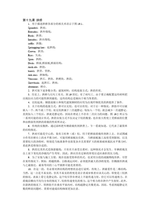
第十九课拱桥1.用于描述拱桥各部分的相关术语示于图19.1。
Spandrel:拱肩;Extrados:拱外缘线;Back:拱背;Intrados:拱内缘线;soffit:拱腹;Springging line:起拱线;Crown:拱顶;Rise:矢高;Span:拱跨;Deck:桥面,桥面板,桥面结构;Arch rib:拱肋;barrel:拱管,管拱;Arh axis:拱轴线;V oussoir:拱石、拱块,拱楔块,拱段;Skewback:起拱石,拱座;abutment:桥台。
2.拱可按下述参数分类:建筑材料;结构连接方式;拱的形状。
3.历史上,拱桥与石圬工有关。
到19世纪,有了砖圬工。
由于要正确配置这些材料把出现拉应力的可能性降到最低,这些结构总是倾向于相当笨重的。
4.比较起来,钢筋混凝土和现代建筑钢材的应用为出现纤细优美的拱提供了条件。
5.关于结构的连接方式,拱可以无铰,也可以有铰。
对于后一种情况,拱肋中可以被嵌入一个、两个或三个铰。
而无铰拱属于三次超静定,每加入一个铰,就会减少一次超静定,直到加入三个铰后,拱就是静定的,因而在理论上不存在二次应力的问题。
图19.2所示为一系列可能的设计形式。
拱的安装方式不仅决定于铰的数量,也在很大程度上受桥面的位置和由桥面传到拱的荷载的性质所决定。
6.传统的实腹拱,通过添料把车辆荷载传到拱背上,乍一看就知道,它代表了最简单的结构情况。
7.拱肩可能是空心的,装有立柱和(或)铰,用于把桥面荷载传到拱上去。
在试图减小作用在桥台上的水平推力时,可能用桥面板拉住拱。
当桥面板施工高度受到限制,以及需要较大的净跨时,特别是当地基条件也很复杂并且需要扩大的桩基础来抵抗水平推力时,系赶拱是特别合适的。
8.拱的完美形式是倒悬链线;只有在只承受自重时,这种情况才会发生。
车辆荷载及自上而下变化的净载均产生弯矩。
因此,拱应具有足够的厚度以适应曲折的压力线。
9.为了安装与施工方便,现在也接受简单的形式,也采用分段的或抛物线形拱。
毕设必备道路桥梁专业毕业设计英文翻译(英文原文+中文翻译)

Accident Analysis and PreventionThis paper describes a project undertaken to establish a self-explaining roads (SER) design programmeon existing streets in an urban area. The methodology focussed on developing a process to identifyfunctional road categories and designs based on endemic road characteristics taken from functionalexemplars in the study area. The study area was divided into two sections, one to receive SER treatments designed to maximise visual differences between road categories, and a matched control area to remainuntreated for purposes of comparison. The SER design for local roads included increased landscaping andcommunity islands to limit forward visibility, and removal of road markings to create a visually distinctroad environment. In comparison, roads categorised as collectors received increased delineation, additionof cycle lanes, and improved amenity for pedestrians. Speed data collected 3 months after implementationshowed a significant reduction in vehicle speeds on local roads and increased homogeneity of speeds onboth local and collector roads. The objective speed data, combined with r esidents’ speed choice ratings,indicated that the project was successful in creating two discriminably different road categories.2010 Elsevier Ltd. All rights reserved.1. Introduction1.1. BackgroundChanging the visual characteristics of roads to influencedriver behaviour has come to be called the self-explaining roads(SER) approach (Theeuwes, 1998; Theeuwes and Godthelp, 1995;Rothengatter, 1999). Sometimes referred to as sustainable safety,as applied in the Netherlands, the logic behind the approach isthe use of road designs that evoke correct expectations and drivingbehaviours from road users (Wegman et al., 2005; Weller etal., 2008). The SER approach focuses on the three key principlesof functionality, homogeneity, and predictability (van Vliet andSchermers, 2000). In practice, functionality requires the creation ofa few well-defined road categories (e.g., through roads, distributorroads, and access roads) and ensuring that the use of a particularroad matches its intended function. Multifunctional roadslead to contradictory design requirements, confusion in the mindsof drivers, and incorrect expectations and inappropriate drivingbehaviour. Clearly defined road categories promote homogeneity intheir use and prevent large differences in vehicle speed, direction,and mass. Finally, predictability, or recognisability, means keepingthe road design and layout within each category as uniform as possibleand clearly differentiated from other categories so that thefunction of a road is easily recognised and will elicit the correctbehaviour from road users. The SER approach has been pursued tothe largest extent in the Netherlands and the United Kingdom but ithas also been of some interest inNewZealand. In 2004, the NationalRoad Safety Committee and the Ministry of Transport articulateda new National Speed Management Initiative which stated “Theemphas is is not just on speed limit enforcement, it includes perceptualmeasures that influence the speed that a driver feels is appropriatefor the section of road upon which they are driving–in effect the ‘selfexplainingroad”’ (New Zealand Ministry of Transport, 2004).In cognitive psychological terms, the SER approach attempts toimprove road safety via two complementary avenues. The first is toidentify and use road designs that afford desirable driver behaviour.Perceptual properties such as road markings, delineated lane width,and roadside objects can function as affordances that serve as builtininstructions and guide driver behaviour, either implicitly orexplicitly (Charlton, 2007a; Elliott et al., 2003; Weller et al., 2008).This work is more or less a direct development of work on perceptualcountermeasures, perceptual cues in the roading environmentthat imply or suggest a particular speed or lane position, eitherattentionally or perceptually (Charlton, 2004, 2007b; Godley et al.,1999).A second aspect of the SER approach is to establish mentalschemata and scripts, memory representations that will allowroad users to easily categorise the type of road on which they are.1.2. Localised speed managementThe traditional approaches to improving speed management,traffic calming and local area traffic management (LATM) havefocussed on treating specific problem locations or “black spots”in response to crash occurrences or complaints from the public(Ewing, 1999). A potential disadvantage of these approaches is thataddressing the problem with localised treatments can lead to are-emergence of the problem at another location nearby. Further,when applied inappropriately, localised approaches may addressthe problem from only one perspective, without considering theimpact on other types of road users or residents. When traffic calmingtreatments rely on physical obstacles such as speed humpsthey can be very unpopular with bothresidents and road users andcan create new problems associated with noise, maintenance, andvandalism (Martens et al., 1997).From an SER perspective, treatments that are highly localizedor idiosyncratic may do more harm than good by adding to themultiplicity of road categories and driver uncertainty, rather thanbuilding driver expectations around a few uniform road types.Instead of considering a single location in isolation, SER roaddesigns are considered within a hierarchy of road functions; e.g.,access roads, collector roads, and arterial roads. Although SERschemes may employ physical design elements used in trafficcalming schemes (e.g., road narrowing with chicanes and accesscontrols) they also employ a range of more visually oriented featuressuch as median and edge line treatments, road markings,pavement surfaces, and roadside furniture. For an effective SERscheme it is important to select the combination of features that will afford the desired driver speeds and to ensure their consistentuse to form distinct categories of road types (van der Horst andKaptein, 1998; Wegman et al., 2005).road category that would meet the three SER principles of functional use, homogeneous use, and predictable use. Herrstedt (2006)reported on the use of a standardised catalogue of treatments compiledfrom researcher and practitioner advice. Goldenbeld and vanSchagen (2007) used a survey technique to determine road characteristicsthat minimise the difference between drivers’ ratingsof preferred speed and perceived safe speed and select road featuresthat make posted speeds “credible”. Aarts and Davidse (2007)used a driving simulator to verify whether the “essential recognisabilitycharacteristics” of different road classes conformed to theexpectations of road users. Weller et al. (2008) employed a range of statistical techniques, including factor analysis and categoricalclustering to establish the road characteristics that drivers use tocategorise different road types.The practical difficulties of implementing an SER system thusbecome a matter of finding answers to a series of questions. Howdoes one create a discriminable road hierarchy for an existingroad network? What road characteristics should be manipulatedto establish category-defining road features? How can SER roadfeatures and selection methods be made relevant and appropriatefor a local context? (Roaddesigns appropriate for The Netherlandswould not be suitable in New Zealand, in spite of its name.) A surveyof national and international expert opinion in order establishcategory-defining road features for New Zealand roads revealedthat the regional character and local topography of roads oftenundercut the usefulness of any standardised catalogue of designcharacteristics (Charlton and Baas, 2006).1.4. Goals of the present projectThe project described in this paper sought to develop anddemonstrate an SER process based on retrofitting existing roadsto establish a clear multi-level road hierarchy with appropriatedesign speeds, ensuring that each level in the hierarchy possesseda different “look and feel”. Rather than transferring SER designs already in use internationally, the project attempted to develop amethod that would build on the features of roads in the local area;extending road characteristics with desirable affordances to otherroads lacking them and creating discriminable road categories inthe process. Of interest was whether such a process could producecost-effective designs and whether those designs would be effectivein creating different road user expectations and distinct speedprofiles for roads of different categories.2. MethodsThe research methodology/SER design process developed forthis project progressed through a series of five stages: (1) selectionof study area; (2) identification of the road hierarchy; (3) analysisof the road features; (4) development of a design template; and (5)implementation and evaluation of the SER treatments. Each of thestages is described in the sections that follow.2.1. Selection of study areaThe study area for this project (Pt England/Glen Innes in Auckland)was selected in consultation with a project steering groupcomprised of representatives from the Ministry of Transport, NewZealand Transport Agency, New Zealand Police, and other localtransport and urban agencies. The study area was an establishedneighbourhood contained amix of private residences, small shops,schools, and churches, and was selected, in part, because of its historyof cyclist, pedestrian and loss of controlcrashes, almost twicethe number。
土木工程(道桥方向)专业外文翻译—路(公路)
毕业设计(论文)外文资料翻译系别:土木系专业:土木工程(道桥方向)班级:工077姓名:学号:外文出处:Prof essional Englishon Ci vilE ngineering M echanics附件:1、外文原文;2、外文资料翻译译文。
1、外文原文(复印件)Theroad(highway)The road i s one k indof l inearconstruction used for travel. It i s made of the roadbed, the roadsurface,thebridge,theculvertandthetunnel.Inaddition,italsohasthecrossingof lines, theprotective project and the traffic engineeringand the route facility.Theroadbedisthebaseofroadsurface,roadshoulder,sideslope,sideditchfoundations.Itisstonematerialstructure,whichisdesignedacc ording toroute'splaneposition.Theroadbed,asthebaseoftravel,mustguaranteethatit hasthe enough intensity andthe stability thatcanpreventthew a terand other natural disaster from corroding.The road surface is the surface of road. It is sing le or complex structure built w ithmix ture. Theroadsurfacerequirebeingsmooth,havingenoughintensity,goodstabilityandanti-slipperyfunction.The quality of road surface directly affects the safe, comfort and the traffic.The route marking i s one k indof traffic safety facility painted by oil paint or m adeby theconcreteandtilesonhigh-level,lesshigh-typesurface.Itsfunctioniscoordinatingthesigntomaketheeffectivecontroltothetransportation,directingthevehicle sskiproadtravel,servingunimpededandthesafepurpose.Ourcountry’s r oadroutemarkinghasthelanemedian l ine,thetrafficlaneboundary,thecurbline,theparkingline,theconductioncurrentbelt,thepedestriancrossingline,thef ourcornerscentercircle,theparkingazimuthline.Theroutemarkinghasthecontinualsolidline,thebroken l ineand the arrow indicator and itscolor uses the w hiteor the yellow.Thearchofbridgeisthe structurewhichstridesoverrivers,mountainvalleyandchannel.Itismade g enerallyby steel rod, concrete andstone.Thetunnelisthecavewhichconnectsbothsidesoftheroad.Thetechniqueofthisconstructionisverycomplex,thecostofthe projectsishigherthancommonroad.However,itreducesthe drivingdistancebetweentwoplaces,enhancesthegradeofthetechnicalinbuildingtheroadandguaranteesthe cars can drive fast and safely, thus reduces the cost of transportation.The protective project i s to protect and consolidate the roadbed in order that i t can g uaranteetheintensity and the stability of the road, thus maintains the automobile to pass throughsafely.In order to g uaranteethat safe operation of the highway transportation, besides the highwayengineeringandthevehiclesperformance,itmusthavesometrafficsignal,routemarking,eachkindofdirector anddemonstratefacility.Thehighwaymarkingusescertainmarkanddrawsymbol,simplewordsandnumber,theninsta llsinthesuitableplacetoindicatethe front road's condition or theaccidentconditionincludingtheinformationalsign,thewarningsignal,theprohibitorysign,theroadsig n and soon.The road w hichJoin city, village and industry, mainly are used for the automobile and hascertaintechnicalstandardandthefacilitypathcanbecalledthehighway.“T hehighway”in C hinesei sthemodernview,butitwasnotexistedinoldday.Itgetsthenamefromthemeaningofbeingusedforthepublictraffic.Whe rearethe human,therearetheroad.Itis a truth.However,the roadis notthehighway.Ifwetalkthehistoryabouttheroad,theearliesthighwayisthatbuiltbytheoldEgyptiansformakingthepyra mid.NextisthestreetwhichbuiltbytheBabylonpeopleabout4000yearsago.Allthese are much earlier than our country.A bout 500B .C ., the Persian Empire road has l inked up East and West, and connected the road toC hina. It i s the earliest and longest S ilkR oad. 2500 y ears ag o, i t mightbe the g reatestroad .Theancient R omeEmpire’s r oadw asoncecelebrated;i t took R omeasthecenter, a llaroundbuilt29roads.Thereforeitcameoutonecommonsaying:everyroadleadstoRome.The road's construction i s the process to enhance technique and renew the building materials.Theearliestistheoldroad,itiseasytobuildbutitisalsotodestroy.Ifthereistoomuchwaterorcars,itwillbeuneven andevenbedestroyed.ThemacadamroadappearedintheEuropewhichoutbalancedtheearliestmudroad.Thenthebri ckroadappearedwhichwasearlierthanChina.Itwasonegreatbreachthatwemoldedbitumenonthemacadamroad.Fro mancienttimestothepresent,Chinahascourierstationandcourierroad,whilethefirstmoreadvanceroadwastheonetha tfromLongZhouinGangXitoZhenNanGuanin1906.The difference betweenR oad and pathThe path i s the project for each k indof vehicles and people to pass through. A ccordingto itsfunction,wecandivideitintotheurbanroad,theroad,thefactoriesandminespath,theforestroadand county road.The classification of roadFirst, according to administrative rank, i t includes national highway, province road, countyroadand the special road. Generally the national highway and province road are named main l ine; thecounty road i s named branch line.The national road i s the m a in l ineand has political and economy s ignificance, includingtheimportantnationaldefenseroadandtheroadcollectingourcapitalwithotherprovinces,autonomousregi onsandmunicipalities.Itisalsotheroadlinkstheeconomycenter,seaporthinge,factoryandimportant strategicplace. The highway striding over different provinces are built, protected andmanagedby the special org anizationsw hichare approved by the ministry of communications.The provincial road i s the main l inebuilt, protected, managedby the road manage department.Iti s full of political and economic sense to the w hole province.The sing le w ay four levels of roads can adapt below each day and nightmedium-duty truckvolumeoftraffic200.The county route is refers to has county -w ide ( county -level city ) politics,theeconom-icsignificance,connectsinthecountyandthecountythemaintownship(town),theprin-cipalcommoditiesproductionandthecollectionanddistributioncenterroad,aswellasdoesnotbelongtothefederalhig hway,provincialroad'scountybordertheroad.Thecoun-tyroutebythecounty,thecityroad Departmentresponsible for the w orkis responsibleto construct, the maintenance and the management.The tow nshiproad refers to mainly the road w hichfor the tow nship( tow n) thev i l la -g eeconomy,theculture, the administration serves, as w ell as does not belong to above t-hecountyroutebetweenroad's townshipandthetownshipandthe townshipandthe exte-riorcontactroad.Townshipisresponsible by the people's governmentto construct, the m-aintenanceand themanagement.The special-purpose road i s refers to feeds specially or mainly supplies the factoriesandmines,theforestregion,thefarm,the oilfield,the touristarea,themilitaryimportantplaceandsoonandtheexternalrelationsroad.Thespecial-purposeroadisresponsiblebythespecial-purpose unit toconstruct,themaintenanceandthemanagement.Mayalsoentrustthelocalroad departmenttoconstruct, the maintenance and the management.S econd, according to the use duty, the function and adapts the volume of traffic division.A ccordingto our country present "Highway engineering Technical standard" theroadaccordingto the use duty, the function and the adaptation volume of tra-fficdividesinto highway,arterialroad,second-class road, tertiary highway, four level of road five ranks:1 st, the highway to feed specially the automobile and should control the differencec-ompletelyrespectively tow ardthe dividing strip on roads travel the multiple highway.The four traffic lane highway s oughtto be able to adapt each k indof automobile reduce passengervehicle'syearmeandiurnalvolumeoftraffic25000~55000.Thesixtrafficlanehighwaysoughttobeabletoadapteachkindofautomobilereducepassengervehicle'syearmean diurnalvolumeoftraffic45000~80000.The eighttraffic lane highway s oughtto be able to adapt each k indof automobiler-educepassengervehicle'syearmeandiurnalvolumeoftraffic60000~100000.2 nd, the arterial road to supplythe automobile and mayaccording to need to control thedifferencerespectivelytowardthe dividingstriponroadstravelthemultiplehighway.The four traffic lane arterial roads oughtto be able to adapt each k indof automobilreducepassengervehicle'syearmeandiurnalvolumeoftraffic15000~30000.The six traffic lane arterial roads oughtto be able to adapt each k indof automobilereducepassengervehicle'syearmeandiurnalvolumeoftraffic25000~55000.3rd,thesecond-classroadtosupplytheautomobiletravelthetwo-lanehighway.Canadapteachdayandnights3000~7500medium-dutytruckvolumeoftrafficgenerally.4 rd, tertiaryhighway s to mainly supply the automobile travel the two-lane highway.Canadapteachdayandnights1000~4000medium-dutytruckvolumeoftrafficgenerally.The5,fourlevelsofroadstomainlysupplytheautomobiletravelthetwo-laneorthesingle-lanehighway.The two-lane four levels of roads canadapt below each day and nightmedium-dutytruckvolumeoftraffic1500.Highway engineeringincludes Highway planning location design and maintenance. B eforethedesignandconstructionofa newhighwayorhighwayimprovementcanbeundertakentheremintbegeneralplaningandconsiderationoffinancingA spartofgeneralplanningitisdecidedwhatthetrafficneedofthereawillbeforaconsiderableperiod,generally20years,andwhatconstructionwillmeetthoseneeds.Toassesstrafficneedsthehighwaye ngineercollectsandanalyzesinformationaboutthephysicalfeaturesofexistingfacilities,thevolume,distribution,an dcharacterofpresenttraffic,andthechangestobeexpectedinthesefactor.Thehighwayengineermust determine the most suitablelocation lay out, and capacity of the new route and structures. Frequently, a preliminary l ineor locationand several a l ternate routes are studied. The detailed design i s normally beg un only w henthe preferredlocation has been chosen.In selecting the best route, careful consideration i s g ivento the traffic requirements terrain tobetraversedvalueoflandneededfortheright-of-way.andestimatedcostofconstructionforthevariousplans.Thephotogrammetricmethod,whichmakesuse ofaerialphotographsisusedextensivelytoindicate the character of the terrain on la rg e projects w here i t is most economical. On small project,Financing considerations determine w hetherthe project can be carried out t\t one time or whetherconstructionmustbeinstageswitheachstageinitiatedasfundsbecomeavailable.Indecidingthebestmethodof financingthe work, the engineermakesan analysis of whomit willbenefit.Importanthighway s and streets benefit* in vary ingdegrees, three g roups* users ow nersof adjacent property andthe g eneralpublic.U sersof improved highway s benefit from decreased cost of transportation, g reater travelcomfort,increasedsafetyandsavingoftime.Theyalsoobtainrecreationalandeducationalbenefits.Ownersofab uttingoradjacentpropertymaybenefitfrombetteraccess,increasedpropertyvalue,moreeffectivepoliceandfireprot ection,improvedstreetparkinggreaterpedestriantrafficsafety,andtheuseofthestreet rig ht-of-w ay for the location of public utilities such as w a terl inesand sewers.Evaluation of various benefits from highway construction i s often difficult but i s a m ostimportantphaseofhighwayengineering.Somebenefitscanbemeasuredwithaccuracy,buttheevaluationofothersismorespeculative.Asaresultnumerousmethodsarcusedtofinanc econstruction,andmuchengineeringw orkmay heinvolved in selecting the bestprocedure.Environmental evaluation. The environmental impact of constructing highway s hasreceivedincreasedattentionandimportance.Manyprojectshavebeendelayedandnumerousotherscanceledbec auseotenvironmentalproblems.Theenvironmentalstudyorreportcoversmanyfactors,includingnoisegeneration, airpollutiondisturbanceofareastraverseddestructionofexisting housing andpossible a l ternateroutes.Highway engineersmust a l so assist in the acquisition of rig ht-of-w ay needed for new highwayfacilitiesAcquisitionofthelandrequiredforconstructionofexpresswaylendinginto the centralbusiness areas of cities has proved extremely difficult ithe public i s demanding that traffic engineersworkcloselywithcityplanners,architects,sociologistsandallgroupsinterestedinbeautificationandimprove mentofcitiestoassurethatexpresswaysextendinxthroughmetropolitanareasbebuiltonlyafter coordinated evaluation of a l lmajor questions, including the follow ing;( 1 ) Is sufficient a ttentionbeing paid -to beautification of the ex pressway itself? ( 2 ) Wouldachangeinlocationpreserve major natural beauties of the city? (3) Coulda depressed design helogicallysubstitutedforthosesectionswhereanelevatedexpresswayisproposed?(4)Canthegeneraldesignheimpro vedtoreducethenoisecreatedbylargevolumesoftraffic?(5)Aresomesectionsofthe city being isolatedby the proposed location?Detailed design. Detailed design of a highway project includes preparation of draw ingsorblueprintstobeusedforconstruction.Theseplansshow,forexample,thelocation,thedimensionsofsucheleme ntsasroudwaywidth*thefinajprofilefor(heroad,thelocationandtypeofdrainagefacilities, and the quantities of w orkinvolved, including earthworkand surfacing.In planning the g radingoperations the design engineer considers the ty pe of material tobeencounteredinexcavatingorincuttingawaythehighpointsalongtheprojectandhowthe rnaterialremovedcanbestbeutilisedforfillorforconstructingembankmentsacrosslow areaselsewhereontheproject.Forthistheengineermustanalyzethegradationandphysicalpropertiesofthesoil,determ inehowtheembankmentscanbestbecompacted,andcalculatethevolumeofearthworktobedone.Electroniccalculati ngproceduresarenowsometimesusedforthelaststep.Electronicequipmenthas alsospeededupmanyotherhighwayengineeringcalculations.Powerfulandhighlymobile earth moving machines have been developed TO permit rapid and economical operations., S e lection of the ty peand thickness of roudw ay surfacing to be constructed i s an importantpartofdesign.Thetypechosendependsuponthemaximumloadstobeaccommodated,thefrequencyofthese loadsandotherfactors.Forsome mures,trafficvolumemaybeso lowthatnosurfacingiseconomicallyjustifiedandnaturalsoilservesastheroadway.Astrafficincreases,asurfacingofsan dycluy,crushedslag,crushedstonecalichecrushedoystershells,oracombinationofthesemaybeapplied.Ifgravelisuse d,itusuallycontainssufficientclay andfinematerialtohelpstabilizethesurfacing.Gravel surfaces may be further stubilizedby application of calcium chloride, w hicha l so a ids incontrollingdust.AnothersurfacingiscomposedofPortlandcementandwatermixediutotheupperfewinchesofthesuhg radeandcompactedwithrollers.Thisprocedureforms A soil-cementbasethatcanbesurfacedwithbituminousmaterials.Roadwaysrocarrylargevolumes ofheavyvehiclesmustbecarefully designedand made of considerable thickness.M uchof highway engineeringi s devoted to the planingand construction of facilities to drainthehighwayorstreetandlocarrystreamsacrossthehighwayright-of-way.R emovalof surface w a terfrom the road or street i s know n a surface druiuage . It isaccomplishedbyconstructingtheroadsothatithasacrownandbyslopingtheshouldersandadjacentareassoastocontr oltheflowofwatereithertowardexistingnaturaldrainage,suchasopenditches,orintoastormdrainagesystemofcalehba sinsandundergroundpipes.Ifastormdrainagesystemisused,asitwouldbewithcitystreets,thedesignengineermustgivec onsiderationtotherntalareadrainingontothestreet,themaximumrateofrunoffexpected,thedurationofthedesignstor m,theamountofpondingallowableateachcarchbasin,andtheproposedspacingofthecatchbasinsalongthestreet.Fro mthisinformationthedesiredcapacityoftheindividualeatehbaxinandthesizeoftheundergroundpipingnetworkurcc alculated.Indesigningfacilitiestocarrystreamsunderthehighway theengineermustdeterminetheareato be drained the maximumprobableprecipitationoverthe drainage basin,thehighestex pectedrunoffrare.and then, using ( hit information, must calculate the required capacity of l li t: drainagestructure.Generally designs a remade adequate to accommodatenot only the la rgestflow ever recorded for thatlocation but the g reatestdischarge that might be expected under the most adverse conditions for ag iven number of years.Factor considered in calculating the expected flow through a culvert opening include size, length,andshapeoftheopening,roughnessofthewalls,shapeoftheentranceanddownstreamendoftheconduit, maxim um a l low able heightof w atera t the entrance, and w a terlevel a t theoutletM uchengineeringund construction w orkhas been done to provide rest stops a longmajorexpresswayroutes t especiallythenationalsystemofinterstatehighways.Thesefacilitiesmustbecarefullylo catedtopermiteasyandsafeexitandreturnaccesstothehighway.Manyunitshavebeenbuilt^sceniclocationsinforested areastopermitpicnicgroundsandwalkwaysthroughtheforest.These rest areas are especially beneficial to tho« e drivers traveling long distances w ithfewstops.. The control and reduction of noise a long busy routes, especially expressway s, has become animportantpartofhighwayengineering.Inmanycommunitieshighwallshavebeenhuiltalongeithersideoftheexpress way.Suchwallscanhecostlytoconstruct,hutcanproveverybeneficial,barrierscan reduce overall noise levels by over 50 %.Constructionoperations.Althoughmuchengineeringandplaningmustbedonepreliminarytoit,the actual construction i s normally the costliest part of making highway uudstreet improvements.W i l li t h e aw ardof a construction contract follow ingthe preparation of the detailed plansandspecifications t engineersgoontotheftiteandlayouttheproject.Aspartofthisstakingout.limitsofearthworkar e show n, location of drainage structures indicated, and profiles established.Heavy rollers are used to compact the soil or subgradebelow the roadway in order to eliminatelatersettlement.Pneumatictiredrollersandsheepsfootrollers(steelcylindersequippedwithnumerousshort steelteethorfeetJareoftenemployedforthisoperation.Vibratoryrollershavebeendevelopedandusedonsomeproject sinrecentyears.Onetypevibratesupto3400times/min,compactingtheunderlyingmaterial to an appreciabledepth.M a intenanceand operation. Highway maintenance consists of the repair and upkeep of surfacingandshoulders,bridgesanddrainagefacilities?signs,trafficcontroldevices,guardrails,trafficstripingonthep avement,retainingwalls,andside slopes. Additionaloperationsincludeicecontrol undsnowremoval,becauseitisvaluabletoknowwhysomehighwaydesignsgivebetterperformanceandprove less costly to maintain than others, engineerssupervising maintenance can offer valuableguidanceto design engineers. Consequently, maintenance and operation arc important parts ofhighwayengineering.2、外文资料翻译译文路(公路)公路是供汽车或其他车辆行驶的一种线形带状结构体。
