民用机场飞行区技术标准
飞行区围界技术标准

正文:1.0范围本标准规定了首都机场飞行区各类围界建设标准。
2.0规范性引用文件下列文件中的条款通过本标准的引用而成为本标准的条款国际民用航空公约—附件十七《民用航空运输机场安全保卫设施建设标准》《民用机场飞行区技术标准》3.0围界种类及适用范围3.1 围界种类钢筋网围界、砖墙围界、防窥板围界、临时围界3.2适用范围首都机场飞行区主要区域应钢筋网围界,其余因特殊原因需要可采用砖墙围界、临时围界及防窥板围界。
4.0围界技术参数4.1钢筋网围界4.1.1 围界桩柱及网片表面防腐年限不少于8年。
4.1.2围界桩柱应采用钢材制成,厚度≥2mm,截面60mm×60mm4.1.3 围界顶部应设有防翻越装置,并加装蛇腹型刮刀刺圈,刺圈支架≥60º,刺圈直径≥600mm,刺圈敷设间距20cm-25cm,应使用标准件与网片联接牢固。
4.1.4钢筋直径≥5mm相邻横筋间距≤100 mm,左右间距≤50 mm。
4.1.5网片与立柱联接部位应采用防拆、防盗形式并保证联接部位的牢固性,以防止从外部进行拆卸。
网片与立柱之间缝隙<10mm。
4.1.6围界网片下端应与地梁进行有效联结以增加围界网片整体强度,网片与地梁间隙≤2cm。
4.1.7钢筋网围界柱基础应采用现浇混凝土制成,截面500mm×500mm,总高800mm,其中高出地表部分300mm,地下埋深500mm。
相邻柱基础间应采用现浇混凝土地梁,地梁截面宽240mm、高500mm,其中高出地表部分300mm,地下埋深200mm,混凝土强度≥C-20。
4.1.8钢筋网围界含地梁、网片、刺圈,净高度≥3.2M。
4.2 砖墙围界4.2.1 砖墙围界包括墙体、蛇腹型刮刀刺圈,墙体应为实体结构并设有墙基或地梁,厚度≥370mm,净高≥2.5m每相隔不超过3m设一加强垛。
4.2.2 砖墙应水泥封顶,上端加装蛇腹型刮刀刺圈,安装要求同4.1.3条,刺圈支架应与墙体联接牢固,蛇腹型刮刀刺圈与刺丝必须使用标准件进行连接。
民用机场飞行区技术标准的引用格式

民用机场飞行区技术标准的引用格式下载提示:该文档是本店铺精心编制而成的,希望大家下载后,能够帮助大家解决实际问题。
文档下载后可定制修改,请根据实际需要进行调整和使用,谢谢!本店铺为大家提供各种类型的实用资料,如教育随笔、日记赏析、句子摘抄、古诗大全、经典美文、话题作文、工作总结、词语解析、文案摘录、其他资料等等,想了解不同资料格式和写法,敬请关注!Download tips: This document is carefully compiled by this editor. I hope that after you download it, it can help you solve practical problems. The document can be customized and modified after downloading, please adjust and use it according to actual needs, thank you! In addition, this shop provides you with various types of practical materials, such as educational essays, diary appreciation, sentence excerpts, ancient poems, classic articles, topic composition, work summary, word parsing, copy excerpts, other materials and so on, want to know different data formats and writing methods, please pay attention!一、引言民用机场是国家对外交往、旅客运输以及货物运输等重要场所,飞行区的技术标准对于保障飞行安全和提高运行效率至关重要。
飞行区技术标准2013版与2006版差异对照差异对照表

编号
新标准(2013 版)条款内容
旧标准(2006 版及 2009 修订内容)条款内容
体,特别是金属物体,会改变 ILS 天线发射的场强的图形。
备注
民航局要求整改期 பைடு நூலகம்(除要求的整改 期限外,其他均应 在 2015 年 8 月 1 日 前整改完成)
的车辆、航空器会对 ILS 空间信号造 成严重干扰。敏感区:为临界区延伸 的区域,ILS 运行过程中车辆、航空器 等在该区域的停放和活动必须受到管 制,以防止可能对 ILS 空间信号的干 扰。 c) Ⅱ类精密进行跑道:装有仪表着陆 系统和(或)微波着陆系统以及目视助 航设备,供决断高低于60 m但不低于 30 m和跑道视程不小于300 m时飞行的 仪表跑道; 2.39 仪表跑 道
为交通控制而设定的行进中的 飞机和车辆必须停住等待、直 一 个 管 制 员 要 求 停 才 到机场管制塔台发出放行指令 停,一个是必须停。 时才能继续前进的位置。 运转区 位于供飞机地面活动的地区 上,或突出于为保护飞行中的 飞机而规定的限制面之上的、 一切固定的(无论是临时的还 是永久的)和移动的物体,或 是这些物体的一部分。 新增 英文: manoeuvring area 解释一致,翻译叫法不 同。
d) 机坪的表面类型、机位编号和适用 机型; f) 进近程序的目视助航设备,跑道、 4 机坪——道面表面类型, 飞机 滑行道、机坪的标志和灯光系统,滑 机位; 6 进近程序的目视助航设备, 跑 行道和机坪的其他目视引导和控制设 道、滑行道、机坪的标志和灯 施,包括滑行等待位置和停止排灯, 光系统,滑行道和机坪的其他 目视引导和控制设施,包括滑 以及目视停靠引导系统的位置和类 行等待位置和停止排灯,以及 型。其中,目视进近坡度指示系统的 目视停靠引导系统的位置和类 资料应包括相关的跑道号码、系统类 型。 型、系统轴线不平行于跑道中线时的 位移角和位移方向(左或右) 、标称的
飞行区围界技术标准

正文:1.0范围本标准规定了首都机场飞行区各类围界建设标准。
2.0规范性引用文件下列文件中的条款通过本标准的引用而成为本标准的条款国际民用航空公约—附件十七《民用航空运输机场安全保卫设施建设标准》《民用机场飞行区技术标准》3.0围界种类及适用范围3.1 围界种类钢筋网围界、砖墙围界、防窥板围界、临时围界3.2适用范围首都机场飞行区主要区域应钢筋网围界,其余因特殊原因需要可采用砖墙围界、临时围界及防窥板围界。
4.0围界技术参数4.1钢筋网围界4.1.1 围界桩柱及网片表面防腐年限不少于8年。
4.1.2围界桩柱应采用钢材制成,厚度≥2mm,截面60mm×60mm4.1.3 围界顶部应设有防翻越装置,并加装蛇腹型刮刀刺圈,刺圈支架≥60º,刺圈直径≥600mm,刺圈敷设间距20cm-25cm,应使用标准件与网片联接牢固。
4.1.4钢筋直径≥5mm相邻横筋间距≤100 mm,左右间距≤50 mm。
4.1.5网片与立柱联接部位应采用防拆、防盗形式并保证联接部位的牢固性,以防止从外部进行拆卸。
网片与立柱之间缝隙<10mm。
4.1.6围界网片下端应与地梁进行有效联结以增加围界网片整体强度,网片与地梁间隙≤2cm。
4.1.7钢筋网围界柱基础应采用现浇混凝土制成,截面500mm×500mm,总高800mm,其中高出地表部分300mm,地下埋深500mm。
相邻柱基础间应采用现浇混凝土地梁,地梁截面宽240mm、高500mm,其中高出地表部分300mm,地下埋深200mm,混凝土强度≥C-20。
4.1.8钢筋网围界含地梁、网片、刺圈,净高度≥3.2M。
4.2 砖墙围界4.2.1 砖墙围界包括墙体、蛇腹型刮刀刺圈,墙体应为实体结构并设有墙基或地梁,厚度≥370mm,净高≥2.5m每相隔不超过3m设一加强垛。
4.2.2 砖墙应水泥封顶,上端加装蛇腹型刮刀刺圈,安装要求同4.1.3条,刺圈支架应与墙体联接牢固,蛇腹型刮刀刺圈与刺丝必须使用标准件进行连接。
民用机场飞行区技术标准(MH5001-2000)
UDCMH中华人民共和国行业标准P MH5001-2000民用机场飞行区技术标准Technical standards for airfield area of civil airports2000-04-03发布2000-07-01施行中国民用航空总局发布中华人民共和国行业标准民用机场飞行区技术标准Technical standards for airfield area of civil airportsMH5001-2000主编部门:中国民用航空总局机场司批准部门:中国民用航空总局施行日期:2000年07月01日关于发布民用航空行业标准《民用机场飞行区技术标准》的通知民航机发[2000]78号各管理局、省(区、市)局,机场(公司)、航空公司,各设计、咨询、监理、施工单位:为了适应民用机场发展的需要,由民航总局机场司会同有关单位对《民用航空运输机场飞行区技术标准》(MHJ1-85)进行了修订,同时,更名为《民用机场飞行区技术标准》,并已经民航总局审定。
现批准《民用机场飞行区技术标准》为强制性民用航空行业标准,编号为MH5001-2000,自2000年7月1日起施行。
原《民用航空运输机场飞行区技术标准》(MHJ1-85)同时废止。
本标准由民航总局机场司负责管理和解释。
中国民用航空总局二○○○年四月三日1 总则------------------------------------------------------------------------------------------------------------(1)2 术语、代号----------------------------------------------------------------------------------------------------(2)2.1术语-----------------------------------------------------------------------------------------------------(2)2.2代号-----------------------------------------------------------------------------------------------------(7)3 机场资料------------------------------------------------------------------------------------------------------(8)3.1航空数据-------------------------------------------------------------------------------------------------(8)3.2基准点和标高-------------------------------------------------------------------------------------------(8)3.3基准温度-------------------------------------------------------------------------------------------------(8)3.4主要设施资料-------------------------------------------------------------------------------------------(8)3.5道面强度------------------------------------------------------------------------------------------------(9)3.6跑道公布距离------------------------------------------------------------------------------------------(11)4物理特性-----------------------------------------------------------------------------------------------------(12)4.1跑道----------------------------------------------------------------------------------------------------(12)4.2升降带-------------------------------------------------------------------------------------------------(15)4.3跑道端安全区-----------------------------------------------------------------------------------------(17)4.4净空道和停止道--------------------------------------------------------------------------------------(17)4.5无线电高度表操作场地-----------------------------------------------------------------------------(18)4.6滑行道和滑行带--------------------------------------------------------------------------------------(18)4.7防吹坪-------------------------------------------------------------------------------------------------(23)4.8等待坪、跑道等待位置、中间等待位置和道路等待位置-------------------------------------(23)4.9机坪-----------------------------------------------------------------------------------------------------(24)4.10除冰设施----------------------------------------------------------------------------------------------(25)1.0.1 为使民用机场飞行区的规划和设计做到标准统一、技术先进、经济合理、安全适用,制定本标准。
民用机场飞行区技术标准
6目视助航设施6.1信号设施和标志6.1.1信号灯1机场管制塔台上,如未配备有能向飞行区地面上的吃机、车辆或人员发出目视信号的装备,应设置信号灯。
2信号灯应能发出红、绿、自三种颜色的灯光信号,并能:l)按照需要由人工操纵对准任何目标2)发出任何一种颜色光的信号,随之发出另外两种颜色光中的任何一种信号3)用三种颜色光中的任何一种传递莫尔斯电码信息,速度至少每分钟4个字4)颜色灯光信号应在CIE色度坐标系统的以下界限之内:绿色信号黄色界限y=0.726-0.726x白色界限x二0.650y蓝色界限y二。
390一。
171x红色信号紫色界限y=0.950-x黄色界限;二0.335白色信号黄色界限y二。
500蓝色界限x二。
285绿色界限y二。
440和y二0.150+0.640x紫色界限y二。
050*750x和y=0.3823光束的扩散角应不小于I°不大于3°,当信号灯准备在自天使用时颜色光的光强应不小于6000cd6.1.2标志的一般要求1各种跑道标志应为白色,各种滑行道标志、跑道掉头坪标志和飞机机位标志应为黄色。
机坪标志应颜色鲜明、并与飞机机位标志的颜色反差良好。
在夜间运行的机场,标志宜使用反光涂料。
标志的亮度系数和标志的颜色在CIE色度坐标系统内的界限应如F:白色紫色界限y=0.010+x蓝色界限,,二。
610一、绿色界限y二。
030十、黄色界限x二0.710一、亮度系数p二。
75(最小)黄色橙色界限y=0.108+0.707x白色界限y二0.910~、绿色界限r二1.35,一。
093亮度系数p二0.45(最小)2在两条跑道相交处,应显示较重要的那条跑道的标志,另一跑道的所有标志应予中断,但较重要的那条跑道的边线标志在相交处可以连续也可以中断。
跑道重要性的顺序为精密进近跑道,精密进近跑道,非仪表跑道。
在与滑行道相交处,应显示跑道的各种标志,只有边线标志可以中断,而滑行道的各种标志均应中断。
标准修订解读——呼之欲出的MHT 5001-2020《民航机场飞行区技术标准》
标准修订解读| 呼之欲出的MH/T 5001-2020《民航机场飞行区技术标准》一、概述《民航机场飞行区技术标准》是民航机场设计时最经常翻阅的行业标准,同时也是全国一级建造师执业资格考试民航机场工程专业涉及到的最重要的标准之一,现行有效版本为MH 5001-2013,但近期中国民用航空局(CAAC)机场司组织中国民航机场建设集团有限公司全面修订了《民用机场飞行区技术标准》(MH 5001-2013),该修订稿(MH/T 5001-2020)已经过专家组初审,形成了征求意见稿,于2020年1月21日面向各方正式征求有关意见。
二、标准拟升版的背景MH 5001-2013《民用机场飞行区技术标准》于2013年07月31日正式发布至今已有六年多了,在此期间,无论国际上还是国内民用机场的建设都得到了飞速的发展,原有标准中的一些内容已不再适合行业现状,由此,MH 5001-2013的修订可谓势在必行。
1、国际行业标准动态《民用机场飞行区技术标准》编制的主要参考依据为ICAO的《国际民用航空公约附件14——机场》第I卷《机场设计和运行》,其第八版已于2018年7月正式出版,第八版自2018年11月8日起取代附件14第I卷所有以前的版本,其中对于“机场基准代号”、“跑道宽度”、“跑道道肩宽度”、“升降带宽度”、“滑行道宽度”、“滑行道最小间距”、“滑行道道肩”等有关内容都作了修改,改动较大,具体第八版修订条文的差异可参见《ICAO<国际民用航空公约附件14——机场>第I卷<机场设计和运行>第八版修订条文差异解读》。
《国际民用航空公约附件14——机场》第I卷《机场设计和运行》第八版的出版是《民航机场飞行区技术标准》升版的主要推手。
鉴于全球民航机场建设行业的发展迅速,国际民航组织对附件14第I卷的新一轮修订工作又已完成并征询了各国意见,拟议修订(第九版)预计于2020年11月5日起适用,最新的修订内容可参见《对附件14第I卷进行修订和对附件4、<空中航行服务程序—机场>(Doc9981号文件)和<空中航行服务程序—航空情报管理>(Doc10066号文件)进行相应修订的提案》的附篇B。
飞行区等级指标

飞行区等级指标
一、飞行区等级概述
飞行区等级是指机场飞行区的运行标准和安全要求,它主要反映了机场的运行能力、飞行保障设施和服务水平。
飞行区等级是机场规划、设计、建设和管理的重要依据,对于确保航空器安全、提高机场运行效率具有重要意义。
二、飞行区等级的划分与分类
根据国际民航组织(ICAO)的规定,飞行区等级分为两类:A类和B类。
A类飞行区等级主要包括仪表着陆系统(ILS)和非精密着陆系统(NPA),B 类飞行区等级主要包括目视飞行规则(VFR)和精密着陆系统(MLS)。
此外,我国还根据实际情况,将飞行区等级划分为三个等级,分别为1类、2类和3类。
三、飞行区等级的影响因素
飞行区等级受多种因素影响,主要包括机场的地形、气候、跑道长度、机场运行范围和航空器类型等。
这些因素共同决定了飞行区的运行能力和安全水平,从而影响了飞行区等级的划分。
四、我国飞行区等级标准及应用
我国飞行区等级标准分为三类,分别为1类、2类和3类。
1类飞行区主要适用于中小型机场,2类飞行区适用于中大型机场,3类飞行区适用于大型机场。
各类飞行区的运行标准和安全要求有所不同,具体应用时需根据实际情况进行选择。
五、飞行区等级提升的方法与策略
要提高飞行区等级,首先需要加强基础设施建设,如跑道延长、新建航站楼等。
此外,还需提高飞行区运行管理水平,引入先进的导航设备和飞行技术,如精密着陆系统(MLS)、卫星导航技术等。
同时,加强飞行员和地勤人员的培训与素质提升,确保飞行安全。
六、总结
飞行区等级是衡量机场运行能力和安全水平的重要指标。
新版《民用机场飞行区技术标准》变化情况

8.2.16.7
无说明
停止线应设在对正位于拟定的停止点上的左座驾驶员座席位置并与对准线成直角。其长度应不小于2 m,宽度应不小于0.15 m。如果需要一条以上的开始转弯线和(或)停止线,应对它们分别编码。机位停止线旁应标注停放机型的编码,机型编码的文字方向宜与飞机停放方向相反,文字采用黄色,字高宜为0.2 m~0.3 m,字符宽度按信息标志的比例缩小,如图41所示。
8.
作为跑道出口的滑行道(含快速出口滑行道和垂直滑行道),该滑行道中线标志应以曲线形式转向跑道中线标志,并平行(相距0.9 m)于跑道中线延伸至超过切点60m处
作为跑道出口的滑行道(含快速出口滑行道和垂直滑行道),该滑行道中线标志应以曲线形式转向跑道中线标志,并平行(相距0.9 m)于跑道中线延伸至超过切点一定距离,此距离在飞行区指标Ⅰ为3或4时应不小于60 m,飞行区指标Ⅰ为1或2时应不小于30 m(如图15和图16所示)。
注:A为4 m,B为5 m,C随字符宽度而定,D为0.1 m,E为2 m。如果空间受限,A,B,E可缩小一半。
28.
8.2.16.5
引入线、转弯线和引出线的转弯半径应适用于拟使用这些标志的要求最严格的飞机。这些线一般应为连续的实线,线条宽度不小于0.15m,如果准备让飞机只沿一个方向前进,则应在线条上增加前进方向的箭头,箭头长度应为线条宽度的10倍,尾部的宽度应为线条宽度的3倍
Ⅱ类或Ⅲ类精密进近跑道的中线标志宽度应不小于0.9 m;Ⅰ类精密进近跑道及非精密进近跑道的中线标志宽度应不小于0.45 m,其他跑道应不小于0.3 m。
4.
8.2.4.4
入口标志的线段应横向布置至距跑道边不大于3 m处,或跑道中线两侧各27 m处,以得出较小的横向宽度为准。这些线必须连续横贯跑道
民用机场飞行区技术标准
UDCMH中华人民共和国行业标准PMH5001-2000民用机场飞行区技术标准Technical standards for airfield area of civil airports2000-04-03发布 2000-07-01施行中国民用航空总局发布中华人民共和国行业标准民用机场飞行区技术标准Technical standards for airfield area of civil airports MH5001-2000主编部门:中国民用航空总局机场司批准部门:中国民用航空总局施行日期:2000年07月01日关于发布民用航空行业标准《民用机场飞行区技术标准》的通知民航机发[2000]78号各管理局、省(区、市)局,机场(公司)、航空公司,各设计、咨询、监理、施工单位:为了适应民用机场发展的需要,由民航总局机场司会同有关单位对《民用航空运输机场飞行区技术标准》(MHJ1-85)进行了修订,同时,更名为《民用机场飞行区技术标准》,并已经民航总局审定。
现批准《民用机场飞行区技术标准》为强制性民用航空行业标准,编号为MH5001-2000,自2000年7月1日起施行。
原《民用航空运输机场飞行区技术标准》(MHJ1-85)同时废止。
本标准由民航总局机场司负责管理和解释。
中国民用航空总局二○○○年四月三日目录1 总则------------------------------------------------------------------------------------------------------------------(1)2 术语、代号--------------------------------------------------------------------------------------------------------(2)2.1术语-------------------------------------------------------------------------------------------------------------(2)2.2代号-------------------------------------------------------------------------------------------------------------(7)3 机场资料------------------------------------------------------------------------------------------------------------(8)3.1航空数据-------------------------------------------------------------------------------------------------------(8)3.2基准点和标高------------------------------------------------------------------------------------------------(8)3.3基准温度-------------------------------------------------------------------------------------------------------(8)3.4主要设施资料------------------------------------------------------------------------------------------------(8)3.5道面强度-------------------------------------------------------------------------------------------------------(9)3.6跑道公布距离-----------------------------------------------------------------------------------------------(11)4物理特性------------------------------------------------------------------------------------------------------------(12)4.1跑道----------------------------------------------------------------------------------------------------------(12)4.2升降带------------------------------------------------------------------------------------------------------(15)4.3跑道端安全区---------------------------------------------------------------------------------------------(17)4.4净空道和停止道------------------------------------------------------------------------------------------(18)4.无线电高度表操作场地-----------------------------------------------------------------------------------(18)4.6滑行道和滑行带-----------------------------------------------------------------------------------------(18)4.7防吹坪-----------------------------------------------------------------------------------------------------(23)4.8等待坪、跑道等待位置、中间等待位置和道路等待位置--------------------------------------(23)4.9机坪---------------------------------------------------------------------------------------------------------(24)4.10除冰设施-------------------------------------------------------------------------------------------------(25)1 总则1.0.1 为使民用机场飞行区的规划和设计做到标准统一、技术先进、经济合理、安全适用,制定本标准。
民用机场飞行区技术标准

民用机场飞行区技术标准民用机场飞行区技术标准是指民用机场飞行区建设和运行过程中应当遵循的技术规范和标准,其主要目的是确保飞行区的安全、高效运行。
民用机场飞行区技术标准的制定和执行对于保障航空安全、提高机场运行效率具有重要意义。
首先,民用机场飞行区技术标准涵盖了飞行区的规划设计、建设施工、设备配置、运行管理等方面的内容。
在飞行区的规划设计中,需要考虑飞机起降、滑行、停靠等操作的需求,合理规划跑道、滑行道、停机位等设施的布局,确保飞机运行的安全和高效。
在建设施工过程中,需要严格按照相关标准和规范进行施工,确保各项设施的质量和安全性。
同时,飞行区的设备配置和运行管理也需要符合相关标准,包括导航设备、通信设备、灯光设施等的配置和使用管理,以及飞行区的日常维护和管理。
其次,民用机场飞行区技术标准还涉及了飞行区的安全管理、应急救援等方面的内容。
飞行区的安全管理包括飞行区内的安全防护措施、应急预案的制定和实施、飞行区安全检查等内容,旨在预防和减少飞行事故的发生。
同时,飞行区应急救援体系的建立和实施也是民用机场飞行区技术标准的重要内容,确保在紧急情况下能够及时有效地进行救援和处置,最大限度地减少损失。
此外,民用机场飞行区技术标准还包括了飞行区的环境保护、噪音控制等内容。
在飞行区的建设和运行过程中,需要考虑周边环境的保护,采取相应的措施减少对周边环境的影响,保护生态环境。
同时,飞行区的噪音控制也是一个重要的问题,需要采取有效的措施减少飞机起降、滑行等操作产生的噪音,保障周边居民的生活质量。
总之,民用机场飞行区技术标准涵盖了飞行区建设和运行的方方面面,其制定和执行对于保障航空安全、提高机场运行效率具有重要意义。
各个相关单位和人员都应当严格遵守相关标准和规范,共同努力确保飞行区的安全、高效运行。
民用机场飞行区技术标准

民用机场飞行区技术标准民用机场飞行区技术标准是民航行业的重要标准之一,它直接关系到飞机的起降、停靠、滑行等飞行区活动的安全和顺畅进行。
飞行区技术标准的制定和实施,对于提高机场运行效率、保障航空安全、提升服务质量具有重要意义。
首先,民用机场飞行区技术标准应包括以下内容:1. 跑道和滑行道的设计标准,包括跑道长度、宽度、强度等要求,以及滑行道的布置、标线标志等规定。
2. 飞机停机位的设置标准,包括停机位的数量、位置、布局等要求,以及地面设施的配置和服务设施的配备。
3. 飞行区灯光和标志的设置标准,包括跑道灯、滑行道灯、标志灯等的类型、位置、亮度等要求,以及标志标线的规划和维护。
4. 飞行区交通管制的规定,包括飞行区的进出渠道、滑行路线、航空器地面运行的规范等要求,以及飞行区交通管制的程序和责任划分。
其次,民用机场飞行区技术标准的制定应当充分考虑以下因素:1. 飞机类型和运行需求,不同型号的飞机对飞行区的要求有所不同,因此在制定飞行区技术标准时,应充分考虑各类飞机的特点和运行需求。
2. 地理环境和气象条件,不同地区的地理环境和气象条件对飞行区的设计和使用有着重要影响,飞行区技术标准应根据实际情况进行科学制定。
3. 安全和环保要求,飞行区技术标准应符合国际民航组织和国家相关法规的要求,保障飞行区活动的安全和环保。
最后,民用机场飞行区技术标准的实施应注重以下几个方面:1. 监管和管理,民用机场飞行区技术标准的实施需要相关部门进行监管和管理,确保标准的执行情况符合规定。
2. 培训和考核,机场相关人员需要接受飞行区技术标准的培训和考核,提高他们的专业水平和执行能力。
3. 不断完善,随着民航业的发展和飞机技术的进步,飞行区技术标准需要不断完善和更新,以适应新的需求和挑战。
总之,民用机场飞行区技术标准的制定和实施对于保障航空安全、提高机场运行效率具有重要意义,需要各方共同努力,确保标准的科学性、合理性和有效性,为民航事业的发展贡献力量。
飞行区技术标准

飞行区技术标准
飞行区技术标准是指航空领域中对飞行区域的规范和要求,包
括飞行区的设计、建设、维护和管理等方面。
飞行区技术标准的制
定和执行,对于保障航空安全、提高飞行效率和保护环境具有重要
意义。
本文将就飞行区技术标准的相关内容进行详细介绍。
首先,飞行区技术标准涉及到飞行区域的设计和建设。
飞行区
的设计应考虑飞机起降、滑行、停放等操作的需求,同时要充分考
虑气象条件、地形地貌、环境保护等因素。
在飞行区建设过程中,
需要严格按照相关标准和规范进行,确保飞行区设施的安全性和可
靠性。
其次,飞行区技术标准对飞行区的维护和管理提出了要求。
飞
行区设施的维护工作包括跑道、滑行道、停机位、导航设施等的定
期检查、维修和更新,以确保其正常运行和安全性。
飞行区的管理
涉及到航空公司、机场管理部门等多方的协调与合作,要求各方严
格遵守相关规定,确保飞行区的正常运行和航空安全。
此外,飞行区技术标准还涉及到飞行区的环境保护和应急处置。
飞行区的建设和运营应当符合环保要求,减少对周边环境的影响,
保护生态环境。
同时,飞行区应建立健全的应急处置机制,对突发事件能够及时、有效地应对,保障航空安全。
总的来说,飞行区技术标准是航空领域中的重要规范和要求,对于飞行区的设计、建设、维护和管理都提出了具体的要求。
遵守和执行飞行区技术标准,是保障航空安全、提高飞行效率和保护环境的重要举措,也是航空行业发展的需要。
希望相关单位和人员能够严格遵守飞行区技术标准,共同维护好我国的航空安全和发展。
《民用机场飞行区技术标准》
《民用机场飞行区技术标准》
《民用机场飞行区技术标准》是中国民用航空局发布的规定民用机场飞行区建设及运行的技术标准文件。
该标准文件主要内容涵盖了机场飞行区规划设计、机场跑道、道面、标志标线、灯光设施、通信导航设备、飞行区运行管理等方面的技术要求。
《民用机场飞行区技术标准》的制定目的是为了确保民用机场的飞行区建设和运行符合国际标准和安全要求,保障飞行安全,提高机场的运行效率和服务质量。
该标准文件适用于各类民用机场的飞行区建设和运行管理,包括机场跑道、停机坪、航空器滑行道、航空器起降区等飞行区相关设施。
《民用机场飞行区技术标准》文件细化了飞行区各种设施的技术指标和技术要求,包括飞行区的尺寸、坡度、平整度、排水性能、照明设施等方面。
该标准文件要求民用机场飞行区必须按照国际标准建设和运行,满足飞行活动的安全要求,并注重环保、节能、经济等方面的考虑。
《民用机场飞行区技术标准》对机场飞行区的规划设计、建设、设备选择和维护等方面提出了详细的技术要求,是民用机场建设和运行的重要参考依据。
民用机场飞行区技术标准(MH5001—2013)
表示道面可供不受限制次数使用的承载强度的数字。
2.53
7
MH 5001—2013
主跑道 primary runway 在条件许可的情况下,比其他跑道优先使用的跑道。
2.54
道路等待位置 road-holding position
指定的可能要求车辆在此等待的位置。
2.55
跑道 runway
陆地机场内供飞机起飞和着陆使用的特定长方形场地。
内进近面、 内过渡面和复飞面, 以及与这些面邻接的升降带以上的空间, 的轻质量和易折的装置外,不允许任何固定的障碍物穿透。
在此空间内除了助航所需
2.51
铅垂高 orthometric height
某一点相对于大地水准面的高度。
注: 通常以平均海平面标高表示。
2.52
道面等级号 pavement classification number
不是设在跑道端部的跑道入口。
2.25
有效光强 effective intensity
闪光灯的有效光强等于在同样观察条件下产生同样视程的同色恒定发光灯的光强,单位为坎德拉 ( cd)。
2.26
椭球面标高 ellipsoid height
大地标高
geodetic height
点的椭球面外法线测量得到的该点相对于地球基准椭球面的高度。
等待坪 holding bay
跑道端部附近,供飞机等待或避让的一块特定场地,用以提高飞机地面活动效率。 2.34
保持时间 holdover time
除冰液处理后受保护的(已处理的)飞机表面上预计不致形成冰、霜或积雪的时间。 2.35
识别灯标 identification beacon
发出电码信号用以识别某一特定基准点的航空灯标。 2.36
《民用机场飞行区技术标准(第一修订案)》下机场布局优化探讨
收稿日期:2019-07-24作者简介:皇甫国晟(1986—),男,浙江奉化人,硕士研究生,工程师,研究方向为民用机场总图设计、城市道路路线设计。
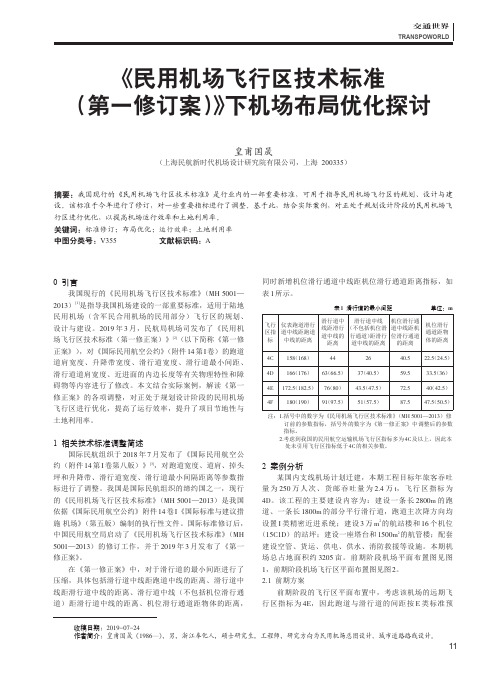
《民用机场飞行区技术标准(第一修订案)》下机场布局优化探讨皇甫国晟(上海民航新时代机场设计研究院有限公司,上海200335)摘要:我国现行的《民用机场飞行区技术标准》是行业内的一部重要标准,可用于指导民用机场飞行区的规划、设计与建设。
该标准于今年进行了修订,对一些重要指标进行了调整。
基于此,结合实际案例,对正处于规划设计阶段的民用机场飞行区进行优化,以提高机场运行效率和土地利用率。
关键词:标准修订;布局优化;运行效率;土地利用率中图分类号:V355文献标识码:A0引言我国现行的《民用机场飞行区技术标准》(MH 5001—2013)[1]是指导我国机场建设的一部重要标准,适用于陆地民用机场(含军民合用机场的民用部分)飞行区的规划、设计与建设。
2019年3月,民航局机场司发布了《民用机场飞行区技术标准(第一修正案)》[2](以下简称《第一修正案》),对《国际民用航空公约》(附件14第I 卷)的跑道道肩宽度、升降带宽度、滑行道宽度、滑行道最小间距、滑行道道肩宽度、近进面的内边长度等有关物理特性和障碍物等内容进行了修改。
本文结合实际案例,解读《第一修正案》的各项调整,对正处于规划设计阶段的民用机场飞行区进行优化,提高了运行效率,提升了项目节地性与土地利用率。
1相关技术标准调整简述国际民航组织于2018年7月发布了《国际民用航空公约(附件14第I 卷第八版)》[3],对跑道宽度、道肩、掉头坪和升降带、滑行道宽度、滑行道最小间隔距离等参数指标进行了调整。
我国是国际民航组织的缔约国之一,现行的《民用机场飞行区技术标准》(MH 5001—2013)是我国依据《国际民用航空公约》附件14卷I 《国际标准与建议措施机场》(第五版)编制的执行性文件。
国际标准修订后,中国民用航空局启动了《民用机场飞行区技术标准》(MH 5001—2013)的修订工作,并于2019年3月发布了《第一修正案》。
民用机场飞行区技术标准

民用机场飞行区技术标准民用机场飞行区技术标准是指对民用机场飞行区进行规范和标准化的技术要求,旨在确保飞行区的安全、高效运行。
飞行区是飞机起降、滑行、停放和其他地面活动的区域,其技术标准的制定和执行对于保障航空安全和提高机场运行效率具有重要意义。
首先,民用机场飞行区技术标准涉及飞行区的布局和设计。
飞行区的布局应考虑飞机起降、滑行和停放的流线性,确保各个区域之间的合理连接和交通流畅。
同时,飞行区的设计应符合飞机的起降和滑行要求,包括跑道长度和宽度、滑行道、停机位、滑行道路等的设计要求,以及相关的标志、标线和灯光设施的设置。
其次,民用机场飞行区技术标准涉及飞行区的材料和施工。
飞行区的材料应具有良好的耐久性、抗滑性和抗冲击性,以应对飞机起降和滑行过程中的高强度运载和磨损。
飞行区的施工应符合相关的工程标准和质量要求,确保飞行区的平整度、排水性和抗冻融性等满足技术标准的要求。
另外,民用机场飞行区技术标准还涉及飞行区的维护和管理。
飞行区的定期维护和检查是确保其安全运行的关键,包括对跑道、滑行道、停机位和相关设施的定期检查、修复和更新。
飞行区的管理应建立健全的管理制度和运行程序,保障飞行区的安全、有序和高效运行。
最后,民用机场飞行区技术标准还涉及飞行区的应急准备和应对。
飞行区应建立健全的应急预案和救援设施,以应对飞机失事、火灾、恶劣天气等突发情况。
飞行区的相关人员应接受应急处置的培训和演练,确保在紧急情况下能够迅速、有效地进行处置和救援。
总之,民用机场飞行区技术标准的制定和执行对于保障飞行区的安全、高效运行至关重要。
飞行区的布局和设计、材料和施工、维护和管理、应急准备和应对等方面的要求应得到严格执行,以确保飞行区的安全和高效运行。
同时,飞行区的相关人员应加强技术培训和管理,提高飞行区的整体运行水平,为民航事业的发展做出贡献。
飞行区技术标准
飞行区技术标准飞行区技术标准是指对飞机起降、滑行、停放等操作的技术要求和规范。
飞行区技术标准的制定,对于保障飞机安全运行、提高飞行效率、确保航空安全具有重要意义。
本文将就飞行区技术标准的相关内容进行详细介绍。
首先,飞行区技术标准包括了飞机起降所需的跑道长度和宽度、跑道标志、灯光、标线等要求。
这些标准的制定是基于不同类型飞机的起降性能、气象条件、飞机运行要求等因素进行综合考虑的结果。
飞机起降是飞行区的重要环节,合理的技术标准可以有效地保障飞机的安全起降。
其次,飞行区技术标准还包括了飞机滑行、停放区域的要求。
滑行道、停机位、滑行道标志、灯光等设施的设置和规范,对于飞机地面运行、停放、转弯等操作起着重要的指导作用。
合理的技术标准可以提高飞机地面运行的效率,减少飞机之间的冲突,确保地面安全运行。
另外,飞行区技术标准还包括了飞机地面服务设施的要求。
包括但不限于航空油料供给系统、通信导航设施、航空气象设备、消防救援设备等。
这些设施的设置和规范,直接关系到飞机地面服务的质量和效率,对于航空安全具有重要的保障作用。
最后,飞行区技术标准还包括了飞机地面运行的管理和监控要求。
包括但不限于航空交通管制、地面运行指挥、飞机地面运行监控等。
合理的管理和监控能够有效地协调飞机地面运行,减少事故发生的可能性,确保航空安全。
综上所述,飞行区技术标准是保障飞机安全运行、提高飞行效率、确保航空安全的重要保障。
各项技术标准的制定和执行,需要综合考虑飞机性能、气象条件、航空运行要求等多方面因素,力求科学、合理、严谨。
只有如此,才能有效地保障飞机地面运行的安全和顺畅。
- 1、下载文档前请自行甄别文档内容的完整性,平台不提供额外的编辑、内容补充、找答案等附加服务。
- 2、"仅部分预览"的文档,不可在线预览部分如存在完整性等问题,可反馈申请退款(可完整预览的文档不适用该条件!)。
- 3、如文档侵犯您的权益,请联系客服反馈,我们会尽快为您处理(人工客服工作时间:9:00-18:30)。
UDCMH中华人民共和国行业标准People’s Republic of China Technical Standard民用机场飞行区技术标准Technical standards for airfield area of civil airports中国民用航空总局CAAC Issued1总则General Principles1.0.1为使民用机场飞行区的规划和设计做到标准统一、技术先进、经济合理、安全适用,制定本标准。
The purpose of issuing the civil airport technical standard is in order to regulate the civil airport layout and design, uniform the standard, generally fit safety and economic requirements.1.0.2本标准适用于除直升机场以外的各类陆上民用机场的飞行区(含军民合用机场的民用部分)。
通用航空机场的飞行区参照本标准执行。
This standard of airfield area applies for all kinds of airport which constructed base on the terrene, not including the helicopter field. (For which covered the civil part of mili-civil mixed usage of the airport). The general aviation department’s operation will comply with this standard.1.0.3机场飞行区应按指标Ⅰ和指标Ⅱ进行分级,以使该机场飞行区的各种设施的技术标准能与在这个机场上运行的飞机性能相适应。
The airfield area should be separate into two Indexes in this case to adapt the different types of aircraft.飞行区指标Ⅰ:按拟使用机场跑道的各类飞机中最长的基准飞行场地长度,分为1、2、3、4四个等级,根据表1.0.3-1确定。
Index I: According to the necessary length of different aircraft’s Aeroplane Reference Field Length divided into four levels.表1.0.3-1 飞行区指标ⅠIndex I飞行区指标Ⅱ:按使用该机场飞行区的各类飞机中的最大翼展或最大主起落架外轮外侧边的间距,分为A、B、C、D、E、F六个等级,两者中取其较高等级,根据表1.0.3-2确定。
Index II: According to the aircrafts’ maximum wing span or the maximum space between the main landing gears’ outer limit divided into A、B、C、D、E、F six levels, select the higher number.表1.0.3-2 飞行区指标ⅡIndex II注:机型与飞行区指标关系见附录A。
1.0.4民用机场飞行区除应符合本标准外,尚应符合国家和行业现行的有关强制性标准的规定。
The civil airport should be abide with this standard and at mean time should tally with other complement standards which were issued by the ministry.2机场资料Airport Data2.1航空数据Aviation Data2.1.1 与机场有关的航空数据必须确定,需要确定的数据及其精度要求见附录B。
The data relevant to the airport must be confirmed and should be within the appropriate accuracy limit.2.1.2 机场地理坐标必须用经、纬度表示,并应提供以世界大地测量系统——1984(WGS-84)大地基准点为基准的数据。
The coordinate of the airport should be described in Longitude and Latitude, and the data which based on Geodetic Datum from the World Geodetic System1984(WGS-84)should be provided .2.2 基准点和标高Datum Point and Elevation2.2.1机场基准点Airport Datum Point机场必须设置一个基准点。
机场基准点应位于主跑道中线的中点,首次设定后应保持不变。
机场基准点的地理坐标必须加以测定,用经、纬度表示,精确至秒。
The airport datum point must be set. The airport’s datum point should locate in the midpoint of the main runway’s center line, when the datum point set it should remain unchanged. The coordinate of the airport datum must be menstruated and described as Longitude and Latitude, and should be accurate to the second.2.2.2 机场和跑道标高Airport and Runway Elevation机场标高指主跑道中线上最高点的标高。
机场标高以及该处的的大地水准面高差必须加以测定,精确至0.5米。
The airport elevation means the elevation of the highest point of runway center line.每个跑道入口、跑道端、非精密进近跑道中线最高点的和最低点、精密进近跑道接地带最高点的标高和大地水准面高差必须加以测定。
非精密进近,精度要求0.5米;精密进近,精度要求为0.25米。
For each runway threshold、runway end、Highest and Lowest point of the Non-Precision runway center line、Touch down zone elevation of Precision runway and the Geoid Undulation must be measured. The Non-Precision approach should be within 0.5 meters; Precision approach should be within 0.25 meters.2.3 基准温度2.3.1 机场必须确定一个基准温度,以摄氏度计。
3.3.2 机场基准温度应为一年内最热月(指月平均温度最高的那个月)的日最高温度的月平均值。
该温度应至少取五年的平均值3.4 主要设施资料3.4.1 机场内下列设施的有关资料必须提供:1 跑道的真向、磁向(精确至百分之一度),识别号码,长主、宽度,跑道入口内移的位置(精确至米),有效坡度,道面结构类型;Ⅰ类精密进近跑道是否设有无障碍物区;2 升降带、跑道端安全区、停止道的长度、宽度(精确至米)和表面类型;3 滑行道的编号、宽度、道面结构类型;4 机坪的长度、宽度、道面结构类型;5 净空道的长度(精确至米)、地面纵剖面;6 跑道、滑行道、机坪的标志和灯光系统;7 全向信标机场校准点的位置和无线电频率;8 标准滑行路线的位置和编号;9 仪表着陆系统的航向台和下滑台至跑道端的距离(精确至米)3.4.2 每个跑道入口中点和跑道中心点、滑行道各中线交点、飞机机位(鼻轮停止点)的地理坐标必须加以测定,用经、纬度表示,精确百分之一秒。
3.4.3 进近和起飞区、盘旋区和机场周围的重要障碍物的地理坐标必须加以测定,用经、纬度表示,精确至十分之一秒;并应提供各障碍物的顶端标高(精确至米)、类型、标志和灯光。
3.5 道面强度3.5.1道面的承载强度必须加以确定。
道面的承载强度采用包括下列内容的飞机等级号(ACN)——道面等级号(PCN)的方法确定:——道面等级号(PCN);——确定CAN-PCN的道面类别;——土基强度类型;——最大允许胎压;——评价的方法。
3.5.2 当飞机等级号(CAN)等于或小于道面等级号(PCN)时,能在规定胎压和飞机的最大起飞质量的条件下使用该道面。
如果道面强度受季节性影响有明显变化时,应相应确定不同的道面等级号。
当飞机等级号(ACN)大于道面等级号(PCN)时,在满足下述条件下可有限制地超载运行;1 道面没有呈现破坏迹象,土基强度未显著减弱期间;2 对柔性道面,飞机的ACN不超过道面PCN的10%;对刚性道面或以刚性道面为主的组合道面,飞机的ACN不超过道面PCN的5%;3 年超载运行的次数不超过年总的运行次数的5%。
3.5.3 确定飞机等级号和道面等级号的道面类别、土基强度类型、最大允许胎压类型和评定方法,应采用下列代号:1 道面类别道面类别代号刚性道面R柔性道面 F如道面结构是组合的或非标准类型时,应加以注解。
2 土基强度类型土基强度类型代号高强度: A刚性道面K=150MN/m3,代表大于120MN/ m3的K值;柔性道面CBR=15,代表大于13的CBR。
中强度: B刚性道面K=80MN/ m3,代表60~120 MN/ m3范围的K值;柔性道面CBR=10,代表8~13范围的CBR值。
低强度: C刚性道面K=40 MN/ m3,代表25~60 MN/ m3范围的K值;柔性道面CBR=6,代表4~8范围的CBR值。
特低强度: D 刚性道面K=20 MN/ m3,代表小于25MN/ m3范围的K值;柔性道面CBR=3,代表小于4的CBR值。
3 最大允许胎压类型:胎压类型代号高:胎压无限制W中:胎压限至1.50MPa X低:胎压限至1.00MPa Y特低:胎压限至0.5MPa Z 4 评定方法:评定方法代号技术评定:表示对道面特性进行理论评定。
