radan7使用指南中英文
radan7优点-20181025
RADAN 7优点1.RADAN7采用英文/中文界面2.RADAN7软件采用软加密,密码有效期为1年,1年后重新计算密码;用户可以选择在原电脑上继续使用软件并激活,或者用户可以更换电脑后安装软件RADAN7并进行激活。
3.RADAN7不再采用USB硬件加密狗。
1-1即用户不用随身携带USB硬件加密狗,1-2不存在忘记携带USB狗而不能使用软件处理资料的情况,1-3由于不再使用USB加密狗,而只采用软件加密方式,用户只需要携带安装了RADAN7软件笔记本计算机可处理资料。
4.RADAN7提高工作效率。
2-11套RADAN7软件最多能安装5台计算机,RADAN7软件安装在各笔记本计算机上以后,各计算机或者多套软件独立工作、分别使用,相互之间没有限制。
可以选则更多注册次数。
2-2即地质雷达检测工程师能够人手1台计算机自由使用RADAN7软件,在同一个工地上2台以上计算机安装了RADAN7软件,当有大量的地质雷达检测资料需要处理时,各个工程师可以同时处理资料,提高了工作效率。
2-3在不同的工地或者测区、地区进行地质雷达检测时,工程师能够随时并且及时处理资料,而不用把监测资料发送给持有RADAN7软件的工程师来处理,不用专门从其它工地现场借用地质雷达软件。
5.RADAN7软件提供了自动升级功能。
连接互联网时可以自动、手动升级处理软件至最新软件版本。
用户始终采用最新版功能。
6.RADAN7软件界面采用OFFICE 2010风格界面友好体验感增强。
7.RADAN7软件菜单可以随时切换,即打开或者关闭。
关闭菜单可以为雷达数据显示提供更多的屏幕空间,图像显示面积更大。
8.RADAN7可以识别主机系统的名称、普通天线的型号、智能天线的型号和序列号。
9.RADAN7软件增加了天线内置参数列表,包括天线型号,天线发射和接收间距,便于在计算电磁波传播速度以及目标体和地层深度中调用参数。
10.R ADAN7数据显示方面,数据显示颜色所用彩色更加丰富和细腻。
radan7使用指南中英文 甄选

radan7使用指南中英文(优选.)rdRadan 7 guide for data processingRadan 7数据处理指南1.设置数据路径。
菜单Home->window->properties对话框properties->global parameters ->File parameters->Source Directory2.数据文件加载与显示。
选择菜单->open或者快捷方式Ctrl+O,打开文件。
菜单Home->Color tables, color Xforms,设置颜色表格和颜色对比对。
3.数据编辑。
菜单processing->adjust scans->edit block设置start scan和end scan,选择block operation选项save保存,delete删除。
4.文件反向。
菜单G->Save as->radan file reversed.删除dzx数据库文件,并重新打开翻转后的dzt数据文件。
5.距离归一化。
6.添加里程信息。
Home状态下,选择tables。
Tables->profiles->start Dist(m),输入起始里程。
Tables->profiles->Dist decrem,选择此项,桩号从大到小。
7.水平刻度调整。
Processing->adjust scans->horizontal Scaling。
8.地面调整。
9.地面时间调整。
10.设置介电常数11.调整增益。
Processing->Gain->range gain。
Range gain->gain type选择automatic. # of points设置为5.Range gain->gain type选择Exponential. 手动设置增益值.12.水平信号增强。
Radan软件飞行切割功能使用说明

Radan软件飞行切割功能使用说明“飞行切割”是当前非常流行的先进高速切割加工方法,它是不采用引线,并将轮廓的切割起点放在激光头的运动轨迹的切线上,尽量减少切割时激光切割方向的变化,确保激光头在切割过程中一直处于高速运动的状态,以提高机床切割效率。
Radan 是英国RADAN公司于1976年开发研制的专业钣金件、结构件设计加工软件。
经过20多年的不断开发及改进,日趋成熟而完善。
如今已成为集设计、制造、管理于一体的模块化软件。
Radan软件可支持当前世界上所有品牌的钣金数控加工机床,包括冲、剪切、激光、冲―激光复合、火焰、等离子、水切割、数控折弯机等。
Radan 3D:Radan3D是一个高性能的通用的3D模型设计软件包,使得钣金设计和模型装配更简单。
它基于ACIS实体建模核心并使用现代的参数化技术,提供柔性化的设计及独有的2D-to-3D方法创建3维模型。
此外,Radan3D允许导入多种文件格式,包括Inventor, Solidworks, Catia V4&V5, SAT, IGES, STEP 及Parasolid,也可以在3D环境下创建装配。
Radan3D的展开是自动且柔性的。
无论是Radan3D设计的还是从其他系统导入的3D模型都可以很容易的展开为平板。
用户可以自定义折弯系数。
Radan 2D: Radan2D是一个全功能的2D绘图软件包,简单易用。
它提供DXF, DWG,IGES等格式的数据接口,可以批量的导入、导出图形,并同时对图形进行智能轮廓诊断(包括移除孤岛及微小图素、连接微小间隙、合并重叠图素、简化复杂轮廓等),直接得到适合数控加工的精确的、完整的图形。
Radan2D内建有特殊的钣金特征库,使2D设计更加简单方便。
Radan Punch:Radan冲加工模块通过其强大的功能为工程师及机床提供最大化的加工效率。
Radan冲加工模块提供了多种转塔布局定义功能,来适应不同生产的需要。
RADDY VP7专业天气站用户手册说明书

Manuals+— User Manuals Simplified.RADDY VP7 Professional Weather Station User Manual Home » RADDY » RADDY VP7 Professional Weather Station User ManualContents1 RADDY VP7 Professional Weather Station2 Features3 Weather Station Appearance4 Multi-combination Wireless Remote SensorAppearance5 Exterior6 Setup Preparation7 Quick Setup8 Alarm function control9 Alarm and Snooze settings10 Switching off the alarm signal11 Wind Readings History12 Rain Readings History13 Weather alert viewing and setting14 Background lighting15 Mounting Instructions (wireless sensor)16 Specification17 Documents / Resources17.1 ReferencesRADDY VP7 Professional Weather StationThank you for your purchase.Wind speed range: 0 to 180 km/h (0 to 111 mph)Wind direction range: 0 to 359 degreesWireless Outdoor Sensor.433.92MHz RF transmitting frequency100 meters (300 feet) transmission range in an open area, not including walls or floorsRecord of temperature, humidity, wind speed and rainfallAlert of temperature, humidity, wind speed, rainfallDisplay of feels-like temperature, wind chill temperature, heat index, and dew point temperature The weather forecasting functionLevel 3 display backlightUSB charging functionPower Supply:Weather station:Power Adapter: DC5V 1.2ABattery: 2 x LR3 AAA 1.5VMulti-combination Wireless Remote Sensor: Battery: 3 x LR6 AA 1.5VTemperature Humidity Wireless Remote SensorBattery: 2 x LR6 AA 1.5VF.Y.l.:The wireless remote sensor can work at -30°C to +70°C. Please choose the right battery according to the limited temperature of the wireless sensor:Alkaline zinc manganese battery can work at -20°C to +60°CPolymer lithium-ion rechargeable battery can work at -40°C to +70°CWeather Station Appearance Part A – Positive LCDExteriorC1: Hanging holeMulti-combination Wireless Remote Sensor AppearanceExteriorD1: Solar panelD3: Wind cupsD5: Temperature | humidity induction boxD7: Reset buttonE1: Hanging holemanually, you need to press and hold the ” ” button to exit the radio time mode, and then continue to the nextPress and hold the ” ” button for 3 seconds to enter the time setting mode.Press and release the “ ” or “ ” button to adjust the value. Hold the ” ” or ” ” button to adjust After 20 seconds without pressing any button or touching the” ” location button at any time toRCC signal, press and hold the ” ” button for 3 seconds to exit.The weather station will automatically perform an RCC signal search at 1:00 / 2:00 / 3:00 every day to correct lf you need to manually search for RCC signals, press and hold the “ ” button for 3 seconds to enter thePress and release the ” ” button to view the alarm 1 time, press and release the button to view the alarm 2 ln the mode of viewing the alarm 1 time or the alarm 2 time, press and release the “ ” button to control itsWhen the function of Alarm 1 or Alarm 2 is turned on, the symbol ” ” or “ ” is displayed. At the same time, the relevant alarm repeat symbol “ ” | ” ” is displayedAfter 20 seconds without pressing any button or touching the “ ” location button at any time toPress and hold the ” “button for 3 seconds to enter the alarm and snooze setting mode.Press and release the “ ” or ” ” button to adjust the value. Hold the “ ” or ” ” button to adjustPress and release the “ ” button to confirm and move to the next item.After 20 seconds without pressing any button or touching the location button at any time toThe alarm sounds when the trigger, presses any buttons except the ” ” touch button or touches and holds the ” ” button for more than 3 seconds to stop the alarm signal.When the time is up to the alarm, touch and release the ” ” touch button, the alarm signal stops, and In snooze timing mode, press any buttons except the ” ” touch button or hold down the ” ”Press and release the ” ” button to view High | Low temperature and humidity and feel like temperature,In the mode of viewing temperature | Humidity history, press and hold the “ “button for 3 seconds to clear all Note: After 20 seconds without pressing any button or touching the ” ” location button at any time toln the main display interface, press and hold the “ ” button for 3 seconds to convert the display to windPress and release the “ ” button to view the maximum wind historic values: 1 Hour (default) |ln the mode of viewing wind speed history, press and hold the “ ” button for 3 seconds to clear all history of After 20 seconds without pressing any button or touching the ” ” location button at any time to exit the ln the main display interface, press and hold the “ ” button for 3 seconds to convert the display to thePress and release the ” ” button to view the rain historyIn the mode of viewing rain history, press and hold the ” ” button for 3 seconds to clear all the history of rain.After 20 seconds without pressing any button or touching the “ ” location button at any time to exitPress and release the ” ” button to view the weather alerts mode. Continue to press and release the “ ”Note: After 20 seconds without pressing any button or touching the ” ” location button at any time toln each weather alert view item, press and hold the “ ” button to turn the alert on or off.Press and hold the ” ” button for 3 seconds to enter the weather alert setting mode.Press and release the ” ” or ” ” button to adiust the value. Hold the ” ” or ” ” button to adjust After 20 seconds without pressing any button or touching the “ ” location button at any time tocancel, press and release the “ ” button to set to OFF The weather station displays the following weather icon:If the product is powered by batteries, Touch the ” ” location button. The backlight lit for 15 seconds. disconnect the power supply. and the backlight will always be bright. Press the ” ” button to adiust theWhen the backlight brightness is not at the maximum brightness. press the “ ” button. Backlight tums If the “indoor sensor” column displays the battery icon ” “, you need to replace the weather station’s5. Reinstall the rainwater bucket.6. Note: Do not apply oil to the rain sensor.Note: Make sure the wireless sensor is installed within 100 meters of the weather station (empty, unobstructed). According to the thickness of the obstacle between the wireless sensor and the weather station, the distance should be shortened as much as possible(the distance after the wireless signal penetrates the obstacle will be shortened), otherwise, the data transmission may be disturbed.Temperature Humidity Wireless Remote Sensor (Optional sensor)Documents / ResourcesRADDY VP7 Professional Weather Station [pdf] User ManualVP7, VP7 Professional Weather Station, Professional Weather Station, Weather Station, StationReferencesRaddy Outdoor | Be prepared, get RaddyManuals+,。
Rand McNally TND 740 GPS导航器用户指南说明书

1Enter RV information and access RV-specifi c tools.2Show location on the map and view navigation instructions.3Choose a destination.4 Select general, route, and map preferences.Note: Some icons may not be present, depending on specifi c hardware. Main Menu 12341. Tap RV T ools > RV Info or Warnings.2. Tap and to view options.3. Tap the option button to be changed.4. Enter new settings.5. Tap to save changes.1. Tap Preferences .2. Tap the General , Route or Map tab.3.Tapand to view options.4. Tap the option button to be changed.5.Enter new settings.6. Tap to save changes.Enter RV Information and Set Warnings Set Routing and Device Options Destination1Return to a new location.2Return to a previously entered address.3Access the Address Book.4Plan a multi-stop trip. 5 Route to a point of interest.6 Run an Internet search for local businesses.(Note: This feature requires a Wi-Fi connection.)7 View trip content from Rand McNally.Run a local search near:8 Your RV9 A particular city10 Your destination 11 Search for local restaurants.12Access recent searches. 123456*********Route to a Destination1. Tap Choose Destination > New Location .2. Tap Address .3. Enter the name of the city. (Note: As you type, the keyboard displaysonly the next possible letter.)4. Prompts appear in the top bar. Tap the city to select. Or, tap List toview cities beginning with the letter(s) you entered.5. Enter the street name. (Note: If the letters you need do not appear,tap Expand Search.)6. Enter the house number. (Note: To enter the house number before the street, tap the house number button in the previous step.)Confi rm Destination Window1Destination address.2Begin route to destination.3Compare a primary and alternate route and choose one.4Add the location as a via point on the way to a previously entered destination.*5Save the location to the Address Book.6Cross reference to printed Rand McNally Road Atlas.7View the map.8Change the starting location for a route to the location displayed here.9View the map.10 Return to previous window.*To manage via points, Tap Choose Destination > Multi-Stop T rips .You can add up to 50 destinations in a multi-stop trip, and optimize routing for trips of up to 10 stops.NOTE: This window may include additional buttons based on the type of destination selected.14679810325See Confi rm Destination Window.T ips• You can also route to a new location by City Center , Intersection ,or Latitude/Longitude , or choose Address > Zip Code Search .• View recent destinations by tapping Choose Destination > History .View recent cities by tapping Choose Destination > New Location >Address > History .• View saved locations by tapping Choose Destination > Address Book .Repeat spoken next-maneuver instructions.2 Name of street you will turn onto next.3 Show arrival time, remaining time, or other options. 4Slide out to show upcoming exit information.5 Directions list slideout. Tap Route Display Optionsto select turn-by-turn, highway, trip summary, or summary map view. 6Zoom in/zoom out.7 Access Wi-Fi connected services.8 Return to Main Menu.9 Select a map display option (Heading Up, North Up, or 3D View).Also displays Wi-Fi status.10 View current road name, upcoming cross road name, or city, county and state.11 View and save current location, detour or cancel a route, or skip to the next stop.12 Tap on the current speed to display the Virtual Dashboard.Note: Turns red for speed warnings; set in RV T ools > Warnings .)13Current speed limit. Tap to open a “Tell Rand” about speed limits.14 View the Traffi c Window (enabled with Traffi c Everywhere).15 Mute or unmute the speaker.Route Map Window R 1134568792101112151413When on a route, Junction View displays when you have an upcomingmaneuver. Once past the maneuver, Junction View closes and theprevious window displays.1Signs to follow for the next maneuver.2Number and direction of lanes for the next maneuver.3 Distance to the upcoming maneuver. Distance decreases as youapproach the ramp.4 Lane assist arrow.5 Mute the speaker.6 Return to previous window.Junction View123456Tap Choose Destination > Points of Interest .1Find popular RV-friendly POIs near your current location.Search for a POI:2Near your RV 3In a particular city 4Along your route 5Near your destination POI Categories:6Select a category.7Find restaurants, hotels, and other subcategories.8View custom POIs such as red light cameras or other locations that have beenuploaded through the Rand McNally Dock.9Tap location to select.10View and edit ratings and comments.11Tap to search by available services.12Apply or remove services fi lter for search results.76813452Find a Point of Interest (POI)91011121Sunrise and sunset times based on vehicle location(latitude/longitude) and day.2Current speed.3 Elevation at current location.4 Percentage of current trip completed, distance to next maneuver, and the number of miles and time spent on the trip to this point.5 Match with the vehicle’s odometer to automatically update newfuel logs. Tap the pencil to edit.6 Gather trip information for up to three trips. Includes odometer settings, hours, and speeds.7 Reset trip information for the selected trip (Tab 1, Tab 2 or Tab 3).8 Select to automatically reset the information in each tab after the vehicle has remained stationary for the specifi ed number of hours.9 View fuel logs and add fuel purchase information.10 Return to the Route Map Window .134568792Virtual Dashboard10Tap RV T ools > Checklists, Maintenance, Trails, Fuel . Then tap on each tab to view.1Use Checklists to create and complete task lists to prepare for a trip.2Add notes in the Maintenance tab to record dates of service for your RV .3 Use Trails to record a “bread-crumb” path of GPS coordinateswhere your RV has traveled. Tap any record to view the trail, edit the name, or set the color.4 Use the Fuel tab to view a list of fuel purchases. Tap Add Fuelto record the date, location and cost of fuel purchase. Tap Save .Tap any record to make changes. (Note: This can be exported to your PC or Mac via the Rand McNally Dock.)Checklists, Maintenance, Trails, and Fuel 1234For information on setting up a Wi-Fi hotspot through your cellular phoneor laptop computer, please visit /wifi help forbasic instructions or contact your wireless carrier.Note: Wi-Fi connectivity requires a supporting feature and data planfrom your wireless service provider.As the user, you are responsible for all data charges. Please contact your wireless service provider to make sure you do not exceed thelimits of your data plan.Once you have established a Wi-Fi hotspot:1. From the Main Menu, tap Preferences.2. Tap WiFi in the bottom right corner.3. Tap Enable WiFi to search for available hotspots.4. Tap the hotspot you want to connect to.5. Enter the network password.6. Tap Disable WiFi to turn Wi-Fi connectivity off.Wi-Fi ®Weather, Fuel Prices, and Traffi c EverywhereNote : This feature requires a Wi-Fi connection.Tap the Wi-Fi connected services icon( ) on the map screen. Tap each tab to view live information.Weather:1Tap to view details for current weather alerts.2View weather information at your destination.3 Display weather on the map as you drive.Fuel Prices:4Check to show fuel prices on the map screen.5Sort results by distance or price.6Set fi lters for type and brand of fuel.7 Choose to search near your vehicle or along your route.Traffi c Everywhere:Live traffi c information is available as a premium service on theRand McNally Dock.4513267The Rand McNally Dock enables you to receive software upgrades and access map updates, monthly construction updates, and additional features. Simply download the Dock software for your PC or Mac at /dock, remove the SD card from your device and insert it into your PC or Mac using SD card adapter. Then start the Rand McNally Dock software.With the Rand McNally Dock, you can also:•Access the TripMaker ® Trip Planner •Purchase Traffi c Everywhere •Upload custom POIs, such as red light cameras and railroad crossings, to your device •Download the User Manual •Access the Rand McNally support site and online store •Read product news and announcements • Send feedback and suggestions to Rand McNally through “Tell Rand”For a detailed description of the features of your device, please see the RVND TM 7730 User Manual. The User Manual can be downloaded from the Rand McNally Dock, and is also available at /support .More InformationRand McNally Dock ™Warnings, End-User License Agreement, and WarrantyPay attention to road conditions and street signs, and obey all traffic and safety laws. Traffic laws and current traffic conditions must always be observed and take precedence over the instructions issued by the Rand McNally navigation system. The User should be aware of situations where current traffic conditions and the instructions from the navigation system may be in conflict. Some states prohibit the use of windshield mounts and may otherwise restrict the usage of navigation and other electronic devices in the vehicle. It is the User’s responsibility to ensure compliance with all laws and regulations. The use of the navigation system does not relieve the User of his/her responsibilities. The User is ultimately responsible for the vehicle under his/her control and should be aware of the surroundings at all times.If after reading these statements the User decides not to accept these terms, the User should not use the navigation system.Rand McNally hereby grants you (“User”) a single-user non-exclusive, non-transferable license to use the Rand McNally navigation system (hereinafter referred to as the “Product” (including software and associated data)) for User’s own internal business or personal use and not for resale, sublicense or commercial use.This Product and the software incorporated in it and related documentation are furnished under license and may be used only in accordance with this license. Except as permitted by such license, the contents of this Product and software may not be disclosed to third parties, copied or duplicated in any form, in whole or in part, without the prior written permission of Rand McNally. This Product and software contain proprietary and confidential information of Rand McNally and its licensors. Rand McNally grants User a limited license for use of this Product and the software incorporated in the Product for its normal operation. By using the Product, User acknowledges that the content of this document and the Product are the property of Rand McNally and its licensors and are protected by U.S. copyright, trademark and patent laws and international treaties.THE USER MAY NOT:• Use the Product on a network or file server, time-sharing or to process data for other persons.• Use the Product to create any routing tables, files, databases or other compendiums.• Copy, loan or otherwise transfer or sublicense the Product, its software or content.• Modify, or adapt the Product in any way, or decompile, disassemble, reverse engineer or reduce to human readable form the Product and software incorporated therein.• Alter, remove or obscure any copyright notice, trademark notice, or proprietary legend from the Product, its software or content.This license will terminate automatically if User fails to comply with any of the terms of this license and User agrees to stop using the Product. Rand McNally may revise or update the Product and is not obligated to furnish any revisions or updates to User.Caution: Rand McNally makes no warranty as to the accuracy or completeness of the information in the Product and disclaims any and all express, implied or statutory warranties, including any implied warranty of merchantability or fitness for a particular purpose. It is the user’s responsibility to use this product prudently. This product is intended to be used only as a travel aid and must not be used for any purpose requiring precise measurement of direction, distance, location or topography.RAND MCNALLY AND ITS LICENSORS DO NOT MAKE ANY OTHER WARRANTY OR REPRESENTATION, EITHER EXPRESS OR IMPLIED, WITH RESPECT TO THE PRODUCT, INCLUDING ANY WARRANTY AS TO QUALITY, PERFORMANCE, TITLE OR NON-INFRINGEMENT. IN NO EVENT WILL RAND MCNALLY OR ITS LICENSORS BE LIABLE FOR ANY INDIRECT, SPECIAL, INCIDENTAL, OR CONSEQUENTIAL DAMAGES ARISING OUT OF THE USE OR INABILITY TO USE THE PRODUCT, EVEN IF ADVISED OF THE POSSIBILITY OF SUCH DAMAGES.Some states do not allow limitations on how long an implied warranty lasts and/or do not allow the exclusion or limitation of incidental or consequential damages, so the above limitations may not apply to some consumers.The User agrees to allow User-provided information to Rand McNally to be used for internal business evaluation purposes, including, but not limited to, evaluating the effectiveness of the services provided, methods to simplify or improve User experiences. Such information will not be used by third parties or in any way that discloses the identity of the User.Rand McNally may make use of third party software in the Product. Notwithstanding the terms and conditions of this license, use of some third party materials included in the Product may be subject to other terms and conditions. The official third party copyright notices are provided at the end of this License.The User agrees to indemnify, defend and hold Rand McNally and its licensors (including their respective licensors, suppliers, assignees, subsidiaries, affiliated companies, and the respective officers, directors, employees, shareholders, agents and representatives of each of them) free and harmless from and against any liability, loss, injury (including injuries resulting in death), demand, action, cost, expense or claim of any kind or character, including but not limited to attorney’s fees, arising out of or in connection with any use or possession by the User of this Product.These terms and conditions constitute the entire agreement between Rand McNally (and its licensors and suppliers) and the User pertaining to the subject matter hereof, and supersedes in their entirety any and all written or oral agreements previously existing between us with respect to such subject matter.The above terms and conditions shall be governed by the laws of the Illinois, without giving effect to (i) its conflict oflaws provisions, or (ii) the United Nations Convention for Contracts for the International Sale of Goods, which is explicitly excluded. The User agrees to submit to the jurisdiction of Illinois for any and all disputes, claims and actions arising from or in connection with the Data provided to the User hereunder.User shall not export the Product in violation of any U.S. or foreign laws. Rand McNally’s licensors shall be third party beneficiaries of Rand McNally’s rights under this license, but are not parties hereto and have no obligations hereunder.By using this product you agree to be bound both by the foregoing and to the terms of use found at www. /RVGPS.Actual toll costs may vary from estimates depending upon a number of factors including inaccurate or imprecise source data and upon variable toll costs which are dependent upon vehicle characteristics (class, axle number, weight, etc.) that vary across toll roads.Restricted Rights Legend. For governmental agencies: Use, reproduction or disclosure is subject to restrictions set forth in subparagraph (c) (1) (iii) of the Right in Technical Data and Computer Software clause at DFARS 52.227-7013, as amended.Rand McNally and the globe logo are registered trademarks and RVND is a trademark of RM Acquisistion, LLC. The Good Sam logo is a registered trademark of Good Sam Enterprises, LLC. The term Wi-Fi® is a registered trademark of the Wi-Fi Alliance®. CityGrid is a registered trademark of CityGrid Media.Copyright © 2014 Rand McNally. Portions © 2014 HERE. This data includes information taken with permission from Canadian authorities, including © Her Majesty the Queen in Right of Canada, © Queen’s Printer for Ontario. © 2014 Allstays, LLC. © 2014 . © 2014 Fishing Hot Spots, Inc. © 2014 InfoGation.© 2014 . © 2014 The RVer’s Friend. © 2014 Good Sam Enterprises, LLC. © 2014 CityGrid.© 2014 . Traffic information provided by INRIX. © 2014 INRIX, Inc. All rights reserved. U.S. Patent Nos. 7,580,791 and 8,214,141.Support/support 800-333-0136。
radan7使用指南中英文

Radan 7 guide for data processingRadan 7数据处理指南1.设置数据路径。
菜单Home->window->properties对话框properties->global parameters ->File parameters->Source Directory2.数据文件加载与显示。
选择菜单->open或者快捷方式Ctrl+O,打开文件。
菜单Home->Color tables, color Xforms,设置颜色表格和颜色对比对。
3.数据编辑。
菜单processing->adjust scans->edit block设置start scan和end scan,选择block operation选项save保存,delete删除。
4.文件反向。
菜单G->Save as->radan file reversed.删除dzx数据库文件,并重新打开翻转后的dzt数据文件。
5.距离归一化。
6.添加里程信息。
Home状态下,选择tables。
Tables->profiles->start Dist(m),输入起始里程。
Tables->profiles->Dist decrem,选择此项,桩号从大到小。
7.水平刻度调整。
Processing->adjust scans->horizontal Scaling。
8.地面调整。
9.地面时间调整。
10.设置介电常数11.调整增益。
Processing->Gain->range gain。
Range gain->gain type选择automatic. # of points设置为5.Range gain->gain type选择Exponential. 手动设置增益值.12.水平信号增强。
Processing->filters->FIR.FIR Filters->horizontal->type选择stacking, Length(scans)设置为3,或者5. 13.水平背景去除。
RAD7 说明书

R A D 7装 箱 检 查 单
1 . R A D 7 ,产品系列号 0 7 5 5 2 . 箱子皮带和钥匙 3 . 打印机 4 . 打印机适配器 5 . 干燥剂 6 . 空气干燥器 7 . 4 个干燥管 8 . V e l c r o 胶带 9 . 1 个灰尘过滤器 1 0 .6 个单向流动过滤器 1 1 .3 ×3 英尺乙烯基管,带衬垫和套管 1 2 . 数据采集/ R A D L I N K 软件& 电缆线 1 3 . 电源插线 1 4 . 手册 1 5 . 附件箱
录
2 . 4 . 8设置格式 2 2 2 . 4 . 9设置单位 2 2 2 . 4 . 1 0设置保存用户 2 3 2 . 4 . 1 1设置时钟 2 3 2 . 4 . 1 2设置预览 2 3 2 . 5特别情况 2 3 2 . 6红外线打印机 2 4 3 .R A D 7 技术的基本知识:工作原理 2 6 3 . 1简介 2 6 3 . 2氡衰变链 2 7 3 . 2 . 1氡2 2 2 (氡)2 9 3 . 2 . 2 氡2 2 0 (钍)2 9 3 . 3连续监测器 3 0 3 . 4吸气器 3 1 3 . 5工作浓度 3 1 3 . 6R A D 7固态探测器 3 2 3 . 7R A D 7 图谱 3 2 3 . 8窗口 3 3 3 . 9同位素平衡 3 4 3 . 1 0模式:吸气和自动 3 5 3 . 1 1背景、干扰和污染 3 5 3 . 1 1 . 1短寿命的氡和钍的继承元素 3 6 3 . 1 1 . 2被吸收的氡气 3 6 3 . 1 1 . 3内在的背景 3 6 3 . 1 1 . 4长寿的氡气继承元素 3 7 3 . 1 1 . 5产生氡气或者钍气的固体的污染 3 7 3 . 1 1 . 6其它的α粒子发射器 3 7 3 . 1 1 . 7β粒子和γ粒子发射器 3 7 3 . 1 2 精密度& 正确度 3 7 3 . 1 3图谱例子 3 8 3 . 1 3 . 1可操作的氡气图谱 3 8 3 . 1 3 . 2钍气图谱 4 0 3 . 1 3 . 3组合图谱 4 1 3 . 1 3 . 4病态图谱 4 3 4 .使用 R A D 7 :良好的操作程序 4 5 4 . 1 . 简介 4 5 4 . 2 . 连续监测 4 6 4 . 2 . 1 .准备 4 6 4 . 2 . 2 .净化 4 6 4 . 2 . 3 .测试位置 4 7 4 . 2 . 4 .测试协议 4 7 4 . 2 . 5 .打印或者不打印 4 8
radan产品介绍--Radan高级套料说明
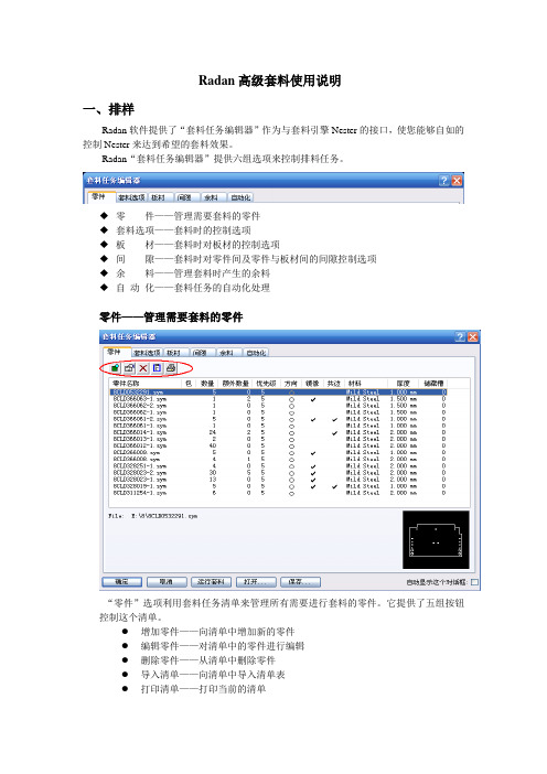
Radan高级套料使用说明一、排样Radan软件提供了“套料任务编辑器”作为与套料引擎Nester的接口,使您能够自如的控制Nester来达到希望的套料效果。
Radan“套料任务编辑器”提供六组选项来控制排料任务。
◆零件——管理需要套料的零件◆套料选项——套料时的控制选项◆板材——套料时对板材的控制选项◆间隙——套料时对零件间及零件与板材间的间隙控制选项◆余料——管理套料时产生的余料◆自动化——套料任务的自动化处理零件——管理需要套料的零件“零件”选项利用套料任务清单来管理所有需要进行套料的零件。
它提供了五组按钮控制这个清单。
●增加零件——向清单中增加新的零件●编辑零件——对清单中的零件进行编辑●删除零件——从清单中删除零件●导入清单——向清单中导入清单表●打印清单——打印当前的清单此外,可以用下方的“打开…”和“保存…”按钮来打开以前的清单及保存当前的清单。
在Radan中对“增加零件”和“编辑零件”使用同样的窗口。
这个窗口分为四个部分。
1.零件来源:在这里指定零件的来源路径及形式。
2.零件参数:在这里指定零件的参数。
○1数量:零件需要加工的数量。
这是在套料时该零件必须完成的数量。
○2额外数量:零件的额外数量。
这是该零件在清单中的所有零件的必须数量都套料完成后,在板材的剩余空间上进行该零件的套料数量。
○3储藏槽号码:用于某些有储藏槽设备的机床进行设置。
○4镜像:允许零件在套料中进行镜像套料。
○5共边切割:允许零件在套料中进行共边套料。
○6材料名称、厚度:指定零件所用的材料及厚度。
点击“改变材料…”可以对零件的材料及厚度进行修改。
3.允许方向:指定零件在套料时的方向。
4.优先级:指定零件在套料时的优先级。
优先级数值1为最高,9为最低。
套料选项——套料时的控制选项“套料选项”用于设置套料时的控制参数。
它分为五个部分。
1.输出:用于设置套料文件的名称,套料序号及套料文件保存路径。
其中套料序号在有多种套料时自动更改增加。
RAD7测量仪手册
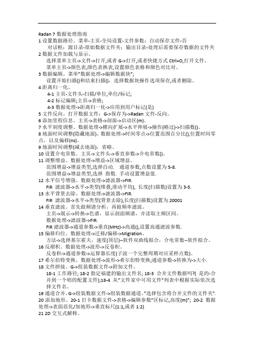
5
1.3 仪器外观 打印机 座 串行接口
接口指示灯
LCD(液晶)
电源插 RS-232 出气口
进气口 开关键
红外
图 1 RAD7 专业电子测氡仪
菜单键 确认键 左箭头键 右箭头键
1.4 设置为期 2 天的测试 将 RAD7 主机电源线,干燥剂筒(两端都有螺丝盖的大管装干燥剂),1 个
进气口过滤、一根一端带有套管而另一端带有插头的塑胶管和打印机,按图 2 所示联接。
4
第一章
1. 初识 RAD7
1.1 开箱
首先请确认所有主机和附件。开箱去除包装材料,查看箱内物品是否与所附的装箱
单上一样,如果有附件缺损,请马上与北京康高特科技有限公司联系,电话:
010-68940148。
RAD7 主机
1台
乙烯基管:3 英尺长 1 根
电源线
2根
大型干燥管
1个
背带和钥匙
1套
小型干燥管
26.8℃ RH:7% B:7.06V
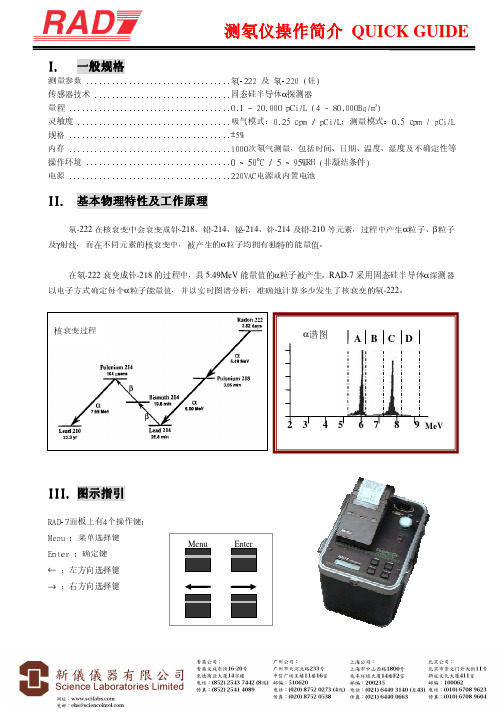
0102 中(01)为运行次数,(02)是周期数,2.69 是所测得的氡 浓度,0.73 是统计的不确定度,p 是所用的计量单位(单位为 pCi/L), Sniff 显示的是在该读数中只有 Po-218 的衰变被记录下来(三个小时 后,其模式自动转换到 Normal 模式下)。所打印的第 2 行信息清晰 地指明了日期和时间,而所打印的第 3 行则显示在测试室中的温度 和湿度,以及内部电池的电压。如果是 Medium(中)和 Long(长) 的模式下则在每个周期中会打印更多的信息。
5. 计算机连接
5.1 RS-232 串行接口 5.1.1 性能 5.1.2 所需硬件 5.1.3 所需软件 5.1.4 应用
radan7使用指南中文

美国GSSI公司RADAN7地质雷达处理软件说明书劳雷公司邓新生2013年1月1日Radan 7 guide for data processingRadan 7数据处理指南1.设置数据路径。
菜单Home->window->properties对话框properties->global parameters ->File parameters->Source Directory2.数据文件加载与显示。
选择菜单->open或者快捷方式Ctrl+O,打开文件。
菜单Home->Color tables, color Xforms,设置颜色表格和颜色对比对。
3.数据编辑。
菜单processing->adjust scans->edit block设置start scan和end scan,选择block operation选项save保存,delete删除。
4.文件反向。
菜单G->Save as->radan file reversed.删除dzx数据库文件,并重新打开翻转后的dzt数据文件。
5.距离归一化。
6.添加里程信息。
Home状态下,选择tables。
Tables->profiles->start Dist(m),输入起始里程。
Tables->profiles->Dist decrem,选择此项,桩号从大到小。
7.水平刻度调整。
Processing->adjust scans->horizontal Scaling。
8.地面调整。
9.地面时间调整。
10.设置介电常数11.调整增益。
Processing->Gain->range gain。
Range gain->gain type选择automatic. # of points设置为5.Range gain->gain type选择Exponential. 手动设置增益值.12.水平信号增强。
RAD7说明书打印文件

新仪仪器有限公司Science Laboratories Limited香港总部:香港文咸东街16至20号至德商业大厦14字楼电话:(852)25437442(8线)传真:(852)25414089 广州公司:广州市天河北路233号中信广场1116室电话:(020)87520273(3线)传真:(020)87520538RAD7氡气测量应用参考操作空气中氡气测量1、正确连接仪器。
2、PURGE五分钟:在TEST中选择PURGE,再按ENTER。
3、设置运行方案:在SETUP中选择Protocol, 再按ENTER,从中选One day测试方案后,再按ENTER。
再在SETUP中选择Recycle,设定为4次再在SETUP中选择Format,设定为Short。
4、关闭RAD7,打开打印机,开启RAD7:可打印设置情况。
5、开始测试:在TEST中选择start,再按ENTER。
土壤中氡气测量1、正确连接仪器。
2、PURGE(净化)五分钟:在TEST中选择PURGE,再按ENTER。
3、设置运行方案:在SETUP中选择Protocol(协议), 再按ENTER,从中选Sniff测试方案后,再按ENTER。
再在SETUP中选择Cycle,将时间设定为5分钟(或设定更长时间)再在SETUP中选择Recycle,设定为4次(建议只取第三、四个结果)4、关闭RAD7,打开打印机,开启RAD7:可打印设置情况。
5、开始测试:在TEST中选择start,再按ENTER。
注意:每次更换地点测量时,应先PURGE五分钟。
RAD7 操作命令列表Test(测试)Data按“Menu ”键则进入主菜单状态,或返回到主菜单状态;“ ”“ ”键则往左或往右浏览不同的命令或内容;“Enter ”键则进入子菜单目录或确认你的选择。
D U R R I D GE C O M PA N Y I N C.7 Railroad A ve., Suite D. P.O.Box 71, Bedford, MA 01730. Tel/Fax: (781)687-9556From the desk of:Derek Lane-Smith, Ph.D.Email: Derek@RAD7 电子氡气检测仪目录简介11.开始工作:您与RAD7的第一天11.1 开箱11.2 一般安全指导21.3 概貌21.4开始两天的测试31.5 开始吸气实验62.RAD7操作基本知识82.1 简介82.1.1 键盘82.1.2 命令列表92.2 测试92.2.1 测试状态92.2.1a 快速保存和重新启动112.2.2 测试开始和测试停止112.2.3 测试保存122.2.4 测试清除122.2.5 测试净化132.2.6 测试锁住132.2.7 测试睡眠132.2.8 测试打印142.2.9 测试命令142.3 数据142.3.1数据阅读142.3.2 数据打印152.3.3 数据通讯162.3.4 数据总结162.3.5 数据自由内存172.3.6数据删除172.3.7 数据重编号182.3.8 数据清除182.4 设置182.4.1 设置协议192.4.2 设置周期192.4.3 设置循环192.4.4 设置模式202.4.5 设置钍气212.4.6 设置泵体212.4.7 设置声调222.4.8 设置格式222.4.9 设置单位222.4.10 设置保存用户232.4.11 设置时钟232.4.12 设置预览232.5 特别情况232.6 红外线打印机243. RAD7技术的基本知识:工作原理26 3.1 简介263.2 氡衰变链273.2.1 氡-222(氡)293.2.2氡-220(钍)293.3 连续监测器303.4 吸气器313.5 工作浓度313.6 RAD7 固态探测器323.7 RAD7图谱323.8 窗口333.9 同位素平衡343.10 模式:吸气和自动353.11 背景、干扰和污染353.11.1 短寿命的氡和钍的继承元素363.11.2 被吸收的氡气363.11.3 内在的背景363.11.4 长寿的氡气继承元素373.11.5 产生氡气或者钍气的固体的污染37 3.11.6 其它的α粒子发射器373.11.7 β粒子和γ粒子发射器373.12精密度&正确度373.13 图谱例子383.13.1 可操作的氡气图谱383.13.2 钍气图谱403.13.3 组合图谱413.13.4 病态图谱434. 使用RAD7:良好的操作程序454.1.简介454.2.连续监测464.2.1.准备464.2.2.净化464.2.3.测试位置474.2.4.测试协议474.2.5.打印或者不打印484.2.6.运行测试484.2.7.安全性和质量控制484.2.8.完成运行494.2.9.检查数据504.2.10.非常短期监测504.3.吸气504.3.1.为什么吸气?504.3.2.定位氡气进入点504.3.3.准备514.3.4.净化514.3.5.运行测试514.3.6.钻孔取样点524.3.7.点读数524.4.抓取采样534.4.1适应性534.4.2准备534.4.3协议534.4.4接受样品534.4.5分析534.5.水里的氡气544.5.1RAD H2O544.5.2 4.5.2 RAD AQUA544.6.土壤空气采样544.6.1应用544.6.2土壤空气探针544.6.3准备554.6.4运行测试554.6.5解释数据554.7.发射测量554.7.1 应用554.7.2 开环或者闭环结构564.7.3 批量发射564.7.4 表面发射564.8.钍气测量574.8.1钍气和氡气574.8.2钍气测量问题574.8.3计算与干涉更正584.8.4避开更长寿命半衰期的衰变产物58 4.8.5衰变更正、流动速率和钍气校准58 4.8.6计算样品衰变584.8.7计算内腔浓度594.8.8内腔钍气灵敏度校准594.8.9设置钍气测量594.8.10钍气模式604.9.管理背景605. PC连接615.1 RS-232串口615.1.1 能力615.1.2 硬件桥接器615.1.3 软件桥接器615.1.4 应用615.1.5 RAD7串口的技术规格62 5.1.6 串口输出625.2 捕捉1.2645.3 传输655.4 RADLINK655.4.1能力655.4.2 要求655.4.3 RAD7远程指挥格式66 5.4.4 特别键665.4.5 特别命令676. 维修686.1 附件-使用和维护686.1.1 干燥剂686.1.1.1 实验干燥设备696.1.1.2小干燥管(小管)69 6.1.1.3 层叠式干燥管696.1.2 过滤器706.1.3 电池706.1.4 实时时钟和非易失内存71 6.1.5 打印机和适配器716.2 操作范围716.3 服务和维修726.3.1 校准726.3.2 维修726.3.3 运输736.3.4 升级736.4 RAD7规格73简介RAD7是具有非常多功能的仪器,是综合氡气测试系统的基础仪器,可以在不同的模式下操作和用于不同的目的。
雷达操作手册
操作说明书FAR-28x7系列FAR-21x7(-BB)系列海华公司内部资料目 录1. RADAR OPERATION雷达操作 (1)1.1 Turning on the Power打开电源 (1)1.2 Transmitter ON发射 (1)1.3 Control Uuit控制单元 (1)1.4 Main Menu主菜单 (1)1.5 Operation Using the On-Screen Boxes屏幕上的操作 (2)1.6 CURSOR Menu光标菜单 (3)1.7 Monitor Brilliance 屏幕亮度 (3)1.8 Choosing the Display Mode选择显示模式 (3)1.9 ON-Screen Boxes and Markers屏幕上的方框和标记 (4)1.10 Tuning the Receiver调谐接收机 (4)1.10.1 Choosing the tuning method选择调谐方式 (4)1.10.2 Initializing tuning初始化调谐 (4)1.10.3 Automatic tuning自动调谐 (5)1.10.4 Manual tuning手动调谐 (5)1.11 Aligning Heading with Gyrocompass调整船首向 (5)1.12 Presentation Modes 显示模式 (5)1.12.1 Choose presentation mode选择显示模式 (6)1.12.2 Description of presentation modes 显示模式介绍 (6)1.13 Entering Own Ship’s Speed输入本船速度 (6)1.13.1 Automatic speed input by log or GPS navigator从计程仪或GPS自动输入速度 (7)1.13.2 Manual speed input手动输入速度 (7)1.14 Choosing the Range Scale选择量程 (7)1.15 Choosing the Pulselength选择脉冲长度 (8)1.15.1 Choosing pulselength 选择脉冲长度 (8)1.15.2 Changing pulselength 改变脉冲长度 (8)1.16 Adjusting the Sensitivity 调节灵敏度 (9)1.17 Suppressing Sea Clutter 抑制海浪干扰 (9)1.17.1 Choosing method of adjustment 选择调节方法 (9)1.17.2 Automatic adjustment by the A/C SEA control调节海浪抑制 (9)1.18 Suppressing Rain Clutter 抑制雨水干扰 (9)1.18.2 Adjusting A/C RAIN调节雨水干扰 (10)1.19 Interference Rejector 干扰抑制器 (10)1.20 Measuring the Range 测量量程 (11)1.20.1 Turning range rings on/off 开/关范围圈 (11)1.20.2 Measuring range by variable range marker(VRM)利用可变距离刻度测量范围 (12)1.20.3 Choosing VRM unit of measurement(B,C and W types)选择VRM度量刻度 (13)1.21 Measuring the Bearing测量方位 (13)1.21.1 Measuring the bearing测量方位 (13)1.21.2 Choosing true or relative bearing选择真方位或相对方位 (14)1.22 Collision Assessment by Offset EBL利用电子方位线估算碰撞 (14)1.22.1 How to assess risk of collision by the offset EBL利用EBL估算碰撞危险 (15)1.23 Measuring Range and Bearing Between Two Targets测量两个目标距离和方位键盘 (15)1.24 Setting a Target Alarm设置目标报警 (16)1.24.1 How to set a target alarm zone怎样设置目标警报区域 (16)1.24.2 Acknowledging the target alarm确认目标报警 (17)1.24.3 Deactivating a target alarm解除目标报警 (17)1.24.4 Target alarm attributes目标报警属性 (17)1.25 Off-entering the Display 关闭中心显示 (18)1.26 Echo Stretch 回波放大 (19)1.27 Echo Averaging回波平均值 (19)1.28 Target Trails目标轨迹 (20)1.28.1 True or relative trails真运动或相对运动轨迹 (20)1.28.2 Trail time轨迹时间 (20)1.28.3 Trail gradation轨迹级别 (21)1.28.4 Saving, copying target trails保存,复制目标轨迹 (21)1.28.5 Trail level轨迹级别 (21)1.28.6 Narrow trails(B,C and W types)使轨迹变窄 (21)1.28.7 Longer trails(B,C and W types)使轨迹更长 (22)1.28.8 Removing trails from the display temporarily临时删除轨迹 (22)1.28.9 Erasing trails消除轨迹 (22)1.29 Parallel Index Lines并行索引线 (22)1.29.1 Displaying, erasing parallel index lines显示,消除并行索引线 (23)1.29.2 Adjusting index line orientation, index line interval调整索引线方位和间隔 (23)1.29.3 Index line bearing reference索引线方位基准 (24)1.29.4 Choosing maximum number of index lines to display选择显示最大数量索引线 (24)1.29.5 Index line mode索引线模式 (25)1.30 Origin Mark原点标记 (25)1.30.1 Entering origin marks输入;原点标记 (25)1.30.2 Origin mark stabilization原点标记稳定性 (26)1.30.3 Deleting individual origin marks删除个别原点标记 (26)1.31 Zoom放大 (26)1.32 Markers标记 (27)1.32.1 Heading marker and heading line航向标记和航向线 (27)1.32.2 Stern marker船尾标记 (28)1.32.3 North marker向北标记 (28)1.32.4 Own ship symbol本船符号 (28)1.32.5 Barge marker闯入目标标记 (28)1.33 Automatic Picture Setup According to Navigation Purpose根据航行目的自动设置雷达 (29)1.34 Programming Function Keys 设计功能键 (29)1.34.1 Activating a function key激活功能键 (30)1.34.2 Programming the function keys设置功能键 (30)1.35 Ship’s Position 本船位置 (31)1.36 Noise Rejector抑制噪声 (31)1.37 Suppressing Second-trace Echoes抑制二次回波 (32)1.38 Adjusting Brilliance of Screen Data调整屏幕亮度 (32)1.39 Watch Alarm监视报警 (32)1.40 Setting Up Nav Data设置导航数据 (33)1.41 Text Window Setup文本窗口设置 (33)1.42 Customizing Operation自定义操作 (34)1.43 Alarms报警 (35)1.44 Choosing the Antenna, Displaying Antenna Information选择天线、显示天线信息 (35)1.44.1 Choosing the antenna选择天线 (35)1.44.2 Displaying antenna information显示天线信息 (35)1.45 Cursor Data光标数据 (35)1.46 Performance Monitor性能监视器 (36)1.47 Wiper擦除器 (36)1.48 Own Ship Symbol本船记号 (36)1.49 Color and Brilliance Sets颜色和亮度设置 (36)1.49.1 Choosing color and brilliance set选择颜色和亮度设置 (37)1.49.2 Presetting color and brilliance set预设颜色和亮度 (37)1.50 Reference Point for CPA/TCPA CPA/TCPA参考点 (37)1.51 Switching Hub HUB-100(option) (37)2.RADAR OBSERVATION (38)3.ARP OPERATION ARP操作 (38)3.1 Usage Precautions使用注意点 (38)3.2 Controls for ARP ARP控制键 (38)3.3 Activating, Deactivating ARP激活,静默ARP (38)3.4Entering Own Ship's Speed输入本船速度 (39)3.4.1 Echo-referenced speed input回波基准速度 (39)3.5 Automatic Acquisition自动获取 (40)3.5.1 Enabling auto acquisition 启动自动获取 (40)3.5.1 Terminating tracking of targets(including reference targets)终止目标追踪(包括参考目标) (41)3.6 Manual Acquisition手动获取 (42)3.6.1 Setting manual acquisition conditions设置手动获取条件 (42)3.6.2 Manually acquiring a target手动获取目标 (42)3.7 ARP Symbols and ARP Symbol Attributes ARP形状及特性 (42)3.7.4 Symbols color and size形状的颜色和大小 (42)3.7.5 Auto target track(A,B,C and W types)自动目标跟踪 (43)3.8 Displaying Target Data显示目标数据 (43)3.8.1 Displaying individual target data显示个别目标数据 (43)3.8.2 Target list目标清单 (44)3.9 Vector Modes向量模式 (44)3.9.1 Description of vectors向量介绍 (44)3.10 Past Position Display历史位置显示 (45)3.10.1 Displaying and erasing past position points, choosing past position plot interval显示和消除历史位置点,选择历史位置标绘间隔 (45)3.10.2 Past position display attributes历史位置显示特性 (45)3.11 Set and Drift角度和漂移(光标位置) (46)3.12 Setting CPA/TCPA Alarm Ranges设置CPA/TCPA报警范围 (46)3.12.1 Setting CPA/TCPA alarm ranges设置CPA/TCPA报警范围 (47)3.12.2 Acknowledging CPA/TCPA alarm应答报警 (47)3.13 Setting a Guard Zone设置警戒区 (47)3.13.1 Activating the guard zone激活警戒区 (47)3.13.2 Sleeping, deactivating a guard zone静默,撤消警戒区 (48)3.13.3 Acknowledging the guard zone alarm应答警戒区报警 (49)3.13.4 Guard zone reference警戒区基准 (49)3.13.5 Guard zone shape and stabilization警戒区形状和稳定性 (49)3.14 Operational Warnings操作警告 (49)3.15 Trial Maneuver (50)3.16 ARP Performance Test ARP性能测试 (50)3.17Criteria for Selecting Targets for Tracking选择跟踪目标的原则 (50)3.18 Factors Affecting ARP Functions影响ARP功能的因素 (51)1. RADAR OPERATION雷达操作1.1 Turning on the Power打开电源打开[POWER]开关,屏幕显示计数时间,当计数器到达0:00时,就会显示”ST-BY”,表示雷达已经准备好发射.1.2 Transmitter ON发射打开电源开关,等待至屏幕出现“ST--BY”字样,才可以按[STBY/TX]键发射;关机时应先停止发射,即先按[STBY/TX]键停止发射,然后才可以关闭电源。
氡测试仪RAD7-操作说明书
Menu
Enter
1
测氡仪操作简介 QUICK GUIDE
IV. 菜单选择
主菜单分别为 TEST﹝测试﹞→DATA﹝数据﹞→SETUP﹝设置﹞→SPECIAL﹝特别﹞
子菜单包括 TEST
灵敏度 吸气模式: ;测量模式: ....................................
0.25 cpm / pCi/L
0.5 cpm / pCi/L
规格 ......................................±5%
内存 ......................................1000次氡气测量,包括时间、日期、温度、湿度及不确定性等
DATA – 2. Print﹝打印﹞:输入打印数据的序号 DATA – 3. Com﹝通讯﹞:将数据转移到计算器上的 RS-232 串口 DATA – 4. Summary﹝总结﹞输入总结的序号 DATA – 5. Free﹝剩余内存﹞:显示余下的内存容量 DATA – 6. Delete﹝删除﹞:输入删除的序号 DATA – 7. Renumber﹝重编号﹞:把已删除的序号重新编排 DATA – 8. Erase﹝清除﹞:完全消除所有数据
主菜单 SPECIAL﹝特别﹞模式 SPECIAL﹝特别﹞模式于安装 RADLINK 后才能够使用,请参阅操作手册
V. 基本操作及使用
1. 把干燥剂及过滤器等配件与 RAD-7 接上。 2. 启动 RAD-7,进入主菜单 SETUP﹝设置﹞中的 Protocol﹝协议﹞内,选择合适的预设协议,或是在 SETUP
Radan 7数据处理指南
Radan 7数据处理指南1设置数据路径。
菜单-主页-全局设置-文件参数;自动保存文件-否对话框:源目录-原始数据文件夹;输出目录-处理后需要保存数据的文件夹2数据文件加载与显示。
选择菜单主页->文件->打开,或者G->打开,或者快捷方式Ctrl+O,打开文件。
菜单主页->颜色表,颜色表换表,设置颜色表格和颜色对比对。
3数据编辑。
菜单”数据处理->编辑数据块”;设置开始扫描()和结束扫描(),选择数据块操作选项保存,或者删除。
4距离归一化。
4-1主页-文件头-扫描/单位,单位/标记;4-2标记编辑;主页->表格;4-3数据处理->距离归一化->应用到用户标记(是)5文件反向。
打开数据文件;G->保存为->Radan文件-反向。
6添加里程信息。
主页->表格->剖面->启动区(m)。
7水平刻度调整。
数据处理->横向扩展->水平伸展->操作(略过)->扫描数()。
8地面时间调整(隐藏地面)。
数据处理->时间零点->位置范围百分比(),位置时间零点,以及偏移(ns)。
9地面时间调整(减去地面),省略。
10设置介电常数。
主页->文件头->垂直参数->介电常数()。
11调整增益。
数据处理->增益->区域增益。
范围增益->增益类型,选择自动. 通道参数,点数设置为5-8.范围增益->增益类型,选择指数. 手动设置增益值.12水平信号增强。
数据处理->滤波器->FIR.FIR 滤波器->水平->类型(堆叠,滑动平均), 长度(扫描数)设置为3-5.13水平背景去除。
数据处理->滤波器->FIR.FIR 滤波器->水平->类型(背景去除),长度(扫描数)设置为2000114垂直滤波。
首先做频谱分析,再做频率滤波。
radan7使用指南中英文
Radan 7 guide for data processingRadan 7数据处理指南1.设置数据路径。
菜单Home->window->properties对话框properties->global parameters ->>Source Directory2.数据文件加载与显示。
选择菜单->open或者快捷方式Ctrl+O,打开文件。
菜单Home->Color tables, color Xforms,设置颜色表格和颜色对比对。
3.数据编辑。
菜单processing->adjust scans->edit block设置start scan和end scan,选择block operation选项save保存,delete删除。
4.文件反向。
菜单G->Save as->radan .删除dzx数据库文件,并重新打开翻转后的dzt数据文件。
5.距离归一化。
6.添加里程信息。
Home状态下,选择tables。
Tables->profiles->start Dist(m),输入起始里程。
Tables->profiles->Dist decrem,选择此项,桩号从大到小。
7.水平刻度调整。
Processing->adjust scans->horizontal Scaling。
8.地面调整。
9.地面时间调整。
10.设置介电常数11.调整增益。
Processing->Gain->range gain。
Range gain->gain type选择automatic. # of points设置为5.Range gain->gain type选择Exponential. 手动设置增益值.12.水平信号增强。
Processing->filters->FIR.FIR Filters->horizontal->type选择stacking, Length(scans)设置为3,或者5. 13.水平背景去除。
Red Hat Enterprise Linux (RHEL) 7.7 驱动用户手册说明书

Red Hat Enterprise Linux (RHEL) 7.7 DriverUser ManualRHEL 7.7NOTE:THIS HARDWARE, SOFTWARE OR TEST SUITE PRODUCT (“PRODUCT(S)”) AND ITS RELATED DOCUMENTATION ARE PROVIDED BY MELLANOX TECHNOLOGIES “AS-IS” WITH ALL FAULTS OF ANY KIND AND SOLELY FOR THE PURPOSE OF AIDING THE CUSTOMER IN TESTING APPLICATIONS THAT USE THE PRODUCTS IN DESIGNATED SOLUTIONS. THE CUSTOMER'S MANUFACTURING TEST ENVIRONMENT HAS NOT MET THE STANDARDS SET BY MELLANOX TECHNOLOGIES TO FULLY QUALIFY THE PRODUCT(S) AND/OR THE SYSTEM USING IT. THEREFORE, MELLANOX TECHNOLOGIES CANNOT AND DOES NOT GUARANTEE OR WARRANT THAT THE PRODUCTS WILL OPERATE WITH THE HIGHEST QUALITY. ANY EXPRESS OR IMPLIED WARRANTIES, INCLUDING, BUT NOT LIMITED TO, THE IMPLIED WARRANTIES OF MERCHANTABILITY, FITNESS FOR A PARTICULAR PURPOSE AND NONINFRINGEMENT ARE DISCLAIMED. IN NO EVENT SHALL MELLANOX BE LIABLE TO CUSTOMER OR ANY THIRD PARTIES FOR ANY DIRECT, INDIRECT, SPECIAL, EXEMPLARY, OR CONSEQUENTIAL DAMAGES OF ANY KIND (INCLUDING, BUT NOT LIMITED TO, PAYMENT FOR PROCUREMENT OF SUBSTITUTE GOODS OR SERVICES; LOSS OF USE, DATA, OR PROFITS; OR BUSINESS INTERRUPTION) HOWEVER CAUSED AND ON ANY THEORY OF LIABILITY, WHETHER IN CONTRACT, STRICT LIABILITY, OR TORT (INCLUDING NEGLIGENCE OR OTHERWISE) ARISING IN ANY WAY FROM THE USE OF THE PRODUCT(S) AND RELATED DOCUMENTATION EVEN IF ADVISED OF THE POSSIBILITY OF SUCH DAMAGE.Mellanox Technologies350 Oakmead Parkway Suite 100Sunnyvale, CA 94085U.S.A.Tel: (408) 970-3400Fax: (408) 970-3403© Copyright 2019. Mellanox Technologies Ltd. All Rights Reserved.Mellanox®, Mellanox logo, Mellanox Open Ethernet®, LinkX®, Mellanox Spectrum®, Mellanox Virtual Modular Switch®, MetroDX®, MetroX®, MLNX-OS®, ONE SWITCH. A WORLD OF OPTIONS®, Open Ethernet logo, Spectrum logo, Switch-IB®, SwitchX®, UFM®, and Virtual Protocol Interconnect® are registered trademarks of Mellanox Technologies, Ltd.For the complete and most updated list of Mellanox trademarks, visit /page/trademarks.All other trademarks are property of their respective owners.Table of ContentsDocument Revision History (5)1Firmware Burning (6)2Port Type Management (7)3Modules Loading and Unloading (8)4Important Packages and Their Installation (9)5SR-IOV Configuration (10)5.1Setting up SR-IOV (10)6Default RoCE Mode Setting (12)7PXE over InfiniBand Installation (13)List of TablesTable 1: Document Revision History (5)Document Revision HistoryTable 1: Document Revision HistoryRevision Date DescriptionRHEL 7.7 October 22, 2019 Initial version of this document.1 Firmware Burning1.Check the device’s PCI address.lspci | grep MellanoxExample:00:06.0 Infiniband controller: Mellanox Technologies MT27520 Family[ConnectX-3 Pro]2.Identify the adapter card's PSID.# mstflint -d 81:00.0 qImage type: FS2FW Version: 2.42.5000FW Release Date: 26.7.2017Rom Info: type=PXE version=3.4.752 devid=4103Device ID: 4103Description: Node Port1 Port2Sys imageGUIDs: e41d2d0300b3f590 e41d2d0300b3f591 e41d2d0300b3f592e41d2d0300b3f593MACs: e41d2db3f591 e41d2db3f592VSD:PSID: MT_10901110193.Download the firmware BIN file from the Mellanox website that matches your card'sPSID.4.Burn the firmware.# mstflint -d <lspci-device-id> -i <image-file> b5.Reboot your machine after the firmware burning is completed.2 Port Type ManagementConnectX®-3 onwards adapter cards’ ports can be individually configured to work asInfiniBand or Ethernet ports. By default, ConnectX® family adapter cards VPI ports areinitialized as InfiniBand ports. If you wish to change the port type use the mstconfig afterthe driver is loaded.1.Install mstflint tools.yum install mstflint2.Check the device’s PCI address.lspci | grep MellanoxExample:00:06.0 Infiniband controller: Mellanox Technologies MT27520 Family[ConnectX-3 Pro]e mstconfig to change the link type as desired IB – for InfiniBand, ETH – for Ethernet.mstconfig –d <device pci> s LINK_TYPE_P1/2=<ETH|IB|VPI>Example:# mstconfig -d 00:06.0 s LINK_TYPE_P1=ETHDevice #1:----------Device type: ConnectX3ProPCI device: 00:06.0Configurations: Current NewLINK_TYPE_P1 IB(1) ETH(2)Apply new Configuration? ? (y/n) [n] : yApplying... Done!-I- Please reboot machine to load new configurations.4.Reboot your machine.3 Modules Loading and UnloadingMellanox modules for ConnectX®-2/ConnectX®-3/ConnectX®-3 Pro are:•mlx4_en, mlx4_core, mlx4_ibMellanox modules for ConnectX®-4/ConnectX®-4 Lx/ ConnectX®-5/ ConnectX®-5Ex/ConnectX-6 are:•mlx5_core, mlx5_ibIn order to unload the driver, you need to first unload mlx*_en/ mlx*_ib and then themlx*_core module.To load and unload the modules, use the commands below:•Loading the driver: modprobe <module name># modprobe mlx5_ib•Unloading the driver: modprobe –r <module name># modprobe –r mlx5_ib4 Important Packages and Their Installationrdma-corerdma-core RDMA core userspace libraries and daemonslibibmad: Low layer InfiniBand diagnostic and management programslibibmad OpenFabrics Alliance InfiniBand MAD libraryopensm: InfiniBand Subnet Manageropensm-libs Libraries used by OpenSM and included utilitiesopensm OpenIB InfiniBand Subnet Manager and management utilitiesIbutils: OpenIB Mellanox InfiniBand Diagnostic Toolsibutils-libs Shared libraries used by ibutils binariesibutils OpenIB Mellanox InfiniBand Diagnostic Toolsinfiniband-diags: OpenFabrics Alliance InfiniBand Diagnostic Toolsinfiniband-diags OpenFabrics Alliance InfiniBand Diagnostic Toolsperftest: IB Performance testsperftest IB Performance Testsmstflint: Mellanox Firmware Burning and Diagnostics Toolsmstflint Mellanox firmware burning toolTo install the packages above run:# yum install libibverbs librdmacm libibcm libibmad libibumad libmlx4libmlx5 opensm ibutils infiniband-diags srptools perftest mstflint rdmacm-utils ibverbs-utils librdmacm-utils -y5 SR-IOV Configuration5.1 Setting up SR-IOV1.Install the mstflint tools.# yum install mstflint2.Check the device’s PCI.# lspci | grep MellanoxExample:00:06.0 Infiniband controller: Mellanox Technologies MT27520 Family[ConnectX-3 Pro]3.Check if SR-IOV is enabled in the firmware.mstconfig -d <device pci> qExample:# mstconfig -d 00:06.0 qDevice #1:----------Device type: ConnectX3ProPCI device: 00:06.0Configurations: CurrentSRIOV_EN True(1)NUM_OF_VFS 8LINK_TYPE_P1 ETH(2)LINK_TYPE_P2 IB(1)LOG_BAR_SIZE 3BOOT_PKEY_P1 0BOOT_PKEY_P2 0BOOT_OPTION_ROM_EN_P1 True(1)BOOT_VLAN_EN_P1 False(0)BOOT_RETRY_CNT_P1 0LEGACY_BOOT_PROTOCOL_P1 PXE(1)BOOT_VLAN_P1 1BOOT_OPTION_ROM_EN_P2 True(1)BOOT_VLAN_EN_P2 False(0)BOOT_RETRY_CNT_P2 0LEGACY_BOOT_PROTOCOL_P2 PXE(1)BOOT_VLAN_P2 1IP_VER_P1 IPv4(0)IP_VER_P2 IPv4(04.Enable SR-IOV:mstconfig –d <device pci> s SRIOV_EN=<False|True>5.Configure the needed number of VFsmstconfig –d <device pci> s NUM_OF_VFS=<NUM>NOTE: This file will be generated only if IOMMU is set in the grub.conf file (byadding “intel_iommu=on” to /boot/grub/grub.conf file).6.[mlx4 devices only] Create/Edit the file /etc/modprobe.d/mlx4.conf:options mlx4_core num_vfs=[needed num of VFs] port_type_array=[1/2 for IB/ETH],[ 1/2 for IB/ETH]Example:options mlx4_core num_vfs=8 port_type_array=1,17.[mlx5 devices only] Write to the sysfs file the number of needed VFs.echo [num_vfs] > sys/class/net/ib2/device/sriov_numvfsExample:# echo 8 > /sys/class/net/ib2/device/sriov_numvfs8.Reboot the driver.9.Load the driver and verify that the VFs were created.# lspci | grep mellanoxExample:00:06.0 Network controller: Mellanox Technologies MT27520 Family[ConnectX-3 Pro]00:06.1 Network controller: Mellanox Technologies MT27500/MT27520 Family [ConnectX-3/ConnectX-3 Pro Virtual Function]00:06.2 Network controller: Mellanox Technologies MT27500/MT27520 Family [ConnectX-3/ConnectX-3 Pro Virtual Function]00:06.3 Network controller: Mellanox Technologies MT27500/MT27520 Family [ConnectX-3/ConnectX-3 Pro Virtual Function]00:06.4 Network controller: Mellanox Technologies MT27500/MT27520 Family [ConnectX-3/ConnectX-3 Pro Virtual Function]00:06.5 Network controller: Mellanox Technologies MT27500/MT27520 Family [ConnectX-3/ConnectX-3 Pro Virtual Function]00:06.6 Network controller: Mellanox Technologies MT27500/MT27520 Family [ConnectX-3/ConnectX-3 Pro Virtual Function]00:06.7 Network controller: Mellanox Technologies MT27500/MT27520 Family [ConnectX-3/ConnectX-3 Pro Virtual Function]00:06.0 Network controller: Mellanox Technologies MT27500/MT27520 Family [ConnectX-3/ConnectX-3 Pro Virtual Function]For further information, refer to section Setting Up SR-IOV MLNX_OFED User Manual.6 Default RoCE Mode Setting1.Mount the configfs file.# mount -t configfs none /sys/kernel/config2.Create a directory for the mlx4/mlx5 device.# mkdir -p /sys/kernel/config/rdma_cm/mlx4_0/3.Validate what is the used RoCE mode in the default_roce_mode configfs file.# cat /sys/kernel/config/rdma_cm/mlx4_0/ports/1/default_roce_modeIB/RoCE v14.Change the default RoCE mode,•For RoCE v1: IB/RoCE v1•For RoCE v2: RoCE v2# echo "RoCE v2" >/sys/kernel/config/rdma_cm/mlx4_0/ports/1/default_roce_mode# cat /sys/kernel/config/rdma_cm/mlx4_0/ports/1/default_roce_modeRoCE v2# echo "IB/RoCE v1" >/sys/kernel/config/rdma_cm/mlx4_0/ports/1/default_roce_mode# cat /sys/kernel/config/rdma_cm/mlx4_0/ports/1/default_roce_modeIB/RoCE v17 PXE over InfiniBand InstallationPXE over InfiniBand infrastructure has additional parameter in the Boot Loader file forloading the necessary modules and interfaces and for allowing sufficient time to get the link.To install RHEL from PXE using the IPoIB interfaces, add the following parameters to theBoot Loader file, located in the var/lib/tftpboot/pxelinux.cfg directory, at thePXE server:bootdev=ib0 ksdevice=ib0 net.ifnames=0 biosdevname=0 rd.neednet=1rd.bootif=0 rd.driver.pre=mlx5_ib,mlx4_ib,ib_ipoib ip=ib0:dhcp.dhcp.retry=10 .timeout.iflink=60 .timeout.ifup=80.timeout.carrier=80Example:default RH7.5prompt 1timeout 600label RH7.5kernelappend bootdev=ib0 ksdevice=ib0 net.ifnames=0 biosdevname=0 rd.neednet=1rd.bootif=0 rd.driver.pre=mlx5_ib,mlx4_ib,ib_ipoib ip=ib0:dhcp.dhcp.retry=10 .timeout.iflink=60 .timeout.ifup=80.timeout.carrier=80。
radan7使用指南中文要点

7
邓新生 2012 年 4 月 12 日版本
COLOR TABLE选S择菜单 COLOR XTROM选S 择菜单
8
邓新生 2012 年 4 月 12 日版本
标记类型显示为 Long。 选择菜单 Radan 7-> Home-> Properties-> Global Parameters-> View Attributes->
5. 距离归一化。 6. 添加里程信息。 Home 状态下,选择 tables。
Tables->profiles->start Dist(m,) 输入起始里程。 Tables->profiles->Dist decrem,选择此项,桩号从大到小。 7. 水平刻度调整。 Processing->adjust scans->horizontal Scalin。g 8. 地面调整。 9. 地面时间调整。 10. 设置介电常数 11. 调整增益。 Processing->Gain->range ga。in Range gain->gain type选择 automatic. # of points 设置为 5. Range gain->gain type选择 Exponential. 手动设置增益值 . 12. 水平信号增强。 Processing->filters->FIR. FIR Filters->horizontal->type选择 stacking, Length(scans设) 置为 3,或者 5. 13. 水平背景去除。 Processing->Filters->FIR. FIR Filters->horizontal->type选择 BKGR REMOVAL, Length(sca设ns置) 为 1023. 14. 垂直滤波。首先做频谱分析,再做频率滤波。 Home->Display->Transfer->spectrum,显示剖面频谱。 Processing->Filters->FIR. FIR Filters->Vertical(MHz)->High Pas设s,置高通滤波参数 . 15. 偏移归位。 Processing->Focus->Migratio。n Method 选择 Kirchhoff,Velocity(Top Layer自) 己调整,软件自动给出 Dieletric。 16. 反褶积 Processing->Waveform->Deconvolution。 Deconvolution->Channel Parameters->Operator Length算子长度,采样点数。 17. 希尔伯特变换。 Processing->Waveform->Hibert Xform. 18. 文件拼接。 G->Assemble->Append File。s Merge file databases? 选择 ”Yes–Merge into one long profile”合成一个大剖面。 19. 通道合并。 G->Assemble->combine Channel。s 20. 界面划分。
RAD7测氡仪的操作规程
RAD-7测氡仪操作规程一、仪器工作原理及性能:RAD-7测氡仪是利用α能谱测定法的原理,来对空气中的氡含量进行测定的仪器,可对氡进行全面测量,能在多种模式下工作以完成不同测试目的。
二、仪器操作:1. 开机前的准备使用前电池应充足电,干燥筒中应有足量的干燥剂,将RAD-7与各部件连接好,准备开机。
2. 正常操作步骤2.1打开RAD-7电源,按下“meau”键,再按“Enter”进入“Test”选项,用方向键选择“Test Purge”(测试净化),按“Enter”键进入,气泵工作,开始净化,让仪器净化5分钟以上,净化好后,按“meau”键,停止净化。
2.2设置运行方案2.2.1在“Setup”选项中选择“Protocol”(预置协议),按“Enter”确认后,从中选择测试方案One day,再按“Enter”确认。
2.2.2在“Setup”中选择“Cycle”(周期时间),设定所需周期时间,可设为30min。
2.2.3在“Setup”中选择“Recycle”(循环次数),按需要设定次数,可设为4次。
2.2.4在“Setup”中选择“mode”(模式),选择所需模式,可以选择Auto(自动)。
2.2.5在“Setup”中选择“Thoron”(钍气),选择“off”(关)。
2.2.6在“Setup”中选择“Pump”(泵体),选择泵工作模式,可以选择Auto(自动)。
2.2.7在“Setup”中选择“Format”(格式),选择打印格式(有短、中、长、关四种格式)。
选择short(短),则打印出来的第一行第二个数据就是氡浓度。
2.2.8关闭RAD-7,打开打印机,开启RAD-7即可打印设置情况,如无需打印,可略过这步3. 开始测试3.1在“Test”中选择“Start”(开始),按“Enter”确认,仪器开始工作,测量完成后,测量数据将自动被存储,如连接打印机,将自动打印在打印纸上。
3.2将一次运转的数据的总结报告和时间图表打印出来,Data(选择)>Summary(数据总结),并输入二位数的运行序号,就可以打印出信息。
radan7使用指南中文

美国GSSI公司RADAN7地质雷达处理软件说明书劳雷公司邓新生2013年1月1日Radan 7 guide for data processingRadan 7数据处理指南1.设置数据路径。
菜单Home->window->properties对话框properties->global parameters ->File parameters->Source Directory2.数据文件加载与显示。
选择菜单->open或者快捷方式Ctrl+O,打开文件。
菜单Home->Color tables, color Xforms,设置颜色表格和颜色对比对。
3.数据编辑。
菜单processing->adjust scans->edit block设置start scan和end scan,选择block operation选项save保存,delete删除。
4.文件反向。
菜单G->Save as->radan file reversed.删除dzx数据库文件,并重新打开翻转后的dzt数据文件。
5.距离归一化。
6.添加里程信息。
Home状态下,选择tables。
Tables->profiles->start Dist(m),输入起始里程。
Tables->profiles->Dist decrem,选择此项,桩号从大到小。
7.水平刻度调整。
Processing->adjust scans->horizontal Scaling。
8.地面调整。
9.地面时间调整。
10.设置介电常数11.调整增益。
Processing->Gain->range gain。
Range gain->gain type选择automatic. # of points设置为5.Range gain->gain type选择Exponential. 手动设置增益值.12.水平信号增强。
- 1、下载文档前请自行甄别文档内容的完整性,平台不提供额外的编辑、内容补充、找答案等附加服务。
- 2、"仅部分预览"的文档,不可在线预览部分如存在完整性等问题,可反馈申请退款(可完整预览的文档不适用该条件!)。
- 3、如文档侵犯您的权益,请联系客服反馈,我们会尽快为您处理(人工客服工作时间:9:00-18:30)。
Radan 7 guide for data processingRadan 7数据处理指南1.设置数据路径。
菜单Home->window->properties对话框properties->global parameters ->File parameters->Source Directory2.数据文件加载与显示。
选择菜单->open或者快捷方式Ctrl+O,打开文件。
菜单Home->Color tables, color Xforms,设置颜色表格和颜色对比对。
3.数据编辑。
菜单processing->adjust scans->edit block设置start scan和end scan,选择block operation选项save保存,delete删除。
4.文件反向。
菜单G->Save as->radan file reversed.删除dzx数据库文件,并重新打开翻转后的dzt数据文件。
5.距离归一化。
6.添加里程信息。
Home状态下,选择tables。
Tables->profiles->start Dist(m),输入起始里程。
Tables->profiles->Dist decrem,选择此项,桩号从大到小。
7.水平刻度调整。
Processing->adjust scans->horizontal Scaling。
8.地面调整。
9.地面时间调整。
10.设置介电常数11.调整增益。
Processing->Gain->range gain。
Range gain->gain type选择automatic. # of points设置为5.Range gain->gain type选择Exponential. 手动设置增益值.12.水平信号增强。
Processing->filters->FIR.FIR Filters->horizontal->type选择stacking, Length(scans)设置为3,或者5. 13.水平背景去除。
Processing->Filters->FIR.FIR Filters->horizontal->type选择BKGR REMOVAL, Length(scans)设置为1023. 14.垂直滤波。
首先做频谱分析,再做频率滤波。
Home->Display->Transfer->spectrum,显示剖面频谱。
Processing->Filters->FIR.FIR Filters->Vertical(MHz)->High Pass,设置高通滤波参数.15.偏移归位。
Processing->Focus->Migration。
Method选择Kirchhoff,Velocity(Top Layer)自己调整,软件自动给出Dieletric。
16.反褶积Processing->Waveform->Deconvolution。
Deconvolution->Channel Parameters->Operator Length算子长度,采样点数。
17.希尔伯特变换。
Processing->Waveform->Hibert Xform.18.文件拼接。
G->Assemble->Append Files。
Merge file databases? 选择”Yes – Merge into one long profile”合成一个大剖面。
19.通道合并。
G->Assemble->combine Channels。
20.界面划分。
Radan 7 guide for data processing Radan 7数据处理指南0选择桌面快捷方式软件注册软件自动升级1.设置数据路径。
菜单”主菜单->窗口->属性Home->window->properties”仅打开RADAN7软件而不打开任何数据文件,可以调整全局参数global Parameters,对话框”属性->全局参数->文件参数->源文件夹properties->global parameters ->File parameters->Source Directory”。
选择RADAN7软件默认路径手动指定RADAN7软件工作路径2.数据文件加载与显示。
选择菜单G->open或者快捷方式Ctrl+O,打开文件。
菜单”主菜单->颜色表,变换表Home->Color tables, color Xforms”,设置颜色表格和颜色对比对。
地质雷达数据文件DZT打开对话框COLOR TABLES选择菜单COLOR XTROMS选择菜单标记类型显示为Long。
选择菜单Radan 7-> Home-> Properties-> Global Parameters-> View Attributes-> Marker Style -> Long波形加变面积参数Wiggle Parameters设置其中Fill填充一般选择Postive正波,填充多少选择Fill Level,设置为100。
Scale和space,单位均为像素,scale表示单个波形显示像素宽度,space表示2个波形之间的间隔。
波形加变面积显示图3.数据编辑。
菜单”处理->调整扫描->编辑块processing->adjust scans->edit block ”。
设置开始扫描start scan和结束扫描end scan,选择块操作block operation选项save 保存,delete删除。
保存数据保存数据[end scan设置为超级大的数字以保存整个地质雷达剖面]剪切数据4.文件反向。
菜单”主菜单->另存为->雷达文件反向G->Save as->radan file reversed”. 删除dzx数据库文件,并重新打开翻转后的dzt数据文件。
测线反向上图原始剖面下图方向反转后剖面5.距离归一化。
5-A 设置水平方向参数选择home->window->properties->Header,标记间隔units/mark,和测点多少scans/unit。
5-A水平参数设置注意事项:Properties->Horizontal Parameters->units/mark标记间隔参数如果为0,则在距离归一化运算Processing->时提示错误信息。
错误提示解决方法:编辑/输入文件头参数并且保存一个新文件。
输入相应的参数scans/unit和units/mark,并且选择G->Save As->Radan file,如file001marker.dzt。
打开file001marker.dzt就可以进行操作。
5-B标记管理在野外现场采集数据时,直接在现场做标记;比如每5米一个记号、整50米做双标记以帮助判断里程桩号。
若现场有些标记未及时打上去,可以利用radan 7软件进行添加;多打的标记利用radan7删除。
直接在表格table中选择用户标记user mark复选框,可添加标记;取消复选框可删除标记。
原始参数5-B 添加标记对话框5-C添加距离。
选择菜单”处理->调整扫描-> 距离归一化Processes->Adjust Scans->Distance Normalization”;在距离归一化对话框中选择”应用至用户标记Apply to user Marks”为True真实;选择ok确定进行距离归一化。
5-C 距离归一化参数距离归一化比对图[上图:结果,下图:原始数据]6.添加里程信息。
Home状态下,选择tables。
Tables->profiles->start Dist(m),输入起始里程。
·16·17Tables->profiles->Dist decrem,选择此项,桩号从大到小。
·18·19邓新生201年4月12日版本7.水平刻度调整。
Processing->adjust scans-> horizontal Scaling 。
8.地面时间调整。
8-A 地面时间调整根据900兆天线子波信号与地表反射雷达剖面图8-B.Position原始参数Properties->Header->Channel Information->position(ns)。
原始参数8-C.position信号位置重新设置为0.选择对话框“信号位置修正Position Correction”->Channel Parameters->% of Range[所占记录长度的百分比]参数设置为0.置0[% of range设置0]8-D设置地面信号选择参数Position Correction->Channel Parameters->Shift(ns)。
设置shift(ns)8-E 地质雷达剖面图置0后的地质雷达探测图像地面显示调整。
9-A.地面信息参数Properties->Channel Information->Position(ns)。
在地质雷达原始数据中Position参数一般为0.若已经利用地质雷达软件对数据进行了地面时间置0处理,则Position参数并不为0.Position参数对话框9-B. 显示地面信息。
已经利用其它地质雷达软件设置了地面时间参数信息。
利用RADAN7设置Properties->Display Parameters->Data Attributes->Use Surface。
9-C 从表面显示地质雷达探测图像显示地表以下信息[use surface: YES]9.设置介电常数,显示地质雷达深度剖面。
Properties->Vertical Parameters->Dielectric Constant。
时间剖面深度剖面t=t目标-t地面=t目标- 0=t目标10.调整增益。
Processing->Gain->range gain 。
11-A 自动增益Processing->Gain->Range gain->gain type选择automatic. # of points设置为5.增益处理菜单和对话框邓新生 201年4月12日版本·28左图:原始数据 右图:增益处理后的数据11-B 指数增益Range gain->gain type选择Exponential. 手动设置增益值.调整某一时间短内信号幅度大小,如10-20ns之间。