滨水区toronto
加拿大多伦多中央滨水区
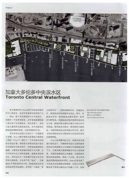
利位 置 ,最终 为人 们带 来城 市 与滨 水区 域
为 了塑造滨水 区沿岸公菸空 间的美 Nhomakorabea连 3东部湖湾 区的滨水空间新关系
条 lm宽 ,水平位置 略低 的术栈道 。花岗岩马 O
续 性 ,简洁的 波浪形 木结 构成为 在7 内 处 港
东部 湖湾区蚀一 无二的地理 位置 ,在 于 赛克 散步道 梧着现有 的 头岸壁 延伸 , 种 码 并
I 作品
07 6
卧 跏
皇后码头大道 的改造—— 以构建私 人汽车 、 公共交通工具 、行人和 骑自行车 者之间的韵 平衡 ,新东部 湖湾 区街景首批改 造项 目,希 波浪码头公共空 间的建造。
1 木质波 浪码头
在一 系列 的木 质结 构 中.士 巴丹 拿码 头 、辛高码 头和里斯 波浪码头首 次探索如何 巧妙衔接 皇后码头 大道和与之平 行的安大 略 湖之间 的水平高度 变化。设计师 受加拿大 那 蜿蜒多姿 的湖滨线 的启发 ,在城 市与湖泊 相
容, 使得每个波浪结构都各有特色。
伦 多的湖滨犬 社区的保 赶。东部 湖湾区带 来 以收集和过滤流经街区的暴雨水。
了实现城市与 滨水 区的积极有效 连接的 良好
2皇 后码 头大道
机 会。水缘 的公共空 间则是确 定这一连接 关
目 位置: 拿太多伦多 加 建 设单位: 多伦多 滨水发展公司 设 计与施工时间 2 0 。6 年至夸 珥目 规摸: . , 3 k 长 s, a 施 工造价:I 1 加元 " 9L 2
条车道( 一个方向两条车道) 使其 变成一条双 , 线性水缘 ,初级滨 水慝的公其领 域 目前 已经 向2 车道 的机动车道 ( 一个方向一 条车道) 宽 , 建成 ,为本 地居 民和 游客带来 了一处清 晰 、
多伦多中央滨水地区设计
多伦多中央滨水地区设计第一篇:多伦多中央滨水地区设计多伦多中央滨水地区设计滨水地区(包括滨河、滨湖、滨江及滨海)是一种非常有限的资源,它有助于体现每一个地区独特的历史与个性。
在过去的40年中,一度衰败的城市滨水地区的重建和开发活动使其发生了深刻的变化,这种现象已经在全球的城市中呈现一种加速的趋势。
例如,美国有75个大城市,其中69个在滨水的地理位置上,这69个城市在过去的几十年中都有对滨水地区的重建和开发活动。
90年代以来,滨水地区开发越来越成为我国城市建设中的一个热点。
随着城市经济基础逐渐雄厚,政府有财力将滨水地区的开发改造提上日程,这不仅是由于滨水地区作为城市的黄金地带,能提供土地开发和就业的新机会,而且能够提升和重塑城市形象。
随着滨水地区开发改造越来越盛行,以至于有人希望能够找到快速解决的办法,即能采用一些普遍通用的规则运用于各个地方。
例如,上世纪80年代流行一时的“节日广场”和上世纪90年代出现的“城市休闲区”。
世界各地滨水地区雷同化现象的出现是一种极大的悲哀,因为,滨水地区毕竟是一个区分于其他地区的重要因素。
而且,成功的滨水地区开发必须依赖周密而富有特色的规划设计。
因此,本文将通过2002年加拿大多伦多中央滨水地区规划设计实例的介绍,来说明如何营造个性化的滨水空间,供日益盛行的滨水地区开发活动参考。
多伦多城市滨水地区概况多伦多座落在安大略湖(Lake Ontario)的西北面,是加拿大最大的城市和金融中心。
多伦多的城区分布在安大略湖的沿岸,由于城市的不断发展,城区范围逐步从安大略湖的西北面扩大到湖的西面。
在90年代,多伦多在居住和工作环境两个方面都被列为世界十佳城市之一。
多伦多的湖滨地区由于高楼林立而成为世界上最具有都市风格的滨水地区。
1972年,多伦多制订了一个滨水地区的发展战略规划,包括湖滨地区开发的内容、时序和经济可行性。
因此,多伦多市政府兴建了多个大型的公共建筑。
以多功能开发方式来适应城市综合发展的需要,从80年代中期开始,私人开发资金进入滨水地区的一系列开发项目,主要建造高层住宅和商业办公楼,并已建成住宅1200套,商业办公楼25万平方米。
城市滨水区规划设计及开发探析——以加拿大多伦多城市滨水区为例
城市滨水区规划设计及开发探析——以加拿大多伦多城市滨水区为例近年来,随着城市化进程的不断加速,城市滨水区的规划设计和开发成为城市发展的热点话题。
城市滨水区是指城市河流、湖泊或海岸线等水域旁的地区,是城市的重要组成部分,拥有丰富的自然资源和人文价值。
本文将以加拿大多伦多城市滨水区为例,探讨其规划设计和开发经验。
首先,加拿大多伦多的滨水区规划注重生态保护和可持续发展。
多伦多市政府通过建立生态保护区、湿地恢复和水质监测等措施,保护滨水区的生态环境,确保其生物多样性和可持续性发展。
例如,多伦多湖滨区的湖滨公园是一个保护湿地生态系统的重要规划项目,通过修复和保护湿地来改善水质和野生动植物栖息地。
其次,多伦多的滨水区规划设计注重提供公共空间和文化活动场所。
多伦多市政府鼓励在滨水区建设公共广场、步行道和自行车道等设施,提供市民休闲娱乐的场所。
例如,沿着多伦多湖滨区的长廊是一个著名的步行道,吸引了大量市民和游客前来欣赏湖景和参与休闲活动。
此外,多伦多的滨水区也是举办文化活动和节庆活动的理想场所,如滨水区音乐节和烟花表演等,为城市增添了活力和吸引力。
再次,多伦多的滨水区规划设计注重城市更新和经济发展。
滨水区作为城市的重要资源,通过城市更新计划来改善土地利用和建设条件,促进经济发展。
例如,多伦多的滨水区通过改建和开发旧工业用地,将其转变为商业和住宅区域,吸引了大量投资和创造了就业机会。
此外,滨水区的旅游业也得到了发展,游客纷纷前来体验水上运动和观光活动,为城市带来了旅游收入。
最后,多伦多的滨水区规划设计注重社区参与和公众教育。
多伦多市政府鼓励市民参与滨水区规划和开发,听取他们的意见和建议。
此外,多伦多的滨水区也开展了公众教育活动,增加市民对滨水区生态环境和历史文化的了解。
例如,多伦多的滨水区博物馆和展览馆定期举办展览和讲座,向公众介绍滨水区的历史和文化,并倡导环保理念,引导市民积极参与水域保护和再生。
总之,加拿大多伦多的城市滨水区规划设计和开发充分发挥了其自然和人文资源的优势,并注重生态保护、提供公共空间、促进经济发展和加强社区参与。
都市港湾:多伦多堂河下游地段一次成功的景观城市主义实践

出相应的规律 .以期对我 国新一轮 的
4 现代城市研究 2 1 0 0 04
点 是 重 新 对 该 地 区设 计,增 加 大 批 绿
运用了景观 城市主义 的理论.在所有
其他 开发 启动之前.景观被放 到 了最展。本文着重阐述景观城市主义理 论 在快 速发 展背景下的适 用性并总结
地 ,通过景观设计提高滨水地 区的物 业价值 .带动该地段 乃至 周围其他社
作者简介 : 杨锐 . 加拿 大多伦 多大学景观设计硕士 , 男. 南京林业大学风景园林学院讲师, 南京大学博 士在读。
都 市港 湾 : 多伦 多堂河 下游 地段 一 次成功 的景观城 市主义实践
Ur a Es u r A Su c s f l Appl a i of b n t a y: c e s u i ton c La d c p n s a e
GN
文章编号 :0 9 6 0 (000— 0 0 O 10 — 0 02 1}4 0 4 一 5 中图分 类号 : U 8 文献标识码 : T 94 B
基金项 目: 育部重 大攻关课 题 中国城市化理论重构与城市化发展 战略 ( 题项目批 教 课
准号0 J D 0 8 。 5 2 0 3 )
As o aes n s cit Ic
.
面从铁轨算 起.南至专员街 道。面积
约 10万 r .是 一 片较 为开 阔的 地 2 n . 带,同时位于 3个初具规模 的湖滨社 区的中心 : 即东边的 Es B y ot at af n 社区 r 西边的 WetD nLn s 区和南边的 s o ad 社 Pr Ln s ot ad 社区.这些地块 原先都属于 多伦多繁忙的工业码头地 区 与设计 地 段的性质相似 .呈现出典型 的工业 废弃地特征 ,其中堂河 口 ( e t mo t h uh
城市滨水区案例分析
城市滨水区案例分析城市滨水区是指河流、湖泊或海洋与城市之间的交接区域。
它是一个特殊的地理单元,具有独特的环境和资源条件。
在过去的几十年里,人们对城市滨水区的开发和保护意识逐渐增强,越来越多的城市开始注重滨水区的规划和建设。
本文将通过分析几个城市滨水区的案例,探讨其发展模式和问题,以期为其他城市滨水区的规划和建设提供一些借鉴和参考。
第一个案例是荷兰的阿姆斯特丹滨水区。
阿姆斯特丹是一个位于荷兰北部的滨水城市,其部分地区位于依,包括市中心和海湾。
在过去的几十年里,阿姆斯特丹的滨水区经历了一场彻底的转变。
过去,这些滨水区主要用作港口和工业区,但随着城市的发展和工业的衰退,这些区域逐渐变得废弃,对城市的发展产生了负面影响。
为了改变这一状况,阿姆斯特丹开始进行滨水区的规划和建设,并引入了许多创新的理念和设计方案。
阿姆斯特丹滨水区的发展模式是以可持续发展为主导的,注重保护环境和增强社会功能。
在规划上,阿姆斯特丹将滨水区分为不同的功能区域,包括住宅区、商业区、公园和文化区等,以满足不同人群的需求。
在建设上,阿姆斯特丹注重保护环境和水资源,在建筑设计上采用了可再生能源和节能技术,以减少对环境的影响。
此外,阿姆斯特丹还注重文化和历史的保护,在滨水区保留了许多历史建筑和文化遗产,以增强城市的独特魅力。
然而,阿姆斯特丹滨水区的发展也存在一些问题。
首先,开发滨水区需要大量的资金和资源,对城市的财政和环境造成了一定的压力。
其次,滨水区的发展会带来人口流动和社会结构的变化,这可能导致原居民的离开和社会冲突。
同时,滨水区的开发容易受到自然灾害的影响,如洪水和海平面上升等,对城市的可持续发展产生不利影响。
另一个案例是美国芝加哥的滨水区。
芝加哥位于五大湖附近,拥有丰富的滨水资源。
在过去的几十年里,芝加哥通过滨水区的规划和开发,有效地利用了这些资源,促进了城市的经济发展和改善了市民的生活质量。
芝加哥滨水区的发展模式是多功能和可持续发展的。
城市滨水功能区发展国际案例
城市滨水功能区发展国际案例
城市滨水功能区发展的国际案例有很多,以下是一些著名的例子:
1. 纽约的哈德逊河滨水区:这个项目是一个成功的城市更新案例,通过公共和私人部门的合作,将一片废弃的工业区转变为一个充满活力的滨水区,包括住宅、商业和休闲设施。
2. 伦敦的金丝雀码头:这个滨水区是一个金融和商业中心,拥有现代化的办公楼、豪华住宅和高端零售店。
该项目的成功得益于其优越的地理位置、交通设施和城市景观。
3. 墨尔本的雅拉河滨水区:这个项目是一个综合性的城市更新计划,旨在将一个破败的工业区转变为一个充满活力的滨水区,包括住宅、商业、文化和娱乐设施。
该项目的成功得益于其可持续发展的理念和良好的公共空间设计。
4. 旧金山的滨水区:这个项目是一个典型的城市再开发计划,将一个废弃的码头区转变为一个现代化的城市中心,包括住宅、商业、文化和娱乐设施。
该项目的成功得益于其创新的城市规划和可持续发展的理念。
5. 温哥华的滨海滨水区:这个项目是一个综合性的城市更新计划,旨在将一个破败的工业区转变为一个充满活力的滨水区,包括住宅、商业、文化和娱乐设施。
该项目的成功得益于其可持续发展的理念和良好的公共空间设计。
这些案例都有一些共同点,如政府的大力支持、可持续发展的理念、良好的公共空间设计、创新的城市规划和成功的招商引资等。
这些成功的经验可以为其他城市滨水功能区的发展提供有益的借鉴。
城市滨水功能区发展国际案例

城市滨水功能区发展国际案例滨水功能区是指位于城市河流、湖泊或海滨等水域附近的区域,通过合理规划和开发,将水域资源与城市建设相结合,实现人与自然的和谐发展。
下面列举了十个国际案例,展示了不同城市在滨水功能区发展方面的成功经验。
1. 悉尼港湾(澳大利亚):悉尼港湾是澳大利亚最大的天然港口,通过开发滨水功能区,打造了国际知名的旅游景点。
悉尼歌剧院和海港大桥成为悉尼的地标建筑,吸引了大量游客和投资。
2. 阿姆斯特丹运河(荷兰):阿姆斯特丹拥有众多运河,通过修复和开发这些运河,打造了美丽的滨水景观。
运河旁的建筑以及人行道和自行车道的设置,使得阿姆斯特丹成为了一个步行和骑行友好的城市。
3. 温哥华滨水区(加拿大):温哥华位于太平洋沿岸,通过开发滨水功能区,将城市与海洋紧密相连。
滨水区内有众多公园、步行街和娱乐设施,提供了丰富的休闲和娱乐选择。
4. 波特兰滨水公园(美国):波特兰在城市规划中注重保护和利用水资源,建设了一系列滨水公园。
这些公园不仅提供了休闲和娱乐场所,还帮助改善了城市的生态环境。
5. 上海滨江区(中国):上海滨江区是中国最具国际化的滨水功能区之一。
通过开发滨江区,上海打造了世界级的金融中心和滨江旅游区,吸引了大量国内外投资和游客。
6. 渥太华运河(加拿大):渥太华运河是加拿大最古老的人工运河,通过修复和开发,成为了渥太华的一大亮点。
运河沿岸有众多公园和景点,吸引了游客和居民。
7. 柏林斯普雷河滨水区(德国):柏林斯普雷河滨水区是柏林的新兴滨水功能区,通过河岸改造和建设,打造了休闲、娱乐和文化活动的场所。
滨水区内有众多美食街区和艺术展览,吸引了年轻人和艺术爱好者。
8. 多伦多滨水区(加拿大):多伦多位于安大略湖边,通过开发滨水区,打造了一个充满活力的滨水城市。
滨水区内有众多购物中心、餐厅和娱乐场所,吸引了大量游客和投资。
9. 伦敦滨水区(英国):伦敦滨水区是伦敦市中心的重要滨水功能区,通过河岸改造和开发,打造了众多公园和文化设施。
多伦多滨水景观规划分析 共24页

多倫多中央濱水地區概況
中央濱水地區最終將提供4萬個居住單元以及得到改善的公園、公共開敞 空間和娛樂設施。
8 / 12
多倫多中央濱水地區概況
根據當地社區的特徵,創造具有穩定性的“持久的社區”。規劃人性化 尺度的街道、良好的公共交通系統、公共與私有土地的廣泛混合使用、 零售與居住的緊密結合以及街道的連續性。 為行人創造一個可方便到達的、親水的公共湖濱空間。 建立一個兼有自然和人工的公共空間系統,以適應本地及區域內的使用 需求。這個系統通過港口用地來提供,盡可能利用現存的道路佈局和等 級、航道,傳承歷史特徵。
18 / 12
通過多倫多濱水區規劃得到的啟示
濱水地區的路網形態應該是城市臨近地區路網形態的有效延伸,另外, 要特別注重濱水步行系統的合理組織。
19 / 12
通過多倫多濱水區規劃得到的啟示
濱水地區的開放空間要和城市內部的開放空間密切銜接,充分利用現 有的河道和公園等。
20 / 12
通過多倫多濱水區規劃得到的啟示
濱水地區的規劃要創造符合本地區開發目標的街道模式和空間尺度 。
21 / 12
通過多倫多濱水區規劃得到的啟示
濱水地區應鼓勵多種不同用途的有機混合,有意識地把居住、商業、 文化娛樂等功能組織在一起,有利於聚集人氣,展示當地特有的社會 生活場景。
22 / 12
謝謝!!!
END
13 / 12
多倫多中央濱水地區概況
在船道和外碼頭之間設置一些小運河,小遊船在其中可以創造出生機勃勃的水 上活動景象。 著力創造南北向的街道加強船道和海灘間的聯繫,並且每條街道以不同特點的 廣場或小運河區分,特色鮮明。
通過以上這些規劃處理,將鄰里有效地組織在人行尺度的街區內。
国外滨水公园案例
国外滨水公园案例1. 新加坡滨海湾花园(Gardens by the Bay):该滨水公园位于新加坡滨海湾地区,是一个极具创意和科技感的公园。
公园里有多个景点,如超级树,云雾森林,花穹和水上花园等。
这些景点集结了植物园艺和生态保护的概念,营造出独特的自然环境。
2. 阿姆斯特丹咖啡馆(Amsterdam Roest):阿姆斯特丹咖啡馆是位于荷兰阿姆斯特丹市中心的滨水公园。
公园占地面积很大,拥有沙滩,露天篝火,户外艺术等设施。
这里还有一个开放的船坞,让人们可以在水上享受休闲时光。
3. 莫斯科基尔公园(Gorky Park):莫斯科基尔公园是俄罗斯莫斯科市最大的滨水公园之一。
公园里有美丽的花园,湖泊,绿地和散步道。
公园还设有餐厅、咖啡馆、滚冰场和儿童游乐区,为游客提供全方位的休闲娱乐体验。
4. 悉尼港口滨水公园(Sydney Harbour Waterfront Park):这个滨水公园位于悉尼港口的一个海滨地带,是悉尼的一个独特景点。
公园拥有广阔的海滩,绿地和露天音乐场。
夏天时,人们可以在公园里进行各种水上活动,如冲浪、划独木舟或乘坐游船游览。
5. 多伦多滨水公园(Toronto Waterfront Park):多伦多滨水公园是加拿大多伦多市一处宜居的滨水公园。
该公园共有多个公园区域,以及滨海步行道、自行车道和户外运动区域。
公园内还有表演场地,常常举办音乐会和艺术展览,吸引大量游客和居民前来欣赏。
这些国外滨水公园案例展示了不同地区的创意和独特设计,为人们提供了各种休闲、娱乐和文化体验。
滨水公园不仅仅是一个普通的休闲场所,还是城市发展和改造的重要组成部分,能够提升城市形象和居民生活质量。
城市滨水区规划设计及开发探析——以加拿大多伦多城市滨水区为例
城市滨水区规划设计及开发探析——以加拿大多伦多城市滨水区为例城市滨水区规划设计及开发探析——以加拿大多伦多城市滨水区为例近年来,随着城市化进程的加速,滨水区逐渐成为城市规划和开发的热点之一。
城市滨水区作为城市与水之间的过渡区域,具有丰富的自然资源和独特的环境意义。
如何科学地规划设计和开发城市滨水区,具有重要的现实意义和实践价值。
本文将以加拿大多伦多城市滨水区为例,探析城市滨水区的规划设计和开发实践,总结经验教训,为其他城市提供借鉴和启示。
多伦多是加拿大最大的城市,同时也是一个典型的滨水城市。
多伦多市位于安大略湖北岸,拥有丰富的自然和人文资源。
多年来,多伦多通过规划设计和开发滨水区,取得了显著成效。
首先,多伦多注重保护和修复滨水生态系统。
多伦多市政府积极推行湖滨区域保护计划,通过湿地保护、水质改善等措施,保护滨水区的生态环境。
对于已经受到破坏的滨水生态系统,多伦多进行了大规模的修复工作,包括河道改造、湖滨植被恢复等措施。
这些措施不仅保护了滨水生态系统的完整性,也提升了城市的生态环境品质。
其次,多伦多充分利用滨水区资源,进行经济开发。
多伦多通过滨水区开发,吸引了大量的投资和人才。
多伦多滨水区不仅建设了众多的商业、办公和居住项目,还打造了许多文化、艺术和娱乐设施,如滨水剧院、滨水音乐会等。
这些项目不仅提升了滨水区的价值,也为居民提供了更多的就业、娱乐和文化活动的机会。
同时,多伦多创新滨水区规划和设计理念。
多伦多多次举办国际滨水区规划设计竞赛,并借鉴了其他国家和地区的先进经验和理念。
在滨水区的规划和设计中,多伦多注重保持滨水区的自然特色和历史文化,强调景观塑造和人文引领。
通过合理的规划和设计,多伦多创造了许多具有地标意义的滨水区项目,如以多伦多城市标志性建筑“CN塔”为背景的多伦多滨湖公园等。
然而,多伦多的滨水区规划和开发也面临挑战和问题。
首先,多伦多滨水区的人口密度较大,土地资源相对有限,需要合理平衡经济开发和生态保护的关系。
多伦多绿道

多伦多绿道介绍所谓绿道,在此我们引用查理斯.莱托在其经典著作《美国的绿道》中所下的定义:绿道就是沿着诸如河滨、溪谷、山脊线等自然走廊,或是沿着诸如用作游憩活动的废弃铁路线、沟渠、风景道路等人工走廊所建立的线型开敞空间,包括所有可供行人和骑车者进入的自然景观线路和人工景观线路。
它是连接公园、自然保护地、名胜区、历史古迹,及其他与高密度聚居区之间进行连接的开敞空间纽带。
从地方层次上讲,就是指某些被认为是公园路或绿带的条状或线型的公园。
多伦多是加拿大第一大城市,其著名的旅游圣地大多伦多城市公园系统就是分布在全市3955公顷范围内的公园性质的绿地,连接着这片广袤土地的就是如上所诉的一条又一条的绿道。
多伦多城市公园于1955年建立,集休闲娱乐健身为一体。
在这片由几大流域冲出的河谷地上,修建绿道方便散步、骑车、慢跑、自然研究,并且可利用跨区域的自然条件建设滑雪场。
除此之外还有一些场地运动设施,包括埃格林顿单位的网球设施、大多伦多田径场中心、省综合运动场馆和五个公共高尔夫球场。
靠近湖的地方则有容纳船俱乐部,公共游艇码头,公众浴场和多伦多岛屿公园等各种设施。
另外,有的公园还有色彩斑斓的园艺花展。
而最具特色的是他们的河谷公园内的重要部分保留了原有的自然区域,同时环境宜人、植被种类繁多,这为观看野生动物提供了机会。
由此,吸引了众多游客每逢假期便欣然前往。
在此,按形成条件、地理类型和功能我们将公园系统大致分为滨海公园,岛公园、流域公园等几种类型。
我们以绿道为指引,向大家简单介绍各个公园的情况:滨海公园滨海公园经营作为大都市多伦多和地区保护管理局发展大城市多伦多地区公园系统的一部分。
从这些地区,人们可以观赏到广阔而美妙安大略湖湖景。
这部分公园的共同特点就是拥有超过2100只船的停靠位,是许多热爱冲浪划船皮划艇等水上运动爱好者的天堂。
1、玛丽•柯蒂斯公园(H2)在湖边大道42号街区。
这里有一个良好的海滩和船下水坡道。
公园内的道路系统延伸向北约2公里到霍纳大道。
多伦多某滨水区规划

Toronto,Ontariou r b a n d e s i g n a s s o c i a t e sm a y 2005W E S T D O N L A N D S P R E C I N C T P L AN©2004 u r b a n d e s i g n a s s o c i a t e sP R E PA R E D F O RToronto Waterfront Revitalization CorporationF U N D E D BYToronto Waterfront Revitalization CorporationC ON S U LTA N T T E A MUrban Design AssociatesJoe Lobko,Architect du Toit Allsopp HillierLEA Earth TechGHKWest Don LandsPrecinct PlanS TA K E H O L D E R R O U N D TA B L EDavid Baker Julie Beddoes John Berman Rita BrooksHugh-Francis (Frank) Burns Mike Comstock Don Cross Ron Fletcher Adele Freeman Shirley Hartt Reid Henry Randee Holmes Bob Howald Joanna Kidd Pierre Klein Brian KnollChief Brian Laforma Bruce MacDougall Alan Marsh Pam MazzaMichael McClelland Bruce McMillanGeorge Millbrandt Jonathan Mousley Rollo Myers Mary Neumann Edward Nixon Catherine Raven Marilyn Roy Margaret Sault Brad Searchfield Nancy Shepherd Eduard Sousa Judy Stewart Jeffrey Stinson Helen St.Jacques PJ Taylor Jim Vafiades Madelyn Webb Cynthia Wilkey John Wilson David Winterton Paul YoungThe Toronto Waterfront Revitalization Corporation,particularly JohnCampbell,Marc Hewitt,and Kristen Jenkins,who provided invaluable assis-tance and direction throughout the evolution of the plan.Urban Strategies,under the leadership of Joe Berridge and Pino Di Mascio,who have provided excellent coordination throughout this process.The West Don Lands Steering Committee including:Rollo Myers,who presented us with an excellent historic overview,including mapping and text,portions of which we have incorporated into this report.Cynthia Wilkey who,as chair of the West Don Lands Committee,helped us better understand the priorities of the local community and the key ideas that had emerged from the many previous planning initiatives.The City of Toronto staff through coordination of the WaterfrontSecretariat,whose commitment to the project is clear and who have provided valuable advice regarding numerous details of the plan.The Toronto and Region Conservation Authority (TRCA) and Dillon Consultants team,for their willingness to work so closely with our team in an effort to coordinate their work on flood control of the Don River with ours.The staff and consultants of the Ontario Realty Corporation (ORC),who as landowners,provided us with much welcomed input as the plan evolved.Nicole Swerun and the LURA team for their expertise in communicating and facilitating.A special thanks to the countless Toronto residents,too many to name,who gave their time and energy to this effort.©2004 u r b a n d e s i g n a s s o c i a t e sTable of ContentsOVERVIEW 1THE VISION FOR THE WEST DON LANDS 4ANALYSIS 10Heritage 11Previous Planning Efforts 14Physical 15Public Process 18PUBLIC REALM PLAN 20Street Patterns 21Street Types 22Transit 24Pedestrian & Bike Circulation 25Parks & Public Open Space 26Affordable Housing 31Community Facilities 33Municipal Services 34Sustainability 35DEVELOPMENT PLAN & GUIDELINES 36Land Use 37Built Form 38Design Context 39Parking & Service 40NEIGHBOURHOOD CHARACTER & URBAN DESIGN 41Front Street Neighbourhood 42Mill Street Neighbourhood 44Don River Neighbourhood 46River Square Neighbourhood 51PHASING AND IMPLEMENTATION 53©2004 u r b a n d e s i g n a s s o c i a t e sOverviewPrecinct Planning is an important step in achieving Toronto’s visionfor a revitalized waterfront.In adopting the Central Waterfront Secondary Plan,Toronto City Council outlined a Precinct Planning process intended to further articulate the policies of the Plan for spe-cific areas of the waterfront.The Precinct Plans are intended to out-line development principles and guidelines at a level of detail not possible within the broader Secondary Plan.These principles and guidelines form the bridge that will allow the City to move from Official Plan policies to Zoning By-law provisions.The Toronto Waterfront Revitalization Corporation (TWRC)has been given the role of preparing Precinct Plans for the area with-in its waterfront mandate.The West Don Lands Precinct Plan repre-sents the first of several important Precinct Plans that will be tabled by the TWRC.The plan has emerged as a result of a collaborative effort of many individuals and organizations and included a compre-hensive consultation process that engaged a variety of stakeholders.Structure of the PlanThe Precinct Plan provides guidelines for the implementation of public infrastructure (e.g.,streets,parks,community facilities,etc.) as well as the built form of new development.With these guidelines,the Precinct Plan will serve to help direct public infrastructure investments and the preparation of Zoning By-laws within the West Don Lands over the coming years.The Precinct Plan is organized into six sections.The first section,Vision,sets out the goals and aspirations for this community as well as the general framework for the public realm and new development.The second section,Analysis,provides an overview of the investiga-tion into the West Don Lands’strengths,weaknesses and opportunities.The third section,Public Realm Plan,sets forth the public invest-Neighbourhood CharacterDevelopment Guidelines Public Frameworks©2004 u r b a n d e s i g n a s s o c i a t e sQ u ee n St r e e tE a stEa st e rnA ve n u eK in gS tr e etEa s tF r o nt S tr e e t E as tDON RIVER PARK NEIGHBOURHOODP a r l i a me n t S t r e e tC h e r r y S t r ee tD on V a l l e y E x p r e s s wa yM i l lS t re e tE a st e r n Av e nu e Ex t e n s i onB a y v i e w A v e n u eR i v e r S t r e e tT r i ni t y S t r e e tR i c hm o ndS t re e t E as tA d e l a i d e S t r e e t E a s tFRONT STREET NEIGHBOURHOODRIVER SQUARE NEIGHBOURHOODMILL STREET NEIGHBOURHOODments required to accommodate the growth and redevelopment ofthe West Don Lands.Development Plan and Guidelines,the fourth section,provides direction for the build form of the Precinct,addressing issues such as land use,building types and massing guide-lines.The purpose of this section is to provide the parameters within which development will occur in order to assist in the preparation of Zoning By-law amendments,which will set out exact building envelopes and design codes.Zoning By-laws will be brought forward on a phased basis as explained in the Phasing and Implementation section of this report.The fifth section,Neighbourhood Character and Urban Design,establishes four primary neighbourhoods within the West Don Lands.This section describes in greater detail the vision for each area along with urban design guidelines.The final section,Phasing and Implementation,provides a strategy for achieving the full build out of the West Don Lands in a 10-15 year period.Interpretation of the PlanThis Plan should be interpreted as a guiding document meant to provide a flexible framework within which to achieve the Vision set out for the West Don Lands.Numerical and quantitative provisions set out in the Plan are not to be taken as rigid standards but are meant to illustrate specific ideas and concepts.Exact standards (e.g.,building heights,street right-of-ways) will be set out in the Zoning By-laws for the development of buildings and in Environmental Assessments for the development of public infrastructure.The TWRC will continue to work with the City in preparation and pres-entation of those standards for Council consideration.DON RIVER PARK©2004 u r b a n d e s i g n a s s o c i a t e sMill Street Neighbourhood Don River Neighbourhood River Square NeighbourhoodFront Street Neighbourhood Don River ParkDon River TrailDon River ParkFront Street EsplanadeThe West Don Lands©2004 u r b a n d e s i g n a s s o c i a t e sThe Vision for the West Don LandsWEST DON LANDS IN THE CITYToronto is Canada’s largest city,a rapidly growing metropolitan region on the north shore of Lake Ontario.To counter urban sprawl and encourage the growth of a great city,the three levels of goven-ment created the Toronto Waterfront Revitalization Corporation (TWRC),charged with coordinating the redevelopment of a vast tract of waterfront property adjacent to Downtown Toronto.The TWRC’s mission is to transform the Toronto waterfront into a series of sustainable,mixed-use,urban precincts integrated with parks,institutions,and open space that greatly expand the City’s capacity for urban living,employment,and recreation.As a part of the initial TWRC planning exercise,Precinct Plans are being developed for the East Bayfront and West Don Lands.In addition,TWRC has prepared a conceptual design for Commissioners Park.These areas connect the Downtown to the Lake and the Don River Corridor,as well as create gateways to future precincts south in the Port missioners Park will become a major new active recreation area for the City.The Port Lands area,a vast peninsula of old industrial land,will become a series of new lakefront urban communities that will connect to waterfront parks,beaches,trails,and amenities available to everyone by car,bike,or foot.The Don River Corridor will be improved as a natural open space system.Toronto’s transit systems will be extended into the various precincts to reduce reliance on automobiles and pro-vide mobility for residents,employees,and visitors alike.The West Don Lands are located at the mouth of the Don River and on the southeast edge of Downtown Toronto.Front StreetK e a t in g C h a nn e lEast BayfrontWest Don LandsCommissioners Park©2004 u r b a n d e s i g n a s s o c i a t e sLe park des Buttes Chaumont, Paris, FrancePark Crescent at Regent Park, London, EnglandGrant Park, Chicago, United StatesCentral Park, New Y ork, United StatesIntegrating the Natural and Built EnvironmentsIn metropolitan centres around the world,the natural environment is artfully and dramatically integrated with the built environment.In the greatest cities,the marriage of the two systems takes many forms and results in both dramatic spaces and vistas,as well as subtle yet striking details.Redevelopment of the West Don Lands presents an opportunity to design the connection between Downtown Toronto and the Don River Valley corridor,the City's strongest link to Lake Ontario.The Precinct Plan proposes an understanding of the spirit and identity of natural systems so that they can be embodied and responded to by the built form surrounding them.This interaction between the natu-ral and built environment provides unique addresses for both the pri-vate development,as well as integrated,public open spaces.Specifically,the Plan creates an 19.5-acre park opening into the Don River Valley.This green also extends and ties back into the commu-nity in the form of a boulevard or esplanade along Front Street west-ward toward Downtown Toronto.This large open space will not only define the West Don Lands,but will also provide a visual link back into the Downtown itself.The built environment,consisting of a continuous and beautiful building wall,will strengthen and define the Don River Park.The result will be a great urban room inspired by Toronto architectural traditions and reminiscent of other great spaces defining the heart of the world's greatest cities.In return,the open space will give identity to a newly-revitalized,unique Downtown neighbourhood,as well as the centre of Toronto itself.Don River Park, Toronto, Ontario, Canada Avenue Foch, Paris, France©2004 u r b a n d e s i g n a s s o c i a t e sTogether with Commissioners Park and the Naturalization of the Don River moutn, the West Don Lands will restore the eastern edge of theA NEW MIXED-USE PRECINCTThe West Don Lands is one of the first two precincts to be planned by the TWRC.Located in the southeast corner of Downtown,the West Don Lands is envisioned as a new mixed-use precinct with an emphasis on urban living.The West Don Lands will inherit many of the unique qualities and characteristics of the precincts and neigh-bourhoods surrounding it,yet it will be distinguished by a major new park on the Don River.The Don River will be restored and flood control measures will be integrated that maintain the natural land-scape of the river corridor.The influence of the Don River will be felt well within the West Don Lands because the streets of this new precinct are designed to lead to the park,emphasizing the connection to natural open space,while creating a rich diversity of blocks and neighbourhood parks.Front Street is a major east/west street,linking the West Don Lands to the city centre.The new Don River Park will celebrate the intersection of historic Front Street with the Don River itself,and Front Street will widen to create a boulevard form featur-ing a linear park address for the new neighbourhood.Because of its critical location,the West Don Lands will be the gateway neighbourhood from the Downtown to the Port Lands.Parliament and Cherry Streets are major north/south connections that will link to the East Bayfront neighbourhood and further into the Port Lands to the south.Bayview Avenue,which runs along the Don River,is a major commuter route and will intersect with several streets in the West Don Lands at the edge of Don River Park.The West Don Lands precinct is designed to strengthen north/south con-nections to benefit the various neighbourhoods east of the Downtown.West Don LandsCommissioners ParkEast Bayfront©2004 u r b a n d e s i g n a s s o c i a t e sILLUSTRATIVE PRECINCT PLAN Redevelopment of the West Don Lands will repair and rebuild the eastern edge of Downtown Toronto.A COLLECTION OF NEIGHBOURHOODSThe West Don Lands weave the qualities of adjacent neighbour-hoods into a rich tapestry of unique places.The precinct offers a wide variety of housing types from townhouses on narrow streets,as found in Corktown,to gracious condominium blocks on boulevards as found in wrence and the Old Town of York.Mill Street NeighbourhoodThe unique qualities of the Distillery District,a rich collection of old and new masonry buildings,will extend east into the West Don Lands on Mill Street.New buildings will be designed with loft style living and live/work opportunities.Front Street NeighbourhoodThe lively nature of Front Street in the Old Town of York will be extended into the West Don Lands,forming the urban core of the neighbourhood with shops,restaurants,offices,and residences.River Square NeighbourhoodRiver Street is extended south to a new square at the Don River Park.Mid-rise residential buildings line the Don River corridor and a cluster of townhouses extend the character of Corktown into the neighbourhood.The Richmond-Adelaide ramps are encased by buildings,reducing their impact on adjacent properties.Don River Park NeighbourhoodFront Street will widen east of Cherry into a gracious boulevard and elegant address for ten storey residential buildings.The Don River Park will form a focus to the urban neighbourhood,edged by a gra-ciously curving wall of residential buildings.The delicate nature of Corktown will be extended south.Behind these streets will be a series of courts and mews offering an intimate garden setting for family living.Q u ee n S t re e t E a stE as te rn Av e n u eK in gS tr e etE a stF r o nt S tr e e tE a st DON RIVER PARK NEIGHBOURHOODP a r l i a m e n t S t r e e tC h e r r y S t r ee tD o n V a l l e yE x p r e s s w a yM i l lS t re e tE a st e r n Av e nu e Ex t e n si o nB a y v i e w A v e n u eT r i ni t y St r e e tR i ch m on d St r e e t Ea s tA de la id eSt re etE a stFRONT STREET NEIGHBOURHOODRIVER SQUARE NEIGHBOURHOODMILL STREET NEIGHBOURHOODR i v e r St r e e tDON RIVER PARK©2004 u r b a n d e s i g n a s s o c i a t e sAERIAL PERSPECTIVEThe new Don River Park, with a graceful curving wall of residential buildings, illustrates the connections between the urban and natural l Street NeighbourhoodRiver Square NeighbourhoodDon River Park NeighbourhoodFront Street Neighbourhood©2004 u r b a n d e s i g n a s s o c i a t e sFRAMEWORKS OF PARKS, NATURAL SYSTEMS, &STREETSThe West Don Lands occupy a unique site at the original mouth of the Don River.While the river has been channelized and the shore-line has shifted south,the essence of the site remains a low-lying river delta,removed from the harbour by layers of waterfront devel-opment.This juncture defines the natural systems of the precinct and extends well beyond the City.Consequently,this natural relationship between the river and harbour together with proposed measures to restore it will become the overarching principle guiding design of the parks and open space system.Overlaying the natural features is the orthogonal street system dating back to the earliest stages of the Town of York.Street names speak of past lives,providing a sense of place and a legacy carried for-ward to this Plan.Front Street is arguably the most formative to the new Plan as it historically defined the waterfront and will extend through the precinct to a new terminus at the Don River Park.Unlike other precinct streets,it will have a gracious scale and garden-like character,linking the new neighbourhoods together.The converging street grids form irregularly shaped spaces at key intersections.These anomalies provide opportunities for small urban parks and landmarks unique to this setting.Similarly,the precinct isencircled by elevated rail tracks and expressway ramps,leaving a mar-gin of underutilized spaces.These leftover spaces will be put to use within the network of parks and open spaces.These peripheral spacesalso will define and contribute to the site's unique sense of place.OPEN SPACE PLAN A system of parks and open spaces will create a structure for the new community.Q u ee n St r e e tE a stE as t ernA v enu eK i n gS t re etE a stF r o nt S tr e e t E as tP a r li a m e n t S t r e e tC h e r r yS t r e e tD o n V a l l e yE x p r e s s wa yM i l lS t re e tE a st e r n A ve n u e Ex t e ns i o nB a y v i e w A v e n u eR i v e r S t r e e tT r i n i t y S t r e e tR i c hm o nd S t re ea s tA de la id eSt re etE a stF R ON TST R EE T P RO ME N A DE QUEEN SQUAREPARK FEATURES 1 Multi-purpose playfield 2 Entry plaza 3Floral gardens 4River landing 5Walking paths 6 Viewing platform 7 School PAPublic ArtPG Playground12543673©2004 u r b a n d e s i g n a s s o c i a t e sAnalysisThe West Don Lands Precinct Plan was developed in a public plan-ning process.The design team,together with TWRC,engaged polit-ical leaders,city and provincial staff,neighbourhood organizations,and interested citizens early in the process to develop an understand-ing of the strengths,weaknesses,and opportunities in the study area.The analysis included an investigation into both hard data and soft data.Hard data includes information such as the physical condi-tion and attributes of the site,its connections or lack of connections to adjacent neighbourhoods,transportation patterns,and surround-ing land use patterns.Soft data includes the perceptions and aspira-tions of stakeholders,residents,public officials,and other interested parties,as well as the history of the site and its past planning efforts.Much of the soft data was developed in a rigorous public engage-ment process.Public meetings,focus groups meetings,and stake-holder interviews were scheduled in order to solicit a broad range of opinions and knowledge of the site and its context,as well as to make the process as transparent and inclusive as possible.The Plan has evolved throughout this process.A Precinct Plan Status Report was prepared in March 2004 and circulated to stake-holders and the various levels of government for feedback.A draft of the Precinct Plan was widely distributed in June 2004 and,again,sent on to the various levels of government for review.A sustainabil-ity audit was undertaken in October 2004 with specific recommen-dations made on how to improve sustainability aspects of the plan.A final draft Precinct Plan was released and distributed for review in December 2004.Most specifically,the City of Toronto,as land-use regulator,has provided formal comments on all of the draft Plans.These various inputs have contributed to this Final Document PlanEXISTING CONDITIONS The West Don Lands are situated within a short walk of Downtown Toronto. The Precinct is surrounded by theSt. Lawrence and Corktown neighbourhoods, as well as the Port Lands and East Bayfront to the south.J a r v i s St r e e tS h e r b o u r n e S t r e e tQ u ee nS t re e t E as tEa s t er n A v en u eK i ngS t re e t E as t F r on t St r e e t Ea s tGa r d in e r E x pr es s wa y West Don LandsP a r l i a m e n t S t r e e tC h e r r yS t r e e tD o n V a l l e yE x p r e s s w a yEast BayfrontPort Lands©2004 u r b a n d e s i g n a s s o c i a t e sHeritageEarly History &Industrial HistoryThe West Don Lands is located within the extensive crown reserve,originally set aside upon Toronto’s founding in 1793,for public pur-poses.“The Park,”as it was referred to on early maps,extended from Berkeley Street to the Don River as far north as Queen Street,remaining intact until the 1830s when it was subdivided and sold to finance the new provincial hospital.The Park was connected to the larger Garrison Reserve to the west by a shoreline promenade known as the Walks & Gardens.The only evident industrial uses dating to this period were the earliest brickyards.The first non-government building on the West Don Lands por-tion of the park reserve was Gooderham’s 1832 windmill that evolved into the Gooderham & Worts Distillery.Associated uses followed such as cattle byres,harness making,and cooperages.Enoch Turner’s brewery on Taddle Creek near Parliament and Front Street was an employer that attracted a considerable work force,and housing quickly became established in the surrounding area.The arrival of the railways in the 1850s hastened the industrialization of the eastern waterfront.Maps from this period show gasometres,rail yards,roundhouses,work yards,abattoirs,foundries,lumber yards,and a large number of houses,including those of the Turner,Worts,and Gooderham families who initially lived on their respective factory properties.Schools and churches were built as the area’s population rapidly increased.The Don River,running through the area,was straightened,and Taddle Creek buried.Marshes were filled in and land was leveled.View along the rail bridge during a flood ANALYSISPlan of Town of YorkThe 20th century brought refineries,rail yards,cement works,scrap yards,steel fabricators,salt storage,varnish factories,foundries,lumber yards,and automotive uses.With the pressure of railway expansion in the area,most of the residential uses left the site.As the city continued to expand,many of the industries relocated to the sub-urbs,or closed,leaving behind a number of buildings that are recog-nized today for their heritage value and large amounts of open space.1890 Map of West Don Lands as a mixed-use neighbourhoodOwen Staple’s oil painting (1830) of a view west, from Trinity StreetView of early industry on West Don Lands©2004 u r b a n d e s i g n a s s o c i a t e sHERITAGE RESOURCES The West Don Lands and surrounding neighbourhoods possess dozens of heritage buildings and sites.Heritage ResourcesThe history of this area,both human-made and natural,has had sig-nificant affect on the Precinct Plan for the West Don Lands.The original and apparently ever-shifting river banks along the lower Don River adjacent to this site,have inspired the proposed realign-ment of the Bayview Avenue extension,the resultant building form related to it,and the creation of a number of curving paths and land-forms proposed for the Don River Park.Similarly the massing and character of the restoration landscape on the wet side of the flood control berm is intended to reflect characteristics of the original river mouth marsh delta,including the recommended selection of plant material.The sweeping embankment of landforms and paths are also interpretive of the rail lines which were used for early development and industry.The Stage One Archaeological Assessment prepared by Archaeological Services Incorporated identified nine areas of known archaeological interest.These sites will be further explored through Stage Two Assessments at the time of redevelopment and any find-ings will be appropriately integrated into new development.The re-use of the historic street pattern,wherever possible,com-bined with the preservation of key landmark buildings that remain,also forms a critical basis to the development of this Plan.The suc-cessful redevelopment of the historic Distillery becomes a key refer-ence point,as does the recommended preservation of the Canary Restaurant and former CN Police Building at the intersection of Front and Cherry Streets.This intersection forms the heart of the community that emerges here over time,with the historic buildings at the corners,providing a key link to the area’s past.Stihl House CN Police buildingCanary RestaurantCanary RestaurantCN Police BuildingDominion FoundryStihl HouseThe Plan recommends the long term retention of the originalDominion Foundry and its adjacent building,which remain along Eastern Avenue near the intersection with wrence Avenue,to form the working heart of the community.The Plan recommends relocating the original Don River Train Station,once situated in this area and now located at Todmorden Mills,to the proposed street car loop and adjacent to the historic railway switching station.Further study is recommended to investigate the feasibility of such a measure.Proposed streetscape details allude to the rich historical signifi-cance of the site,such as the industrial motif of steel checker plate tree pit covers,lighting fixtures designed to match the original Distillery fixtures,retention of red brick gutters,and the creation of interpretive kiosks with an industrial character.In addition,explo-ration of remaining industrial artifacts will be undertaken for their-potential as points of reference in Urban Design Parcel Guidelines.©2004 u r b a n d e s i g n a s s o c i a t e sDominion FoundryWEST DON LANDS ARCHAEOLOGICAL INVENTORY©2004 u r b a n d e s i g n a s s o c i a t e sPrevious Planning EffortsPrevious planning has served as a critical reference point for the evo-lution of the Plan,and have proven useful in helping to obtain public reaction to the range of planning strategies explored to date.The Plans all feature a range of approaches to street and block pattern,open space allocation and character,as well as built form.All of the plans suggest a substantial park space adjacent to the Don River with a range of approaches to open space within the bal-ance of the Plan.The Ataratiri Plan combines the park along the Don River with a large open space south of Mill Street,adjacent to the railway,with major urban spaces at Cherry and Front Streets,and at Trinity and Front Streets.The Residential scheme from the 1999Community Workshop suggests an extension of park space along the Don River,north of the fly-over to accommodate additional space required for flood control.The Mixed-Use scheme from the work-shop trades off the park along the railway for a large crescent shaped central park with the Canary Restaurant as its focus.The Media Village scheme suggests a linear park south of Front Street from Parliament Street to the Don River.All of the plans suggest a broad range of built form combining townhouses,mid-rise slab structures,and point towers,which result in a broad range of urban texture from the traditional street and block pattern of Ataratiri to the large block and building pattern sug-gested in the Media Village scheme.The Secondary Plan reflects a consolidation of many of these ideas into a generalized frameworkfor development.The Ataratiri Plan (1990) was the first comprehensive effort to redevelop the entire area.The TWRC Public Space Framework and the Central Waterfront Secondary Plan (City of Toronto) are part of an ambitious plan to redevelop the City’s central waterfront.ANALYSISThe 1999 Community Stakeholders Workshop created individual visions for West Don Lands.TEAM 1Residential biasTEAM 2Mixed 50% residential and 50%commercialTEAM 3Media village。
例析滨水公园设计
例析滨水公园设计1 项目概况多伦多座落在安大略湖(Lake Ontario)的西北面,是加拿大最大的城市和金融中心。
多伦多的城区分布在安大略湖的沿岸,由于城市的不断发展,城区范围逐步从安大略湖的西北面扩大到湖的西面。
在90年代,多伦多在居住和工作环境两个方面都被列为世界十佳城市之一。
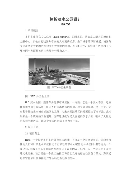
图1.HTO公园全景图HtO滨水公园,座落在多伦多市湖滨区。
一方面,它是一个受人喜爱,适应任意季节的公众场所,能让人们远离城市的喧闹,享受湖边风景;另一方面,它有利于推动未来城市湖滨区的发展,为未来湖滨地区的发展设定了高标准。
此地原来是一个废弃的工业遗址,现在建设成为受人喜爱的滨水公园。
吸引了大量的游客和当地居民,让这个湖滨区充满了活力和生机。
2 設计介绍2.1项目背景HTO,一个位于多伦多的城市海滨海滩,不仅是一个公众赞誉的,适应季节性的人们可以亲近水来放松远自己和远离市中心喧嚣的公共空间,但它更是一个催化剂,为城市的未来海滨的发展制定了较高的设计标准。
从一个废弃的工业用地转化而来,该公园是一个受当地社区和游客欢迎的标志性游览目的地,海滨通过丰富色彩以及多样的户外活动有效地吸引客人。
多伦多的中环海滨带由于城市高速路而与其他的海滨区断开。
HTO是为让人们亲近水而设立的,用独特的流线型设计来吸引人们动态的参与,所以,就要消除那些市中心和安大略湖的障碍。
开放以来,园区在每个季节都吸引了无数游客,并被证明是一个大家都迫切需要的公共空间。
HTO把其他滨水景观也很紧密的联系起来。
2.2项目位置,范围及大小HTO在位于多伦多市中心士巴丹拿街的中环海滨社区支路以东大约只有6英亩的地方,2007年6月建成。
公园被一个条分为两部分:一边是东部毗邻当地消防局,而西侧是一个公寓施工现场。
HTO的设计方案是一个国际设计比赛获奖作品。
公园由沿河滨的木栈道,一个遍布高大黄的伞沙滩,和一个防洪堤组成。
2.3场地和周边调查多伦多整个湖滨区域西到伊桃碧谷溪东到红河,整个跨度约46公里。
世界著名滨水区

世界各国城市滨水区开发掠影横滨21世纪滨水区横滨市开发的这个创造21世纪新城中心区的宏大工程,以其卓越的规划、城市设计和有效的开发实施而举世闻名。
这一带原是临海的造船基地,1983年底开始填海造地和开发建设。
规划开发范围186公顷,其中110公顷利用旧船坞和仓库,76公顷填海造地。
其位置西南紧靠现有市中心,东北滨海,面对海湾大桥,景观壮丽。
土地区划中贸易、商住用地87公顷,公园旷地46公顷,道路、铁路42公顷,港口11公顷。
作为21世纪新区,规划以贸易和国际交流为核心,配置了商贸大厦、会议中心、展览中心、电讯港及多元信息中心、美术馆、海洋博物馆以及滨水步行绿化系统,与原有市中心结合,形成中央商务区。
建筑规模达300~400万平方米,连同毗邻地区改建,可达400~500万平方米。
估计耗资140亿美元。
整个规划以新的基点,新的价值观,新的理论方法创造跨世纪的新城市中心。
提出经济开发、历史文化、城市设计三者紧密结合,摒弃那种牺牲历史文化遗产、无视城市风貌特征、城市空间场所感、城市环境质量,只求城市开发短期最大经济效益的做法。
横滨新区没有把代价昂贵、区位优越的“宝地”用作纯商务中心区开发,而是在中央地区布置美术广场,请丹下健三大师设计横滨美术馆;安排象征横滨历史文化的“日本丸”公园和海洋博物馆;划出总用地25%作公园绿化和居民住宅,以保持和谐的城市综合功能。
横滨将城市设计与立法结合,规定开发用地的容量、规模、高度、步行系统网络和外墙后退界面,达到宏观控制。
例如,规定建筑高度由纵深地带主楼300米,商贸建筑100米,中央地带文化设施45米渐次跌落到近海地带国际交流设施31米乃至滨海地带20米。
让滨水地带向公众开放,组织尽可能长而连续的滨水绿化步行系统,并引向腹地纵深,使之与水保持良好的视觉的和直接的联系。
横滨未来21世纪新区的规划实施,在时间空间上组织得十分有效,如一面填海造地,一面动迁和改建,公共建筑、公园绿地与基础设施同步开发。
【城市滨水】加拿大多伦多HtO滨水公园
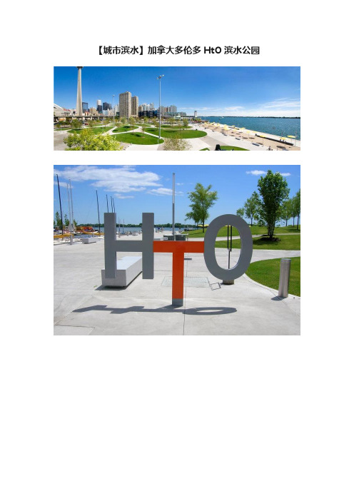
【城市滨水】加拿大多伦多HtO滨水公园
设计:多伦多安大略JRA设计公司
蒙特利尔Claude Cormier Architectes Paysagistes公司;多伦多安大略Hariri Pontarini Acrhitects公司
客户:多伦多市政府
获奖:2009年ASLA综合设计荣誉奖
“这个大胆的设计美化了多伦多市的湖滨地区。
在夏季,HtO海滨公园非常地美丽;而冬天则像夏天一样地美丽,它是一个跟随季节而改变的地区。
”――2009年ASLA专业奖评审团
项目简介
HtO滨水公园,座落在多伦多市湖滨区。
一方面,它是一个受人喜爱,适应任意季节的公众场所,能让人们远离城市的喧闹,享受湖边风景;另一方面,它有利于推动未来城市湖滨区的发展,为未来湖滨地区的发展设定了高标准。
此地原来是一个废弃的工业遗址,现在建设成为受人喜爱的滨水公园。
吸引了大量的游客和当地居民,让这个湖滨区充满了活力和生机。
城市滨水区综合再开发的成功实例──加拿大格兰威尔岛更新改造

城市滨水区综合再开发的成功实例──加拿大格兰威尔岛更新
改造
刘健
【期刊名称】《国外城市规划》
【年(卷),期】1999()1
【摘要】作为一种特殊的城市用地,城市滨水区是城市中具有巨大发展潜力的空间领域。
在工业社会时期,城市滨水区因其便利的交通条件而成为现代城市开发的前沿。
而在后工业社会的今天,城市滨水区再次成为城市再开发的重要内容。
本文系统介绍了加拿大格兰威尔岛的更新改造实践,总结其在指导思想,建设方式、经营管理以及规划设计等方面的经验,对我国类似地区的开发建设乃至城市更新改造具有一定的借鉴意义。
【总页数】3页(P36-38)
【关键词】空间利用;城市更新改造;城市滨水区;综合再开发
【作者】刘健
【作者单位】清华大学建筑与城市研究所
【正文语种】中文
【中图分类】TU984.113;TU984.114
【相关文献】
1.城市滨水区再开发的一则实例:伦敦道克兰地区改造复兴工程述评 [J], 刘志尧
2.城市滨水区景观“再开发”设计研究--以武汉江滩滨水景观概念规划为例 [J], 刘贝妮;阳艳丽
3.城市滨水区开发探析--以增城市增江河西岸综合开发首期工程城市设计为例 [J], 张铭浩
4.英国城市滨水区开发的经验与启示——以卡迪夫湾和伦敦道克兰码头开发为例[J], 邰学东;
5.存量更新背景下城市滨水区的开发与再生--以唐山弯道山151-1号码头更新改造为例 [J], 常胜杰;高德宏;谢庄秀;刘威;穆建祥
因版权原因,仅展示原文概要,查看原文内容请购买。
- 1、下载文档前请自行甄别文档内容的完整性,平台不提供额外的编辑、内容补充、找答案等附加服务。
- 2、"仅部分预览"的文档,不可在线预览部分如存在完整性等问题,可反馈申请退款(可完整预览的文档不适用该条件!)。
- 3、如文档侵犯您的权益,请联系客服反馈,我们会尽快为您处理(人工客服工作时间:9:00-18:30)。
双城布达佩斯
天津
2014-11-16
(6)主从分异型 主从分异型是跨水发展城市的一个特例,指城市已一片广大 陆域为主,在对岸或水城中设置一片或几片岛屿,从属于整个 城市。这类城市往往有广阔的水面,代表城市有厦门,汕头等。
厦门
汕 头
2014-11-16
问题三:绿色开敞空间如何能吸引城市中的活力?
城市公共开敞空间是一个城市中景观最优美的空间,是当今城市规划与建设中最重要的一种空间类型。真正完整的公共开敞空间应该 是系统性的,它应与城市自身的山水资源融为一体,形式多样,贴近生活,让居民能方便到达。避免成为形象工程,片面追求宏大的 效果。 绿色开敞空间应当拥有多样的功能: 1.绿色生态功能,绿色开敞空间应当是城市中最富有活力的部分,能有效调节自然生态环境,增强城市自然环境容量,为城市提供健 康的可持续发展。 2.保护功能,防止火灾的蔓延,洪水的泄洪区,地震时的避难所,甚至可以结合历史建筑进行结合建设,有效保护历史文物。 3.控制功能,合理的布置城市绿色空间,能一定程度上抑制城市的无序蔓延。 4.景观功能,绿色开敞空间应当是城市景观中的重点,结合城市自身的特色进行布置(北京的中轴线,巴黎的香榭丽舍大道),构建 景观走廊(堪培拉国会山俯瞰的三角议会区)。 5.休闲功能,为城市中的居民提供休憩场所。
韩国清溪川改造
进入21世纪.清溪川高架路已经有40余年历史,年久失修给市民和环境都带来安全隐 患,很显然,复原河道是对人和环境最安全的保护办法。清溪川复原工程是一项综合 的系统工程,于2003年7月开工,已于2005年下半年完工。 这座高架曾是高峰时最拥堵的高速路之一,所以当政府决定要拆除恢复清溪川原貌时, 遭到部分市民的强烈反对,认为会令已经很糟糕的交通状况雪上加霜。下图是市民抗 议的情景。
韩国清溪川改造
清溪川规划修建21座跨河桥,其中5座是人行桥.16座是车行桥。下图是人行桥之一的设计效果图。
形态各异的桥,是物质外衣下的文脉符 号,广通桥是其中唯一的古桥,也是西 部商业区和中部商业区的分界点,坐落 在现代高楼之中,不但不显得突兀,反 而作为一个接力点和激励点,激起人们 对清溪川复兴意义的探索。
WEST DON LANDS PRECINCT PLAN(2005)
阅读心得体会
121002106 关涛 121002119 汪洪
九个核心知识点总结
疑问&尝试性解答
总结
九个核心知识点
①学习知名城市的核心设计特色,结合城市自身的传统特色、建筑形式来设计城市中的开敞空间,而这样的空 间会给予这片区域独特而又蓬勃成长力。对于整个城市来说,需要的便是能代表城市底蕴与灵魂的标志性景观。 ②人工景观与自然景观应当有机结合,即便是其中微妙的细节也能给人以深刻的印象。 ③强调街道与绿色开场空间之间的联系,尤其是主要街道,可考虑将其进行深度的绿化妆点,使其成为线型公 园绿地。对于更大范围的城市来讲,可以建设主要景观大道,各个主要道路也应当尽量引导至城市的核心景观 区,为此片区域带来城市中的活力。 ④根据调查得出的交通需求量来合理增设街道,满足市民上下班的通行需求。建设更加亲近的、适宜步行的街 道。减少汽车出行,鼓励公共交通等绿色交通,保证交通的可持续发展。 ⑤鼓励企业建设非盈利性的经济适用房,并且分为不同的价格档次以吸引不同类型的家庭,根据居民需求建设 好社区服务设施。 ⑥滨水地区处于水陆交接地带,蕴含丰富的水域,陆域,岛屿等丰富自然资源,也是生态敏感地区。不难得出 滨水区的规划要以生态学的基本思想为指导,充分发挥滨水地区生态系统的服务功能,促进城市与自然的共生, 即滨水区开发建设必须遵循可持续发展原则。 ⑦滨水区景观设计最为综合复杂涉及内容广泛,不仅包括陆地水里,还有水路交接和濒河湿地。在设计中要最 佳组织调配地域内有限资源,又要保护生态自然,强调景观空间格局对区域生态环境的影响和控制,通过格局 的改变来维持景观功能。要把景观客体和人看做一个生态系统来设计。 ⑧城市滨水区往往是一个城市景色最优美的地区,作为城市公共空间的有机组成部分,城市滨水区在用地形态 上要力求开放化,公共化,实现滨水岸线的共享性原则。鼓励布置旅游,商业,休憩等公共设施,少布置办公 项目,减少或避免布置工业项目。 ⑨滨水区的交通可达性以移动时间,距离,便利程度为标准。所以增加滨水区的可达性,应消除影响滨水区的 物理性障碍,同时注意防止新的物理性障碍的产生,且在滨水区的交通处理上应鼓励无污染公共交通的运用, 限制汽车直接进入滨水区。(多伦多滨水区交通方式有3:步行,自行车,电车)
但清溪川复原后的事实证明,在交通分流等一系列重新规划之后,交通状况非但没 有加剧,反而缓解了这一区块的交通拥堵。
韩国清溪川改造
景观改造过程示意
分段的景观设计理念 在景观设计方面,清溪川项目充分考虑河流区位的特点,在 自然与实用原则相结合的基础上,在不同的河段采取了不同 的设计理念。西部上游河段位于韩国的政治和金融中心,周 边地区包括总统府、市政厅、新闻中心、银行等,景观设计 上处处体现现代化的特点。中部河段穿过东大门地区,那里 是韩国著名的小商品、机械工具、照明商品以及服装鞋帽的 市场,是普通市民和游客喜爱光顾的地方。因此设计上强调 滨水空间的休闲特性,注重为小商业者、购物者和旅游者提 供休闲空间。东部河段周边地区历史上是小市民和贫苦市民 居住的地方,与中部和西部相比,发展相对落后,目前为居 民区和商业混合2。因此,景观设计强调自然和生态的特点 ,使市民和游客们可以找到大自然的感觉。柏 Nhomakorabea 伦 敦
华 盛 顿
堪 培 拉
2014-11-16
(4)组合独立型 这类城市在水域两岸同时发展,各部门之间缺乏紧密的联系,各自具有一定的独立性,然后通过 几个独立发展的部分组合成城市主体。这种模式比较典型的哟偶“一城三镇”的武汉和具有双城布 局的布达佩斯等等。 (5)跨越发展型 城市在水体的每一岸发展,由于城市规模的扩大和城市用地条件的相对紧缺,造成城市跨越水体 至对岸发展。跨越发展的形态是两岸主体建造时间不同,造成在城市组织、肌理形态上的显著差异, 两岸规模也有较大的区别。这类城市比较常见们尤其在我国,比如上海,天津,重庆等。
韩国清溪川改造
丰富的景观设计元素
(1)水体。除了自然化和人工化的溪流以外,清溪川复兴改造工程中还运用了跌水、喷泉、涌泉、瀑布、壁泉等多种水体表现 形式。 (2)植被。平面绿化与垂直绿化结合,以乡土自然植被为主,从芦苇、水边植物、一般草本植物到爬藤植物,采用不同种类和 不同花朵颜色的植物分片种植,旨在对清溪川原有的自然环境系统进行生态恢复,如栽种野蔷薇、光三棱、水葱、垂柳等,这 些乡土植物不仅有较强的生命力,而且多具有发达的根系,可以起到保护河岸的作用。 (3)河岸。清溪川河岸设计采取了多种形式,包括西部上游花岗岩石板铺砌的人工化河岸,中部以块石和植草的护坡为主的半 人工化河岸,以及东部下游以生态植被覆盖的自然化河岸。无论是哪一部分河岸,都强调亲水性的设计理念,充分体现人与自 然的协调。 (4)人文景观。清溪川复兴改造工程中注重通过建设有特色的人文景观来保护和传承历史文化。其中一个重要的举措就是对部 分历史遗迹的恢复和重塑,如恢复重建了极具历史特色的朝鲜时代具有代表性的石桥“广通桥”、“水标桥”以及清溪川向首 尔城外排水的“五间水门”。为了追忆过去传统的首尔市民在溪边洗衣的场景,在清溪川边上新建了“洗衣角”。西部清溪广 场的地板砖取样于韩国传统手工包袱的模样,各不相同。而人物多达1700多名,规模为世界之最的瓷砖壁画“正祖斑次图”则 再现了朝鲜正祖出行水原华城的情景,这些都在向人们传递着传统文化的信息。
巴 黎
纽 约
2014-11-16
(3)协同发展型 协同发展性水滨城市,从城市产生的早期便形成跨越水域相连的整体,在长期的城市发展和形态 演变的过程中,城市始终保持跨越式的双安布局,以这种模式为形态生成特点的城市有柏林与伦敦。 另一类属于协同发展型的城市是经过详细的规划设计,从建设之初即跨越水域,两岸共同发展,比 如华盛顿和堪培拉。
综上所述,通过把人工景观与自然景观完美的结合起来,二者取长补短,互相补充,互不侵犯,使人与自然在合理的设计中彼此共存 。所以对于景观设计来说,“和谐共存”既是设计的基础,又是设计的灵魂。明媚的阳光、清新的空气、宜人的环境、健康的环境是 人类永远的向往。无论是在科技发展中的现在还是在高科技的未来,景观设计都将以“利人”、“实用”为出发点,促使自然景观和 人工景观和谐共生,使各个对立的因素在动态发展中求得平衡,将设计师的自我意识、复杂的环境因素等建构成一个有机的协调性整 体,最大地满足人们对功能和情感的双重要求。以求达到:生态与文化的和谐,自然与人文的和谐,人文诸因素的和谐,人与环境的 和谐,和谐多元化
范例:韩国清溪川改造
清溪川是流经汉城中心区.横贯城市东西的人工河道.起着重要的城市排水作用。由于地理位置的重要.在朝鲜时代的5O0年和 近现代的百年中,清溪川是首尔的历史、文化和市民日常生活中不可或缺的一部分。 在首尔成为朝鲜时代(1392-1910年)初期,清溪川在洪水季节经常泛滥,而在 枯水期由于缺水造成河道污染,因此将河道填平就一直成为人们讨论的一个重要 话题。 1937 年至1942 年日本统治时期,清溪川在历史上第一次被回填,回填的范围自 Gwanghamun 至Gwang桥。在朝鲜独立期间(1945-1950 年)和朝鲜战争期 间,该河的回填工程由于缺少资金而停滞。1958 年到1978年的20 年里完成了该 河段的回填工程,铺设了混凝土路面。Samil 和Cheonggye 两座高架桥分别于 1967 年和1976 年建成,成为穿越汉城市中心的重要交通干线。
李冰父子创造的都江堰水利枢纽,根本没有大规模机械施工,也就丝毫 没有破坏自然生态环境,却能巧妙地为成都平原提供人工水源,直到今 天。这些都是古人在与自然交往的过程中,创造出的一种充满智慧与灵 感的生存艺术,也是他们的生活方式。在他们的日常生产生活中,如何 开垦、利用大地根本就无需刻意为之,高处是果园、低处是稻田、洼地 则是池塘,对自然地理环境利用得很天然。植物的配置亦如此,水稻、 芭蕉、橘树……近乎信手拈来,却美若天成。 人与自然是彼此关联的。人有主观能动性,可以认识自然,并且对自然 进行调整、改造。同时,自然对人类具有反作用。人类按照自己的意志 来征服并且改造自然,在这个过程中不断的调整与自然的关系,达到人 与自然的和谐统一。只有这样才能真正地长期地驯服自然。江堰工程充 分地利用地形特点修建工程,乘势导引灌溉用水,排泄洪水泥沙,体现 了人与自然的协同。
