谷歌街景原理
谷歌地图卫星图街景

谷歌地图卫星图街景谷歌地图是一款广泛使用的在线地图服务,为用户提供全球范围的地图、街景和卫星图像。
其中,谷歌地图卫星图和街景图是两个非常受欢迎的功能,为用户提供了更多全球各地的视角和实景体验。
谷歌地图卫星图,顾名思义,是通过使用人工卫星拍摄的高分辨率图像来展示地球表面的景观和特征。
谷歌地图卫星图是利用谷歌地图卫星图像接口,可以查看真实的地球卫星照片,在全球任意地点浏览地貌和风景。
通过谷歌地图卫星图,用户可以轻松查看地球上的任何地点,从家乡到世界上任何一个角落。
只需在搜索栏中输入地名或地址,地图将自动定位到该位置,并将其显示在屏幕上。
用户可以通过缩放和拖动地图来获取更详细的视图,从全球俯瞰到城市级别的细节。
谷歌地图卫星图为用户提供了更多的地理信息和视觉参考,是许多用户规划旅行、探索新地方或了解陌生地区的重要工具。
例如,如果你正在计划一次旅行,你可以使用谷歌地图卫星图来查看你目的地周围的地理特征,包括山脉、河流和湖泊等。
这样,你就可以更好地了解目的地的地形和自然景观,为你的旅行做好准备。
此外,谷歌地图卫星图还为用户提供了一个机会来探索地球上的一些奇迹和标志性建筑。
你可以使用谷歌地图卫星图来参观埃及的金字塔、美国的大峡谷、法国的巴黎圣母院等。
这些卫星图像给予了用户独特的视角,让他们可以从全球各地欣赏和学习不同文化的遗产。
除了卫星图像,谷歌地图还提供了街景功能,通过街景图像让用户能够“亲临”全球各地的街道和地标。
通过使用车载相机拍摄的街景图像,用户可以在谷歌地图上漫游城市的街道,仿佛置身其中。
街景图像是以360度全方位的方式来呈现,用户可以通过点击和拖动来查看不同方向的场景。
这种沉浸式的体验使用户能够更好地了解夏威夷的海滩、巴黎的街道和纽约的时代广场等地。
对于那些无法实际到访的地方,谷歌地图街景提供了一个逼真的替代选择,让用户能够感受到那些地方的真实氛围。
谷歌地图卫星图街景的应用领域广泛,不仅可以用于旅行规划和虚拟旅游,还可以在教育和研究领域发挥重要作用。
谷歌镜像的原理
谷歌镜像的原理
谷歌镜像的原理
谷歌镜像是指将谷歌搜索引擎网站的数据复制,存储在另外一个服务器上,以达到访问谷歌搜索引擎网站的目的。
谷歌镜像并不是由谷歌公司官方提供的,而是由其他网站或个人自己搭建的。
谷歌镜像的原理可以简单概括为数据同步。
具体地,谷歌镜像服务器通过软件或程序定期访问谷歌搜索引擎,将其中的数据同步到自己的服务器上,跟随谷歌数据更新的节奏不断同步更新。
而用户访问谷歌镜像服务器时,即从谷歌数据的备份中获取相关的搜索结果。
尽管谷歌镜像的访问速度相对谷歌官方网站较慢,而且部分镜像站点的可靠性难以保证,但它有以下几个优点。
首先,谷歌镜像可以作为备选方案,满足用户在无法正常访问谷歌搜索引擎的情况下还能通过镜像站点获取相关信息。
其次,谷歌镜像可以绕过当地的网络封锁和审查,帮助用户获取与搜索相关的信息,特别是一些可能被政府封锁的敏感内容。
同时,谷歌镜像对于一些需要在没有VPN的情况下进入境外网站的用户也是一个不错的选择。
总的来说,谷歌镜像的原理是通过数据同步实现的。
尽管谷歌公司并不提供官方的镜像站点,但由于网络开放和共享思想的流行,个人或网站提供的谷歌镜像站点也可为用户在特定场合下提供有用的信息和服务。
当然,作为一个有责任和感性的网络用户,我们应尽量遵守当地的法律法规和文明的网络行为规范,以维护互联网的健康发展。
谷歌卫星地图的原理和应用
谷歌卫星地图的原理和应用1. 谷歌卫星地图的原理谷歌卫星地图是一种通过卫星和地面传输的数据来制作、展示地球地图的技术和服务。
它通过卫星图像采集、遥感技术和地理信息系统(GIS)等技术手段,将地球表面的影像数据捕捉、处理和制作成高分辨率的地图。
谷歌卫星地图的原理主要包括以下几个步骤:1.1 数据采集谷歌卫星地图的数据采集主要通过卫星传感器进行,卫星上的传感器可以通过高分辨率的遥感影像捕捉地球表面的图像及其他数据。
这些传感器可以记录地球表面的高度、颜色、纹理等信息,并将这些信息转化为数字数据。
1.2 数据传输采集到的遥感数据需要通过卫星与地面接收站进行传输。
卫星将采集到的数据通过无线信号传输到地面接收站,并进行数据解码和处理。
1.3 数据处理接收到的遥感数据在地面接收站进行处理,包括数据解码、校正、配准等操作。
处理后的数据可以通过图像处理软件进行进一步的处理和增强,使得地图更加真实、清晰。
1.4 地图制作经过一系列的数据处理和增强,最终可以将数据制作成谷歌卫星地图。
制作地图时,根据不同的需求可以选择不同的影像处理方法和算法,以获得不同分辨率和样式的地图。
2. 谷歌卫星地图的应用谷歌卫星地图作为一种重要的地图服务,被广泛应用于各个领域。
以下是谷歌卫星地图的主要应用:2.1 地理分析和规划谷歌卫星地图提供了详细的地理信息和影像资料,可以用于地理分析和规划。
通过卫星地图,人们可以对土地利用、地形地貌、交通网络等进行分析和规划,帮助决策者进行科学决策。
2.2 交通导航谷歌卫星地图可以结合全球定位系统(GPS)等导航设备,提供精确的定位和导航功能。
人们可以通过谷歌卫星地图查找目的地、规划路线,实时导航系统可以提供交通状况、道路限速等信息,帮助驾驶者选择最佳的行驶路线。
2.3 旅游和探险谷歌卫星地图提供了全球各地详细的影像数据,人们可以在卫星地图上查看各种旅游景点、自然风光等。
通过卫星地图,人们可以提前了解景点的位置、周围环境、交通情况等,为旅行和探险提供参考和指导。
gsv是什么意思
gsv是什么意思在现代科技发展日新月异的时代,人们对于新兴科技的关注程度也越来越高。
其中,GSV作为一种新型的技术手段,受到了很多人的关注和追捧。
那么,GSV又是什么意思呢?本文将从GSV的定义、应用、优缺点等方面进行详细阐述,帮助读者更好地了解和掌握这一技术。
一、GSV的定义GSV是全景街景视图(Google Street View)的缩写,是由谷歌公司推出的一项网络地图服务。
该服务通过车载摄像头和谷歌地图平台的结合,为用户提供了一个可视化的街景导航系统,用户可以通过这个系统,实现在电脑或手机上进行虚拟街景浏览,以及实现在线导航等功能。
GSV的推出,不仅为地图导航提供了更加真实的视觉效果,同时也让人们更加方便地获取目的地的相关信息。
二、GSV的应用1.导航GSV最初的应用场景是为用户提供更加真实的导航服务。
用户可以通过谷歌地图平台,查找自己需要前往的目的地,并通过GSV提供的街景视图,实现真实的街景浏览。
这种方式可以让用户更加直观地了解目的地的具体位置和周边环境,提高导航的准确性。
2.旅游GSV还可以为用户提供实时的旅游浏览服务。
用户可以通过GSV,实现在电脑或手机上进行虚拟旅游,感受各种著名景点的美丽风光。
这种方式既可以为用户提供更加真实的旅游体验,又可以帮助用户提前了解目的地的具体情况,为旅游计划提供更加详细的信息。
3.教育GSV还可以为教育行业提供更加丰富的教育资源。
通过GSV,学生可以实现在电脑或手机上进行虚拟参观,了解各种历史古迹和文化景点。
这种方式可以为学生提供更加直观的教育体验,帮助他们更好地理解历史和文化。
三、GSV的优缺点1.优点a.可视化效果好GSV提供的街景视图,可以让用户更加直观地了解目的地的具体情况和周边环境,提高导航的准确性。
b.功能丰富GSV不仅可以提供导航服务,还可以为用户提供旅游和教育服务,功能十分丰富。
c.提高效率GSV可以让用户更加快速地获取目的地的相关信息,提高工作和生活的效率。
gsv报告
GSV报告:一步一步的思考引言GSV(Google Street View)是一项由谷歌公司推出的虚拟街景服务,它通过全球范围内的车辆拍摄、图像处理和地理信息系统等技术手段,为用户提供了逼真的街景浏览体验。
GSV的影响已经深入到我们的生活中,不仅为我们提供了便捷的导航服务,还能够帮助我们了解一个地方的实际情况。
在本文中,我们将以“一步一步的思考”为主题,探讨GSV报告的编写过程。
步骤一:确定报告的目的在编写GSV报告之前,我们需要明确报告的目的。
是为了提供关于某一特定地点的详细信息,还是为了分析某一区域的发展趋势?确定了报告的目的后,我们就能够更好地确定报告的内容和结构。
步骤二:选择合适的地点GSV提供了全球范围内的街景浏览服务,我们可以选择任何一个地点作为报告的对象。
但是,在选择地点时,我们应该考虑地点的独特性和受众的需求。
例如,选择一个历史悠久的城市作为报告的对象将会对历史爱好者产生更大的吸引力。
步骤三:收集相关数据在编写GSV报告之前,我们需要收集相关的数据。
这些数据可以包括地点的经纬度、街景图像、交通状况、建筑物信息等。
通过收集这些数据,我们能够更全面地了解一个地点的实际情况,并为报告提供更准确的信息。
步骤四:分析和整理数据在收集了相关数据之后,我们需要对数据进行分析和整理。
我们可以利用数据分析工具,比如Excel或Python等,对数据进行统计和可视化分析。
通过分析数据,我们能够发现地点的特点和规律,并将这些信息整理成报告的形式。
步骤五:编写报告在整理完数据之后,我们需要将数据转化成文字,并编写成报告。
报告的内容应该包括地点的基本信息、交通状况、建筑物特点、周边环境等。
同时,我们还可以根据需要,添加一些图表或地图来更好地展示数据和信息。
步骤六:编辑和校对报告在编写完报告之后,我们需要对报告进行编辑和校对。
我们应该检查报告中的语法错误、排版问题等,并确保报告的逻辑性和连贯性。
同时,我们还可以请他人对报告进行审查,以确保报告的质量和准确性。
gsv报告
GSV报告:Step by Step思考1. 简介GSV(全景街景)是谷歌地图的一项重要功能,通过街景图像和全景摄像机,用户可以在电脑或移动设备上透过屏幕,仿佛置身于真实的街道上。
本文将介绍如何运用Step by Step思维方式去分析和利用GSV报告。
2. Step by Step思维方式的介绍Step by Step思维方式是一种逐步分析和解决问题的方法。
其核心是将一个复杂的任务或问题分解为多个简单的步骤,并逐个解决每个步骤。
通过这种方式,我们可以更加系统和有效地解决问题。
3. GSV报告的意义和用途GSV报告可以为用户提供大量有关特定地点的信息。
通过分析GSV报告,我们可以了解到该地点的环境、交通状况、建筑物结构等等。
这对于商家选择店址、旅行规划、房地产市场分析等方面都有重要意义。
4. Step by Step思维在GSV报告分析中的应用Step 1: 收集GSV报告首先,我们需要收集需要分析的GSV报告。
可以通过谷歌地图或其他相关平台来获取。
确保选取的报告覆盖了我们感兴趣的地点。
Step 2: 了解地点信息通过观察GSV报告,我们可以了解该地点的环境特征,例如是否靠近主要道路、是否有公共交通工具、周边建筑物的类型等等。
这些信息对于商家选择店址或者提供旅行建议非常有帮助。
Step 3: 观察交通状况GSV报告中的街道图像可以提供有关交通状况的信息。
我们可以观察道路是否拥堵、是否有停车位等。
这对于商家选择店址或者规划交通路线都非常重要。
Step 4: 分析建筑物结构GSV报告还可以提供建筑物的全景图像。
通过观察建筑物的结构和外观,我们可以了解该地点的建筑风格、规模等。
这对于房地产市场分析或者旅行规划都非常有帮助。
Step 5: 总结和评估最后,我们需要对收集到的GSV报告进行总结和评估。
根据我们的目标和需求,我们可以得出有关该地点的结论,并作出相应的决策。
5. 总结通过Step by Step思维方式,我们可以更加系统和有效地分析和利用GSV报告。
Google地图搜索功能全面使用攻略

Google地图搜索功能全面使用攻略Google地图是一款广为人知的地理信息软件,不仅提供了精准的导航功能,还包含了丰富的搜索工具,帮助用户快速找到所需的地点或服务。
本文将详细介绍如何充分利用Google地图的搜索功能,以提高使用体验和效率。
一、地点搜索Google地图的地点搜索功能非常强大,可以通过输入关键词或者地址信息,快速找到目标地点并显示在地图上。
为了更好地利用地点搜索功能,以下是一些使用技巧和注意事项:1. 输入关键词在搜索栏中输入相关的关键词,如餐厅、银行、学校等,Google地图会自动匹配相关的地点并显示在搜索结果中。
可以根据自己的需求输入更详细的关键词,如“意大利餐厅”或“24小时银行”。
2. 地点分类Google地图的搜索结果还会按照不同的地点类型进行分类,如餐饮、购物、住宿等。
通过点击分类标签,可以快速浏览到特定类型的地点信息,并在地图上显示相关位置。
3. 附近搜索如果想要在周围搜索特定类型的地点,可以使用“附近”功能。
在搜索栏中输入关键词后,点击“附近”按钮,选择合适的半径范围,Google 地图会显示附近的地点并标记在地图上。
4. 地点详情点击搜索结果中的地点名称,可以查看更详细的信息,如地址、电话、营业时间等。
此外,还可以查看其他用户的评论和评分,以便更好地了解该地点的质量和服务。
二、导航搜索除了地点搜索,Google地图还提供了强大的导航功能,可以帮助用户规划最优路线到达目的地。
以下是一些关于导航搜索的技巧和建议:1. 输入起点和终点在搜索栏中分别输入起点和终点的地址,Google地图会自动计算出最佳的行车或步行路线,并提供详细的导航指引。
选择不同的交通方式,如自驾、公交、步行等,可以得到相应的导航路线。
2. 实时交通信息Google地图可以提供实时的交通信息,帮助用户避开交通拥堵和道路事故。
在导航搜索结果中,会显示当前交通状况,并根据实时情况调整导航路线。
3. 导航选项和偏好在进行导航搜索时,Google地图还提供了许多导航选项和偏好设置,以满足不同用户的需求。
谷歌街景

谷歌街景总是能挖掘出一些令人瞠目的奇特场面,继“马头人”,“倒霉的偷车贼”以及“后备箱中的裸体 男”图片后,23日,谷歌在互联上广泛传播的一幅有关“一妇女在柏林街道上生孩子”的图片被曝造假。
谷歌街景截图:一名女子在街头生孩子这幅图片显示,光天化日之下,一名妇女躺在街道上,一名路人在一 旁协助她把头部抬起,旁边还有一名男子看上去似乎在用手机打叫救护车。而根据这幅图片提供的信息,人们发 现谷歌街景根本就没有这样的图片,所谓的事件发生地也没有人承认发生过类似的事情,因此人们断定这幅图片 是一幅合成的造假图片,造假者很可能是来自德国的艺术家。
突击检查不一定意味着谷歌将会遭到起诉。这种检查在韩国很常见,以此启Vederi科技公司19日向洛杉矶一家联邦法院提交诉状,控告谷歌公司的 “谷歌街景”技术侵犯了其研发的一项专利。
诉状说,“谷歌地图”和“谷歌地球”服务系统中使用的“谷歌街景”技术是Vederi科技公司创始人恩里 科·迪·贝尔纳多和路易斯·贡萨尔维斯共同研发的,所以这项技术的专利应该归属Vederi科技公司。
谷歌街景三轮车针对Google街景车拍到裸女照,Google台湾表示,Google街景车对人的脸孔与车牌号码, 均会予以马赛克处理,避免触犯个人隐私,友对于不妥影像,也可按下“回报问题”,Google有专责部门会处理 这类检举。Google台湾已于2010年3月15日零时三十分移除这张图像。
英国
2010年3月13日英国《每日邮报》报道,谷歌街景照片由于展示出一张裸体儿童的正面照引来非议。3月11日, 一个4岁或5岁的金发男孩照片被上传到谷歌街景照片系统中。拍摄地在伦敦西南温布尔顿,当时这个男孩上完厕 所后,裤子还没有穿上。照片显示这个男孩的妈妈或保姆正在帮他穿衣服,一个男人正在一旁观看。人们担忧那 些恋童癖患者将获得在线搜索照片或目标的新途径。
谷歌地图是怎样炼成的:揭秘谷歌地图的制作过程

谷歌地图是怎样炼成的:揭秘谷歌地图的制作过程9月11日消息,美国《大西洋月刊》(The Atlantic)资深编辑亚历克斯·马德里加尔(Alexis Madrigal)日前发表长篇文章,独家披露了谷歌地图服务的制作过程以及该服务幕后的Ground Truth项目。
以下为文章全文:谷歌地图的幕后制作有一个专门项目为“Ground Truth”在每幅谷歌地图(Google Map)的后面,都有一幅制作过程更为复杂的地图。
这种地图对于网民的查询要求至为关键,但网民却无法看到这类地图。
这种深层次地图包含了各处地点的更多综合信息:街口驾车禁止左转、免费高速公路、公路限速和交通状况等等。
在你向谷歌询问驾车出行路线时,谷歌就会调出这些数据,然后对数据加以分析再向你返回相应答案。
上周期间,谷歌向我展示了该公司的这种内部地图,并演示了其制作过程。
谷歌地图的幕后制作有一个专门项目名称,为“Ground Truth”(简称GT)。
这也是谷歌首次对外演示GT项目的工作原理。
在谷歌业务演进的关键时刻,该公司进一步扩展自身规模。
谷歌最初是一家搜索引擎公司,其主要收入来源为文本搜索广告,即在搜索结果页面发布与用户查询要求相关的广告内容。
后来移动服务大行其道。
如此一来,搜索者所处位置的重要性,已能够与搜索内容本身处于同等重要位置。
面对这种市场新趋势,谷歌有了Android移动操作系统,并为此建立了相应生态系统,并成为唯一能够同苹果iOS相抗衡的产品。
而且谷歌的业务扩张也有着很好理由。
假如说谷歌的使命就是对全球信息进行有序整理,那么其中的最大挑战就是:如何将全球的真实世界信息全部搜集起来,并能够让网民们使用且真正能够给他们提供帮助。
谷歌地图高级产品经理曼尼克·谷普塔(Manik Gupta)对此表示:“如果你关注一下我们生活的现实世界就会发现,真实世界的大量信息尚未完全被发布到互联网上。
为了满足网民们在现实生活中的需求,我们希望能够在现实世界和网络世界之间搭起一座桥梁。
网络隐私保护案例解析
网络隐私保护案例解析引言:随着互联网的普及和发展,网络安全和隐私问题日益受到关注。
随之而来的是各种关于网络隐私泄露的案例也越来越多。
在本文中,我们将分析几个网络隐私保护的案例,并探讨如何避免类似问题的发生。
一、谷歌街景事件谷歌街景事件发生在2010年,当时谷歌公司收集街道图像时,不小心收集到了未加密的Wi-Fi网络数据包。
这些数据包中包含了许多用户的隐私信息,如电子邮件、密码等。
这一事件引起了全球范围内的关注和争议。
一些人认为谷歌公司的行为侵犯了用户的隐私权,而谷歌则表示这是一个技术上的错误,并承诺删除收集到的数据。
最终,谷歌公司被多个国家的监管机构罚款,并被迫改进其数据收集和隐私保护措施。
该事件的启示是,作为用户,我们应该加强对个人Wi-Fi网络的保护,使用安全的网络加密技术,并定期更改密码。
同时,企业也应该加强数据保护意识,确保用户隐私的安全。
二、Facebook数据泄露丑闻2018年,Facebook陷入了一场严重的数据泄露丑闻。
据报道,一家名为“剑桥分析”的数据分析公司通过一款调查应用程序收集了8700万用户的个人数据,并将其用于目标广告和选民操控。
这一事件引起了全球范围内的关注和震惊。
Facebook受到了广泛的批评,指责其保护用户隐私的能力不足。
因此,Facebook被迫采取一系列措施来改进其数据保护和隐私政策,包括限制开发者访问用户数据,并提供更多的隐私设置选项。
这个案例告诉我们,作为用户,我们应该更加谨慎地使用第三方应用,并注意保护自己的个人信息。
同时,企业也应该加强对第三方数据的管控,确保用户数据不被滥用。
三、Uber隐瞒数据泄露事件2016年,Uber公司曾经遭受了一起严重的数据泄露事件。
黑客窃取了超过5700万用户和600万司机的个人信息,包括姓名、电话号码、电子邮件地址等。
令人震惊的是,Uber在发现泄露事件后,并没有立即向受影响的用户和司机通知这一事实,而是选择了支付黑客400万美元来保持沉默。
谷歌镜像技术原理解析
谷歌镜像技术原理解析谷歌镜像技术原理解析在当今信息时代,互联网成为人们获取和共享信息的重要途径。
然而,由于一些地理和政策的限制,访问特定的网络资源可能会受到限制或屏蔽。
为了解决这个问题,谷歌开发了一项称为谷歌镜像技术的创新,旨在帮助用户绕过这些限制并访问被封锁的内容。
本文将深入探讨谷歌镜像技术的原理,以及其所带来的影响和挑战。
首先,让我们了解一下什么是谷歌镜像技术。
镜像技术是指通过在不同的服务器上复制或反射源服务器上的数据来提供相同内容的技术。
在谷歌的情况下,谷歌镜像技术是指通过在不同的服务器上创建副本,使用户能够访问被屏蔽的谷歌服务和内容。
当用户访问谷歌时,他们实际上是连接到谷歌镜像服务器,该服务器上存储着被复制的谷歌数据。
这样一来,用户就可以绕过封锁或限制,获得他们需要的信息。
那么,谷歌如何实现镜像技术呢?首先,谷歌会在被封锁的地区搭建一系列的镜像服务器。
这些服务器被放置在不同的地理位置,以确保用户在不同地区的访问速度和质量都能得到保证。
当用户在被封锁地区访问谷歌时,他们实际上是通过镜像服务器进行访问。
这些镜像服务器会实时同步数据并反射谷歌的内容和服务,以确保用户能够获得最新的信息。
对于谷歌镜像技术的原理,关键的一点是数据同步和反射。
当谷歌的原始服务器上的数据发生变化时,镜像服务器会通过一系列的算法和协议来实现实时的数据同步。
这确保了每个镜像服务器上的数据都是最新的,并且与原始服务器上的数据保持一致。
同时,为了确保镜像服务器能够正常运行并提供高质量的服务,谷歌还采取了一些负载均衡和容错机制,以确保每个镜像服务器都能平均分担流量并保持稳定性。
谷歌镜像技术带来的影响是显而易见的。
首先,它使用户能够绕过被封锁的网络限制,获得对谷歌服务和内容的自由访问。
这对那些生活在高度限制互联网环境下的用户来说,是一个重大的福音。
其次,谷歌镜像技术还促进了信息的自由流动和共享。
它打破了信息壁垒,使得人们能够跨越地域和政治界限,获取和交流知识。
谷歌地图的技术原理及应用

谷歌地图的技术原理及应用谷歌地图,是互联网时代以来最受欢迎的地图服务之一。
如今多数人在出门前都会使用谷歌地图来查询、导航和规划路线。
随着可穿戴设备和车联网的普及,它的应用场景也在不断拓展。
本文将介绍谷歌地图的技术原理和应用。
一、地图数据的来源谷歌地图的原始数据来源包括卫星图像、空中摄影、地图处理服务(如数据分析和特征提取)以及用户上传的地图数据。
除此之外,还涉及道路交通状况、公共交通线路等实时信息的更新,这部分信息通常由与谷歌合作的第三方公司收集。
所有的数据都被存储在庞大的数据中心中,以供下一步的处理和使用。
二、地图的构建在谷歌地图中,地图是由许多层次的元素组成的,包括道路、建筑、公园、水体等元素。
建立这些元素的步骤一般包括:1. 图像处理:首先,利用卫星图像或空中摄影来获取地图区域的图像。
这些图像通常以大量的小图块的形式存储下来,以便更快地处理和查询。
2. 模式提取:谷歌利用算法和人工智能技术从卫星图像和航空摄影中提取有用的地图要素和几何形状。
例如,通过检测像素的颜色和亮度梯度,可以自动提取出建筑物、道路等地物;通过形态分析算法,可以提取出河流、水库等水体。
3. 局部特征提取:到达这步骤时,地图的各种要素都已经被检测出来了,但是由于不同地区之间差异巨大,所以一些有规律的、局部的特征仍然需要进行定制处理。
例如,在一幅卫星图像上,海岸线和河流特征需要进行一定程度的调整和处理。
所有提取出来的特征和几何形状都会被整合和储存起来,成为一张完整的地图,并定期进行更新与维护。
三、地图的应用谷歌地图主要应用于以下方面:1. 驾车/步行导航:谷歌地图提供交通路线规划和实时导航服务,可以自动识别用户的位置和终点,并提供详细的道路和交通状况信息。
2. 公共交通:除了驾车和步行导航之外,谷歌地图还提供公共交通线路规划和实时公交车位置等信息。
3. 实景浏览:谷歌地图提供了大量的卫星图像和基于街景摄影的实景浏览服务。
用户可以“走进”一个地区,像在现场一样进行浏览,既方便又有趣。
谷歌地图拍下了军方的反重力项目
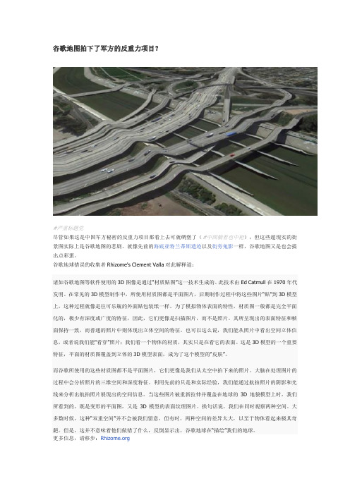
谷歌地图拍下了军方的反重力项目?#严重标题党尽管如果这是中国军方秘密的反重力项目那看上去可就碉堡了(#中国躺着也中枪),但这些超现实的街景图实际上是谷歌地图的悲剧。
就像先前的海底亚特兰蒂斯遗迹以及街旁鬼影一样,谷歌地图又是也会搞出点彩蛋。
谷歌地球错误的收集者Rhizome's Clement Valla对此解释道:诸如谷歌地图等软件使用的3D图像是通过“材质贴图”这一技术生成的。
此技术由Ed Catmull在1970年代发明。
在常见的3D模型制作中,所使用材质图都是平面图片,后期制作过程中将这些图片“贴”到3D模型上,这种过程就像是往可乐瓶的外面贴包装纸一样。
为了模拟物体表面的特性,材质图一般都是完全平面化的,极少有深度或广度的特征,因此,它们更像是扫描图片,而不是照片。
其所呈现出的表面特征和帧面保持一致,而普通的照片中则体现出立体空间的特征。
也可以这么说,我们能从照片中看出空间立体信息,或者说我们能“看穿”照片;我们看一个物体的材质,其实只是在看它的表面。
这是3D模型的一个重要特征,平面的材质图覆盖到立体的3D模型表面,成为了这个模型的“皮肤”。
而谷歌所使用的这些材质图都不是平面图片,它们更像是我们从太空中拍下来的照片。
大脑在处理图片的过程中会分析照片的三维空间和深度特征。
利用先前的只是和实际经验,我们能通过航拍照片的阴影和光线来分析出航拍照片展现出的空间信息。
当这些图片被重新拉伸并覆盖在地球的3D地貌模型上时,我们所看到的,既是变形的平面图,又是3D模型的表面纹理图片。
换句话说,我们在同时观察两种空间。
大多数时候,这种“双重空间”并不会被我们留意,但有时,两种空间的差异太大,以至于物体看起来极其奇葩。
但是,这并不意味着他们做错了什么,反倒显示出,谷歌地球在“描绘”我们的地球。
更多信息,请移步:。
谷歌地图十大恐怖坐标

谷歌地图十大恐怖坐标第一部分、谷歌地图十大恐怖坐标分别为:中东地区公牛的眼睛,南太平洋的幻影岛,金字塔的重现,哈萨克斯坦的大五角星,澳大利亚的UFO,苏丹巨大的嘴唇,新墨西哥州沙漠上的钻石,伊拉克地区的血湖,中东地区的车轮,巨大的商标,这十大恐怖坐标之后有着十分神奇的秘密。
一、中东地区的公牛眼睛从谷歌地图上看,中东地区有一个圆形小区域,如同一只公牛的眼睛,因此这个点的坐标十分奇异。
二、南太平洋的幻影岛在南太平洋上有一个狭长的小岛,从谷歌地图上看,这个狭长的小岛轮廓上有一圈幻影,也引来了观测者的好奇。
三、金字塔的重现从谷歌地图上看,在埃及地区有一个非常偏僻的地方,似乎拥有一个新的金字塔,但是仔细一看,这个地方只是和金字塔十分相似而已。
四、哈萨克斯坦的大五角星在谷歌地图上可以非常清晰地看出,在哈萨克斯坦地区有一个巨大的圆形五角星,这个圆形五角星经过测量,直径达到了370米。
五、澳大利亚的UFO从谷歌地球上观看澳大利亚地区,似乎澳大利亚地区中部有一个大型的UFO停靠站,很多人怀疑这是澳大利亚和外星人联系的地区。
六、苏丹巨大的嘴唇苏丹地区大部分以山地和丘陵为主,但是在山地和丘陵之间,突然出现了一个红色的嘴唇,也引来了人们的好奇心。
七、新墨西哥州沙漠上的钻石在新墨西哥洲地区有一巨大沙漠上,仿佛放置了巨大的钻石,钻石在沙漠地区显得十分的显眼,也有人怀疑这是外星人所建造的。
八、伊拉克地区血湖地球上所有的核的颜色应该都是蓝色,但是从谷歌地图上来看,伊拉克地区有一个湖的颜色为血红色,这确实十分恐怖。
九、中东地区的车轮中东地区有着十分广袤的沙漠,但是沙漠上却出现了许许多多车轮的形状,这些出门的形状有大有小,十分奇异。
十、巨大的商标谷歌地图在美国拍摄了一个最大的商标广告,就是可口可乐公司的广告,可口可乐公司在地上用五颜六色的瓶子摆出了一个肯德基的模样。
第二部分.谷歌地图十大神秘之地,谷歌地图的出现,为大家的生活带来极大方便,同时也引起具有好奇心和探险精神的「好事之徒」,在谷四处搜寻,找到了不少鲜为人知的神秘地带。
罗克韦尔gsv指令的用法

罗克韦尔gsv指令的用法罗克韦尔(Google Street View)是一项由谷歌提供的虚拟街景服务,它利用全球定位系统和车载摄像设备,收集并处理街道的全景图像。
而罗克韦尔GSV(Google Street View)指令是指在罗克韦尔平台上使用的一系列特定指令,用于调整和控制罗克韦尔的功能。
本文将详细介绍罗克韦尔GSV指令的用法,包括指令的格式、常用指令的解释以及如何在应用和开发中使用这些指令。
接下来,让我们一步一步回答这些问题。
1. 罗克韦尔GSV指令的格式是什么?罗克韦尔GSV指令的格式通常由规定的关键词和参数组成,具体格式如下:<指令> <参数1> <参数2> ... <参数n>2. 常用罗克韦尔GSV指令的解释是什么?以下是几个常用罗克韦尔GSV指令的解释:- `move_to`: 用于在街景中移动到指定的地点。
参数可以是坐标、地址或地点名称。
- `look_at`: 用于在街景中查看指定的地点。
参数可以是坐标、地址或地点名称。
- `zoom_in/out`: 用于在街景中调整缩放级别。
参数可以是整数,表示要放大或缩小的级别。
- `rotate`: 用于在街景中旋转视角。
参数可以是角度,表示旋转的方向和角度。
- `tilt`: 用于在街景中调整视角的倾斜度。
参数可以是角度,表示倾斜的程度。
- `capture`: 用于捕捉街景的当前图像。
参数可以是文件名,表示图像保存的位置和名称。
3. 如何在应用中使用罗克韦尔GSV指令?在应用程序开发中,可以使用罗克韦尔GSV指令通过API调用的方式集成罗克韦尔的功能。
以下是一般的步骤:- 获取罗克韦尔的API密钥,以便应用程序可以访问罗克韦尔的服务。
- 在应用程序中设置相应的用户界面元素,如按钮和输入框,以便用户可以输入指令和参数。
- 使用相应的编程语言和库,例如JavaScript和Google Maps API,编写代码来处理和执行用户输入的指令。
国产地图软件也能看到街道实景地图?

国产地图软件也能看到街道实景地图?卫星地图是借助卫星为媒介,向⽤户真实反馈地球地表⾯貌的图。
与传统意义的地图不同,卫星地图上看到的地表⾯貌是真实⽽实时的,因此,卫星地图的使⽤⾯⾮常⼴,⽐如⽤于检测地⾯的信息,探测地理位置、地形等,同时还可以应⽤于城乡规划、导航系统、军事指挥部署、监测灾情、抗灾救灾部署等。
那么,我们如何使⽤百度地图查看卫星地图呢?卫星地图⼜被称作为卫星图,也叫卫星遥感图像,简单来说就是通过卫星探测地球地表物体,从⽽识别提取出来的影像,还原了真实的地理⾯貌,让⼤家可以了解到相关的地理位置、地形等信息,经常被⽤作城乡规划、地图gps定位导航,相对于其他地图,画质画⾯更加清晰逼真、⼀⽬了然。
百度地图看卫星影像打开百度地图,在百度地图的搜索栏中搜索想要查找的该城市的名称,单击放⼤镜图标对该城市地图进⾏搜索此时,百度地图就显⽰出了该城市的地图,在页⾯的右下⾓,有个全景,将光标移到图⽰位置,就会出现地图的三种模式在三种模式中选择(地球),这个模式就是卫星地图模式此时,就能够查看想要查找的该城市的卫星地图百度卫星地图当然百度卫星地图除了通过这种⽅式去查看还可以在上加载百度卫星影像图层,看起来效果会⽐这个更清晰更流畅,同时⽀持多个⾓度进⾏地图查看。
图新地球加载百度影像百度⾃带卫星影像国产地图软件看街景不过百度地图在街景地图上也有技术成果,⽆论是⼿机端还是桌⾯端都能查看所在位置的街景,准确说是实景地图,⼩编测试了⼀下体验还是很不错的,要知道这背后的数据存储成本以及技术运维成本相对之⾼,还要不定期的更新。
这是百度地图产品的⼀⼤亮点,这是⾼德地图软件所没有的那么这个街景地图数据是如何获取的呢?下⾯简单介绍⼀下街景地图的核⼼技术包括3D引擎、云平台存储计算及配套的图形图像技术。
⼤家都知道的⾕歌街景地图技术是做的⽐较早也是⽐较成熟和领先的。
Google⽬前在全球⼤约有250辆街景车,在世界各地趴趴⾛持续建构街景图(根据T客邦在2010年的报导,台湾当时有5辆)。
谷歌街景原理

谷歌街景原理
谷歌街景是谷歌地图的一个功能,可以让用户在地图上查看实时全景照片。
谷歌街景的原理包括以下几个步骤:
1. 采集图像:谷歌使用特殊设备装在汽车、自行车或人们背上,穿越城市和其他地区的街道,拍摄各种角度的照片。
这些设备通常包括多个相机和传感器,用于捕捉全景图像和实时位置信息。
2. 图像拼接与处理:谷歌使用先进的图像处理算法,将采集到的照片进行拼接和处理,创建出连续流畅的全景图像。
这些算法可以识别和匹配照片中的特征,自动对齐和融合图像,消除拼接过程中的不自然过渡和失真。
3. 地理定位:谷歌街景使用GPS技术和惯性导航系统,结合
传感器数据和地图信息,准确地记录每个图像的拍摄位置和朝向。
这样用户在浏览街景时,可以根据自己的位置和朝向,查看与实际街道相匹配的全景图像。
4. 图像发布和访问:谷歌将处理好的全景图像上传到服务器上,并与地图数据相结合,使用户可以通过谷歌地图或其他相应的应用程序访问街景图像。
用户可以在地图上选择不同的地点,并通过拖动、缩放和旋转地图来浏览相应的街景图像。
总的来说,谷歌街景利用专门的设备采集街景图像,通过图像处理和地理定位技术,将这些图像拼接成全景图像,并与地图数据相结合,使用户可以在谷歌地图上浏览实时全景照片。
- 1、下载文档前请自行甄别文档内容的完整性,平台不提供额外的编辑、内容补充、找答案等附加服务。
- 2、"仅部分预览"的文档,不可在线预览部分如存在完整性等问题,可反馈申请退款(可完整预览的文档不适用该条件!)。
- 3、如文档侵犯您的权益,请联系客服反馈,我们会尽快为您处理(人工客服工作时间:9:00-18:30)。
• 谷歌街景也支持不同级别的图片细节。这样就允许你 从默认视野进行缩放控制。通常来说,谷歌街景为每 一处全景照片提供了5个级别的缩放分辨率。要是你 想通过用单独一张全景图片就完成所有级别的缩放, 这样的一张图片要么需要相当大,而这会明显让你的 程序变慢;要么这图片的分辨率就很低,致使当放大 时就变成了一个糟糕的马赛克图像。然而,幸运的是, 我们可以用一种类似用在谷歌地图瓦片上的设计模式 来为各个缩放级别的全景图片提供合适的分辨率图像。
一张完整的环绕一周的全景照片
• Panorama images are generally obtained by taking multiple photos from one position and stitching them together using panorama software. Such images should share a single "camera" locus, from which each of the panorama images are taken. The resulting 360 degree panorama can then define a projection on a sphere with the image wrapped to the two-dimensional surface of the sphere.
• 把全景图当成是在球体上的投影,并用一个 直角坐标系来描述。当需要把图片分割成直 角瓦片,并通过计算瓦片坐标提供相对应的 图片时,这样做是很有好处的。
Creating Custom Panorama Tiles
• Street View also supports different levels of image detail through the use of a zoom control, which allows you to zoom in and out from the default view. Generally, Street View provides five levels of zoom resolution for any given panorama image. If you were to rely on a single panorama image to serve all zoom levels, such an image would either necessarily be quite large and significantly slow down your application, or be of such poor resolution at higher zoom levels that you would serve a poorly pixellated image. Luckily, however, we can use a similar design pattern used to serve Google's map tiles at different zoom levels to provide appropriate resolution imagery for panoramas at each zoom level.
谷歌街景原理
Creating Custom Panoramas
• Each Street View panorama is an image or set of images that provides a full 360 degree view from a single location. The Street View Panorama object uses images that conform to the equirectangular (Plate Carrée) projection. Such a projection contains 360 degrees of horizontal view (a full wrap-around) and 180 degrees of vertical view (from straight up to straight down). These fields of view result in an image with an aspect ratio of 2:1. A full wrap-around panorama is shown below.
• 因为一个全景图片是由一个“等矩形投影”组成, 这样创建全景图像瓦片就会相对简单。尽管正方形 的图像瓦片可能会在正方形的地图上提供更好的表 现(因为视野将是正方形),但因为投影的图像的 长宽比为2:1,所以2:1比例的图像瓦片用起来就会 更简单。
• For 2:1 tiles, a single image encompassing the entire panorama represents the entire panorama "world" (the base image) at zoom level 0, with each increasing zoom level offering 4zoomLevel tiles. (E.g. at zoom level 2, the entire panorama consists of 16 tiles.) Note: zoom levels in Street View tiling do not match directly to zoom levels as provided using the Street View control; instead the Street View control zoom levels select a Field of View (FoV), from which appropriate tiles are sele默认情况下,它 处在缩放等级1,这时显示了整张全景照片25%的 水平宽度(90度的水平视野)。这个视野大致符 合一个正常人的视野。从这个默认视野进行“缩 小”本质上是提供一个更广的视角,而“放大” 则是将视角压窄,视角变小。
• The Street View Panorama automatically calculates the appropriate field of view for the selected zoom level, and then selects imagery most appropriate for that resolution by selecting a tile set that roughly matches the dimensions of the horizontal field of view. The following fields of view map to Street View zoom levels:
180 90 45 22.5 11.25
• Note that the size of the image shown within Street View is entirely dependent on the screen size (width) of the Street View container. If you provide a wider container, the service will still provide the same field of view for any given zoom level, though it may select tiles more appropriate for that resolution instead.
• 用2:1比例的图像瓦片的情况下,一个单张环绕整 个全景的图片就展现全部的全景“世界”(即源 图片),这样的缩放级别(zoomLevel)为0级。 随着缩放的增大,将需要4zoomLevel 块图像瓦片。 (例如,在2级,整张全景图就要由16块图像瓦片 组成。)注意:在铺瓦片时用的缩放等级并不直 接对应控制街景视野的缩放等级;而是街景通过 哪些瓦块适合被选择,来控制缩放级别来选择一 个视野(Field of View (FoV))。
• 要注意,在街景中图片所显示的尺寸完全依赖 于屏幕用来展示街景的容器的尺寸(宽度)。 如果你用一个比原先更宽的容器来显示街景, 服务将仍然提供在某个缩放等级下相同的视野, 尽管它可能会换用更适合当前分辨率的一些图 像瓦片。
• Because each panorama consists of an equirectangular projection, creating panorama tiles is relatively easy. As the projection provides an image with an aspect ratio of 2:1, tiles with 2:1 ratios are easier to use, though square tiles may provide better performance on square maps (since the field of view will be square).
• 谷歌街景全景图自动为所选择的缩放级别计算合 适的视野,然后通过选择一系列大致匹配当前水 平视野尺寸的对应的图像瓦片,来选择最适合该 分辨率的图片。
视野与街景地图缩放级别的对照表
街景缩放级别 Street View zoom level
0 1 (默认级别) 2 3 4
视野(角度) Field of View (degrees)
• 全景照片通常是通过从一个位置拍多张照片并用 全景图片软件将它们拼接在一起制作而成的。要 拍摄这一组全景照片应当让相机安放在一个固定 的点上。这样产生的360度全景照片就可以定义成 是一个包裹在球体二维表面上的投影。