Petrel建模培训2PPT课件
Petrel作断层与层面精品PPT课件
用welltop控 制
3、时深转换
形成深度域层面
4、make zones
检查网格
有两处可对网格进行质量控制:一是网格化后尽量保持其合理,上下面都要 调平,一是作完层后在属性里建立Geometrical modeling 。
点击
新生成文件夹
双击
写在最后
经常不断地学习,你就什么都知道。你知道得越多,你就越有力量 Study Constantly, And You Will Know Everything. The More
1、做等T0层面:
点击
剥蚀或连 续沉积接 触关系, 据实际
默认
时间域 不能加
输入控制层 面:地震时
间域面
据断层多少米以内 不参与计算
某一层面内,可以设置 那些断层不参与
设置 segment
生成时间 域层面
2、建立速度模型
点击
显示速度场
时间域 用welltop控
层面
制
显示速度场
时间域 层面
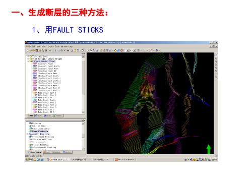
一、生成断层的三种方法: 1、用FAULT STICKS
2、用FAULT POLYGONS 生成断层
打开
POLYGONS 生 成断层
生成结果
调节
3、用层面生成断层
打开顶面 SURFACE
选1点 拾取
打开底面 SURFACE
自动拾取
在点上吸
观察断层已生成
断层间的相互关系
如何建立削截断层
建边界 新建I、J趋势方向
1、选定断层为边界用 全部定 义完
2、把没有边界的部分用 建立 边界段
显示点 点变大变小
3、把工作区以外已选边界部分, 用 定为非边界
Petrel官方地震解释培训M1_2_Data_Import_Cube_handling_and_QC 共22页PPT资料
5. It is possible to scan a specified number of traces to QC the parameter selection
6. In the Input Data Dialog window, select the desired color template and correct domain
2 2. The vintage names are given
sequentially when importing data using Set default vintage
3. All vintage names are editable
3
in the Settings源自dialog box for Generate Attribute cubes Generate Ant-tracking cube Auto generate fault patches Edit fault patches Convert fault patches to fault
interpretation Volume extraction Train Estimation Model
Seismic interpretation
Refine interpretation Horizon operations Make surfaces Surface operations Attribute maps Process Manager Depth conversion Geophysics in Property
3. Set corresponding data type (2D/3D), define vintage and Line detection method
Petrel三维地质建模ppt课件
C B 2 5 B -1 C B 2 5A -7 C B 2 5 A -5
C B 2 5 D -5
C B 2 5 B - C6 B 2 5 B - 3 C B 2 5 A - 8 C B 2 5 D - 1
C B 2 5 B -2 C B 2 5 A -9
C B 2 5 D -2
C B 1 1F -5
依照对断裂系统的认识及目的
层段的深度,过滤组合得到目的层
位的断片系统,并可将其还原为断层
解释数据。
精选PPT课件
15
解释结果验证
断层自动解释技术
埕岛油田馆上(1+2)3小层平面图
油水界面 -1253
油水界面 -1275
通过对蚂蚁追踪流程的改进,有效的验证了低级序断层的
存在,对原有的假设进行了验证,理顺了油水关系,在实际
埕岛油田Nm底构造图
精选PPT课件
27
构造精细建模技术
砂体空间归位技术 断层自动解释技术 三维空间精细调整技术 地震层面精细修正技术 小层层面修正技术
C B 25 1 B -4
C B 2 5 1 A -1
C B 25 1 B -2
C B 2 5 1 B -3
Ng5 457 C B 2 5 1 C -4
C B 2 5 1 C -3
不同 井组
456
403
384
367
7
砂体空间归位技术
CB271A、27A井组轨迹正视图 埕岛油田Ng(1+2)3小层平面图
精选PPT课件
10
断层自动解释技术
问题2:传统的手工断层解释限于地震分辨率在低级序断层的解释上 效果不好?
路 传 统 思
方差体
Petrel2015建模培训2
1.基本概念
测井曲线分布概率与粗化平均方法选择
孔隙度:Arithmetic
岩相:Most of
渗透率:Hormonic Geometry
1.基本概念
Biasing to a Discrete Log
Upscaled facies Raw facies Raw porosity Upscaled porosity
Demo & Exercise
4.Structural Gridding
From Structural Framework to a fully populated property model at any grid cell resolution in just a few clicks!
Fully stair-stepped grid matching the Structural Framework faults and horizons
Cells exist along the well path.
Values assigned to cells based on well log values along the well path.
Upscaled logs used to fill in the 3D grid.
NOTE: An upscaled property will have a [U] following its name in the Property folder in the Models pane.
Input
Output
Structural framework grid
Fault Model
Pillar Gridding
Make Horizons
Petrel地质建模石油大学PPT课件

Columm 6: well name (井名)
注:可以自己设置无效值。
第11页/共67页
设置无效值与 表头行数
第12页/共67页
第一部分:数据文件准备
二、文件格式: 5、fault lines:
Column 1: X Column 2: Y Column 3: Z
注:断层还有很多输入形式,比如:fault polygon、fault sticks等, 除非地质 部门提供,这些方式数据准备起来很困难,所以不推荐使用。
Zmap+ grid Zmap+ grid
Zmap+ grid
Type
Well
Well tops Lines
Lines Lines Surface Surface
Surface
Velocity Data
Zmap+ grid
Surface
Extra data Seismic cube / 2D Images Summary Files
Eclipse grid
Formats SEG-Y
Bitmap (bmp, jpeg....) Petrel summary data
ASCategory
Depth
Depth Fault lines
Fault polygons Fault sticks Evaluation Thickness
第13页/共67页
第二部分:建模过程
建模过程
• Import Data • Structural model • Property model
• Upscaling
第14页/共67页
Import Data-创建工 区
Petrel裂缝分析与裂缝建模技术-工程课件-精心整理

Petrel裂缝分析与裂缝建模技术-工程课件-精心整理Petrel 裂缝分析与裂缝建模技术Petrel 裂缝分析与裂缝建模技术1.裂缝型油气藏分布及裂缝认识方法1)低渗油藏的主要特点2)裂缝认识方法:通常我们容易在岩心描述数据中获得厘米级的裂缝数据,在地震断层数据中获得公里级的裂缝数据,在露头数据中获得米级、十米级的裂缝数据。
2.裂缝建模理论基础3.裂缝建模理论难点4.Petrel软件裂缝建模1)裂缝强度曲线生成2)裂缝古构造挠曲度分析3)裂缝与断层距离分析4)开发动态对裂缝发育的认识5)裂缝发育方向分析6)裂缝强度属性模拟7)裂缝强度约束下的DFN模拟8)模型粗化5. 影响裂缝发育的地质因素很多,各种因素互相作用,使裂缝分布难以预测。
一般从三个角度来进行,一是针对构造应力场和曲率,二是用统计地质学预测井间裂缝分布,三是充分利用地震资料预测裂缝的空间分布。
裂缝性储层地质建模技术1、裂缝表征参数描述1)裂缝的倾角频率分布图2)裂缝的间距分布图3)裂缝的方位分布图2、裂缝的测井识别3、裂缝的空间分布预测1)构造恢复法2)有限元法3)光弹模拟实验裂缝建模软件ReFract简介1、目前有哪些裂缝建模技术1)地质力学模拟(Geomechanical Modeling)模拟过程极为复杂。
主要依据是构造恢复。
过分简化了裂缝成因,只考虑构造变形,而忽视了岩性分布、岩石物性、和其他复杂地质现象对裂缝发育的影响。
2)离散裂缝网络(Discrete Fracture Network,DFN)对裂缝的模拟采用离散的方法。
非常依赖井中成像数据。
可以较精确的模拟近井位置的裂缝分布,对远离井位的裂缝描述精度较差。
只能使用地质与地震属性的二维分布图来制约裂缝模型的生成。
因此,只适合有大量成像井的区域,而不适合少井的勘探区域。
3)连续裂缝分布模型(Continuous Fracture Models,CFM)与传统地质建模相同的三维空间网格。
Petrel裂缝分析与裂缝建模技术-工程课件-精心整理

Petrel 裂缝分析与裂缝建模技术Petrel 裂缝分析与裂缝建模技术1.裂缝型油气藏分布及裂缝认识方法1)低渗油藏的主要特点2)裂缝认识方法:通常我们容易在岩心描述数据中获得厘米级的裂缝数据,在地震断层数据中获得公里级的裂缝数据,在露头数据中获得米级、十米级的裂缝数据。
2.裂缝建模理论基础3.裂缝建模理论难点4.Petrel软件裂缝建模1)裂缝强度曲线生成2)裂缝古构造挠曲度分析3)裂缝与断层距离分析4)开发动态对裂缝发育的认识5)裂缝发育方向分析6)裂缝强度属性模拟7)裂缝强度约束下的DFN模拟8)模型粗化5. 影响裂缝发育的地质因素很多,各种因素互相作用,使裂缝分布难以预测。
一般从三个角度来进行,一是针对构造应力场和曲率,二是用统计地质学预测井间裂缝分布,三是充分利用地震资料预测裂缝的空间分布。
裂缝性储层地质建模技术1、裂缝表征参数描述1)裂缝的倾角频率分布图2)裂缝的间距分布图3)裂缝的方位分布图2、裂缝的测井识别3、裂缝的空间分布预测1)构造恢复法2)有限元法3)光弹模拟实验裂缝建模软件ReFract简介1、目前有哪些裂缝建模技术1)地质力学模拟(Geomechanical Modeling)模拟过程极为复杂。
主要依据是构造恢复。
过分简化了裂缝成因,只考虑构造变形,而忽视了岩性分布、岩石物性、和其他复杂地质现象对裂缝发育的影响。
2)离散裂缝网络(Discrete Fracture Network,DFN)对裂缝的模拟采用离散的方法。
非常依赖井中成像数据。
可以较精确的模拟近井位置的裂缝分布,对远离井位的裂缝描述精度较差。
只能使用地质与地震属性的二维分布图来制约裂缝模型的生成。
因此,只适合有大量成像井的区域,而不适合少井的勘探区域。
3)连续裂缝分布模型(Continuous Fracture Models,CFM)与传统地质建模相同的三维空间网格。
裂缝属性分布在整个三维空间,是真正意义上的三维裂缝分布模型。
petrel属性高级建模2

( x11) ( x12 ) ( x ) ( x ) 22 21 ... ... ( xn1 ) ( xn 2 ) 1 1
... ( x1n ) 1 1 ( x10 ) ( x ) ... ( x2 n ) 1 2 20 ... ... ... * ... ... ... ( xnn ) 1 n ( xn 0 ) 1 1 0 1
Petrophysical Modeling
Stochastic & Deterministic Petrophysical modeling Use of secondary information for property modeling
Kriging: Concept
Kriging is an Estimation Technique/mapping method based on fundamental statistical properties of the data (Mean and Variance). Assumption of data set: Stationarity (Mean does not change laterally, no trends). Inputs: Data set (normally Well data). Variogram and CDF curve. Use and Limitations: Trend search and visualization of trends. Smooth and locally accurate results. Does not handle extreme values very well.
精选Petrel入门培训02断层建模Pillar网格化资料

设置
Pillar Gridding
结果
顶部框架ridding
总结
• 3D网格是2D网格在3D空间内的延伸。2D网格由沿X,Y方向(2D)分布的行 和列来定义。3D网格则由沿X,Y和Z方向(3D)分布的行、列和Pillar来定 义。我们也可以把3D网格看作是由一系列二维网格堆叠而成,连接每个 2D网格对应节点之间的线就是Pillar。
要足以表示断层的形状
记住:
• 如果断层形状不正确,必须做修改时,使用的 pillars和shape points (形状点)越多,修改工作就变 的越困难。
Fault Modeling
总结
• 断层建模 在Petrel里是一个制图的过程。在这个过程中,用表示断层 的数据文件来定义断层的初始形状。用户使用key pillars创建这些断 层。Key Pillar基本上是一个由2,3或5个点定义的(Shape Point形 状点),位于断层面内的垂线。一系列的Key Pillars横向连接在一起, 定义了断层的形状和范围。
Fault Modeling
Pillar网格化
Pillar Gridding
网格化的学习目标 学习怎样创建合适的边界 学习怎样设置I,J方向和趋势线 学习怎样处理异常网格
Pillar Gridding
1、 根据Key Pillar的中间形状 点创建一个网格。
概述
2、 将pillars外推到顶,底形状 点。这将创建一个3D的Pillar网 格,分别由顶,底和中间点表示 。。
课程内容和安排
• 介绍
• 熟悉Petrel界面 • 数据加载 • 编辑输入的数据
• 地层对比
第二天
• 回顾第一天的内容 • 断层建模 • Pillar 网格化
Petrel培训总PPT课件
地质调查—地球物理/化学勘探—发现圈闭—
油 气
油气藏勘探
布置预探井—录井/测井/固井/完井—试井— 地层测试—评价勘探—提交探明储量
藏
勘
探
与
开
发
开发准备—开发设计(油藏描
油气藏开发
述和油藏工程)—开发实施—
投产—开发管理
第3页/共121页
总体来说,勘探就是发现油气藏,开发就是认识油气藏、评价油气藏、开采油气藏、 管理油气藏、油藏数字化。
介绍Petrel
Geology/地质 Seismic/地震
Modeling/建模
Simulation/数模 Geology/地质
第12页/共121页
介绍Petrel
1、加载井头
井头文件是一个ASCII文件,定义*井名,*井口坐标(X-Y) ,*补心海拔(KB),底深 (TD/MD)和井类别(symbol)(可以不选)。
第27页/共121页
1、井分类及快速搜索
第28页/共121页
第29页/共121页
2、分深度显示井轨迹
构造面 上下浮动数值
第30页/共121页
3、井位过滤筛选
根据井属性 根据测井曲线 根据地质分层 边界内井筛选
第31页/共121页
4、测井曲线计算
研究区裂缝ILD一般小于等于20Ω•m,AC一 般大于等于230 μs/m,CNL大于等于23, 通过计算器可以构建一条简易裂缝识别曲 线。
第20页/共121页
数据加载
第21页/共121页
数据加载
6、加载地震层位
第22页/共121页
数据加载
7、加载工区边界
第23页/共121页
数据加载
Petrel入门培训02断层建模Pillar网格化

在每一个网格角处都会创建一个Pillar 。
Pillar Gridding
边界: 多边形Polygon, 边界段或者 边界的一部分。
趋势Trends: 指导网格化,并用作segment divider段块的分界线。
断层和方向: 指导网格化,可以设为没有断层 ,没有边界。
段块Segments: 被断层或趋势线所封闭的区域
要足以表示断层的形状
记住:
• 如果断层形状不正确,必须做修改时,使用的 pillars和shape points (形状点)越多,修改工作就变 的越困难。
Fault Modeling
总结
• 断层建模 在Petrel里是一个制图的过程。在这个过程中,用表示断层 的数据文件来定义断层的初始形状。用户使用key pillars创建这些断 层。Key Pillar基本上是一个由2,3或5个点定义的(Shape Point形 状点),位于断层面内的垂线。一系列的Key Pillars横向连接在一起, 定义了断层的形状和范围。
构造模型
概述
构造建模流程
创建构造模型
Fault Modeling
创建断层模型
Pillar Gridding Make Horizons Make Zones
Layering
定义网格垂向和横向分 辨率
插入地震层位以及网格 化
用井标志点优化模型
根据地质条件定义模型 的垂向分辨率
断层建模
Fault Modeling
课程内容和安排
• 介绍
• 熟悉Petrel界面 • 数据加载 • 编辑输入的数据
• 地层对比
第二天
• 回顾第一天的内容 • 断层建模 • Pillar 网格化
Petrel 课程PPT超全
井的顶深度和底深度 是测量深度。
类别可以 不给出。
加载井数据 井头数据
1- 插入一个Well Folder 2- 鼠标右键点击井文件夹,选择“根
据选择加载” 3- 选择要加载的数据文件和正确的格 式 4- 指明数据文件的每一列对应哪种属
性。
加载井数据
1- Wells上点击右键,选择 Import(On Selection)
建新的井剖面
层位(标记)对比 Marker Correlation 使用计算器或手工创建离散测井曲线(岩相/岩性) 用不同方式填充测井曲线
Well Section
1- 创建Well Section Window
显示数据
2- 选中井剖面1前的选择 栏,选择要显示的井 和测井曲线。
可以使用的数据加载格式:
• Charisma lines (ASCII) • IESX Lines, 2D and 3D (ASCII) • Kingdom seismic lines, 2D and 3D
(ASCII) • Seisworks Horizon picks • Irap Classic lines (ASCII/binary),
2。 进入操作窗口
运算器中所有的操作也存在 于操作窗口下。
3。 选择合适的操作
• Polygon Operations 是用来对已经存在的 polygons以及属于polygon的点进行操作。
• Make/Edit polygons process:对 plolygon的各种操作,包括: 创建新polygons , 在合适的位置将其分开,通过点击和移动对每 一个点或者线进行编辑。交互编辑。
-或
2- 将Excel文件直接粘贴进Well Tops ( 层位标记)编辑器。
Petrel高级培训课件

2、断层处理
批量导入断层,并且可以在settings中进行批 量修改圆滑度等参数,得到右边的结果
断层接触的几种接触关系处理—情况1
黄色断层与红色断层没有接触,先选择黄色断层,再右键点击红色断层,增加 断层外推距离,讲两条断层相交。
断层接触的几种接触关系处理—情况2 针对这类断层,必须处理原数据,讲 蓝色断层的左边归为黄色断层
数据分析,变差函数调节-data analyse模块中主要是为了得到各种沉积微相占 得比例和变差函数中的几个参数(最主要的是为了得到垂向厚度这个值)
所有的zone是 一起做的,点击 一下前面的 zone就可以实 现所有的zone 一起做
该值可以调节
分别为主变程、次变 程和垂向厚度
找一口数据资 料齐全的井
选择要调整的点
激活该模块
选择要调整点的影响范围下拉选择调整的形状
laying 如果有等厚图约束的话,就要做make zones这一步,没有的话就不需要
做完上面那步,就可以查看生成的网格是否正确,生成的网格不能是负的
生成它,双击就可以查看网 格的体积是否是负的
数据分析、相建模和属性建模
数据粗化
构造成面——Make velocity model下生成的model在models窗口下看——General depth conversion(将地震、地震解释结论等转化为深度域的)
加载曲线格式,只认MD 文件格式
此处重命名就是新 生成文件的名称
选择前面新建 的岩性模板
若生成的与建立模板的颜色 不一致,双击lith
可以修改画的边界
利用此键画模型 边界
画完边界之后 选中断层两白 点之间变为黄 色点 ,生 成
设定网格方向
设定网格趋势, 注:方向是必须的, 趋势不是必须的
- 1、下载文档前请自行甄别文档内容的完整性,平台不提供额外的编辑、内容补充、找答案等附加服务。
- 2、"仅部分预览"的文档,不可在线预览部分如存在完整性等问题,可反馈申请退款(可完整预览的文档不适用该条件!)。
- 3、如文档侵犯您的权益,请联系客服反馈,我们会尽快为您处理(人工客服工作时间:9:00-18:30)。
Excellent geometry even along the faults
Allows more complex modeling
Modeling or reservoir engineering view- flexibility &deeper integration
Cells exist along the well path.
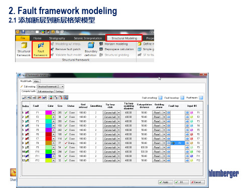
2.3 断层参数设置
Demo & Exercise
3. Horizon modeling
3.1 输入层面、地质分层、定义地层接触关系
3. The framework fault model is stored under the active model in the Models pane.
4. Run the Horizon modeling process located under the Processes pane > Structural framework.
2. Fault framework modeling
2.1 添加断层到断层格架模型
整体 概述
一 请在这里输入您的主要叙述内容
二
请在这里输入您的主要 叙述内容
三 请在这里输入您的主要叙述内容
2. Fault framework modeling
2.2 确定断层间关系
2. Fault framework modeling
3. Horizon modeling
3.2 断层过滤参数设置
3. Horizon modeling
3.3 应用地质规则并生成Zone
QC the Horizons in the display window, if satisfied, continue building the zones through the Horizon modeling process. 6. Reopen the Horizon modeling process, toggle on
5. Drop in number of rows equal to the amount of horizon input. Use, e.g., surfaces stored in the Input pane as input. Set horizon types and click OK. Results are stored under the Horizons folder under the active model.
井点地层 厚度计算
地层厚度 网格化
时深转换
网格几何属性建模
纵向网格化
N
测井曲线 粗化 QC
Y
N
Y
岩相QC
N 三维网 格QC
岩相建模
Y 数据分析
模型粗化 油藏数模模型
历史拟合
储量吻合 N
Y
Y 井历史生 产数据吻合
Y
属性QC
N
油田动态管理
属性建模
方案调整、加密井网
预测模拟
经济评价
N
输出断层模型到角点网格模型
to Apply geological rules and create zone model. Click OK.
7. Visualize the zone model in the display window.
Demo & Exercise
4.Structural Gridding
From Structural Framework to a fully populated property model at any grid cell resolution in just a few clicks!
Output
六、测井曲线粗化
数据查询与研究工区生成 基于Studio知识库的Petrel一体化研究流程
地层划分与对比 合成地震记录 岩相解释
测井曲线粗化 储量计算
构造 解释
地震属性分析
层位编辑 断层建模
网格
正交性
Y
QC
Y
网格体
N
积 QC
构造格架 网格化
建立地层格架
地层格
N
架QC
Y
速度建模uctural Framework
Structural Gridding
4. Structural Gridding ---- Process
Grid name Input Structural Framework
Layer pinchout settings
Optional AOI: enables grid creation on a sub-set of the Structural Framework
This process alows the user to create a geocellular grid which can be later populated with properties
Input
Output
Structural framework grid
Fault Model
Pillar Gridding Make Horizons
Grid geometry settings
Faults tab: include or exclude Structural Framework faults inside the grid
Zonation settings and optional forced well-tie Layering settings by zone
五、测井曲线粗化
❖ 1.基本概念 ❖ 2.测井曲线粗化过程 ❖ 3.测井曲线粗化质量控制
1.基本概念
Overview
The Scale up well logs process averages the values to the cells in the 3D grid that are penetrated by the wells. Each cell gets one value per upscaled log. These cells are later used as a starting point for Property modeling.
